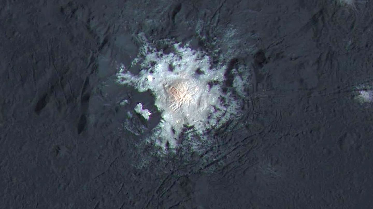
The bright central spots near the center of Occator Crater are shown in enhanced color in this view from NASA’s Dawn spacecraft. The view was produced by combining the highest resolution images taken in February 2016 at an image scale of 115 feet (35 meters) per pixel with color images obtained in September 2015 at a lower resolution added. Click for a highest-res view. Credit: NASA/JPL-Caltech/UCLA/MPS/DLR/IDA/PSI
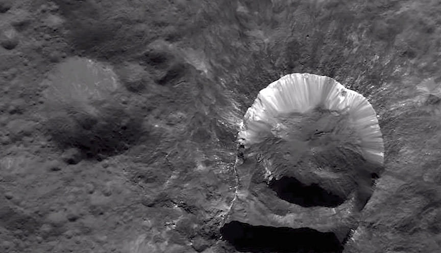
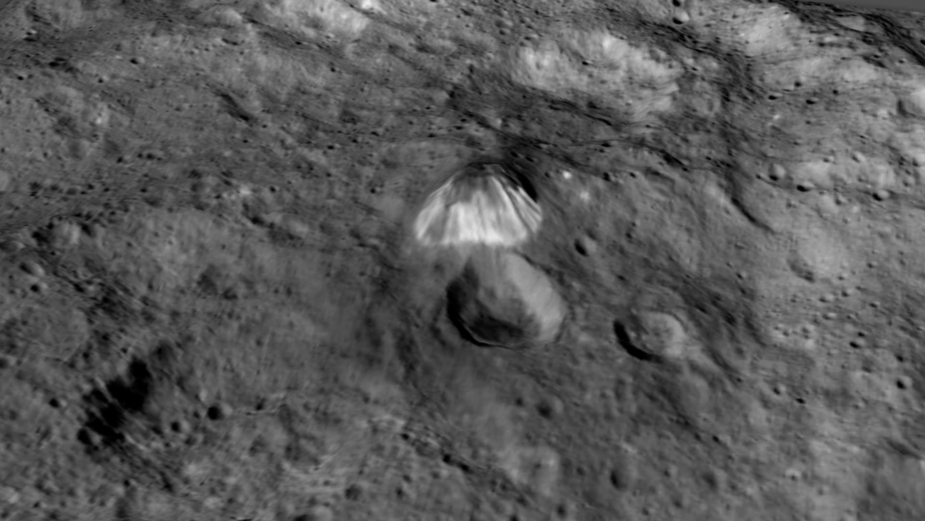
Ah, dome sweet dome. Scientists from NASA’s Dawn mission unveiled new images from the spacecraft’s lowest orbit at Ceres, including highly anticipated views of Occator Crater, at the 47th annual Lunar and Planetary Science Conference in The Woodlands, Texas, on Tuesday. The new images, taken from Dawn’s low-altitude mapping orbit (LAMO) of 240 miles (385 kilometers) above Ceres, reveal a dome in a smooth-walled pit in the bright center of the crater. Linear fractures crisscross the top and flanks of the dome with still more fractures slicing across the nearby plains.
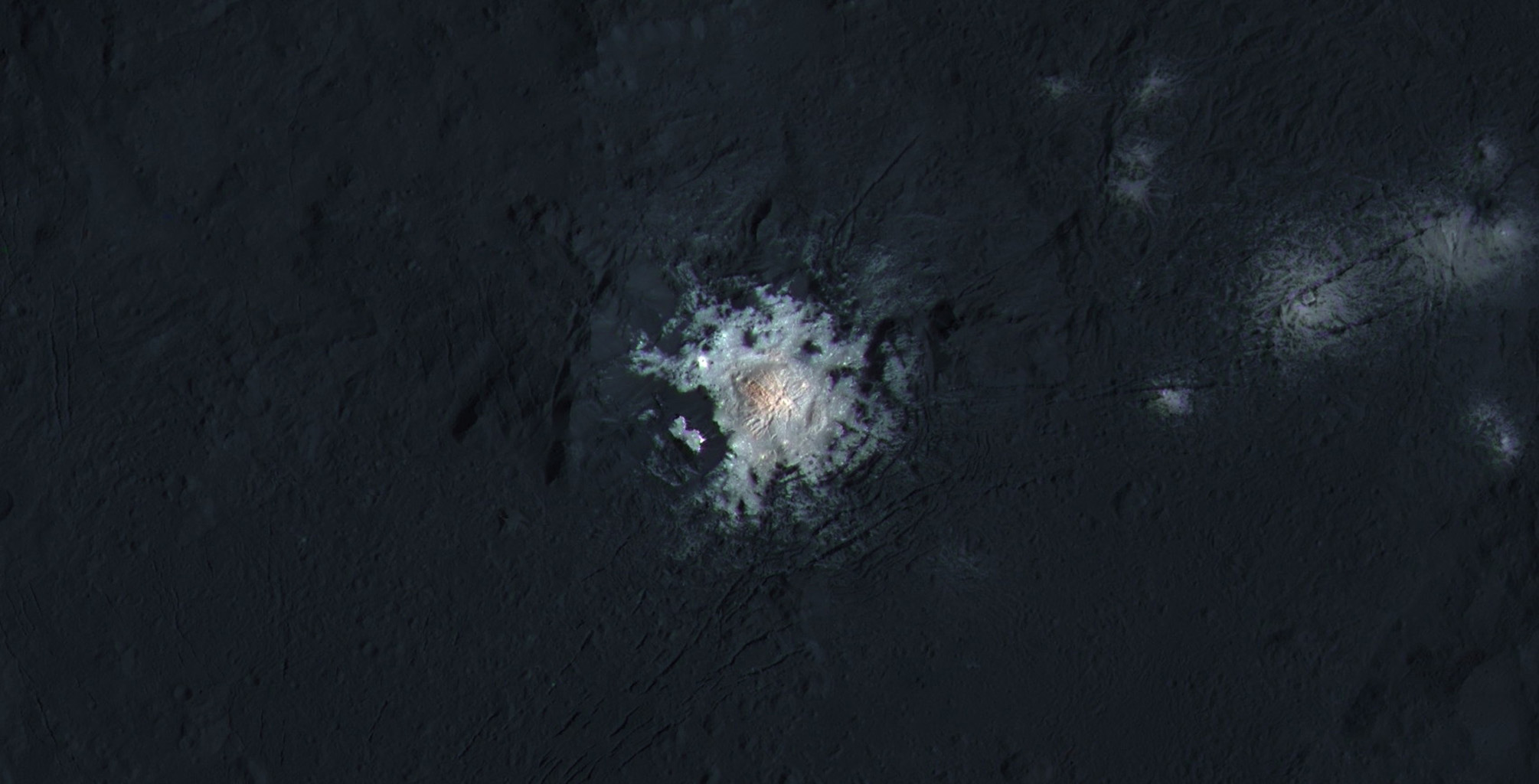
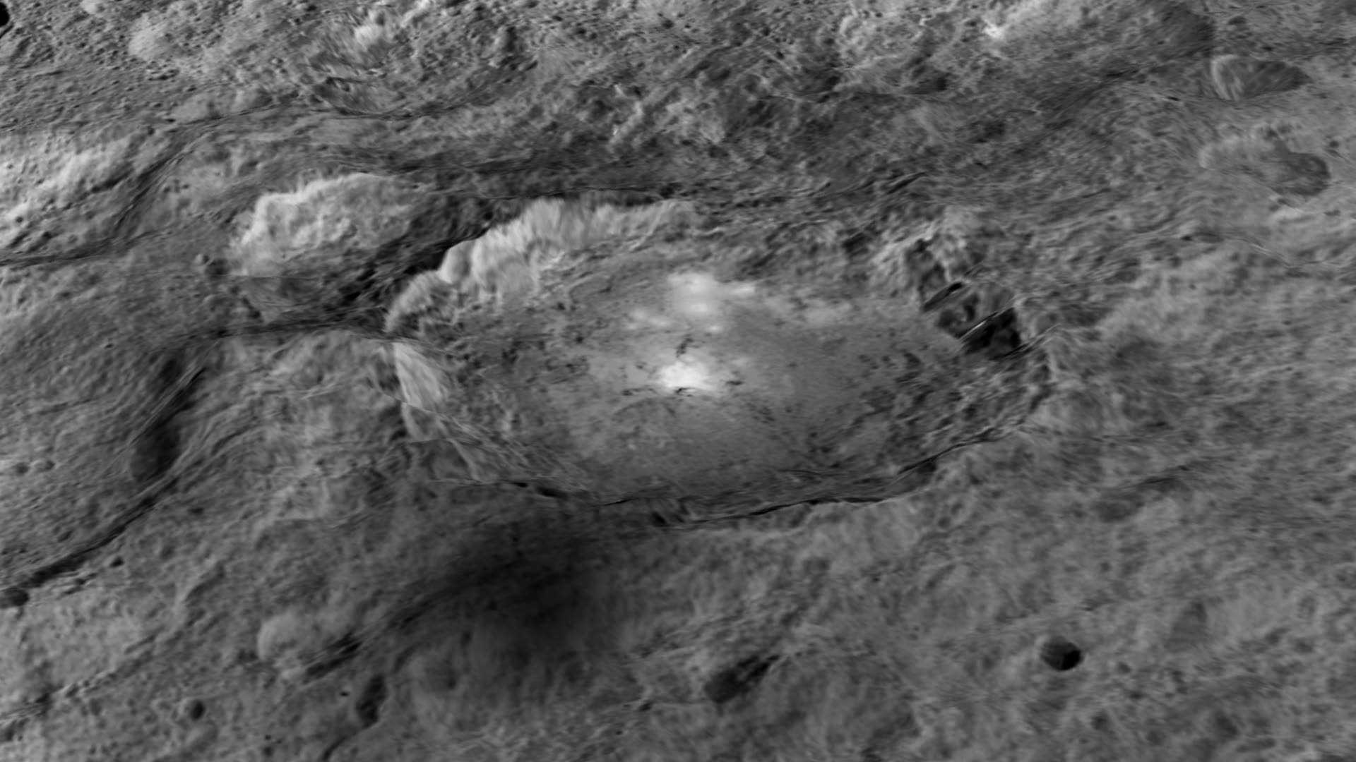
Occator Crater, measuring 57 miles (92 kilometers) across and 2.5 miles (4 kilometers) deep, contains the brightest area on Ceres. This photo has been exposed to show detail in the crater and landscape, so the bright spots are overexposed. The closeup photos on the other hand are correctly exposed to show detail in the spots but necessarily underexpose the landscape and make it look very dark. Credit: NASA/JPL-Caltech/UCLA/MPS/DLR/IDA/PSI
“Before Dawn began its intensive observations of Ceres last year, Occator Crater looked to be one large bright area. Now, with the latest close views, we can see complex features that provide new mysteries to investigate,” said Ralf Jaumann, planetary scientist and Dawn co-investigator at the German Aerospace Center (DLR) in Berlin. “The intricate geometry of the crater interior suggests geologic activity in the recent past, but we will need to complete detailed geologic mapping of the crater in order to test hypotheses for its formation.”
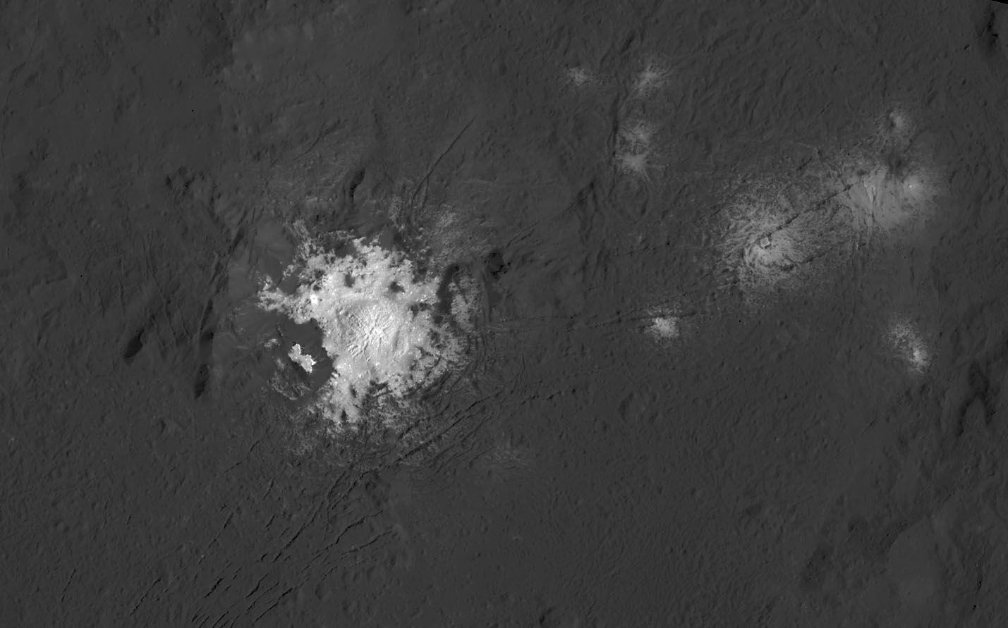
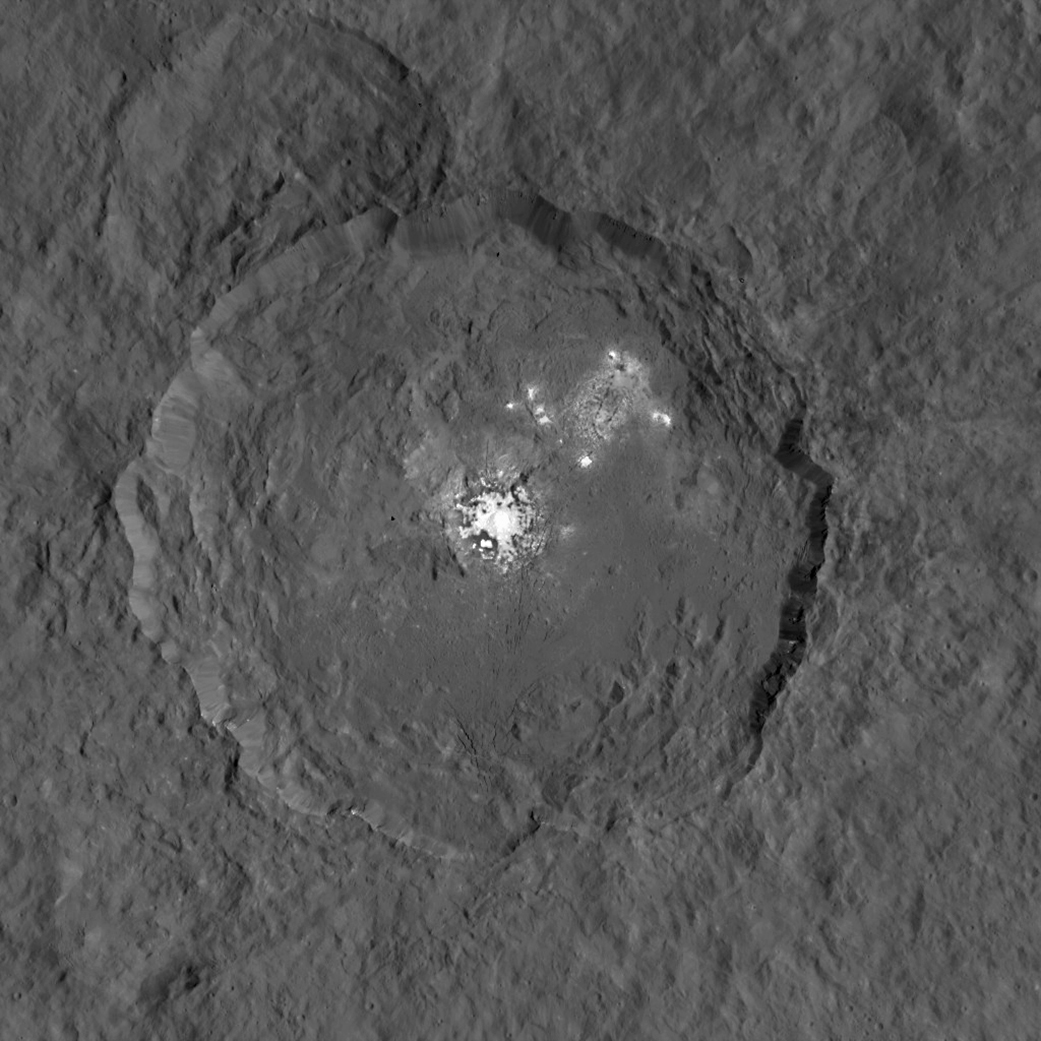
Black and white view of the bright spots in Occator Crater. Credit: NASA/JPL-Caltech/UCLA/MPS/DLR/IDA/PSI
Like me, you’ve probably been anticipating LAMO for months, when we’d finally get our clearest view of the famous “bright spots”. Spectral observations have shown that the patches are consistent with a magnesium sulfate called hexahydrite that resembles the more familiar Epsom salts here on Earth. Scientists think these salt-rich areas were residue left behind when water-ice sublimated in the past. Impacts from asteroids could have broken into Ceres’ crust and possibly unearthed salt-rich ices. Exposed to the vacuum of space, the ice would have sublimated (vaporized), leaving the salt behind.
This global map shows the surface of Ceres in enhanced color, including infrared wavelengths beyond human visual range. Photos were taken using infrared, green and blue filters and combined to create this view. Credit: NASA/JPL-Caltech/UCLA/MPS/DLR/IDA/PSI
The team also released an enhanced color map of the surface of Ceres that reveals a diversity of surface materials and how they relate to Ceres’ landforms. The dwarf planet doesn’t have as many large impact basins as scientists expected, but the number of smaller craters generally matches their predictions. The blue material highlighted in the color map is related to flows, smooth plains and mountains, which appear to be very young surface features.
“Although impact processes dominate the surface geology on Ceres, we have identified specific color variations on the surface indicating material alterations that are due to a complex interaction of the impact process and the subsurface composition,” Jaumann said. “Additionally, this gives evidence for a subsurface layer enriched in ice and volatiles.”
This map shows part of Ceres’ northern hemisphere with neutron counting data from Dawn’s gamma ray and neutron detector (GRaND) instrument and reflect the concentration of hydrogen in the upper yard (or meter) of regolith, the loose surface material on Ceres. Colors are based on the number of neutrons detected per second by GRaND. Counts decrease with increasing hydrogen concentration. The color scale of the map is from blue (lowest neutron count) to red (highest neutron count). Lower neutron counts near the pole suggest the presence of water ice within about a yard (meter) of the surface at high latitudes. Credit: NASA/JPL-Caltech/UCLA/MPS/DLR/IDA/PSI
We’re learning more about that subsurface ice thanks to Dawn’s Gamma Ray and Neutron Detector (GRaND). Neutrons and gamma rays produced by cosmic rays interacting with the topmost yard (meter) of the loose rock and dust called regolith provide a fingerprint of Ceres’ chemical makeup. Lower counts indicate the presence of hydrogen, and since water’s rich in hydrogen (H2o), the results from GRanD suggest concentrations of water ice in the near-surface at high latitudes.
“Our analyses will test a longstanding prediction that water ice can survive just beneath Ceres’ cold, high-latitude surface for billions of years,” said Tom Prettyman, the lead for GRaND and Dawn co-investigator at the Planetary Science Institute, Tucson, Arizona.
Ceres’ Oxo Crater (right) is the only place on the dwarf planet where water has been detected on the surface so far. Credit: NASA/JPL-Caltech/UCLA/MPS/DLR/IDA/PSI
Dawn scientists also reported that the Visual and Infrared Mapping Spectrometer (VIR) has detected water at Oxo Crater, a young, 6-mile-wide (9-kilometer-wide) feature in Ceres’ northern hemisphere. This water could either be bound up in minerals or exist as ice and may have been exposed during a landslide or impact or a combination of the two events. Oxo is the only place on Ceres where water has been detected at the surface so far.
Ceres’ Haulani Crater (21 miles, 34 kilometers wide) is shown in these views made with VIR. They reveal variations in the region’s brightness, mineralogy and temperature at infrared wavelengths in the types of rock and ejected material around the crater. Scientists see this as evidence that the material in this area is not uniform, and that the crater’s interior has a different composition than its surroundings. Credit: NASA/JPL-Caltech/UCLA/MPS/DLR/IDA/PSI
Not only have scientists found evidence of possible extensive subsurface ice, but the composition of the surface is variable. Using VIR, which measures mineral composition by how those minerals reflect sunlight, they found that Haulani Crater shows a different proportion of surface materials than its surroundings. While the surface of Ceres is mostly made of a mixture of materials containing carbonates and phyllosilicates (clays), their relative proportion varies across the surface.
“False-color images of Haulani show that material excavated by an impact is different than the general surface composition of Ceres. The diversity of materials implies either that there is a mixed layer underneath, or that the impact itself changed the properties of the materials,” said Maria Cristina de Sanctis, the VIR instrument lead scientist.
All these cool stuff we’re finding out about this small body makes it nearly as exciting as Pluto. Taking a closer look is the best form of education.
This image, made using images taken by NASA's Dawn spacecraft during the mission's High Altitude Mapping Orbit (HAMO) phase, shows Occator crater on Ceres, home to a collection of intriguing bright spots. Credits: NASA/JPL-Caltech/UCLA/MPS/DLR/IDA
This image, made using images taken by NASA’s Dawn spacecraft during the mission’s High Altitude Mapping Orbit (HAMO) phase, shows Occator crater on Ceres, home to a collection of intriguing bright spots. Credits: NASA/JPL-Caltech/UCLA/MPS/DLR/IDA
Story/imagery updated[/caption]
Since scientists believe that Ceres occupies a “unique niche” in the solar system and apparently harbors subsurface ice or liquid oceans, could the bright spots arise from subsurface “water leakage?” To find out Universe Today asked Dawn’s Principal Investigator and Chief Engineer.
“The big picture that is emerging is that Ceres fills a unique niche,” Prof. Chris Russell, Dawn principal investigator told Universe Today exclusively.
“Ceres fills a unique niche between the cold icy bodies of the outer solar system, with their rock hard icy surfaces, and the water planets Mars and Earth that can support ice and water on their surfaces,” said Russell, of the University of California, Los Angeles.
And with Dawn recently arrived at its second lowest science mapping orbit of the planned mission around icy dwarf planet Ceres in mid-August, the NASA spacecraft is capturing the most stunningly detailed images yet of those ever intriguing bright spots located inside Occator crater.
The imagery and other science data may point to evaporation of salty water as the source of the bright spots.
“Occasional water leakage on to the surface could leave salt there as the water would sublime,” Russell told me.
Circling the Lights of Occator crater on Ceres. This image, made using images taken by NASA’s Dawn spacecraft during the mission’s High Altitude Mapping Orbit (HAMO) phase and draped over a shape model, shows Occator crater on Ceres, home to a collection of intriguing bright spots. The image has been stretched by 1.5 times in the vertical direction to better illustrate the crater’s topography. Credits: NASA/JPL-Caltech/UCLA/MPS/DLR/IDA
Dawn is Earth’s first probe to explore any dwarf planet and the first to explore Ceres up close. It was built by Orbital ATK.
To shed more light on what still remains rather mysterious even today, NASA has just released the best yet imagery, which was taken at Dawn’s High Altitude Mapping Orbit (HAMO) phase and they raise as many questions as they answer.
Occator has captured popular fascination world-wide because the 60 miles (90 kilometers) diameter crater is rife with the alien bodies brightest spots and whose nature remains elusive to this day, over half a year after Dawn arrived in orbit this past spring on March 6, 2015.
The new imagery from Dawn’s current HAMO mapping orbit was taken at an altitude of just 915 miles (1,470 kilometers). They provide about three times better resolution than the images captured from its previous orbit in June, and nearly 10 times better than in the spacecraft’s initial orbit at Ceres in April and May, says the team.
So with the new HAMO orbit images in hand, I asked the team what’s the latest thinking on the bright spots nature?
Initially a lot of speculation focused on water ice. But the scientists opinions have changed substantially as the data pours in from the lower orbits and forced new thinking on alternative hypotheses – to the absolute delight of the entire team!
“When the spots appeared at first to have an albedo approaching 100%, we were forced to think about the possibility of [water] ice being on the surface,” Russell explained.
“However the survey data revealed that the bright spots were only reflecting about 50% of the incoming light.”
“We did not like the ice hypothesis because ice sublimes under the conditions on Ceres surface. So we were quite relieved by the lower albedo.”
“So what could be 50% reflective? If we look at Earth we find that when water evaporates on the desert it leaves salt which is reflective. We know from its density that water or ice is inside Ceres.”
“So the occasional water leakage on to the surface could leave salt there as the water would sublime even faster than ice.”
At this time no one knows how deep the potential ice deposit or water reservoir sources of the “water leakage” reside beneath the surface, or whether the bright salt spots arose from past or current activity and perhaps get replenished or enlarged over time. To date there is no evidence showing plumes currently erupting from the Cerean surface.
Video Caption: Circling Occator Crater on Ceres. This animation, made using data from NASA’s Dawn spacecraft, shows the topography of Occator crater on Ceres. Credits: Credit: NASA/JPL-Caltech/UCLA/MPS/DLR/IDA/PSI
Dawn is an international science mission and equipped with a trio of state of the art science instruments from Germany, Italy and the US. They will elucidate the overall elemental and chemical composition and nature of Ceres, its bright spots and other wondrous geological features like the pyramidal mountain object.
I asked the PI and Chief Engineer to explain specifically how and which of the instruments is the team using right now at HAMO to determine the bright spots composition?
“The instruments that will reveal the composition of the spots are the framing camera [from Germany], the infrared spectrometer, and the visible spectrometer [both from the VIR instrument from Italy], replied Dr. Marc Rayman, Dawn’s chief engineer and mission director based at NASA’s Jet Propulsion Laboratory, Pasadena, California.
“Dawn arrived in this third mapping orbit [HAMO] on Aug. 13. It began this third mapping phase on schedule on Aug. 17.”
But much work remains to gather and interpret the data and discern the identity of which salts are actually present on Ceres.
“While salts of various sorts have the right reflectance, they are hard to distinguish from one another in the visible,” Russell elaborated to Universe Today.
“That is one reason VIR is working extra hard on the IR spectrum. Scientists are beginning to speculate on the salts. And to think about what salts could be formed in the interior.”
“That is at an early stage right now,” Russell stated.
“I know of nothing exactly like these spots anywhere. We are excited about these scientific surprises!”
Occator crater lies in Ceres northern hemisphere.
“There are other lines of investigation besides direct compositional measurement that will provide insight into the spots, including the geological context,” Rayman told Universe Today.
Each of Dawn’s two framing cameras is also outfitted with a wheel of 7 color filters, explained Joe Makowski, Dawn program manager from Orbital ATK, in an interview.
Different spectral data is gathered using the different filters which can be varied during each orbit.
“So far Dawn has completed 2 mapping orbit cycles of the 6 cycles planned at HAMO.”
Each HAMO mapping orbit cycle lasts 11 days and consists of 14 orbits lasting 19 hours each. Ceres is entirely mapped during each of the 6 cycles. The third mapping cycle just started on Wednesday, Sept. 9.
The instruments will be aimed at slightly different angle in each mapping cycle allowing the team to generate stereo views and construct 3-D maps.
“The emphasis during HAMO is to get good stereo data on the elevations of the surface topography and to get good high resolution clear and color data with the framing camera,” Russell explained.
“We are hoping to get lots of VIR IR data to help understand the composition of the surface better.”
“Dawn will use the color filters in its framing camera to record the sights in visible and infrared wavelengths,” notes Rayman.
“Dawn remains at HAMO until October 23. Then it begins thrusting with the ion propulsion thrusters to reach its lowest mapping orbit named LAMO [Low Altitude Mapping Orbit],” Makowski told me.
“Dawn will arrive at LAMO on December 15, 2015.”
That’s a Christmas present we can all look forward to with glee!
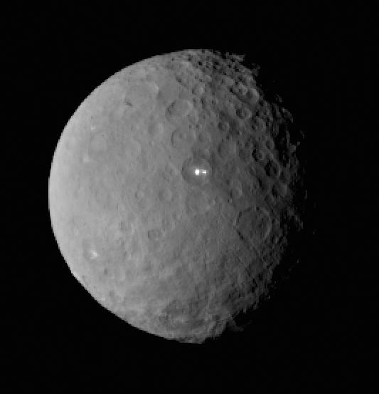
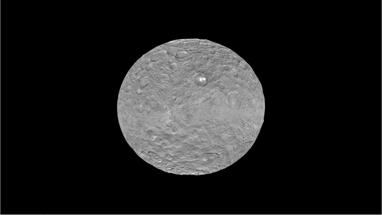
This image was taken by NASA’s Dawn spacecraft of dwarf planet Ceres on Feb. 19 from a distance of nearly 29,000 miles (46,000 kilometers). It shows that the brightest spot on Ceres has a dimmer companion, which apparently lies in the same basin. Image Credit: NASA/JPL-Caltech/UCLA/MPS/DLR/IDA
What is the teams reaction, interplay and interpretation regarding the mountains of new data being received from Dawn? How do the geologic processes compare to Earth?
“Dawn has transformed what was so recently a few bright dots into a complex and beautiful, gleaming landscape,” says Rayman. “Soon, the scientific analysis will reveal the geological and chemical nature of this mysterious and mesmerizing extraterrestrial scenery.”
“We do believe we see geologic processes analogous to those on Earth – but with important Cerean twists,” Russell told me.
“However we are at a point in the mission where conservative scientists are interpreting what we see in terms of familiar processes. And the free thinkers are imagining wild scenarios for what they see.”
“The next few weeks (months?) will be a time where the team argues amongst themselves and finds the proper compromise between tradition and innovation,” Russell concluded elegantly.
Among the highest features seen on Ceres so far is a mountain about 4 miles (6 kilometers) high, which is roughly the elevation of Mount McKinley in Alaska’s Denali National Park. Vertical relief has been exaggerated by a factor of five to help understand the topography. Credits: NASA/JPL-Caltech/UCLA/MPS/DLR/IDA/LPI
A batch of new results from Dawn at Ceres are expected to be released during science presentations at the European Planetary Science Congress 2015 being held in Nantes, France from 27 September to 2 October 2015.
The Dawn mission is expected to last until at least March 2016, and possibly longer, depending upon fuel reserves.
“It will end some time between March and December,” Rayman told me.
The science objectives in the LAMO orbit could be achieved as soon as March. But the team wants to extend operations as long as possible, perhaps to June or beyond, if the spacecraft remains healthy and has sufficient hydrazine maneuvering fuel and NASA funding to operate.
“We expect Dawn to complete the mission objectives at Ceres by March 2016. June is a the programmatic milestone for end of the nominal mission, effectively a time margin,” Makowski told Universe Today.
“The team is working to a well-defined exploration plan for Ceres, which we expect to accomplish by March, if all goes well.”
“At launch Dawn started with 45 kg of hydrazine. It has about 21 kg of usable hydrazine onboard as of today.”
“We expect to use about 15 kg during the nominal remaining mission,” Makowski stated.
Therefore Dawn may have roughly 5 kg or so of hydrazine fuel for any extended mission, if all goes well, that may eventually be approved by NASA. Of course NASA’s budget depends also on what is approved by the US Congress.
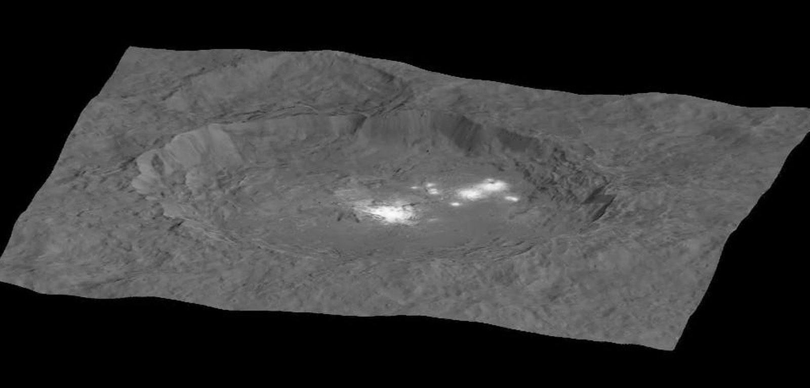
The intriguing brightest spots on Ceres lie in a crater named Occator, which is about 60 miles (90 kilometers) across and 2 miles (4 kilometers) deep. Vertical relief has been exaggerated by a factor of five. Exaggerating the relief helps scientists understand and visualize the topography much more easily, and highlights features that are sometimes subtle. Credits: NASA/JPL-Caltech/UCLA/MPS/DLR/IDA/LPI
Dawn was launched on September 27, 2007 by a United Launch Alliance (ULA) Delta II Heavy rocket from Space Launch Complex-17B (SLC-17B) at Cape Canaveral Air Force Station, Florida.
Stay tuned here for Ken’s continuing Earth and planetary science and human spaceflight news.
Dawn launch on September 27, 2007 by a United Launch Alliance Delta II Heavy rocket from Cape Canaveral Air Force Station, Florida. Credit: Ken Kremer/kenkremer.com
The intriguing brightest spots on Ceres lie in a crater named Occator, which is about 60 miles (90 kilometers) across and 2 miles (4 kilometers) deep. Vertical relief has been exaggerated by a factor of five. Exaggerating the relief helps scientists understand and visualize the topography much more easily, and highlights features that are sometimes subtle. Credits: NASA/JPL-Caltech/UCLA/MPS/DLR/IDA/LPI
Video caption: Take a tour of weird Ceres! Visit a 2-mile-deep crater and a 4-mile-tall mountain in the video narrated by mission director Marc Rayman. Get your red/blue glasses ready for the finale – a global view of the dwarf planet in 3D. Credits: NASA/JPL-Caltech/UCLA/MPS/DLR/IDA/LPI/PSI
Mysterious bright spots and a pyramidal shaped mountain star in a daunting new flyover video of dwarf planet Ceres created from imagery gathered by NASA’s history making Dawn mission – the first ever to visit any dwarf planet which simultaneously ranks as the largest world in the main asteroid belt residing between Mars and Jupiter.
Ceres was nothing more than a fuzzy blob to humankinds most powerful telescopes like the Hubble Space Telescope (HST), until the probe swooped in this year and achieved orbit on March 6, 2015.
The newly released, stunning video takes takes you on a tour like none before for a global cruise over the most fascinating features on Ceres – including the 2-mile-deep (4-km-deep) crater dubbed Occator and a towering 4-mile-tall (6 kilometer-tall) mountain as tall as any in North America.
The spectacular flyover animation was generated from high resolution images taken by Dawn’s framing camera during April and May and is narrated by Marc Rayman, Dawn Chief Engineer and Mission Director of NASA’s Jet Propulsion Laboratory, Pasadena, California.
The video concludes with a 3D view, so you’ll need to whip out your handy red/blue glasses for the finale – a global view of the dwarf planet in 3D.
From the orbital altitude at that time ranging from about 8,400 miles (13,600 kilometers) to 2,700 miles (4,400 kilometers), the highest-resolution regions on Ceres have a resolution of 1,600 feet (480 meters) per pixel.
Pockmarked Ceres is an alien world unlike any other in our solar system, replete with unexplained bright spots and craters of many sizes, large and small.
Occatur has captured popular fascination world-wide because the 60 miles (90 kilometers) diameter crater is rife with a host of the bodies brightest spots and whose nature remains elusive to this day, nearly half a year after Dawn arrived in orbit this past spring.
“Now, after a journey of 3.1 billion miles (4.9 billion kilometers) and 7.5 years, Dawn calls Ceres, home,” says Rayman.
The crater is named after the Roman agriculture deity of harrowing, a method of pulverizing and smoothing soil.
Dawn is an international science mission managed by NASA and equipped with a trio of science instruments from the US, Germany and Italy. The framing camera was provided by the Max Planck Institute for Solar System Research, Göttingen, Germany and the German Aerospace Center (DLR).
The visible and infrared mapping spectrometer (VIR), provided by Italy is an imaging spectrometer that examines Ceres in visible and infrared light.
Dawn’s science team is using the instruments to investigate the light reflecting from Occator at different wavelengths.
From a distance, the crater appeared to be home to a duo of bright spots that looked like a pair of eyes. As Dawn moves ever closer, they became more resolved and now are split into dozens of smaller bright spots.
Global view of Ceres uses data collected by NASA’s Dawn mission in April and May 2015. The highest-resolution parts of the map have a resolution of 1,600 feet (480 meters) per pixel. Credits: NASA/JPL-Caltech/UCLA/MPS/DLR/IDA/LPI/PSI
Although some early speculation centered on the spots possibly being consistent with water ice or salts, newly gathered data “has not found evidence that is consistent with ice. The spots’ albedo -¬ a measure of the amount of light reflected -¬ is also lower than predictions for concentrations of ice at the surface,” according to the scientists.
“The science team is continuing to evaluate the data and discuss theories about these bright spots at Occator,” said Chris Russell, Dawn’s principal investigator at the University of California, Los Angeles, in a statement.
“We are now comparing the spots with the reflective properties of salt, but we are still puzzled by their source. We look forward to new, higher-resolution data from the mission’s next orbital phase.”
Occator lies in Ceres northern hemisphere.
The huge pyramidal mountain lies farther to the southeast of Occator – at 11 degrees south, 316 degrees east.
Based on the latest calculations, the mountain sits about 4 miles (6 kilometers) high, with respect to the surface around it. That make it roughly the same elevation as Mount McKinley in Denali National Park, Alaska, the highest point in North America.
Among the highest features seen on Ceres so far is a mountain about 4 miles (6 kilometers) high, which is roughly the elevation of Mount McKinley in Alaska’s Denali National Park. Vertical relief has been exaggerated by a factor of five to help understand the topography. Credits: NASA/JPL-Caltech/UCLA/MPS/DLR/IDA/LPI
The Texas-sized world is slightly smaller than previously thought. Based on new measurements from Dawn, Ceres’ average diameter to 584 miles (940 kilometers), compared to earlier estimates of 590 miles (950 kilometers).
Dawn made history in March when it simultaneously became the first probe from Earth to reach Ceres as well as the first spacecraft to orbit two extraterrestrial bodies.
It had previously visited Vesta. After achieving orbit in July 2011, Dawn became the first spacecraft from Earth to orbit a body in the main Asteroid Belt.
In sharp contrast to rocky Vesta, Ceres is an icy world.
Scientists believe that Ceres may harbor an ocean of subsurface liquid water as large in volume as the oceans of Earth below a thick icy mantle despite its small size – and thus could be a potential abode for life. Overall Ceres is estimated to be about 25% water by mass.
“We really appreciate the interest in our mission and hope they are as excited as we have been about these scientific surprises,” Russell told Universe Today.
“Since we are only just beginning our investigation, I expect that there will be more surprises. So please stick with us!”
As Dawn spirals down to a lower orbit of about 1,200 miles (1,900 km) above Ceres (and then even lower) using its ion engines, new answers and new mysteries are sure to be forthcoming.
“There are many other features that we are interested in studying further,” said Dawn science team member David O’Brien, with the Planetary Science Institute, Tucson, Arizona.
“These include a pair of large impact basins called Urvara and Yalode in the southern hemisphere, which have numerous cracks extending away from them, and the large impact basin Kerwan, whose center is just south of the equator.”
The mission is expected to last until at least June 2016 depending upon fuel reserves.
Dawn was launched on September 27, 2007 by a United Launch Alliance (ULA) Delta II Heavy rocket from Space Launch Complex-17B (SLC-17B) at Cape Canaveral Air Force Station, Florida.
Stay tuned here for Ken’s continuing Earth and planetary science and human spaceflight news.