Cassini Data Has Revealed a Towering Hexagonal Storm at Saturn’s Northern Pole

A new study based on data from the Cassini mission is revealing something surprising in the atmosphere of Saturn. We’ve known about the storm at the gas giant’s north pole for decades, but now it appears that this massive hexagonal storm could be a towering behemoth hundreds of kilometers in height that has its base deep in Saturn’s atmosphere.

This grey-scale image of Saturn’s northern polar vortex was captured by the Cassini spacecraft. This image was captured from a distance of about 1.2 million km. A portion of Saturn’s rings are barely visible in the top right. Image: NASA/JPL-Caltech/Space Science Institute.

Continue reading “Cassini Data Has Revealed a Towering Hexagonal Storm at Saturn’s Northern Pole”

Zoom to the Moon’s North Pole with this Incredible New Gigapixel Map

A new interactive mosaic from NASA's Lunar Reconnaissance Orbiter covers the north pole of the moon from 60 to 90 degrees north latitude at a resolution of 6-1/2 feet (2 meters) per pixel. Close-ups of Thales crater (right side) zoom in to reveal increasing levels of detail. Image Credit: NASA/GSFC/Arizona State University

OMG – breathtaking! That was my reaction when I clicked on this incredible new interactive map of the moon’s north polar region. Be prepared to be amazed. It took four years and 10,581 images for the LROC (Lunar Reconnaissance Orbiter Camera) team to assemble what’s believed to be the largest publicly available image mosaic in existence. With over 650 gigapixels of data at a resolution of 2 meters per pixel, you’ll feel like you’re dropping in by parachute  to the lunar surface. 

The 91-km Karpinskiy Crater from the new interactive north pole mosaic. See image below for a zoomed-in view. Credit: NASA
Wide view of the 91-km Karpinskiy Crater from the new interactive north pole mosaic. See image below for a zoomed-in view. Credit: NASA/GSFC/Arizona State Univ.

When you call up the map, be sure to click first on the full-screen button below the zoom slider. Now you’re ready for the full experience. With mouse in hand, you’re free to zoom and pan as you please. Take in the view of Whipple Crater shadowed in polar darkeness or zoom to the bottom of Karpinskiy Crater and fly like a bird over its fractured floor.

In this photo, we come in for a closer look at the fracture or rill in Karpinskiy's floor. Notice the boulders on the cliff side. Credit: NASA
In this photo, we come in for a closer look at the fracture or rill in Karpinskiy’s floor. Notice the small, lighter-toned boulders on the cliff side. The images were all taken with the Lunar Reconnaissance Orbiter’s Narrow Angle Camera (NAC).  Credit: NASA/GFSC/Arizona State Univ.

The images are so detailed and the zoom so smooth, there’s nothing artificial about the ride. Except the fact you’re not actually orbit. Darn close though. All the pictures were taken over the past few years by NASA’s Lunar Reconnaissance Orbiter which can fly as low as 50 km (31 miles) over the lunar surface and resolve details the size of a desk.

Printed at 300 dpi (a high-quality printing resolution that requires you to peer very closely to distinguish pixels), the LNPM would be larger than a football field. Credit: NASA
Printed at 300 dpi – a high-quality printing resolution that requires you to peer very closely to distinguish pixels –  the mosaic map would be larger than a football field. Credit: NASA

There are 10 snapshots along the bottom of the map – click them and you’ll be swiftly carried directly to that feature. One of them is the lunar gravity probe GRAIL-B impact site.

The region the gigapixel map covers superimposed on the outline of the U.S. Credit: NASA

To create the 2-D map, a polar stereographic projection was used in to limit mapping distortions. In addition, the LROC team used information from the LOLA and GRAIL teams and an improved camera pointing model to accurately project each image in the mosaic to within 20 meters. For more information on the project, click HERE.

OK, I’ve said enough. Now go take a look!

Why the North Pole Is Really a South Pole (and Vice Versa)

If you go out hiking this weekend and somehow find yourself hopelessly lost in the wilderness, but suddenly remember you have a compass with you, you can use it to find north because the needle always points towards the Earth’s geographic north pole, which never changes… right?

Wrong, wrong, and wrong. And this video from MinutePhysics explains why.

(But still bring a compass with you. They do come in handy.)

See more videos from MinutePhysics here.

Incredible Raw Image of Saturn’s Swirling North Pole

Ok, are you ready for this?

I know… WOW.

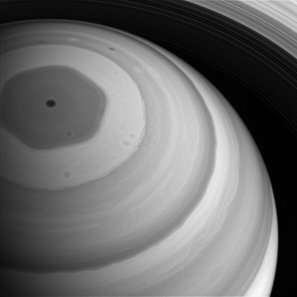
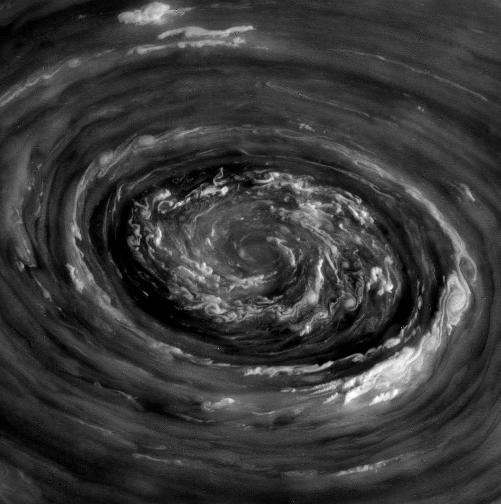
This swirling maelstrom of clouds is what was seen over Saturn’s north pole earlier today, November 27, by NASA’s Cassini spacecraft. This is a raw image, acquired in polarized light, from a distance of 238,045 miles (383,097 kilometers)… all I did was remove some of the hot pixels that are commonly found on Cassini images taken with longer exposures.

Again… WOW.

My attempt at a color composite can be seen below, plus another treat:

It’s rough, and a little muddy because the clouds were moving between image channels (not to mention the blue channel image was rather underexposed) but here’s a color-composite of the same feature, made from images taken from a slightly different perspective:

Color composite of Saturn’s north polar vortex

Pretty darn cool… Cassini does it yet again!

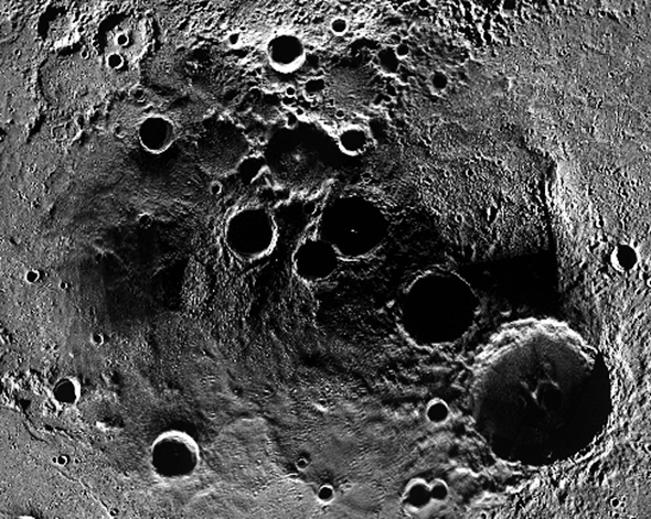
The images above show an approximately 3,000-4,000-km-wide cyclone above Saturn’s north pole. Saturn is also known to have a long-lived hexagonal jet stream feature around its north pole as well, but that is not shown in those images as it runs along a lower latitude. Instead, you can see that HERE:

Saturn’s northern hexagon

Captured with a wider angle, in this image the hexagon structure can be made out as well as the cyclone, which sits at the center just over the pole. Saturn’s hexagon is about 25,000 km (15,500 miles) in diameter… large enough to fit almost four Earths inside. This image was also acquired today.

An RGB composite of this feature is below:

Saturn’s northern hexagon – color composite

It’s been a few years since we’ve gotten such a good look at Saturn’s north pole… thanks to Cassini’s new orbital trajectory, which is taking it high above the ring plane and poles of Saturn, we now have the opportunity to view the gas giant’s dynamic upper latitudes again. I’m sure this is just a taste of what’s to come!

(Image credit: NASA/JPL/Space Science Institute. Color composites by Jason Major)

Lighting Up Mercury’s Shadowy North Pole

Part of a stereographic projection of Mercury’s north pole

Talk about northern exposure! This is a section of a much larger image, released today by the MESSENGER team, showing the heavily-cratered north pole of Mercury as seen by the MESSENGER spacecraft’s Mercury Dual Imaging System (MDIS) instrument.

See the full-size image below:

Many MDIS images were averaged together to create a mosaic of Mercury’s polar region, which this stereographic projection is centered on. MESSENGER is at its lowest altitude as it passes over Mercury’s northern hemisphere — about  200 kilometers (124 miles), which is just a little over half the altitude of the ISS.

The largest centrally-peaked crater near the center is Prokofiev, named after a 20th-century Russian composer. Approximately 110 km (68 mi.) in diameter, its permanently-shadowed interior is home to radar-bright deposits that are thought to contain water ice.

Even though Mercury is almost three times closer to the Sun than Earth is and hosts searing daytime temperatures of 425ºC (800ºF), there’s virtually no atmosphere to hold or transmit that heat. Nighttime temperatures can reach as low as -185ºC (-300ºF), and since a day on Mercury is 176 Earth days long it gets very cold for quite a long time!

Also, because Mercury’s axis of rotation isn’t tilted like Earth’s, low elevation areas near the poles receive literally no sunlight. Unless vaporized by a meteorite impact any ice gathered inside these deep craters would remain permanently frozen.

Here’s an orthographic projection of the image above, showing what the scene would look like on Mercury — that is, if it was ever fully lit by the Sun, which it isn’t.

Many of the craters on Mercury’s north pole have recently been named after famous artists, authors and composers, such as Kandinsky, Stieglitz, Goethe, and even one named after J.R.R. Tolkien. You can see an annotated image showing the names of Mercury’s north polar craters here.

Read More: “The Hobbit” Author Gets a Crater on Mercury

On November 29, NASA will host a news conference at 2 p.m. EST to reveal new observations from MESSENGER, the first spacecraft to orbit Mercury. The news conference will be carried live on NASA Television and the agency’s website… you can tune in on NASA TV here. 

Image credits: NASA/Johns Hopkins University Applied Physics Laboratory/Carnegie Institution of Washington

Magnetic North Pole

The movement of Earth's north magnetic pole across the Canadian arctic, 1831--2001 (Geological Survey of Canada)

[/caption]

The Earth has a magnetic field, known as the magnetosphere, that protects our planet from the particles of the solar winds. One point of that field is known as the Magnetic North Pole. The Magnetic North Pole is not the geographic North Pole; it is actually hundreds of miles south of the geographic North Pole and north of Canada.

Hundreds of years ago, European navigators believed that the needles of compasses were attracted to some “magnetic mountain” or “island” thought to be located in the far north. Some also believed that the needles could be attracted to the Pole Star, which is part of the Ursa Minor constellation and has long been used in navigation. One English philosopher, William Gilbert, proposed that the Earth acts like a giant magnet; he also was the first person to state that the Earth’s magnetic field points vertically downward at the Magnetic North Pole. It took hundreds of years before scientists came to properly understand our planet’s magnetic field, although this is known to be correct now.

All magnets have two poles, like the “plus” and “minus” signs found on batteries. Instead of these locations being named plus and minus though, they were named the North and South Magnetic Poles. It is toward the Magnetic North Pole that your compass points not the geographic North Pole, which makes sense considering it utilizes magnets to determine direction. At the Magnetic North Pole, the magnetic fields points down vertically; in other words it has a 90° “dip” toward the Earth’s surface. The counterpart of the Magnetic North Pole is the Magnetic South Pole. Because the Earth’s magnetic field is not perfectly symmetrical, the magnetic fields are not antipodal. That means that if you draw a straight line between them, it does not pass through the Earth’s center. It is off by approximately 530 km. The North and South Magnetic Poles are also known as Magnetic Dip Poles because they “dip” at a 90° angle towards the Earth.   

The Magnetic North Pole continues to move around. According to the Geological Survey of Canada, which routinely studies the Magnetic North Pole, the pole moves as much as 40 km per year. It also moves daily. Every day, the Magnetic North Pole has an elliptical movement of approximately 80 km from the average point of its center. That means when you are using a compass, you have to be aware of the difference between magnetic north and geographic north.

Universe Today has articles on Earth’s magnetic field and modeling the Earth’s magnetic field.

For more information, check out the Magnetic North Pole and geomagnetism.

Astronomy Cast has an episode on Earth.

References:
Earth’s Inconstant Magnetic Field
Earth’s Magnetic Field and its Changes in Time