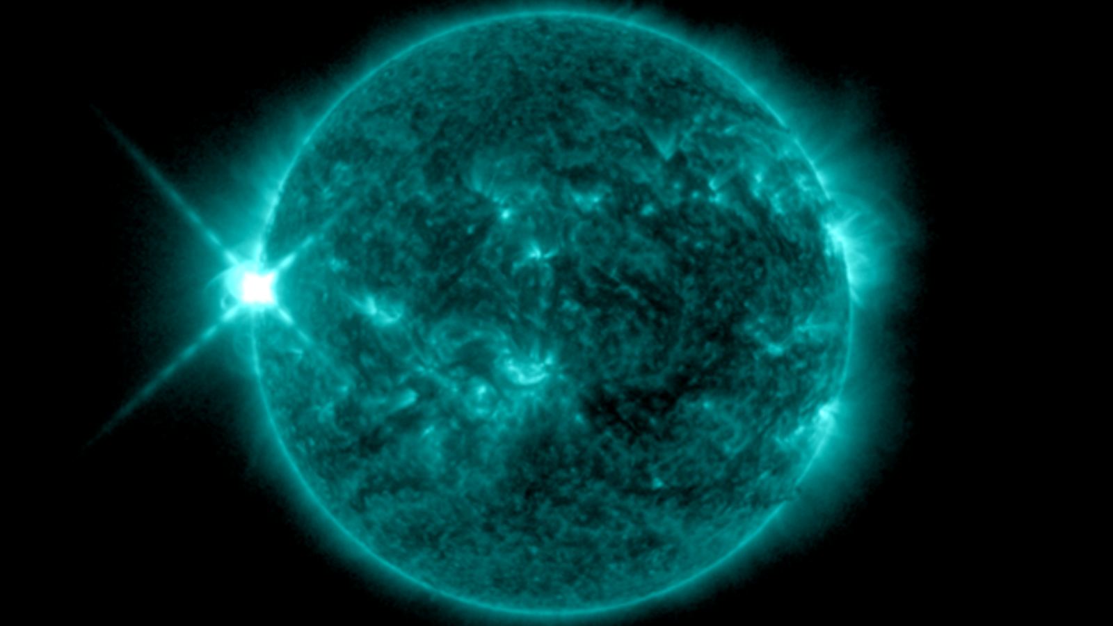
While many of us were celebrating the end of 2023 and the coming of 2024, the Sun was having its own celebration blasting an X5.0 flare from sunspot region 3536. Records show this to be the most powerful flare seen since 10 September 2017 when an X8.2 flare erupted. The flare is expected to arrive around Jan 2 – EEK that’s today! Get your aurora watching kit out!
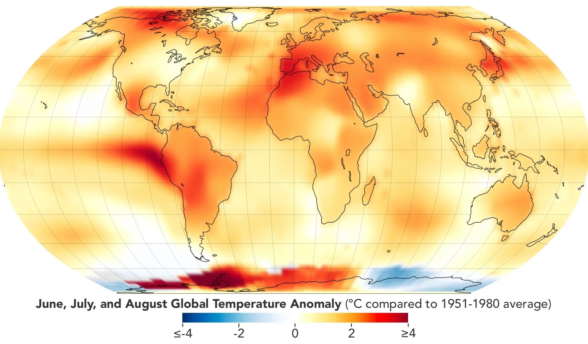
This map depicts global temperature anomalies for meteorological summer in 2023 (June, July, and August). It shows how much warmer or cooler different regions of Earth were compared to the baseline average from 1951 to 1980. Credit: NASA's Earth Observatory/Lauren Dauphin
Yesterday, NASA’s Goddard Institute of Space Studies (GISS) announced that the summer of 2003 was the hottest on record. This year saw a massive heat wave that swept across much of the world and was felt in South America, Japan, Europe, and the U.S. This exacerbated deadly wildfires in Canada and Hawaii (predominantly on the island of Maui) and are likely to have contributed to severe rainfall in Italy, Greece, and Central Europe. This is the latest in a string of record-setting summers that are the direct result of anthropogenic climate change.
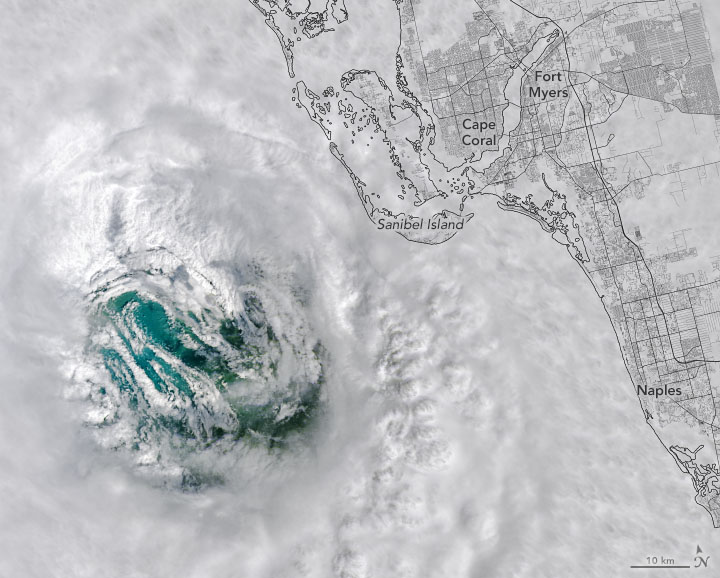
On September 28, the Landsat 8 satellite passed directly over Ian’s eye as the storm approached southwest Florida. Credit: US Geological Survey.
NASA and NOAA satellites — as well as astronauts on the ISS — captured some stunning imagery of Hurricane Ian, as seen from orbit. Our lead image shows an eerie view of the hurricane’s eye on September 28. The Landsat 8 satellite passed directly over Ian’s eye as the storm approached southwest Florida.
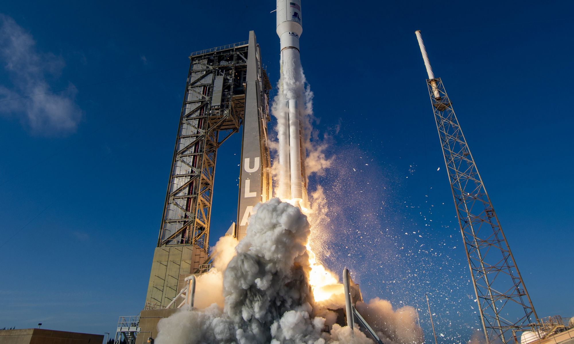
A United Launch Alliance (ULA) Atlas V rocket carrying NOAA's GOES-T satellite, launching for NASA's Launch Services Program, lifts off from from Space Launch Complex-41 at 4:38 p.m. EST on March 1, 2022. Photo Credit: United Launch Alliance
NASA and NOAA now have a sophisticated new weather satellite in space. The GOES-T satellite launched on the powerful United Launch Alliance (ULA) Atlas V rocket on March 1, and it will provide forecasters with high resolution weather imagery. It will also provide real-time monitoring of events on the ground like wildfires, floods and landslides, while monitoring atmospheric and climate dynamics over the Western US and Pacific Ocean.
The liftoff from Cape Canaveral Space Force Station of GOES-T (Geostationary Operational Environmental Satellite-T) provided stunning views, and incredibly, other satellites looked down and captured the launch of the new satellite from space, such as this shot from its older sibling, GOES-16:
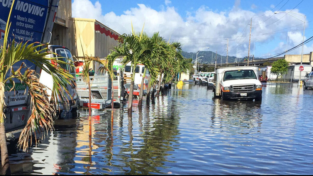
High-tide flooding in Honolulu. Credit: Hawaii Sea Grant King Tides Project
Planet Earth is currently experiencing an unprecedented warming trend. Average global temperatures are rising at an accelerated rate in response to greenhouse gas emissions produced by human activity. These rising temperatures, in turn, result in the release of additional greenhouse gases (like methane), leading to positive feedback loops that threaten to compound the problem further.
This scientific consensus is based on multiple lines of evidence, all of which indicate the need for swift action. According to new research led by members of the NASA Sea Level Change Science Team (N-SLCT) at the University of Hawaii at Manao (UHM), a new Lunar cycle that will begin by the mid-2030s will amplify sea levels already rising due to climate change. This will mean even more coastal flooding during high tides and coastal storms in the near future.
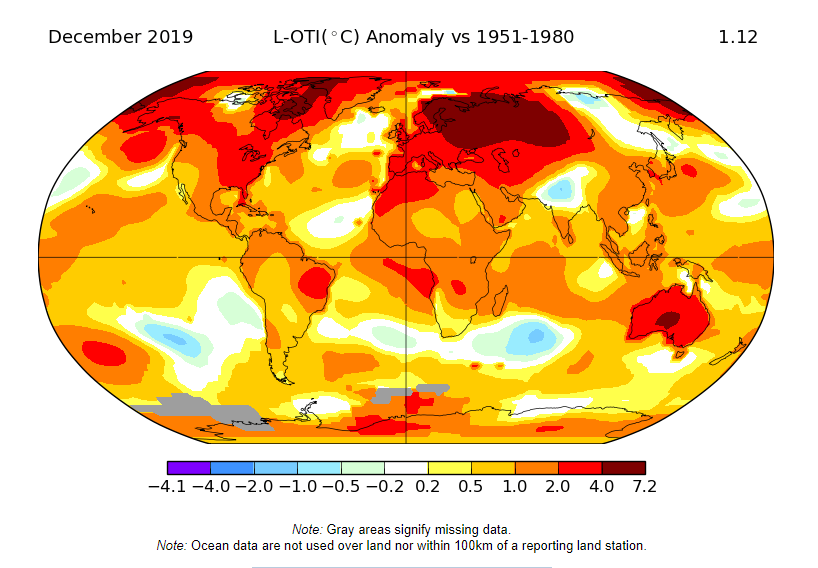
According to NASA and the NOAA, 2019 was the second hottest year on record. Image Credit: NASA/GISS
NASA and the NOAA just announced that 2019 was the second hottest year on record. It barely edged out 2016, the previous warmest year. And both 2019 and 2016 are part of the global warming trend: the last five years have been the warmest five years on record. And the last decade was the warmest decade.
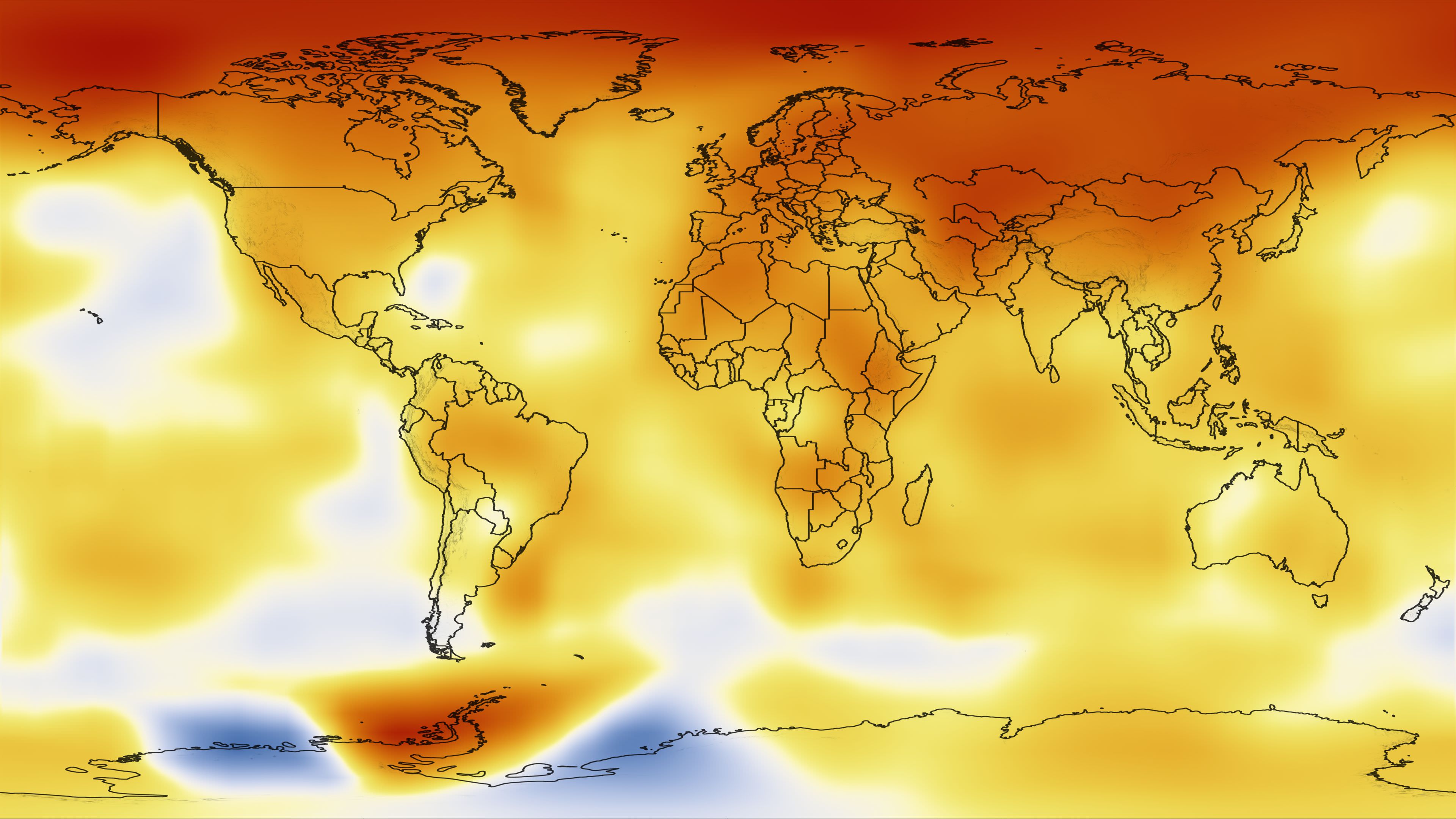
The map shows temperature changes for the last decade—January 2000 to December 2009—relative to the 1951-1980 mean. Credit: NASA
There are a handful of major science institutions around the world that keep track of the Earth’s temperature. They all clearly show that the world’s temperature has risen in the past few decades. One of those institutions is NASA.
GOES-17 took this stunning, full-disk snapshot of Earth’s Western Hemisphere from its checkout position at 12:00 p.m. EDT on May 20, 2018, using the Advanced Baseline Imager (ABI) instrument. GOES-17 observes Earth from an equatorial vantage point approximately 22,300 miles above the surface. Credit: NOAA/NASA
The purpose of this new generation of satellites is to improve the forecasts of weather, oceans, the environment and space weather by providing faster and more detailed data, real-time images, and advanced monitoring. Recently, the satellite’s Advanced Baseline Imager (ABI) made its debut by releasing its “first light“, which just happened to be some beautiful and breathtaking images of Earth from space.
The image featured above was taken on May 20th, 2018, where GOES-17 captured the sunset over Earth’s Western Hemisphere. This image was taken when the satellite was at a distance of 35,405 km (22,000 miles) from Earth and was presented in “GeoColor”, which captures features of the Earth’s surface and atmosphere in vivid detail and colors that are familiar to the human eye.
Compared to previous GOES satellites, GOES-17 can collect three times more data at four times the image resolution, and scan the planet five times faster than previous probes. These abilities were put to the test as the ABI created its beautiful images of Earth using two visible bands (blue and red) and one near-infrared “vegetation” band, and one of the ABI’s “longwave” infrared bands.
When combined as a “GeoColor” image, these bands provide valuable information for monitoring dust, haze, smoke, fog, clouds and winds in the atmosphere – which allows meteorologists to monitor and forecast where severe weather events will take place. It also allows scientists to monitor vegetation patterns to see how weather conditions can lead to increased drought or the expansions of greenery.
It also results in pictures depicting Earth in vivid and colorful detail, as you can plainly see! The satellite is currently in its post-launch checkout testing phase, where controllers on Earth are busy calibrating its instruments and systems and validating them for use. The imagery acquired by the ABI is one such example, which served as a preliminary check to ensure that the imaging instrument will function properly.
Other images included the picture of a series of dynamic marine stratocumulus clouds (shown above), which was captured by the satellite’s ABI off the western coast of Chile in the the southeastern Pacific Ocean. Once again, the improved resolution and sensitivity of the GOES-17 allows it to monitor clouds in our atmosphere with amazing detail and clarity.
GOES-17 also captured a deck of low level stratus clouds covering the southern California coast (above) and smoke plumes created by wildfires in central and northern Saskatchewan, Canada (below). These two images were also acquired by the ABI on May 20th, 2018, and demonstrate how effective GOES-17 will be when it comes to monitoring weather patterns, events that can trigger fires (i.e. lighting), and the resulting fires themselves.
Alongside GOES-17, NOAA’s operational geostationary constellation also consists of GOES-16 (operating as GOES-East), GOES-15 (operating as GOES-West), and GOES-14 – operating as the on-orbit spare. This satellite constellation is currently in good working order and is monitoring weather across the US and the planet each day.
While this data is still preliminary and non-operational, it does provide a good preview of what the GOES-17 can do. In the coming years, it and its third and fourth-generation cousins – GOES-T and GOES-U – will allow Earth observers to monitor weather, climate change and natural disasters with far greater detail, allowing for better early warning and response efforts.
To see more full-resolution images from the GOES-17 ABI, go to the NOAA page.
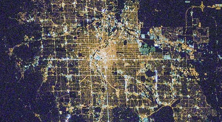
The city of Denver, Colorado, as seen from space. Credit: NASA
When it comes to technology and the environment, it often seems like it’s “one step forward, two steps back.” Basically, sometimes the new and innovative technologies that are intended correct for one set of problems inevitably lead to new ones. This appears to be the case with the transition to solid-state lighting technology, aka. the “lighting revolution”.
Basically, as nations transition from traditional lights to the energy-saving Light-Emitting Diodes (LEDs), there is the potential for a rebound effect. According to an international study led by Christopher Kyba from the GFZ German Research Center for Geoscience, the widespread use of LED lights could mean more usage and more light pollution, thus counter-acting their economic and environmental benefits.
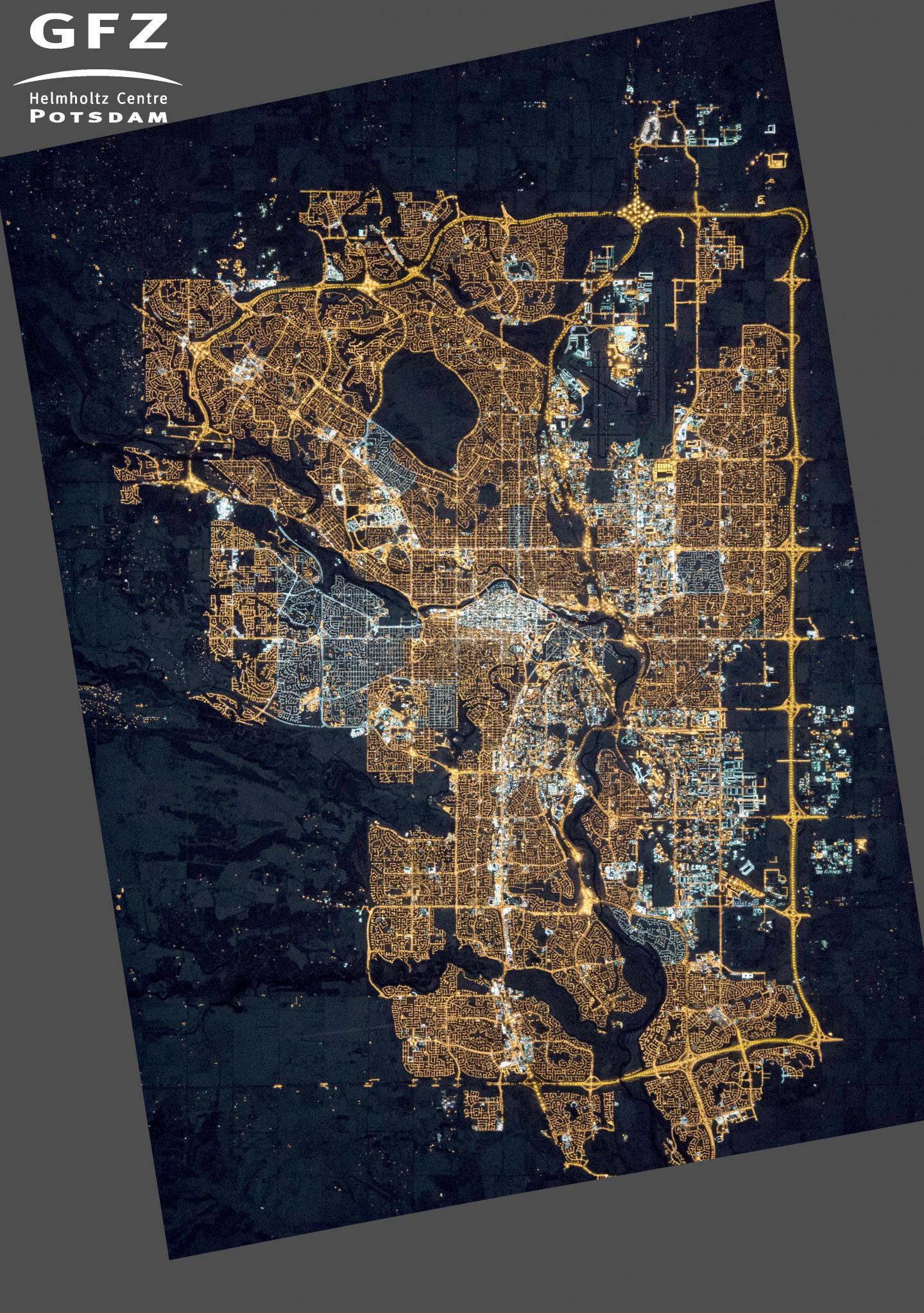
Photograph of Calgary, Alberta, Canada, taken from the International Space Station on Nov. 27th, 2015. Credit: NASA’s Earth Observatory/Kyba, GFZ
To put it simply, the cost-saving effects of LED lights make them attractive from a consumer standpoint. From an environmental standpoint, they are also attractive because they reduce our carbon footprint. Unfortunately, as more people are using them for residential, commercial and industrial purposes, overall energy consumption appears to be going up instead of down, leading to an increased environmental impact.
For the sake of their study, the team relied on satellite radiometer data calibrated for nightlights collected by the Visible/Infrared Imager Radiometer Suite (VIIRS), an instrument on the NOAA’s Suomi-NPP satellite that has been monitoring Earth since October of 2011. After examining data obtained between 2012 and 2016, the team noted a discernible increase in power consumption associated with LED use. As they explain in their study:
“[F]rom 2012 to 2016, Earth’s artificially lit outdoor area grew by 2.2% per year, with a total radiance growth of 1.8% per year. Continuously lit areas brightened at a rate of 2.2% per year. Large differences in national growth rates were observed, with lighting remaining stable or decreasing in only a few countries.”
This data is not consistent with energy reductions on a global scale, but rather an increase in light pollution. The increase corresponded to increases in the Gross Domestic Product (GDP) of the fastest-growing developing nations. Moreover, it was also found to be happening in developed nations. In all cases, increased power consumption and light pollution has natural consequences for plants, animals, and human well-being.
“The great hope was that LED lighting would lead to lower energy usage, but what we’re seeing is those savings being used for increased lighting. We’re not just seeing this in developing countries, but also in developed countries. For example, Britain is getting brighter. You now struggle to find anywhere in Europe with a natural night sky – without that sky glow we’re all familiar with.”
The team also compared the VIIRS data to photographs taken from the International Space Station (ISS) which showed that the Suomi-NPP satellite sometimes record a dimming of some cities. This is due to the fact that the sensor can’t pick up light at wavelengths below 500 nanometers (nm) – i.e. blue light. When cities replace orange lamps with white LEDs, they emit more radiation below 500 nm.
The effect of this is that cities that are at the same brightness or have experienced an increase in brightness may actually appear dimmer. In other words, even in cases where satellites are detecting less radiation coming from the surface, Earth’s night-time brightness is actually increasing. But before anyone gets to thinking that it’s all bad news, there is a ray of light (no pun!) to be found in this research.
In previous studies, Kyba has shown that light emissions per capita in the US are 3 to 5 times higher than that in Germany. As he indicated, this could be seen as a sign that prosperity and conservative light use can coexist:
“Other studies and the experience of cities like Tucson, Arizona, show that well designed LED lamps allow a two-third or more decrease of light emission without any noticeable effect for human perception. There is a potential for the solid state lighting revolution to save energy and reduce light pollution, but only if we don’t spend the savings on new light”.
Reducing humanity’s impact on Earth’s natural environment is challenging work; and in the end, many of the technologies we depend upon to reduce our footprint can have the opposite effect. However, if there’s one thing that can prevent this from continually happening, it’s research that helps us to identifies our bad habits (and fix them!)
Have you noticed that weather forecasting has gotten much better in the last few years? Thanks to weather satellites, weather stations, and better forecasting techniques. How do scientists predict the weather with any kind of accuracy days or even weeks in the future.
If you would like to join the Weekly Space Hangout Crew, visit their site here and sign up. They’re a great team who can help you join our online discussions!