An artist concept depicting one of NASA's twin Voyager spacecraft, humanity's farthest and longest-lived spacecraft.
Voyager 2 just lost contact with Earth while Voyager 1 is still reporting back. Credit: NASA/JPL-Caltech
It’s every space mission’s nightmare: losing contact with the spacecraft. In the best case, you recover it right away. Worst case, you never hear from your hardware again. On July 21, controllers lost contact with Voyager 2, out in the depths of space. Now they’re waiting for a reset to catch Voyager 2’s next message when it “phones home”. (Update: on August 2, NASA announced via its Twitter account that it has received a “heartbeat” carrier signal from the spacecraft.)
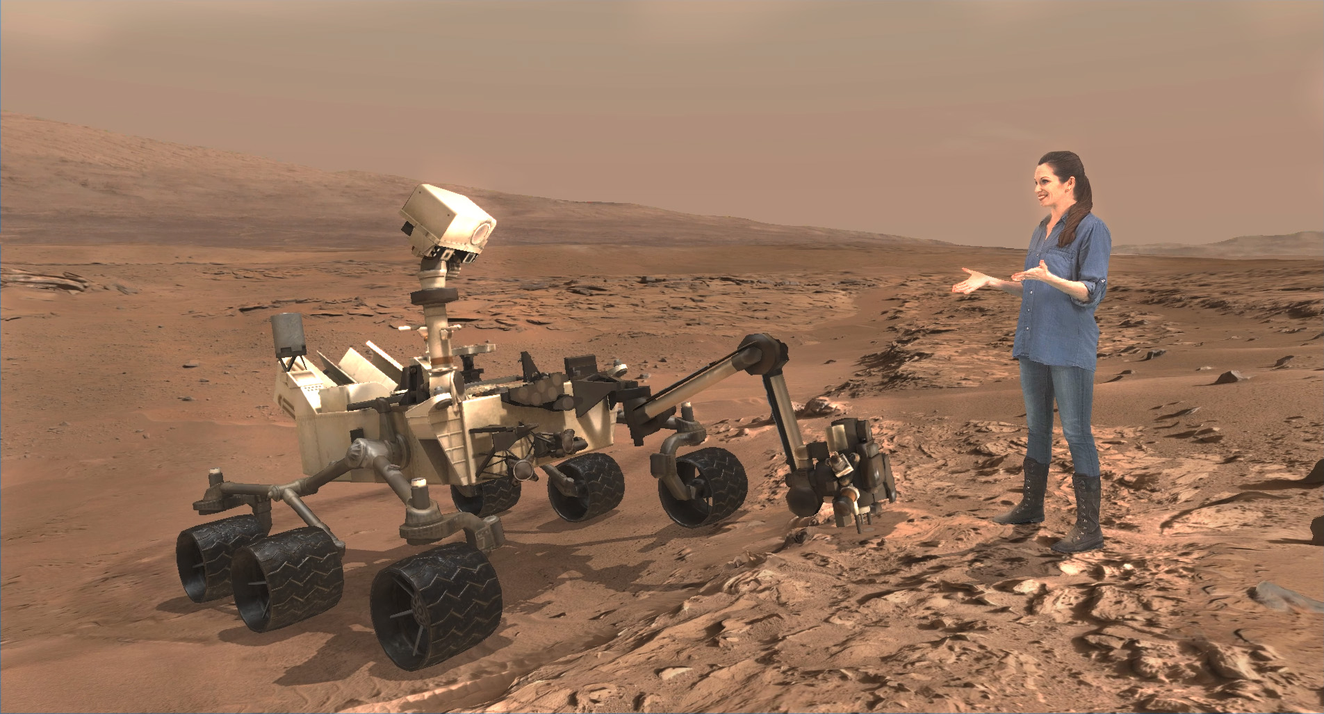
A scene from ‘Destination Mars’ of Buzz Aldrin and NASA’s Curiosity Mars rover with the Gale crater rim in the distance. The new, limited time interactive exhibit is now showing at the Kennedy Space Center visitor complex in Florida through Jan 1, 2017. Credit: NASA/JPL/Microsoft
A scene from ‘Destination Mars’ of Buzz Aldrin and NASA’s Curiosity Mars rover with the Gale crater rim in the distance. The new, limited time interactive exhibit is now showing at the Kennedy Space Center visitor complex in Florida through Jan 1, 2017. Credit: NASA/JPL/Microsoft
KENNEDY SPACE CENTER VISITOR COMPLEX, FL- Think a Holodeck adventure on Star Trek guided by real life Apollo 11 moonwalker Buzz Aldrin and you’ll get a really good idea of what’s in store for you as you explore the surface of Mars like never before in the immersive new ‘Destination Mars’ interactive holographic exhibit opening to the public today, Monday, Sept.19, at the Kennedy Space Center visitor complex in Florida.
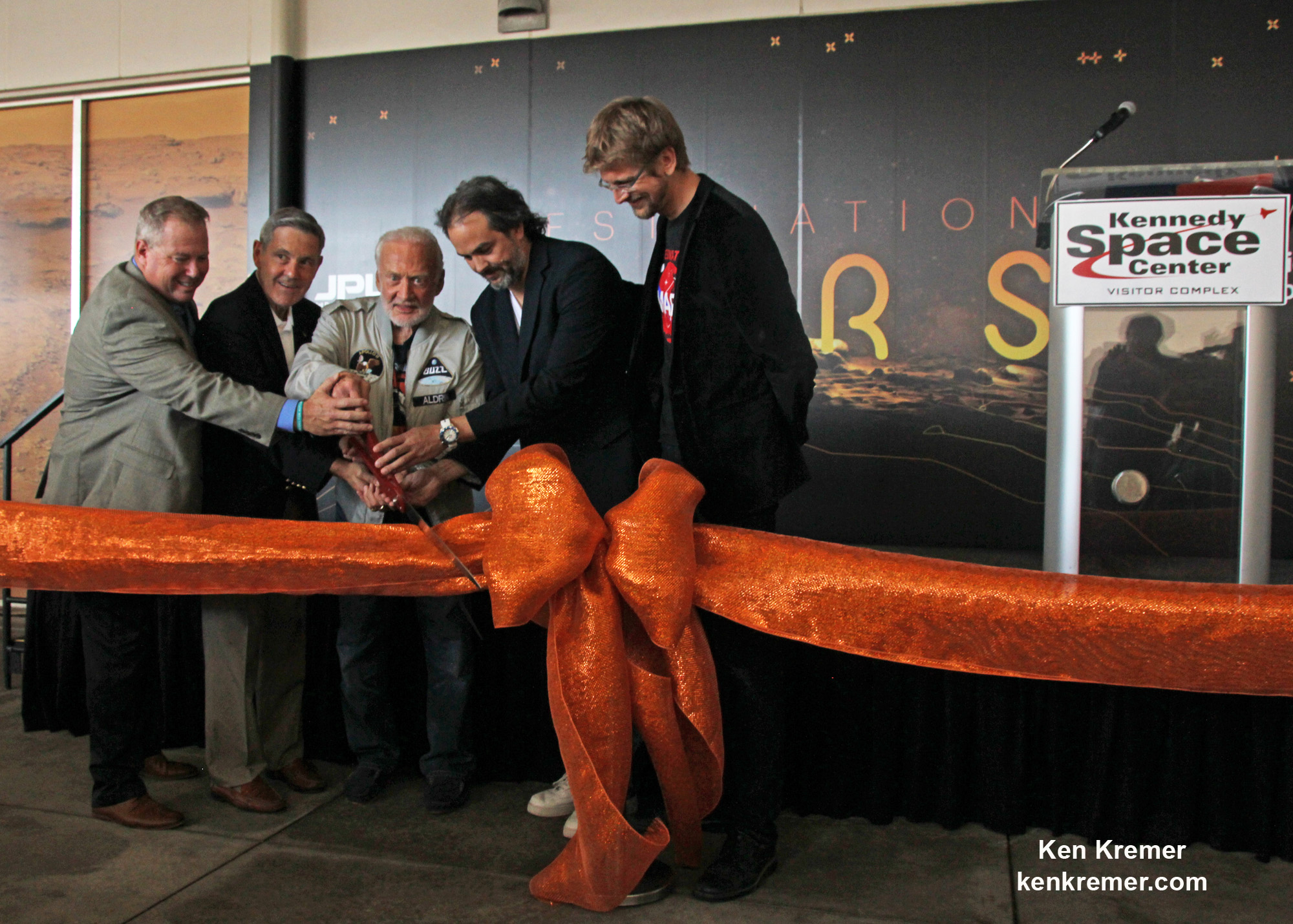
The new Red Planet exhibit was formally opened for business during a very special ribbon cutting ceremony featuring Buzz Aldrin as the star attraction – deftly maneuvering the huge ceremonial scissors during an in depth media preview and briefing on Sunday, Sept. 18, 2016, including Universe Today.
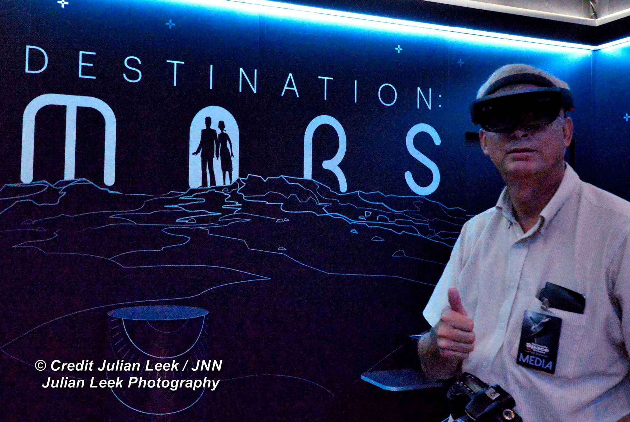
The fabulous new ‘Destination Mars’ limited engagement exhibit magically transports you to the surface of the Red Planet via Microsoft HoloLens technology.
It literally allows you to ‘Walk on Mars’ using real imagery taken by NASA’s Mars Curiosity rover and explore the alien terrain, just like real life scientists on a geology research expedition.
A ceremonial ribbon is cut for the opening of new “Destination: Mars” experience at the Kennedy Space Center visitor complex in Florida during media preview on Sept. 18, 2016. From the left are Therrin Protze, chief operating officer of the visitor complex; center director Bob Cabana; Apollo 11 astronaut Buzz Aldrin; Kudo Tsunoda of Microsoft; and Jeff Norris of NASA’s Jet Propulsion Laboratory in Pasadena, California. Credit: Ken Kremer/kenkremer.com
“Technology like HoloLens leads us once again toward exploration,” Aldrin said during the Sept. 18 media preview. “It’s my hope that experiences like “Destination: Mars” will continue to inspire us to explore.”
Destination Mars was jointly developed by NASA’s Jet Propulsion Laboratory – which manages the Curiosity rover mission for NASA – and Microsoft HoloLens.
A ceremonial ribbon is cut for the opening of new “Destination: Mars” experience at the Kennedy Space Center visitor complex in Florida during media preview on Sept. 18, 2016. From the left are Therrin Protze, chief operating officer of the visitor complex; center director Bob Cabana; Apollo 11 astronaut Buzz Aldrin; Kudo Tsunoda of Microsoft; and Jeff Norris of NASA’s Jet Propulsion Laboratory in Pasadena, California. Credit: Dawn Taylor Leek
Buzz was ably assisted at the grand ribbon cutting ceremony by Bob Cabana, former shuttle commander and current Kennedy Space Center Director, Therrin Protze, chief operating officer of the visitor complex, Kudo Tsunoda of Microsoft, and Jeff Norris of NASA’s Jet Propulsion Laboratory in Pasadena, California.
The experience is housed in a pop-up theater that only runs for the next three and a half months, until New Years Day, January 1, 2017.
Before entering the theater, you will be fitted with specially adjusted HoloLens headsets individually tailored to your eyes.
The entire ‘Destination Mars’ experience only lasts barely 8 minutes.
So, if you are lucky enough to get a ticket inside you’ll need to take advantage of every precious second to scan around from left and right and back, and top to bottom. Be sure to check out Mount Sharp and the rim of Gale Crater.
You’ll even be able to find a real drill hole that Curiosity bored into the Red Planet at Yellowknife Bay about six months after the nailbiting landing in August 2012.
During your experience you will be guided by Buzz and Curiosity rover driver Erisa Hines of JPL. They will lead you to areas of Mars where the science team has made many breakthrough discoveries such as that liquid water once flowed on the floor of Curiosity’s Gale Crater landing site.
Curiosity rover driver Erisa Hines and Jeff Norris of NASA’s Jet Propulsion Laboratory at the grand opening for Destination Mars at the Kennedy Space Center visitor complex in Florida on Sept. 18, 2016. Credit Julian Leek
The scenes come to life based on imagery combining the Mastcam color cameras and the black and white navcam cameras, Jeff Norris of NASA’s Jet Propulsion Laboratory in Pasadena, California, told Universe Today in an interview.
Among the surface features visited is Yellowknife Bay where Curiosity conducted the first interplanetary drilling and sampling on another planet in our Solar System. The sample were subsequently fed to and analyzed by the pair of miniaturized chemistry labs – SAM and CheMin – inside the rovers belly.
They also guide viewers to “a tantalizing glimpse of a future Martian colony.”
“The technology that accomplishes this is called “mixed reality,” where virtual elements are merged with the user’s actual environment, creating a world in which real and virtual objects can interact, “ according to a NASA description.
“The public experience developed out of a JPL-designed tool called OnSight. Using the HoloLens headset, scientists across the world can explore geographic features on Mars and even plan future routes for the Curiosity rover.”
Curiosity is currently exploring the spectacular looking buttes in the Murray Buttes region in lower Mount Sharp. Read my recent update here.
A scene from ‘Destination Mars’ of Erisa Hines and NASA’s Curiosity Mars rover with Mount Sharp Gale crater rim in the distance. The new, limited time interactive exhibit is now showing at the Kennedy Space Center visitor complex in Florida through Jan 1, 2017. Credit: NASA/JPL/Microsoft
Be sure to pay attention or your discovery walk on Mars will be over before you know it. Personally, as a Mars lover and Mars mosaic maker I was thrilled by the 3 D reality and I was ready for more.
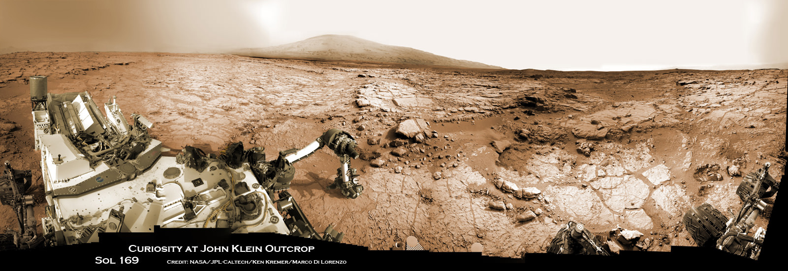
Curiosity accomplished Historic 1st drilling into Martian rock at John Klein outcrop on Feb 8, 2013 (Sol 182) and discovered a habitable zone, shown in this context mosaic view of the Yellowknife Bay basin taken on Jan. 26 (Sol 169). The robotic arm is pressing down on the surface at John Klein outcrop of veined hydrated minerals – dramatically back dropped with her ultimate destination; Mount Sharp. Credit: NASA/JPL-Caltech/Ken Kremer-kenkremer.com/Marco Di Lorenzo
This limited availability, timed experience is available on a first-come, first-served basis. Reservations must be made the day of your visite at the Destination: Mars reservation counter, says the KSC Visitor Complex (KSCVC).
You can get more information or book a visit to Kennedy Space Center Visitor Complex, by clicking on the website link:
Be sure to visit this spectacular holographic exhibit before it closes on New Year’s Day 2017 because it is only showing at KSCVC.
There are no plans to book it at other venues, Norris told me.
Apollo 11 moonwalker Buzz Aldrin describes newly opened ‘Destination Mars’ holographic experience during media preview at the Kennedy Space Center visitor complex in Florida on Sept. 18, 2016. Credit: Ken Kremer/kenkremer.com
As of today, Sol 1465, September 19, 2016, Curiosity has driven over 7.9 miles (12.7 kilometers) since its August 2012 landing inside Gale Crater, and taken over 354,000 amazing images.
Apollo 11 moonwalker Buzz Aldrin during media preview of newly opened ‘Destination Mars’ holographic experience at the Kennedy Space Center visitor complex in Florida on Sept. 18, 2016. Credit Julian Leek
Stay tuned here for Ken’s continuing Earth and planetary science and human spaceflight news.
This color view from NASA's Juno spacecraft is made from some of the first images taken by JunoCam after the spacecraft entered orbit around Jupiter on July 4, 2016. Credits: NASA/JPL-Caltech/SwRI/MSSS
This color view from NASA’s Juno spacecraft is made from some of the first images taken by JunoCam after the spacecraft entered orbit around Jupiter on July 4, 2016. Credits: NASA/JPL-Caltech/SwRI/MSSS
NASA’s newly arrived Jovian orbiter Juno has transmitted its first imagery since reaching orbit last week on July 4 after swooping over Jupiter’s cloud tops and powering back up its package of state-of-the-art science instruments for unprecedented research into determining the origin of our solar systems biggest planet.
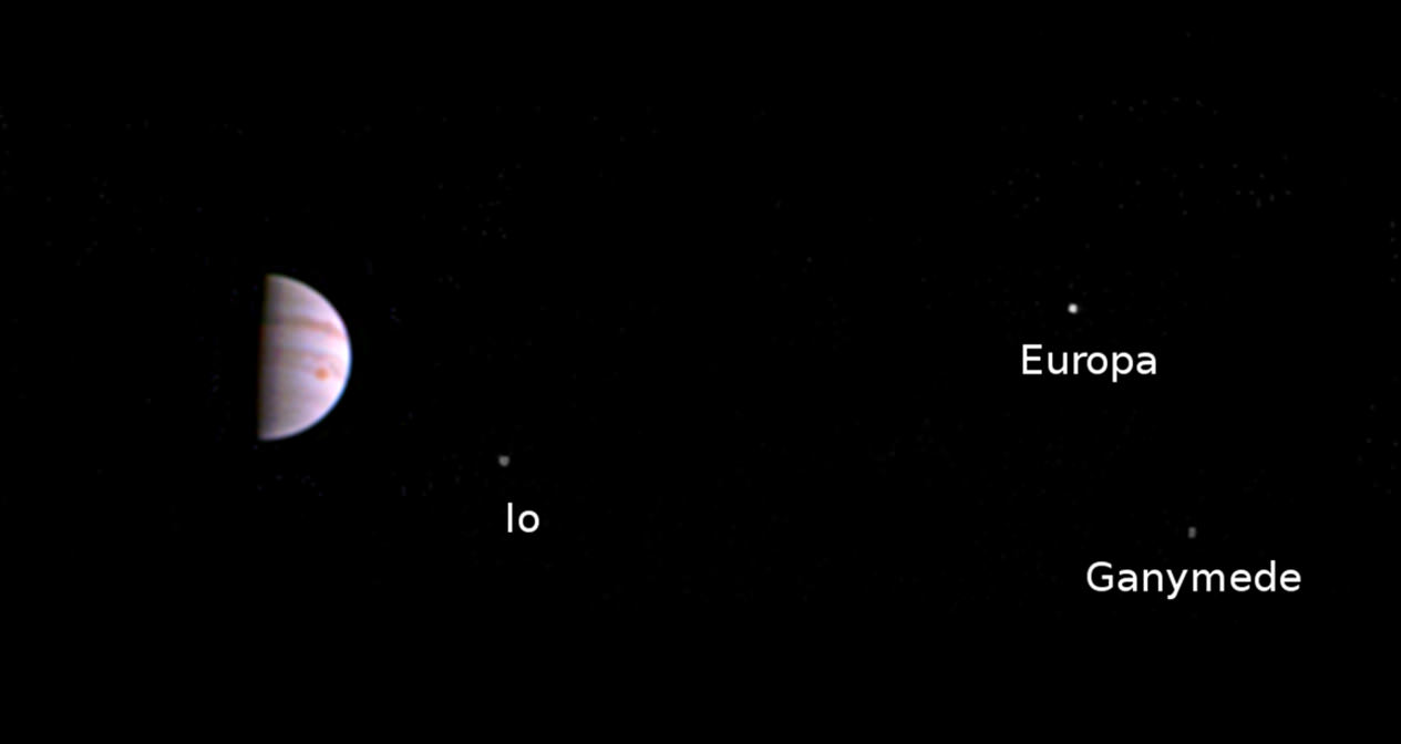
The ‘Galilean’ moons are annotated from left to right in the lead image.
Juno’s visible-light camera named JunoCam was turned on six days after Juno fired its main engine to slow down and be captured into orbit around Jupiter – the ‘King of the Planets’ following a nearly five year long interplanetary voyage from Earth.
The image was taken when Juno was 2.7 million miles (4.3 million kilometers) distant from Jupiter on July 10, at 10:30 a.m. PDT (1:30 p.m. EDT, 5:30 UTC), and traveling on the outbound leg of its initial 53.5-day capture orbit.
Juno came within only about 3000 miles of the cloud tops and passed through Jupiter’s extremely intense and hazardous radiation belts during orbital arrival over the north pole.
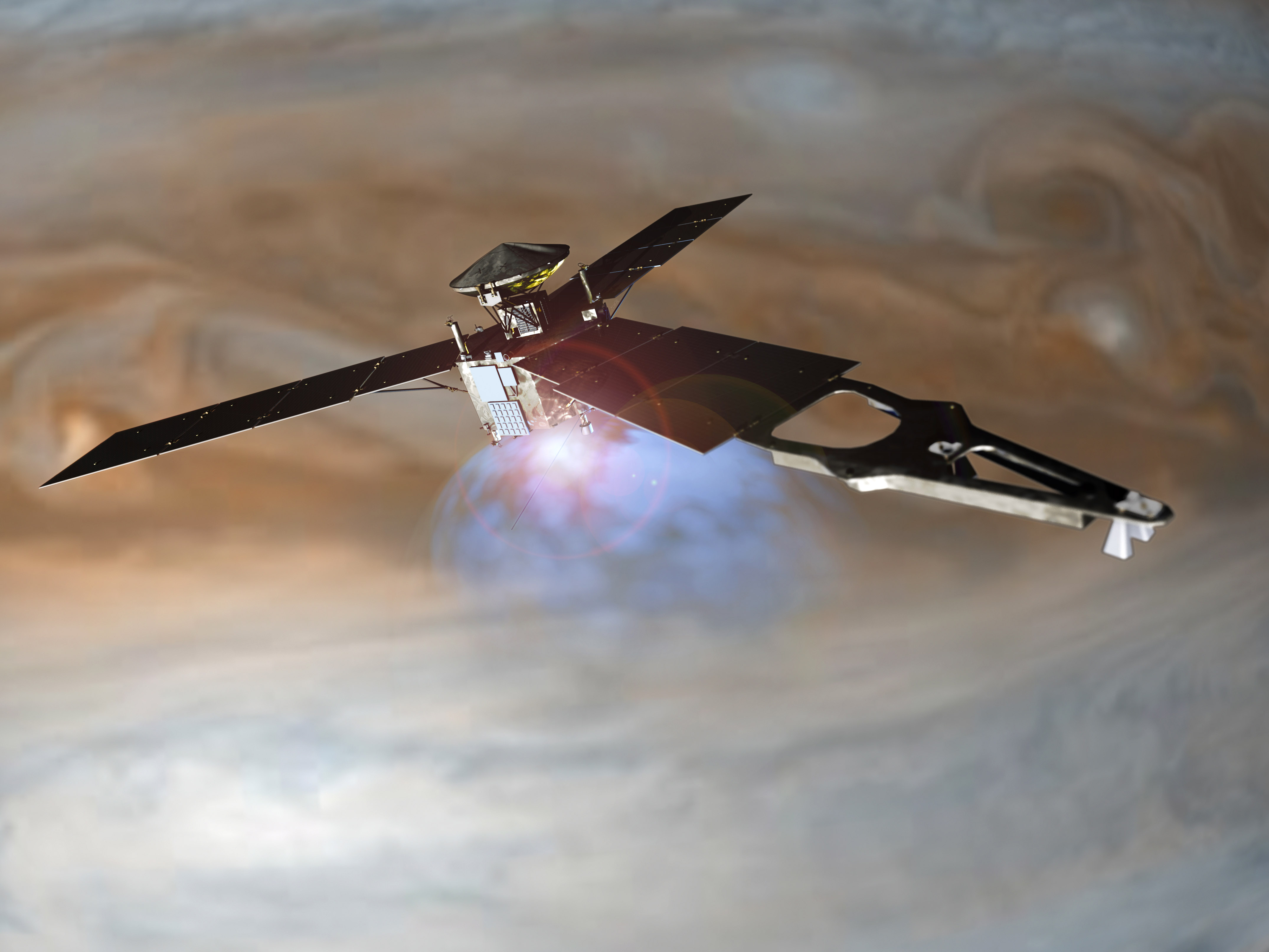
Illustration of NASA’s Juno spacecraft firing its main engine to slow down and go into orbit around Jupiter. Lockheed Martin built the Juno spacecraft for NASA’s Jet Propulsion Laboratory. Credit: NASA/Lockheed Martin
The newly released JunoCam image is visible proof that Juno survived the do-or-die orbital fireworks on America’s Independence Day that placed the baskeball-court sized probe into orbit around Jupiter – and is in excellent health to carry out its groundbreaking mission to elucidate Jupiter’s ‘Genesis.’
“This scene from JunoCam indicates it survived its first pass through Jupiter’s extreme radiation environment without any degradation and is ready to take on Jupiter,” said Scott Bolton, principal investigator from the Southwest Research Institute in San Antonio, in a statement.
“We can’t wait to see the first view of Jupiter’s poles.”
Within two days of the nerve wracking and fully automated 35-minute-long Jupiter Orbital Insertion (JOI) maneuver, the Juno engineering team begun powering up five of the probes science instruments on July 6.
Animation of Juno 14-day orbits starting in late 2016. Credits: NASA/JPL-Caltech
All nonessential instruments and systems had been powered down in the final days of Juno’s approach to Jupiter to ensure the maximum chances for success of the critical JOI engine firing.
“We had to turn all our beautiful instruments off to help ensure a successful Jupiter orbit insertion on July 4,” said Bolton.
“But next time around we will have our eyes and ears open. You can expect us to release some information about our findings around September 1.”
Juno resumed high data rate communications with Earth on July 5, the day after achieving orbit.
We can expect to see more JunoCam images taken during this first orbital path around the massive planet.
But the first high resolution images are still weeks away and will not be available until late August on the inbound leg when the spacecraft returns and swoops barely above the clouds.
“JunoCam will continue to take images as we go around in this first orbit,” said Candy Hansen, Juno co-investigator from the Planetary Science Institute, Tucson, Arizona, in a statement.
“The first high-resolution images of the planet will be taken on August 27 when Juno makes its next close pass to Jupiter.”
All of JunoCams images will be released to the public.
During a 20 month long science mission – entailing 37 orbits lasting 14 days each – the probe will plunge to within about 2,600 miles (4,100 kilometers) of the turbulent cloud tops.
It will collect unparalleled new data that will unveil the hidden inner secrets of Jupiter’s origin and evolution as it peers “beneath the obscuring cloud cover of Jupiter and study its auroras to learn more about the planet’s origins, structure, atmosphere and magnetosphere.”
The solar powered Juno spacecraft approached Jupiter over its north pole, affording an unprecedented perspective on the Jovian system – “which looks like a mini solar system” – as it flew through the giant planets intense radiation belts in ‘autopilot’ mode.
Juno is the first solar powered probe to explore Jupiter or any outer planet.
In the final weeks of the approach JunoCam captured dramatic views of Jupiter and all four of the Galilean Moons moons — Io, Europa, Ganymede and Callisto.
At the post JOI briefing on July 5, these were combined into a spectacular JunoCam time-lapse movie released by Bolton and NASA.
Watch and be mesmerized -“for humanity, our first real glimpse of celestial harmonic motion” says Bolton.
Video caption: NASA’s Juno spacecraft captured a unique time-lapse movie of the Galilean satellites in motion about Jupiter. The movie begins on June 12th with Juno 10 million miles from Jupiter, and ends on June 29th, 3 million miles distant. The innermost moon is volcanic Io; next in line is the ice-crusted ocean world Europa, followed by massive Ganymede, and finally, heavily cratered Callisto. Galileo observed these moons to change position with respect to Jupiter over the course of a few nights. From this observation he realized that the moons were orbiting mighty Jupiter, a truth that forever changed humanity’s understanding of our place in the cosmos. Earth was not the center of the Universe. For the first time in history, we look upon these moons as they orbit Jupiter and share in Galileo’s revelation. This is the motion of nature’s harmony. Credits: NASA/JPL-Caltech/MSSS
The $1.1 Billion Juno was launched on Aug. 5, 2011 from Cape Canaveral, Florida atop the most powerful version of the Atlas V rocket augmented by 5 solid rocket boosters and built by United Launch Alliance (ULA). That same Atlas V 551 version just launched MUOS-5 for the US Navy on June 24.
The Juno spacecraft was built by prime contractor Lockheed Martin in Denver.
The mission will end in February 2018 with an intentional death dive into the atmosphere to prevent any possibility of a collision with Europa, one of Jupiter’s moons that is a potential abode for life.
The last NASA spacecraft to orbit Jupiter was Galileo in 1995. It explored the Jovian system until 2003.
From Earth’s perspective, Jupiter was in conjunction with Earth’s Moon shortly after JOI during the first week in July.
Personally its thrilling to realize that an emissary from Earth is once again orbiting Jupiter after a 13 year long hiatus as seen in the authors image below – coincidentally taken the same day as JunoCam’s first image from orbit.
Juno, Jupiter and the Moon as seen from I-95 over Dunn, NC on July 10, 2016. Credit: Ken Kremer/kenkremer.com
Stay tuned here for Ken’s continuing Earth and Planetary science and human spaceflight news.
Learn more about Juno at Jupiter, SpaceX CRS-9 rocket launch, ISS, ULA Atlas and Delta rockets, Orbital ATK Cygnus, Boeing, Space Taxis, Mars rovers, Orion, SLS, Antares, NASA missions and more at Ken’s upcoming outreach events:
July 15-18: “SpaceX launches to ISS on CRS-9, Juno at Jupiter, ULA Delta 4 Heavy spy satellite, SLS, Orion, Commercial crew, Curiosity explores Mars, Pluto and more,” Kennedy Space Center Quality Inn, Titusville, FL, evenings
NASA’s Juno probe captured the image data for this composite picture during its Earth flyby on Oct. 9 over Argentina, South America and the southern Atlantic Ocean. Raw imagery was reconstructed and aligned by Ken Kremer and Marco Di Lorenzo, and false-color blue has been added to the view taken by a near-infrared filter that is typically used to detect methane. Credit: NASA/JPL/SwRI/MSSS/Ken Kremer/Marco Di Lorenzo
This annotated color view of Jupiter and its four largest moons -- Io, Europa, Ganymede and Callisto -- was taken by the JunoCam camera on NASA's Juno spacecraft on June 21, 2016, at a distance of 6.8 million miles (10.9 million kilometers) from Jupiter. Image credit: NASA/JPL-Caltech/MSSS
This annotated color view of Jupiter and its four largest moons — Io, Europa, Ganymede and Callisto — was taken by the JunoCam camera on NASA’s Juno spacecraft on June 21, 2016, at a distance of 6.8 million miles (10.9 million kilometers) from Jupiter. Image credit: NASA/JPL-Caltech/MSSS
Now just 7 days out from a critical orbital insertion burn, NASA’s Jupiter-boundJuno orbiter is closing in fast on the massive gas giant. And as its coming into focus the spacecraft has begun snapping a series of beautiful images of the biggest planet and its biggest moons.
In a newly released color image snapped by the probes educational public outreach camera named Junocam, banded Jupiter dominates a spectacular scene that includes the giant planet’s four largest moons — Io, Europa, Ganymede and Callisto.
Junocam’s image of the approaching Jovian system was taken on June 21, 2016, at a distance of 6.8 million miles (10.9 million kilometers) and hints at the multitude of photos and science riches to come from Juno.
“Juno on Jupiter’s Doorstep,” says a NASA description. “And the alternating light and dark bands of the planet’s clouds are just beginning to come into view,” revealing its “distinctive swirling bands of orange, brown and white.”
This color view of Jupiter and its four largest moons — Io, Europa, Ganymede and Callisto — was taken by the JunoCam camera on NASA’s Juno spacecraft on June 21, 2016, at a distance of 6.8 million miles (10.9 million kilometers) from Jupiter. Image credit: NASA/JPL-Caltech/MSSS
Rather appropriately for an American space endeavor, the fate of the entire mission hinges on do or die ‘Independence Day’ fireworks.
On the evening of July 4, Juno must fire its main engine for 35 minutes.
The Joy of JOI – or Jupiter Orbit Insertion – will place NASA’s robotic explorer into a polar orbit around the gas giant.
The approach over the north pole is unlike earlier probes that approached from much lower latitudes nearer the equatorial zone, and thus provide a perspective unlike any other.
After a five-year and 2.8 Billion kilometer (1.7 Billion mile) outbound trek to the Jovian system and the largest planet in our solar system and an intervening Earth flyby speed boost, the moment of truth for Juno is now inexorably at hand.
This colorized composite shows more than half of Earth’s disk over the coast of Argentina and the South Atlantic Ocean as the Juno probe slingshotted by on Oct. 9, 2013 for a gravity assisted acceleration to Jupiter. The mosaic was assembled from raw images taken by the Junocam imager. Credit: NASA/JPL/SwRI/MSSS/Ken Kremer/Marco Di Lorenzo
And preparations are in full swing by the science and engineering team to ensure a spectacular Fourth of July fireworks display.
The team has been in contact with Juno 24/7 since June 11 and already uplinked the rocket firing parameters.
Signals traveling at the speed of light take 10 minutes to reach Earth.
The protective cover that shields Juno’s main engine from micrometeorites and interstellar dust was opened on June 20.
“And the software program that will command the spacecraft through the all-important rocket burn was uplinked,” says NASA.
The pressurization of the propulsion system is set for June 28.
“We have over five years of spaceflight experience and only 10 days to Jupiter orbit insertion,” said Rick Nybakken, Juno project manager from NASA’s Jet Propulsion Laboratory in Pasadena, California, said in a statement.
“It is a great feeling to put all the interplanetary space in the rearview mirror and have the biggest planet in the solar system in our windshield.”
On the night of orbital insertion, Juno will fly within 2,900 miles (4,667 kilometers) of the Jovian cloud tops.
All instruments except those critical for the JOI insertion burn on July 4, will be tuned off on June 29. That includes shutting down Junocam.
“If it doesn’t help us get into orbit, it is shut down,” said Scott Bolton, Juno’s principal investigator from the Southwest Research Institute in San Antonio.
“That is how critical this rocket burn is. And while we will not be getting images as we make our final approach to the planet, we have some interesting pictures of what Jupiter and its moons look like from five-plus million miles away.”
During a 20 month long science mission – entailing 37 orbits lasting 11 days each – the probe will plunge to within about 3000 miles of the turbulent cloud tops and collect unprecedented new data that will unveil the hidden inner secrets of Jupiter’s origin and evolution.
“Jupiter is the Rosetta Stone of our solar system,” says Bolton. “It is by far the oldest planet, contains more material than all the other planets, asteroids and comets combined and carries deep inside it the story of not only the solar system but of us. Juno is going there as our emissary — to interpret what Jupiter has to say.”
During the orbits, Juno will probe beneath the obscuring cloud cover of Jupiter and study its auroras to learn more about the planet’s origins, structure, atmosphere and magnetosphere.
Junocam has already taken some striking images during the Earth flyby gravity assist speed boost on Oct. 9, 2013.
For example the dazzling portrait of our Home Planet high over the South American coastline and the Atlantic Ocean.
For a hint of what’s to come, see our colorized Junocam mosaic of land, sea and swirling clouds, created by Ken Kremer and Marco Di Lorenzo.
NASA’s Juno probe captured the image data for this composite picture during its Earth flyby on Oct. 9 over Argentina, South America and the southern Atlantic Ocean. Raw imagery was reconstructed and aligned by Ken Kremer and Marco Di Lorenzo, and false-color blue has been added to the view taken by a near-infrared filter that is typically used to detect methane. Credit: NASA/JPL/SwRI/MSSS/Ken Kremer/Marco Di Lorenzo
As Juno sped over Argentina, South America and the South Atlantic Ocean it came within 347 miles (560 kilometers) of Earth’s surface.
During the flyby, the science team observed Earth using most of Juno’s nine science instruments since the slingshot also serves as an important dress rehearsal and key test of the spacecraft’s instruments, systems and flight operations teams.
Juno soars skyward to Jupiter on Aug. 5, 2011 from launch pad 41 at Cape Canaveral Air Force Station at 12:25 p.m. EDT. View from the VAB roof. Credit: Ken Kremer/kenkremer.com
This prototype 13-kilowatt Hall thruster was tested at NASA's Glenn Research Center in Cleveland and will be used by industry to develop high-power solar electric propulsion into a flight-qualified system. Credits: NASA
This prototype 13-kilowatt Hall thruster was tested at NASA’s Glenn Research Center in Cleveland and will be used by industry to develop high-power solar electric propulsion into a flight-qualified system. Credits: NASA
Under the 3 year, $67 million contract award, Aerojet Rocketdyne will develop the engineering development unit for an Advanced Electric Propulsion System (AEPS) with the potential for follow on flight units.
NASA hopes that the work will result in a 10 fold increase in “spaceflight transportation fuel efficiency compared to current chemical propulsion technology and more than double thrust capability compared to current electric propulsion systems.”
The SEP effort is based in part on NASA’s exploratory work on Hall ion thrusters which trap electrons in a magnetic field and uses them to ionize and accelerate the onboard xenon gas propellant to produce thrust much more efficiently than chemical thrusters.
The solar electric propulsion (SEP) system technology will afford benefits both to America’s commercial space and scientific space exploration capabilities.
For NASA, the SEP technology can be applied for expeditions to deep space such as NASA’s planned Asteroid Robotic Redirect Mission (ARRM) to snatch a boulder from the surface of an asteroid and return it to cislunar space during the 2020s, as well as to carry out the agency’s ambitious plans to send humans on a ‘Journey to Mars’ during the 2030s.
“High power SEP is a perfect example of NASA developing cross cutting technologies to enable both human and robotic deep space missions. Basically it enables high efficiency and better gas mileage,” said Steve Jurczyk, associate administrator of NASA’s Space Technology Mission Directorate (STMD) in Washington, at a media briefing.
“The advantage here is the higher power and the higher thrust.”
“Our plan right now is to flight test the higher power solar electric propulsion that Aerojet Rocketdyne will develop for us on the Asteroid Redirect Robotic Mission (ARRM), which is going to go out to an asteroid with a robotic system, grab a boulder off of an asteroid, and bring it back to a lunar orbit.”
ARRM would launch around 2020 or 2021. Astronauts would blast off several years later in NASA’s Orion crew capsule in 2025 after the robotic probes travels back to lunar orbit.
For industry, electric propulsion is used increasingly to maneuver thrusters in Earth orbiting commercial satellites for station keeping in place of fuel.
“Through this contract, NASA will be developing advanced electric propulsion elements for initial spaceflight applications, which will pave the way for an advanced solar electric propulsion demonstration mission by the end of the decade,” says Jurczyk.
“Development of this technology will advance our future in-space transportation capability for a variety of NASA deep space human and robotic exploration missions, as well as private commercial space missions.”
This 13-kilowatt Hall thruster is being evaluated at NASA’s Glenn Research Center in Cleveland for advanced solar electric propulsion. Hall thrusters trap electrons in a magnetic field and use them to ionize the onboard propellant. Credits: NASA
“This is also a critical capability for enabling human missions to Mars, with respect to delivering cargo to the surface to Mars that will allow people to live and work there on the surface. Also for combined chemical and SEP systems on a spacecraft to propel humans to Mars,” elaborated Jurczyk at the briefing.
“Another application is round trip robotic science missions to Mars to bring back samples – such as a Mars Sample Return (MSR) mission.”
The starting point is NASA’s development and technology readiness testing of a prototype 13-kilowatt Hall thruster and power processing unit at NASA’s Glenn Research Center in Cleveland.
Under the contract award Aerojet Rocketdyne aims to carry out the industrial development of “high-power solar electric propulsion into a flight-qualified system.”
They will develop, build, test and deliver “an integrated electric propulsion system consisting of a thruster, power processing unit (PPU), low-pressure xenon flow controller, and electrical harness,” as an engineering development unit.
This engineering development unit serves as the basis for producing commercial flight units.
If successful, NASA has an option to purchase up to four integrated flight units for actual space missions. Engineers from NASA Glenn and the Jet Propulsion Laboratory (JPL) will provide technical support.
“We could string together four of these engine units to get approximately 50 kilowatts of electrical propulsion capability and with that we can do significant orbital transfer operations. That then becomes the next step in deep space exploration operations that we are trying to do,” said Bryan Smith, director of the Space Flight Systems Directorate at NASA’s Glenn Research Center in Cleveland, at the media briefing.
“We hope to buy four of these units for the ARRM mission.”
What were some of NASA’s research and development (R&D) activities and further plans for Aerojet Rocketdyne?
“NASA is driving out the technology itself for feasibility. So we produced a developmental device to operate at these levels,” Smith told Universe Today during the briefing.
“Other key characteristics we were looking for is the ability to do magnetic shielding. The purpose was to allow for a long life thruster operation. We investigated attributes like thermal problems and balancing the erosion mechanisms in developmental units. So we were looking for things to get longer life and feasibility in developmental units.”
“Once we were comfortable with the feasibility in developmental units, we are now transferring the information, technology and knowhow into what is a production article, in this contract.”
Robotic sampling arm and capture mechanism to collect a multi-ton boulder from an asteroid are under development at NASA Goddard and other agency centers for NASA’s unmanned Asteroid Redirect Vehicle and eventual docking in lunar orbit with Orion crew vehicle by the mid 2020s. Credit: Ken Kremer/kenkremer.com
Solar electric ion propulsion is already being used in NASA’s hugely successful Dawn asteroid orbiter mission.
Dawn was launched in 2007. It orbited and surveyed Vesta in 2011 and 2012 and then traveled outward to Ceres.
Dawn arrived at dwarf planet Ceres in March 2015 and is currently conducting breakthrough science at its lowest planned science mapping orbit.
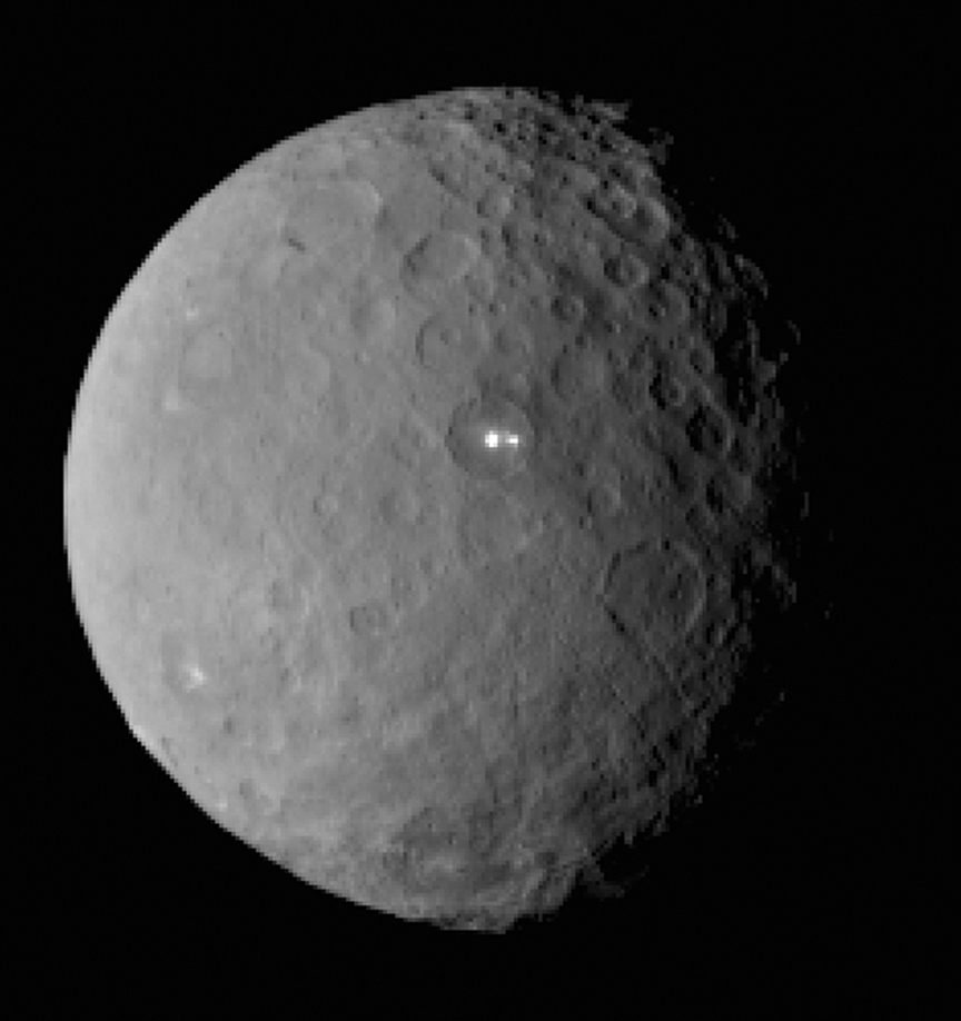
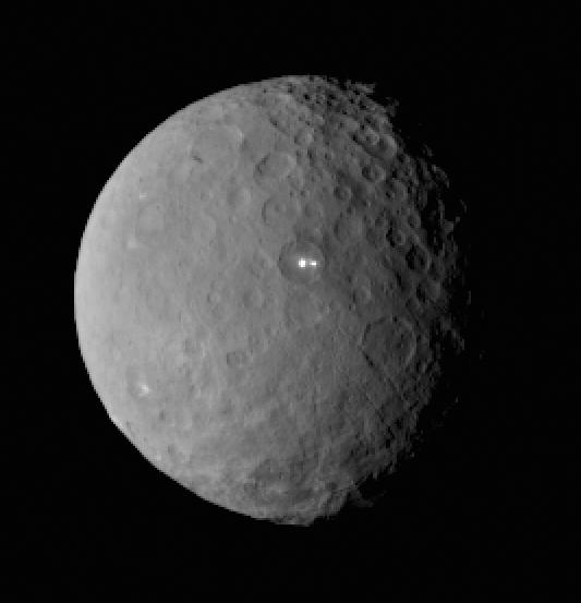
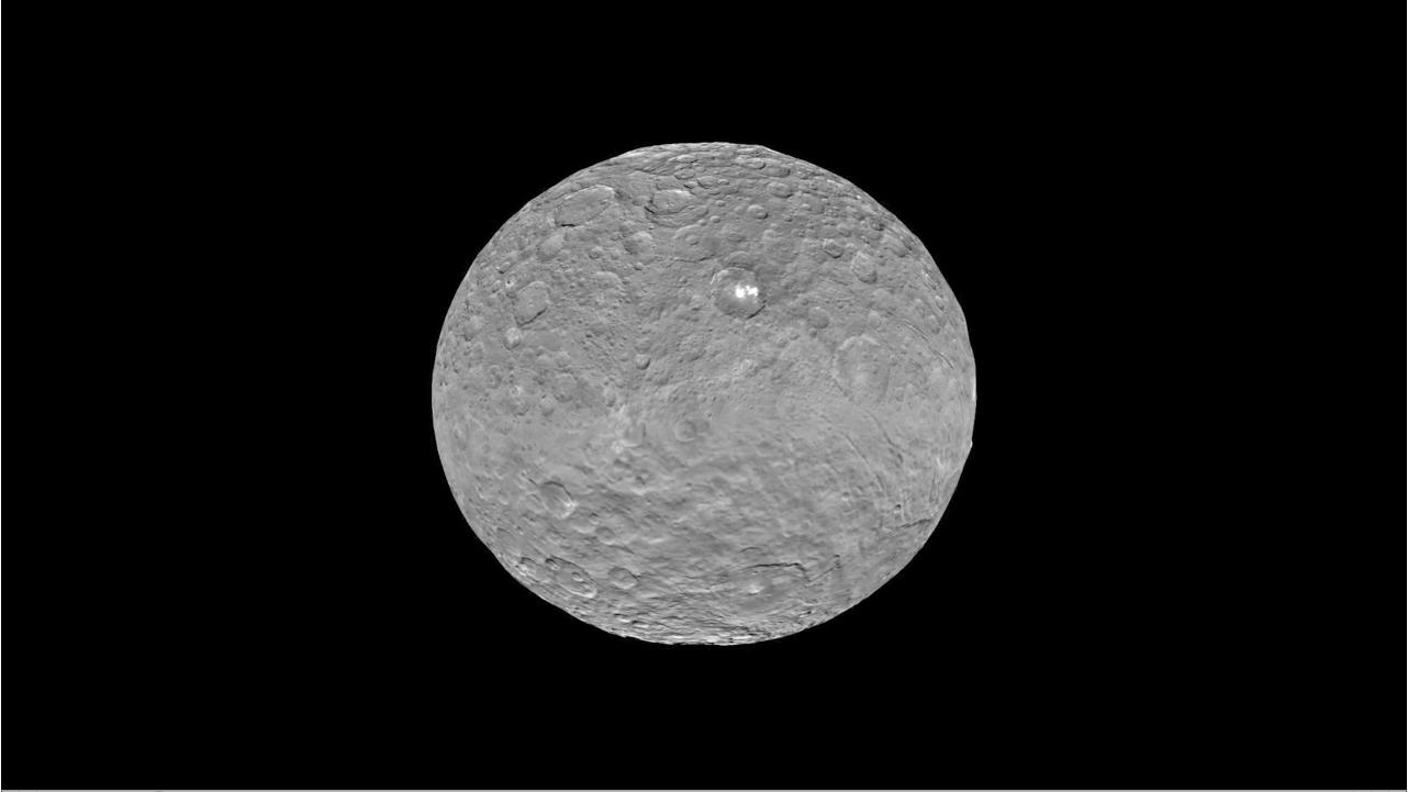
This image was taken by NASA’s Dawn spacecraft of dwarf planet Ceres on Feb. 19 from a distance of nearly 29,000 miles (46,000 km). It shows that the brightest spot on Ceres has a dimmer companion, which apparently lies in the same basin. Credit: NASA/JPL-Caltech/UCLA/MPS/DLR/IDA
A key part of the Journey to Mars, NASA will be sending cargo missions to the Red Planet to pave the way for human expeditions with the Orion crew module and Space Launch System.
Aerojet Rocketdyne states that “Solar Electric Propulsion (SEP) systems have demonstrated the ability to reduce the mission cost for NASA Human Exploration cargo missions by more than 50 percent through the use of existing flight-proven SEP systems.”
“Using a SEP tug for cargo delivery, combined with NASA’s Space Launch System and the Orion crew module, provides an affordable path for deep space exploration,” said Aerojet Rocketdyne Vice President, Space and Launch Systems, Julie Van Kleeck.
Aerojet Rocketdyne artists concept for solar electric propulsion system for deep space missions. Credit: Aerojet Rocketdyne
Another near term application of high power solar electric propulsion could be for NASA’s proposed Mars 2022 telecom orbiter, said Smith at the media briefing.
Other NASA technology work in progress includes development of more efficient, advanced solar array systems to generate the additional power required for the larger electric thrusters.
Orbital ATK was part of the development effort and already used some of its technology development in the ultraflex solar arrays on the recent Cygnus cargo ships delivering supplies to the ISS.
Stay tuned here for Ken’s continuing Earth and planetary science and human spaceflight news.
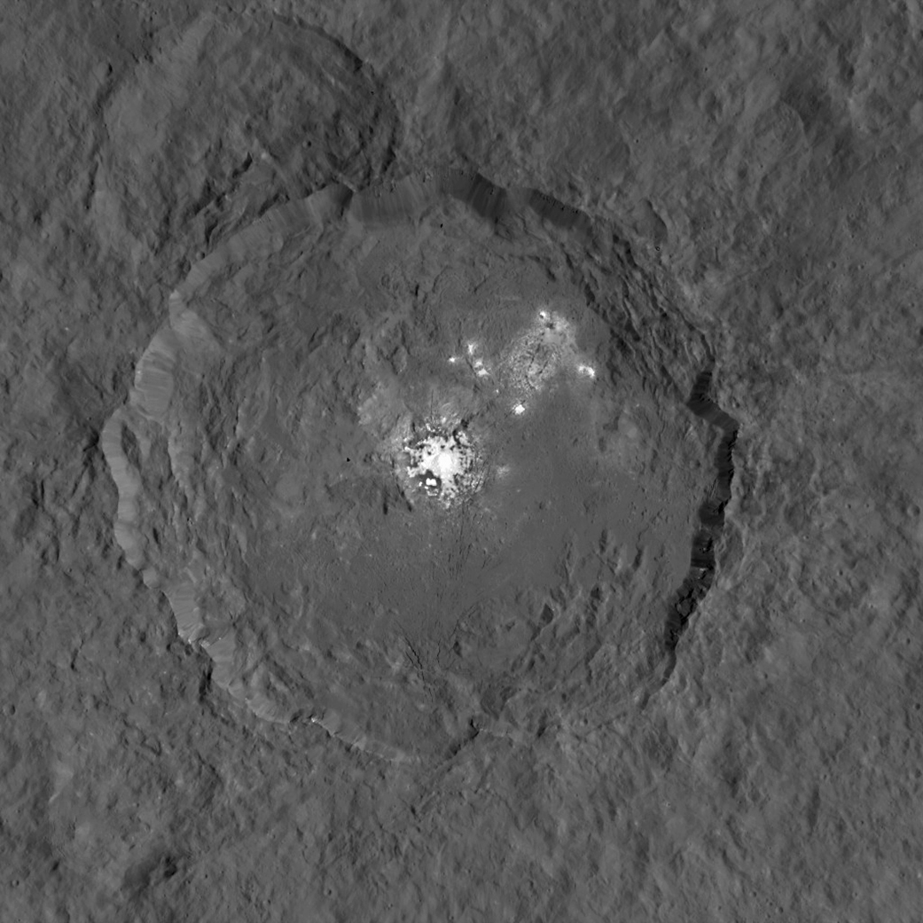
This image, made using images taken by NASA's Dawn spacecraft during the mission's High Altitude Mapping Orbit (HAMO) phase, shows Occator crater on Ceres, home to a collection of intriguing bright spots. Credits: NASA/JPL-Caltech/UCLA/MPS/DLR/IDA
This image, made using images taken by NASA’s Dawn spacecraft during the mission’s High Altitude Mapping Orbit (HAMO) phase, shows Occator crater on Ceres, home to a collection of intriguing bright spots. Credits: NASA/JPL-Caltech/UCLA/MPS/DLR/IDA
Story/imagery updated[/caption]
Since scientists believe that Ceres occupies a “unique niche” in the solar system and apparently harbors subsurface ice or liquid oceans, could the bright spots arise from subsurface “water leakage?” To find out Universe Today asked Dawn’s Principal Investigator and Chief Engineer.
“The big picture that is emerging is that Ceres fills a unique niche,” Prof. Chris Russell, Dawn principal investigator told Universe Today exclusively.
“Ceres fills a unique niche between the cold icy bodies of the outer solar system, with their rock hard icy surfaces, and the water planets Mars and Earth that can support ice and water on their surfaces,” said Russell, of the University of California, Los Angeles.
And with Dawn recently arrived at its second lowest science mapping orbit of the planned mission around icy dwarf planet Ceres in mid-August, the NASA spacecraft is capturing the most stunningly detailed images yet of those ever intriguing bright spots located inside Occator crater.
The imagery and other science data may point to evaporation of salty water as the source of the bright spots.
“Occasional water leakage on to the surface could leave salt there as the water would sublime,” Russell told me.
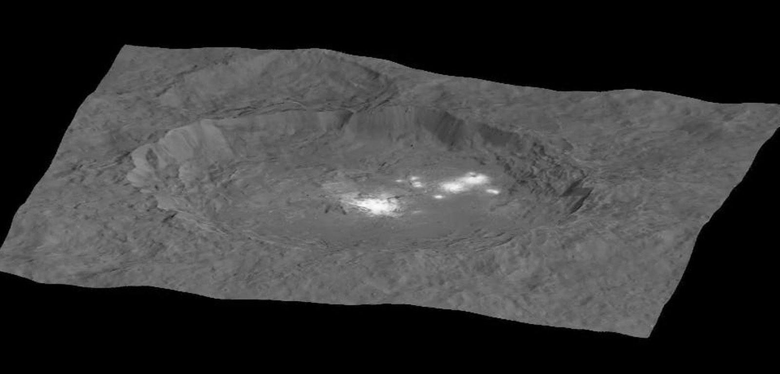
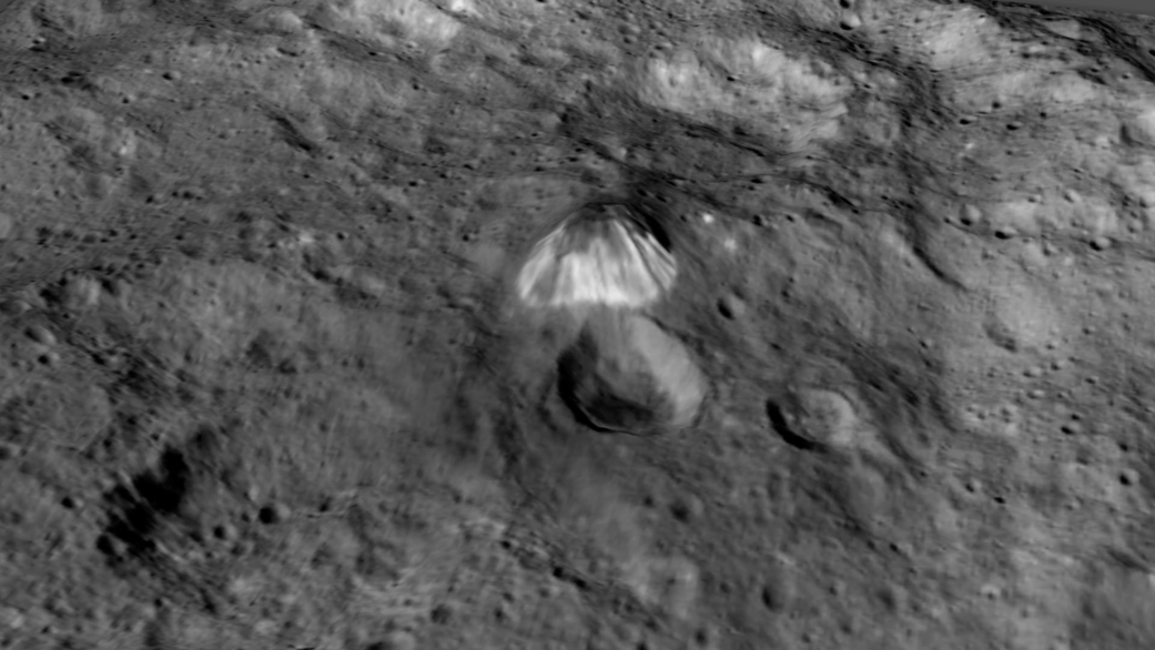
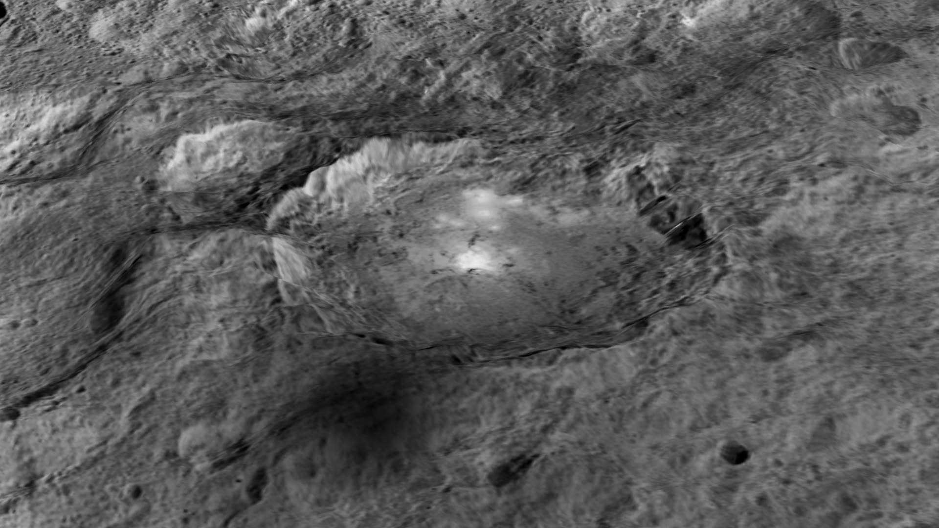
Circling the Lights of Occator crater on Ceres. This image, made using images taken by NASA’s Dawn spacecraft during the mission’s High Altitude Mapping Orbit (HAMO) phase and draped over a shape model, shows Occator crater on Ceres, home to a collection of intriguing bright spots. The image has been stretched by 1.5 times in the vertical direction to better illustrate the crater’s topography. Credits: NASA/JPL-Caltech/UCLA/MPS/DLR/IDA
Dawn is Earth’s first probe to explore any dwarf planet and the first to explore Ceres up close. It was built by Orbital ATK.
To shed more light on what still remains rather mysterious even today, NASA has just released the best yet imagery, which was taken at Dawn’s High Altitude Mapping Orbit (HAMO) phase and they raise as many questions as they answer.
Occator has captured popular fascination world-wide because the 60 miles (90 kilometers) diameter crater is rife with the alien bodies brightest spots and whose nature remains elusive to this day, over half a year after Dawn arrived in orbit this past spring on March 6, 2015.
The new imagery from Dawn’s current HAMO mapping orbit was taken at an altitude of just 915 miles (1,470 kilometers). They provide about three times better resolution than the images captured from its previous orbit in June, and nearly 10 times better than in the spacecraft’s initial orbit at Ceres in April and May, says the team.
So with the new HAMO orbit images in hand, I asked the team what’s the latest thinking on the bright spots nature?
Initially a lot of speculation focused on water ice. But the scientists opinions have changed substantially as the data pours in from the lower orbits and forced new thinking on alternative hypotheses – to the absolute delight of the entire team!
“When the spots appeared at first to have an albedo approaching 100%, we were forced to think about the possibility of [water] ice being on the surface,” Russell explained.
“However the survey data revealed that the bright spots were only reflecting about 50% of the incoming light.”
“We did not like the ice hypothesis because ice sublimes under the conditions on Ceres surface. So we were quite relieved by the lower albedo.”
“So what could be 50% reflective? If we look at Earth we find that when water evaporates on the desert it leaves salt which is reflective. We know from its density that water or ice is inside Ceres.”
“So the occasional water leakage on to the surface could leave salt there as the water would sublime even faster than ice.”
At this time no one knows how deep the potential ice deposit or water reservoir sources of the “water leakage” reside beneath the surface, or whether the bright salt spots arose from past or current activity and perhaps get replenished or enlarged over time. To date there is no evidence showing plumes currently erupting from the Cerean surface.
Video Caption: Circling Occator Crater on Ceres. This animation, made using data from NASA’s Dawn spacecraft, shows the topography of Occator crater on Ceres. Credits: Credit: NASA/JPL-Caltech/UCLA/MPS/DLR/IDA/PSI
Dawn is an international science mission and equipped with a trio of state of the art science instruments from Germany, Italy and the US. They will elucidate the overall elemental and chemical composition and nature of Ceres, its bright spots and other wondrous geological features like the pyramidal mountain object.
I asked the PI and Chief Engineer to explain specifically how and which of the instruments is the team using right now at HAMO to determine the bright spots composition?
“The instruments that will reveal the composition of the spots are the framing camera [from Germany], the infrared spectrometer, and the visible spectrometer [both from the VIR instrument from Italy], replied Dr. Marc Rayman, Dawn’s chief engineer and mission director based at NASA’s Jet Propulsion Laboratory, Pasadena, California.
“Dawn arrived in this third mapping orbit [HAMO] on Aug. 13. It began this third mapping phase on schedule on Aug. 17.”
But much work remains to gather and interpret the data and discern the identity of which salts are actually present on Ceres.
“While salts of various sorts have the right reflectance, they are hard to distinguish from one another in the visible,” Russell elaborated to Universe Today.
“That is one reason VIR is working extra hard on the IR spectrum. Scientists are beginning to speculate on the salts. And to think about what salts could be formed in the interior.”
“That is at an early stage right now,” Russell stated.
“I know of nothing exactly like these spots anywhere. We are excited about these scientific surprises!”
Occator crater lies in Ceres northern hemisphere.
“There are other lines of investigation besides direct compositional measurement that will provide insight into the spots, including the geological context,” Rayman told Universe Today.
Each of Dawn’s two framing cameras is also outfitted with a wheel of 7 color filters, explained Joe Makowski, Dawn program manager from Orbital ATK, in an interview.
Different spectral data is gathered using the different filters which can be varied during each orbit.
“So far Dawn has completed 2 mapping orbit cycles of the 6 cycles planned at HAMO.”
Each HAMO mapping orbit cycle lasts 11 days and consists of 14 orbits lasting 19 hours each. Ceres is entirely mapped during each of the 6 cycles. The third mapping cycle just started on Wednesday, Sept. 9.
The instruments will be aimed at slightly different angle in each mapping cycle allowing the team to generate stereo views and construct 3-D maps.
“The emphasis during HAMO is to get good stereo data on the elevations of the surface topography and to get good high resolution clear and color data with the framing camera,” Russell explained.
“We are hoping to get lots of VIR IR data to help understand the composition of the surface better.”
“Dawn will use the color filters in its framing camera to record the sights in visible and infrared wavelengths,” notes Rayman.
“Dawn remains at HAMO until October 23. Then it begins thrusting with the ion propulsion thrusters to reach its lowest mapping orbit named LAMO [Low Altitude Mapping Orbit],” Makowski told me.
“Dawn will arrive at LAMO on December 15, 2015.”
That’s a Christmas present we can all look forward to with glee!
This image was taken by NASA’s Dawn spacecraft of dwarf planet Ceres on Feb. 19 from a distance of nearly 29,000 miles (46,000 kilometers). It shows that the brightest spot on Ceres has a dimmer companion, which apparently lies in the same basin. Image Credit: NASA/JPL-Caltech/UCLA/MPS/DLR/IDA
What is the teams reaction, interplay and interpretation regarding the mountains of new data being received from Dawn? How do the geologic processes compare to Earth?
“Dawn has transformed what was so recently a few bright dots into a complex and beautiful, gleaming landscape,” says Rayman. “Soon, the scientific analysis will reveal the geological and chemical nature of this mysterious and mesmerizing extraterrestrial scenery.”
“We do believe we see geologic processes analogous to those on Earth – but with important Cerean twists,” Russell told me.
“However we are at a point in the mission where conservative scientists are interpreting what we see in terms of familiar processes. And the free thinkers are imagining wild scenarios for what they see.”
“The next few weeks (months?) will be a time where the team argues amongst themselves and finds the proper compromise between tradition and innovation,” Russell concluded elegantly.
Among the highest features seen on Ceres so far is a mountain about 4 miles (6 kilometers) high, which is roughly the elevation of Mount McKinley in Alaska’s Denali National Park. Vertical relief has been exaggerated by a factor of five to help understand the topography. Credits: NASA/JPL-Caltech/UCLA/MPS/DLR/IDA/LPI
A batch of new results from Dawn at Ceres are expected to be released during science presentations at the European Planetary Science Congress 2015 being held in Nantes, France from 27 September to 2 October 2015.
The Dawn mission is expected to last until at least March 2016, and possibly longer, depending upon fuel reserves.
“It will end some time between March and December,” Rayman told me.
The science objectives in the LAMO orbit could be achieved as soon as March. But the team wants to extend operations as long as possible, perhaps to June or beyond, if the spacecraft remains healthy and has sufficient hydrazine maneuvering fuel and NASA funding to operate.
“We expect Dawn to complete the mission objectives at Ceres by March 2016. June is a the programmatic milestone for end of the nominal mission, effectively a time margin,” Makowski told Universe Today.
“The team is working to a well-defined exploration plan for Ceres, which we expect to accomplish by March, if all goes well.”
“At launch Dawn started with 45 kg of hydrazine. It has about 21 kg of usable hydrazine onboard as of today.”
“We expect to use about 15 kg during the nominal remaining mission,” Makowski stated.
Therefore Dawn may have roughly 5 kg or so of hydrazine fuel for any extended mission, if all goes well, that may eventually be approved by NASA. Of course NASA’s budget depends also on what is approved by the US Congress.
The intriguing brightest spots on Ceres lie in a crater named Occator, which is about 60 miles (90 kilometers) across and 2 miles (4 kilometers) deep. Vertical relief has been exaggerated by a factor of five. Exaggerating the relief helps scientists understand and visualize the topography much more easily, and highlights features that are sometimes subtle. Credits: NASA/JPL-Caltech/UCLA/MPS/DLR/IDA/LPI
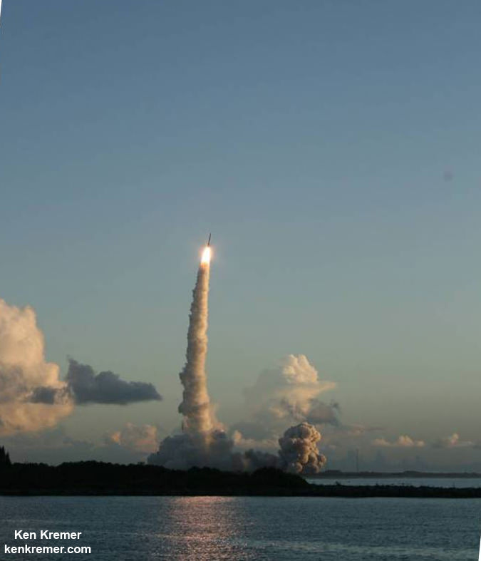
Dawn was launched on September 27, 2007 by a United Launch Alliance (ULA) Delta II Heavy rocket from Space Launch Complex-17B (SLC-17B) at Cape Canaveral Air Force Station, Florida.
Stay tuned here for Ken’s continuing Earth and planetary science and human spaceflight news.
Dawn launch on September 27, 2007 by a United Launch Alliance Delta II Heavy rocket from Cape Canaveral Air Force Station, Florida. Credit: Ken Kremer/kenkremer.com
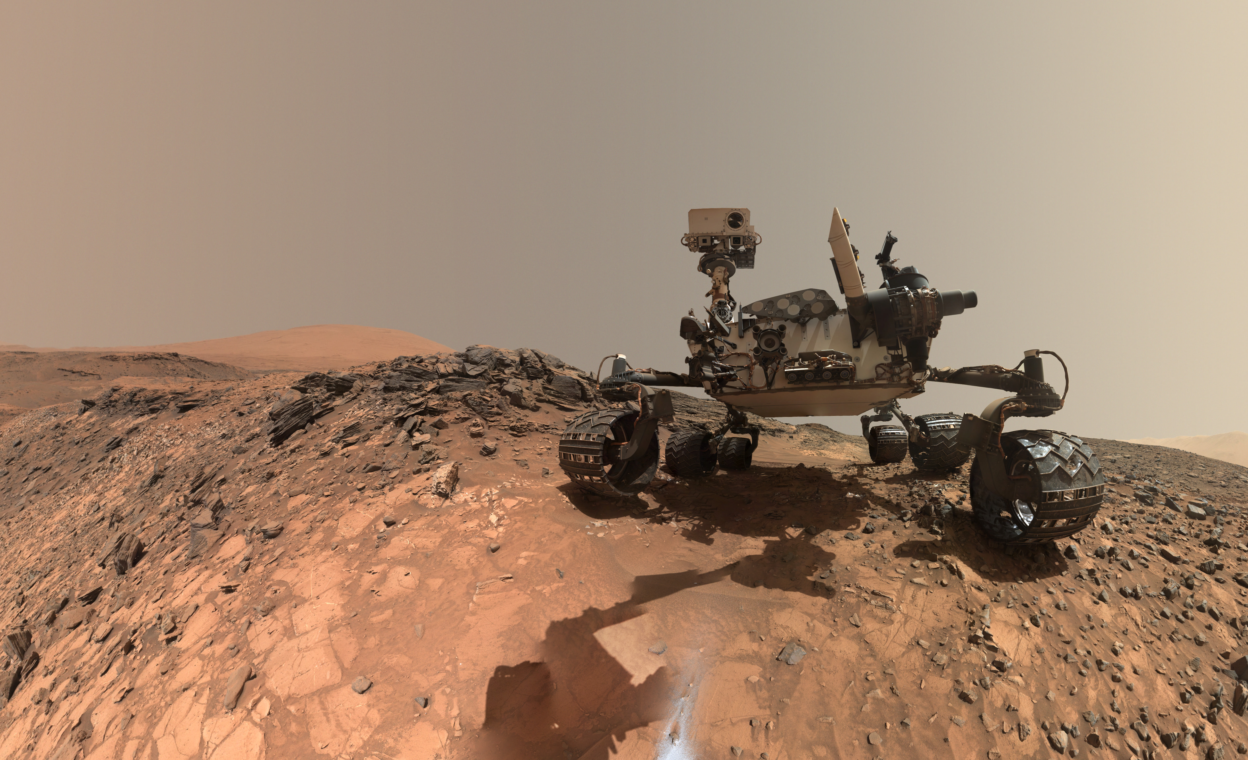
This low-angle self-portrait of NASA's Curiosity Mars rover shows the vehicle at the site from which it reached down to drill into a rock target called "Buckskin." The MAHLI camera on Curiosity's robotic arm took multiple images on Aug. 5, 2015, that were stitched together into this selfie. Credits: NASA/JPL-Caltech/MSSS
This low-angle self-portrait of NASA’s Curiosity Mars rover shows the vehicle at the site from which it reached down to drill into a rock target called “Buckskin.” The MAHLI camera on Curiosity’s robotic arm took multiple images on Aug. 5, 2015, that were stitched together into this selfie. Credits: NASA/JPL-Caltech/MSSS
More selfie and drilling mosaics below[/caption]
The unique self portrait was taken from a low-angle for the first time and shows the six wheeled rover at work collecting her seventh drilled sample at the ‘Buckskin’ rock target earlier this month in the “Marias Pass” area of lower Mount Sharp.
‘Buckskin’ is also unique in a fabulously scientifically way because the rover discovered a new type of Martian rock that’s surprisingly rich in silica – and unlike any other targets found before.
The low camera angle is what enables the awesome Buckskin belly selfie. It’s a distinctively dramatic view and actually stitched from 92 images captured by the Mars Hand Lens Imager (MAHLI) on Aug. 5, 2015, or Sol 1065 of the mission.
The high resolution MAHLI color camera is located on the end of the 7 foot-long (2.1 meter-long) robotic arm.
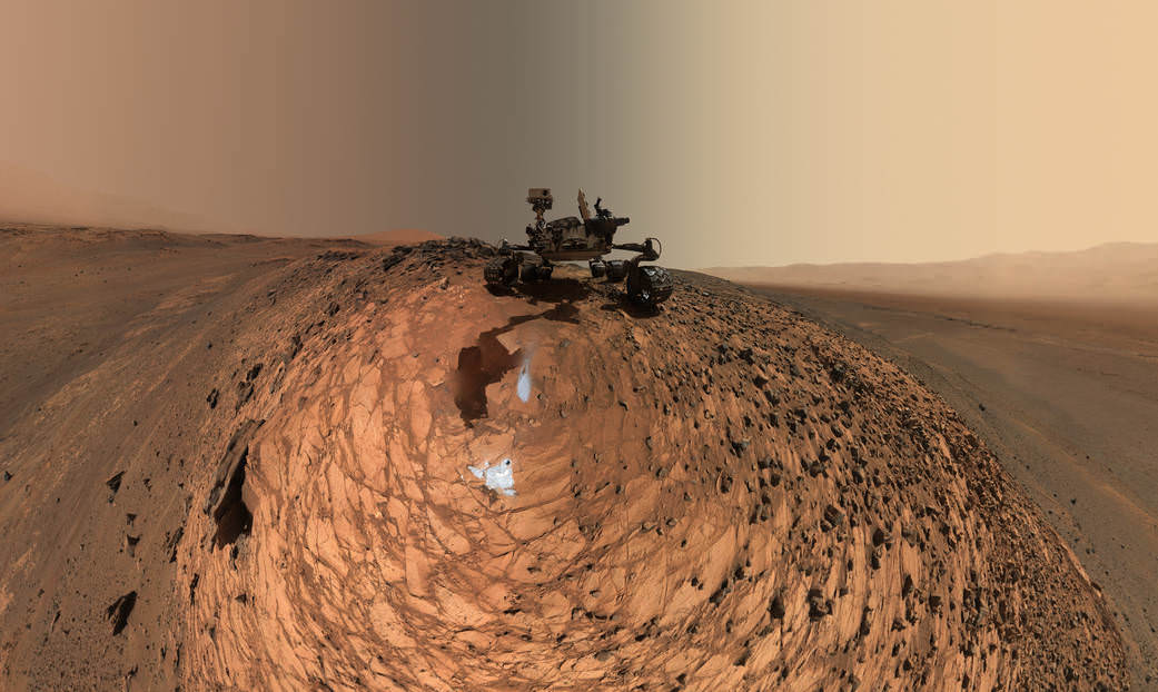
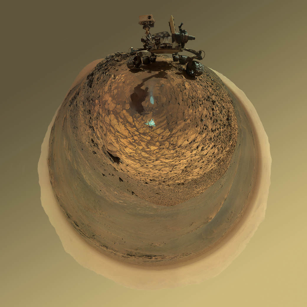
This version of a self-portrait of NASA’s Curiosity Mars rover at a drilling site called “Buckskin” is presented as a stereographic projection, which shows the horizon as a circle. The MAHLI camera on Curiosity’s robotic arm took dozens of component images for this selfie on Aug. 5, 2015. Credits: NASA/JPL-Caltech/MSSS
Indeed the car-sized rover has taken spectacular selfies several times before during her three year long trek across the Martian surface, since the August 2012 landing inside Mars’ Gale Crater. But for those past selfies the MAHLI camera was hoisted higher to give the perspective of looking somewhat downward and showing the rovers top deck and trio of sample inlet ports.
In this case, the rover team specifically commanded Curiosity to position “the camera lower in relation to the rover body than for any previous full self-portrait of Curiosity,” said NASA officials.
Two patches of gray colored powdered rock material drilled from Buckskin are visible in the selfie scene, in front of the rover.
“The patch closer to the rover is where the sample-handling mechanism on Curiosity’s robotic arm dumped collected material that did not pass through a sieve in the mechanism. Sieved sample material was delivered to laboratory instruments inside the rover. The patch farther in front of the rover, roughly triangular in shape, shows where fresh tailings spread downhill from the drilling process.”
Prior selfies were taken at the “Rocknest” (http://photojournal.jpl.nasa.gov/catalog/PIA16468), “John Klein” (http://photojournal.jpl.nasa.gov/catalog/PIA16937), “Windjana” (http://photojournal.jpl.nasa.gov/catalog/PIA18390) and “Mojave” drill sites.
Basically in the Sol 1065 belly selfie at “Buckskin” we see the underbelly of the rover and all six wheels along with a complete self portrait.
This version of a self-portrait of NASA’s Curiosity Mars rover at a drilling site called “Buckskin” is presented as a stereographic projection, which shows the horizon as a circle. The MAHLI camera on Curiosity’s robotic arm took dozens of component images for this selfie on Aug. 5, 2015. Credits: NASA/JPL-Caltech/MSSS
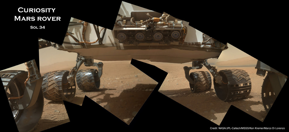
On several prior occasions, MAHLI was used to image just the underbelly and wheels to aid in inspecting the wheels to look for signs of damage inflicted by sharp-edged Martian rocks poking holes in the aluminum wheels.
Underbelly view of Curiosity rover and wheels on Sol 34, Sept. 9, 2012. Credit: NASA/JPL/MSSS/Ken Kremer/Marco Di Lorenzo
Each wheel measures 20 inches (50 centimeters) in diameter and about 16 inches (40 centimeters) wide. And the MAHLI monitoring images have shown the effects of increasing wear and tear that ultimately forced the rover drivers to alter Curiosity’s driving route on the crater floor in favor of smoother and less rocky terrain imparting less damage to the critical wheels.
If you take a close look at the new selfie up top, you’ll see a small rock stuck onto Curiosity’s left middle wheel (on the right in this head-on view). The rock was seen also in prior wheel monitoring images taken three weeks ago.
“The selfie at Buckskin does not include the rover’s robotic arm beyond a portion of the upper arm held nearly vertical from the shoulder joint. With the wrist motions and turret rotations used in pointing the camera for the component images, the arm was positioned out of the shot in the frames or portions of frames used in this mosaic,” according to officials.
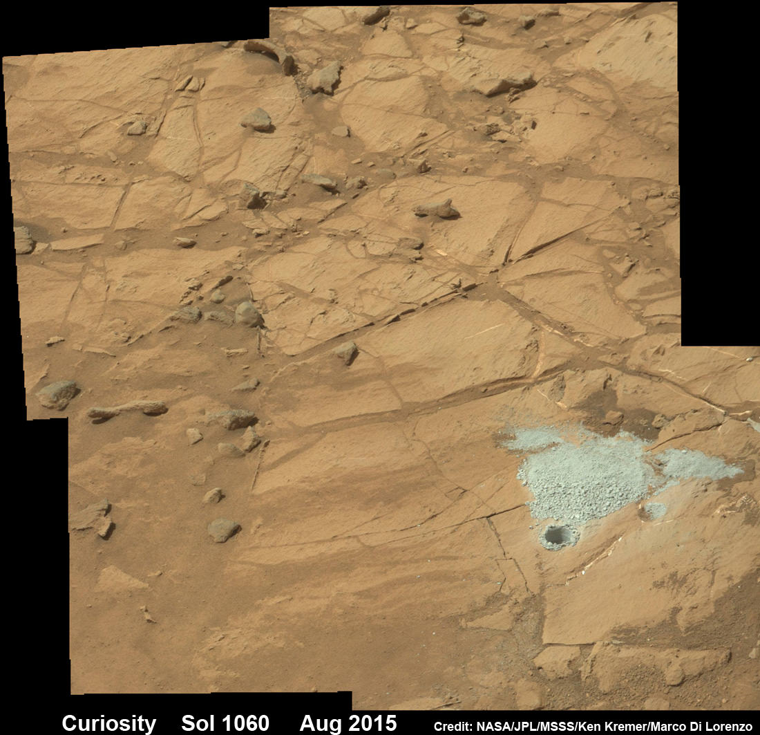
The drilling campaign into “Buckskin” was successfully conducted on Sol 1060 (July 30, 2015) at the bright toned “Lion” outcrop to a full depth of about 2.6 inches (6.5 centimeters) and approximately 1.6 cm (0.63 inch) diameter.
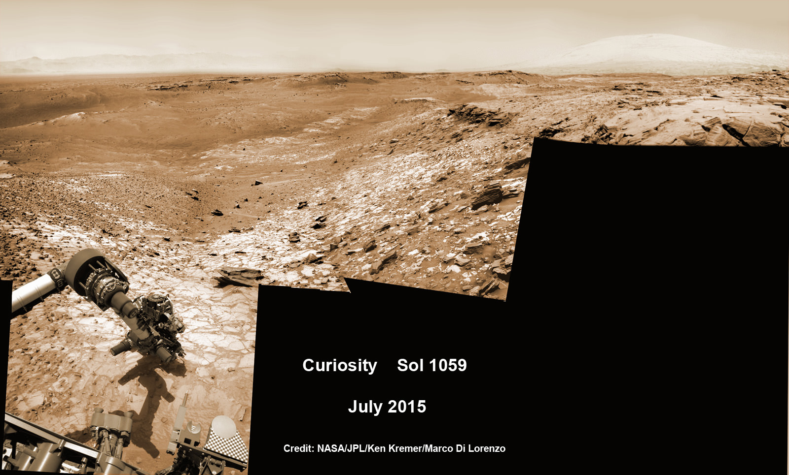
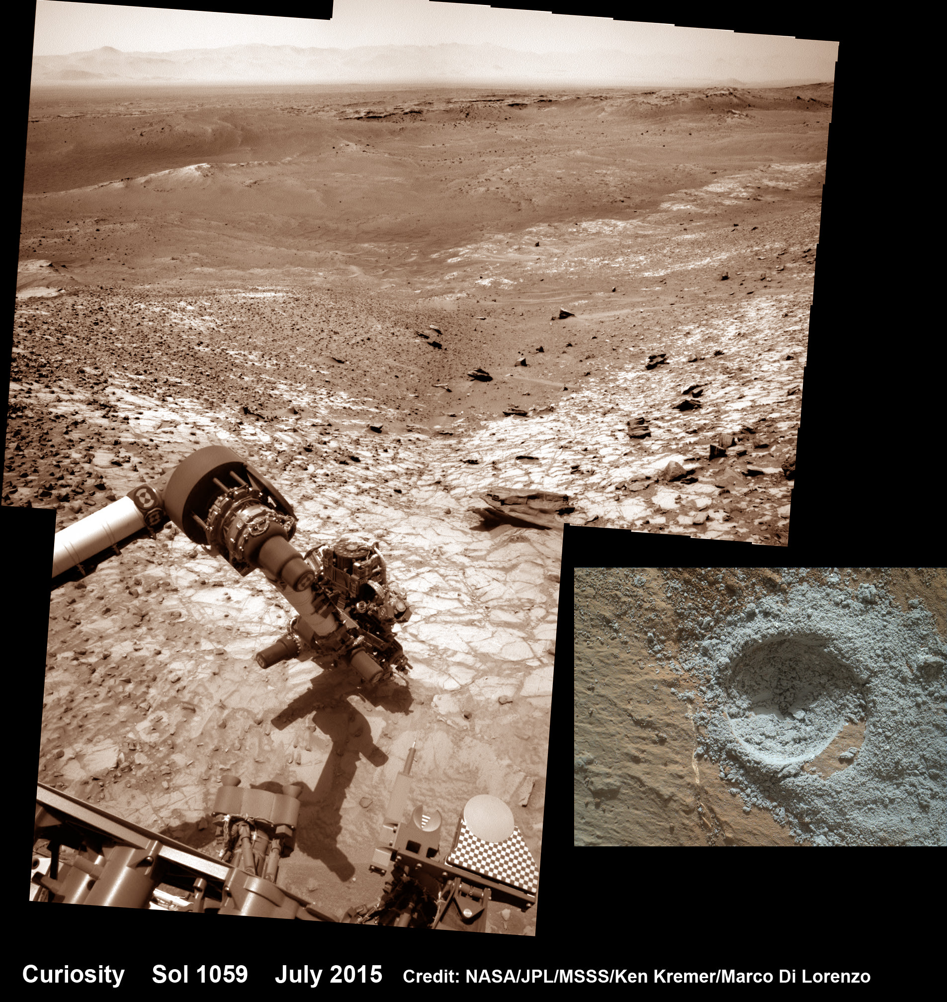
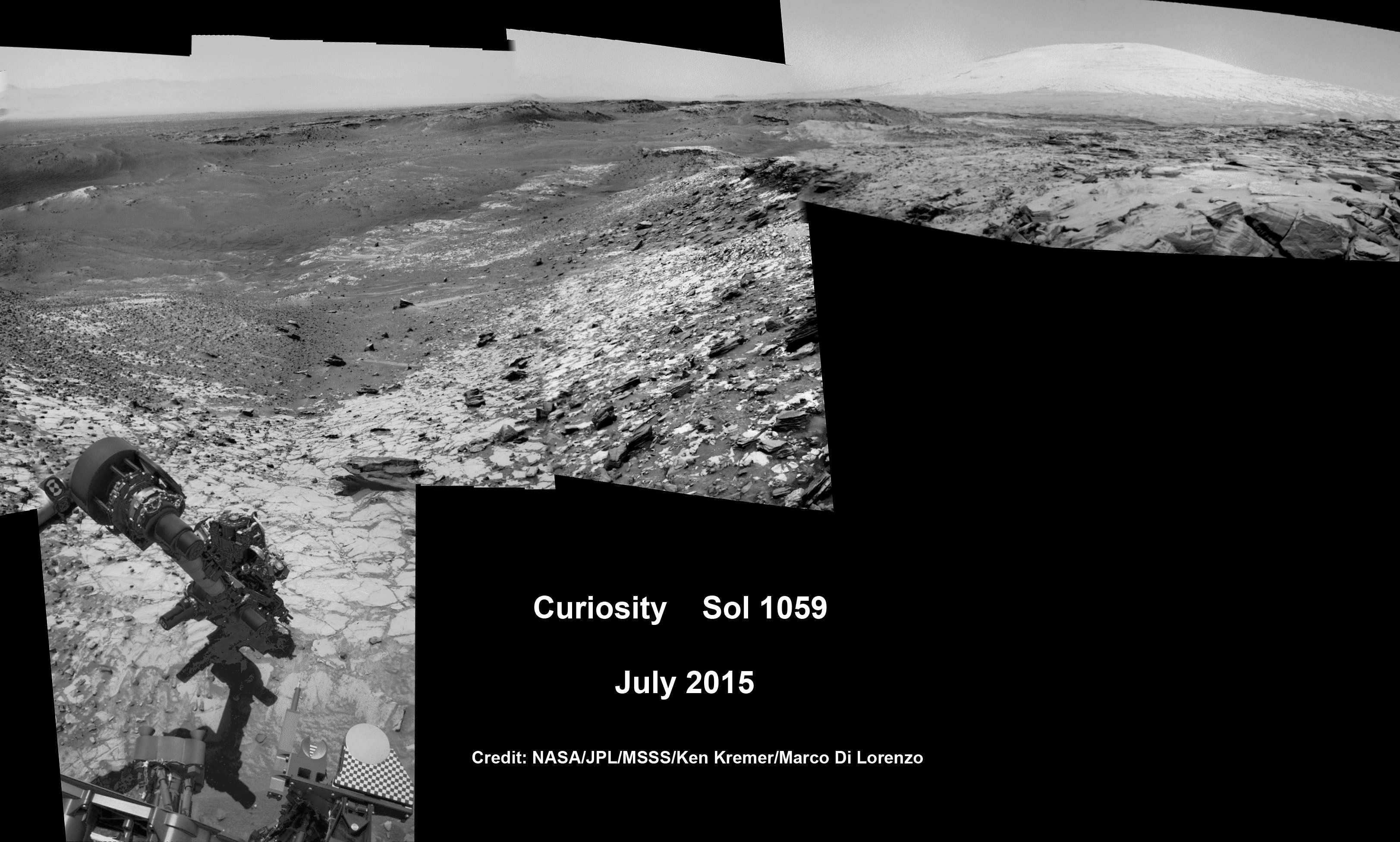
Curiosity extends robotic arm and conducts sample drilling at “Buckskin” rock target at bright toned “Lion” outcrop at the base of Mount Sharp on Mars, seen at right. Gale Crater eroded rim seen in the distant background at left, in this composite multisol mosaic of navcam raw images taken to Sol 1059, July 30, 2015. Navcam camera raw images stitched and colorized. Inset: MAHLI color camera up close image of full depth drill hole at “Buckskin” rock target on Sol 1060. Credit: NASA/JPL-Caltech/MSSS/Ken Kremer/kenkremer.com/Marco Di Lorenzo
You can also see another perspective of the rover at work while reaching out with the robotic arm and drilling into ‘Buckskin’ as illustrated in our mosaics of mastcam and navcam camera raw images created by the image processing team of Ken Kremer and Marco Di Lorenzo.
The main bore hole was drilled next to the initial mini hole test and shows the indicative residue of grey colored tailings from the Martian subsurface seen distributed around the new hole.
Curiosity rover successfully drills into Martian outcrop at Buckskin rock target at current work site at base of Mount Sharp in August 2015, in this mosaic showing full depth drill hole and initial test hole, with grey colored subsurface tailings and mineral veins on surrounding Red Planet terrain. This high resolution photo mosaic is a multisol composite of color images taken by the mast mounted Mastcam-100 color camera up to Sol 1060, July 31, 2015. Credit: NASA/JPL-Caltech/Ken Kremer/kenkremer.com/Marco Di Lorenzo
Curiosity has now moved on from the “Marias Pass” area.
As of today, Sol 1080, August 20, 2015, she has driven some 6.9 miles (11.1 kilometers) kilometers and taken over 260,000 amazing images.
Curiosity rover scans toward south east around Marias Pass area at the base of Mount Sharp on Mars on Sol 1074, Aug. 14, 2015 in this photo mosaic stitched from Mastcam color camera raw images. Credit: NASA/JPL/MSSS/Marco Di Lorenzo/Ken Kremer/kenkremer.com
Curiosity has already accomplished her primary objective of discovering a habitable zone on the Red Planet – at the Yellowknife Bay area – that contains the minerals necessary to support microbial life in the ancient past when Mars was far wetter and warmer billions of years ago.
Stay tuned here for Ken’s continuing Earth and planetary science and human spaceflight news.
The intriguing brightest spots on Ceres lie in a crater named Occator, which is about 60 miles (90 kilometers) across and 2 miles (4 kilometers) deep. Vertical relief has been exaggerated by a factor of five. Exaggerating the relief helps scientists understand and visualize the topography much more easily, and highlights features that are sometimes subtle. Credits: NASA/JPL-Caltech/UCLA/MPS/DLR/IDA/LPI
Video caption: Take a tour of weird Ceres! Visit a 2-mile-deep crater and a 4-mile-tall mountain in the video narrated by mission director Marc Rayman. Get your red/blue glasses ready for the finale – a global view of the dwarf planet in 3D. Credits: NASA/JPL-Caltech/UCLA/MPS/DLR/IDA/LPI/PSI
Mysterious bright spots and a pyramidal shaped mountain star in a daunting new flyover video of dwarf planet Ceres created from imagery gathered by NASA’s history making Dawn mission – the first ever to visit any dwarf planet which simultaneously ranks as the largest world in the main asteroid belt residing between Mars and Jupiter.
Ceres was nothing more than a fuzzy blob to humankinds most powerful telescopes like the Hubble Space Telescope (HST), until the probe swooped in this year and achieved orbit on March 6, 2015.
The newly released, stunning video takes takes you on a tour like none before for a global cruise over the most fascinating features on Ceres – including the 2-mile-deep (4-km-deep) crater dubbed Occator and a towering 4-mile-tall (6 kilometer-tall) mountain as tall as any in North America.
The spectacular flyover animation was generated from high resolution images taken by Dawn’s framing camera during April and May and is narrated by Marc Rayman, Dawn Chief Engineer and Mission Director of NASA’s Jet Propulsion Laboratory, Pasadena, California.
The video concludes with a 3D view, so you’ll need to whip out your handy red/blue glasses for the finale – a global view of the dwarf planet in 3D.
From the orbital altitude at that time ranging from about 8,400 miles (13,600 kilometers) to 2,700 miles (4,400 kilometers), the highest-resolution regions on Ceres have a resolution of 1,600 feet (480 meters) per pixel.
Pockmarked Ceres is an alien world unlike any other in our solar system, replete with unexplained bright spots and craters of many sizes, large and small.
Occatur has captured popular fascination world-wide because the 60 miles (90 kilometers) diameter crater is rife with a host of the bodies brightest spots and whose nature remains elusive to this day, nearly half a year after Dawn arrived in orbit this past spring.
“Now, after a journey of 3.1 billion miles (4.9 billion kilometers) and 7.5 years, Dawn calls Ceres, home,” says Rayman.
The crater is named after the Roman agriculture deity of harrowing, a method of pulverizing and smoothing soil.
Dawn is an international science mission managed by NASA and equipped with a trio of science instruments from the US, Germany and Italy. The framing camera was provided by the Max Planck Institute for Solar System Research, Göttingen, Germany and the German Aerospace Center (DLR).
The visible and infrared mapping spectrometer (VIR), provided by Italy is an imaging spectrometer that examines Ceres in visible and infrared light.
Dawn’s science team is using the instruments to investigate the light reflecting from Occator at different wavelengths.
From a distance, the crater appeared to be home to a duo of bright spots that looked like a pair of eyes. As Dawn moves ever closer, they became more resolved and now are split into dozens of smaller bright spots.
Global view of Ceres uses data collected by NASA’s Dawn mission in April and May 2015. The highest-resolution parts of the map have a resolution of 1,600 feet (480 meters) per pixel. Credits: NASA/JPL-Caltech/UCLA/MPS/DLR/IDA/LPI/PSI
Although some early speculation centered on the spots possibly being consistent with water ice or salts, newly gathered data “has not found evidence that is consistent with ice. The spots’ albedo -¬ a measure of the amount of light reflected -¬ is also lower than predictions for concentrations of ice at the surface,” according to the scientists.
“The science team is continuing to evaluate the data and discuss theories about these bright spots at Occator,” said Chris Russell, Dawn’s principal investigator at the University of California, Los Angeles, in a statement.
“We are now comparing the spots with the reflective properties of salt, but we are still puzzled by their source. We look forward to new, higher-resolution data from the mission’s next orbital phase.”
Occator lies in Ceres northern hemisphere.
The huge pyramidal mountain lies farther to the southeast of Occator – at 11 degrees south, 316 degrees east.
Based on the latest calculations, the mountain sits about 4 miles (6 kilometers) high, with respect to the surface around it. That make it roughly the same elevation as Mount McKinley in Denali National Park, Alaska, the highest point in North America.
Among the highest features seen on Ceres so far is a mountain about 4 miles (6 kilometers) high, which is roughly the elevation of Mount McKinley in Alaska’s Denali National Park. Vertical relief has been exaggerated by a factor of five to help understand the topography. Credits: NASA/JPL-Caltech/UCLA/MPS/DLR/IDA/LPI
The Texas-sized world is slightly smaller than previously thought. Based on new measurements from Dawn, Ceres’ average diameter to 584 miles (940 kilometers), compared to earlier estimates of 590 miles (950 kilometers).
Dawn made history in March when it simultaneously became the first probe from Earth to reach Ceres as well as the first spacecraft to orbit two extraterrestrial bodies.
It had previously visited Vesta. After achieving orbit in July 2011, Dawn became the first spacecraft from Earth to orbit a body in the main Asteroid Belt.
In sharp contrast to rocky Vesta, Ceres is an icy world.
Scientists believe that Ceres may harbor an ocean of subsurface liquid water as large in volume as the oceans of Earth below a thick icy mantle despite its small size – and thus could be a potential abode for life. Overall Ceres is estimated to be about 25% water by mass.
“We really appreciate the interest in our mission and hope they are as excited as we have been about these scientific surprises,” Russell told Universe Today.
“Since we are only just beginning our investigation, I expect that there will be more surprises. So please stick with us!”
As Dawn spirals down to a lower orbit of about 1,200 miles (1,900 km) above Ceres (and then even lower) using its ion engines, new answers and new mysteries are sure to be forthcoming.
“There are many other features that we are interested in studying further,” said Dawn science team member David O’Brien, with the Planetary Science Institute, Tucson, Arizona.
“These include a pair of large impact basins called Urvara and Yalode in the southern hemisphere, which have numerous cracks extending away from them, and the large impact basin Kerwan, whose center is just south of the equator.”
The mission is expected to last until at least June 2016 depending upon fuel reserves.
Dawn was launched on September 27, 2007 by a United Launch Alliance (ULA) Delta II Heavy rocket from Space Launch Complex-17B (SLC-17B) at Cape Canaveral Air Force Station, Florida.
Stay tuned here for Ken’s continuing Earth and planetary science and human spaceflight news.
Curiosity extends robotic arm and conducts test drill at “Buckskin” rock target at bright toned “Lion” outcrop on the lower region of Mount Sharp on Mars, seen at right. Gale Crater eroded rim seen in the distant background at left, in this composite multisol mosaic of navcam raw images taken to Sol 1059, July 30, 2015. Navcam camera raw images stitched and colorized. Credit: NASA/JPL-Caltech/Ken Kremer/kenkremer.com/Marco Di Lorenzo
On the eve of the 3rd anniversary since her nail biting touchdown inside Gale Crater, NASA’s car sized Curiosity Mars Science Laboratory (MSL) rover has discovered a new type of Martian rock that’s surprisingly rich in silica – and unlike any other targets found before.
Excited by this new science finding on Mars, Curiosity’s handlers are now gearing the robot up for her next full drill campaign today, July 31 (Sol 1060) into a rock target called “Buckskin” – which lies at the base of Mount Sharp, the huge layered mountain that is the primary science target of this Mars rover mission.
“The team selected the “Buckskin” target to drill,” says Lauren Edgar, Research Geologist at the USGS Astrogeology Science Center and an MSL science team member, in a mission update.
See the rover at work reaching out with her robotic arm and drilling into Buckskin, as illustrated in our new mosaics of navcam camera images created by the image processing team of Ken Kremer and Marco Di Lorenzo (above and below). Also featured at Alive Universe Images – here.
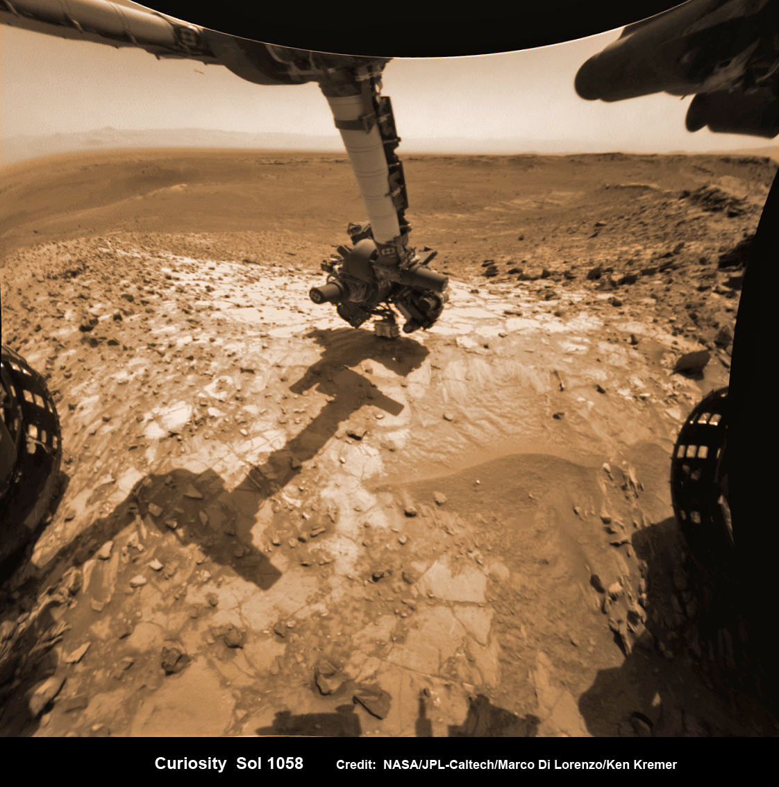
NASA Curiosity rover inspects ‘Buckskin’ rock outcrop on Mars with APXS mineral spectrometer in this hazcam camera raw image taken on July 29, 2015 (Sol 1058), colorized and linearized. Credit: NASA/JPL-Caltech/Marco Di Lorenzo/Ken Kremer/kenkremer.com
For about the past two months, the six wheeled robot has been driving around and exploring a geological contact zone named “Marias Pass” – an area on lower Mount Sharp, by examining the rocks and outcrops with her suite of state-of-the-art science instruments.
The goal is to provide geologic context for her long term expedition up the mountains sedimentary layers to study the habitability of the Red Planet over eons of time.
Data from Curiosity’s “laser-firing Chemistry & Camera (ChemCam) and Dynamic Albedo of Neutrons (DAN), show elevated amounts of silicon and hydrogen, respectively,” in certain local area rocks, according to the team.
Silica is a rock-forming compound containing silicon and oxygen, commonly found on Earth as quartz.
“High levels of silica could indicate ideal conditions for preserving ancient organic material, if present, so the science team wants to take a closer look.”
Curiosity extends robotic arm and conducts test drill at “Buckskin” rock target at bright toned “Lion” outcrop on the lower region of Mount Sharp on Mars. Gale crater rim seen in the distant background, in this composite mosaic of navcam raw images taken to Sol 1059, July 30, 2015. Inset: MAHLI camera up close image of test drill at “Buckskin” rock target. Navcam camera raw images stitched and colorized. Credit: NASA/JPL-Caltech/Ken Kremer/kenkremer.com/Marco Di Lorenzo Credit: NASA/JPL-Caltech/MSSS
Therefore the team scouted targets suitable for in depth analysis and sample drilling and chose “Buckskin”.
“Buckskin” is located among some high-silica and hydrogen enriched targets at a bright outcrop named “Lion.”
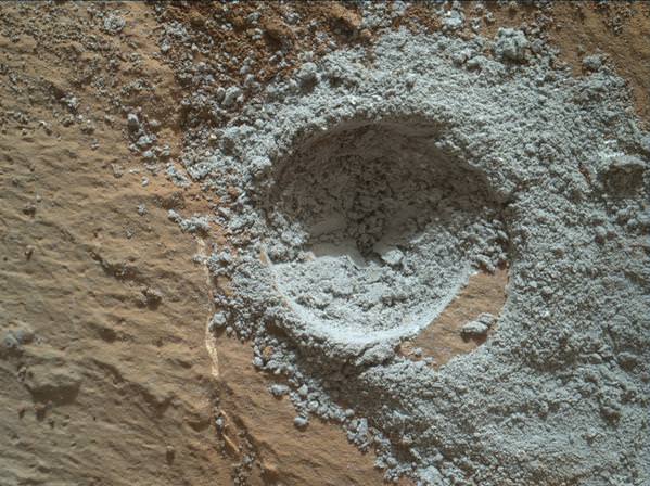
An initial test bore operation was conducted first to confirm whether that it was indeed safe to drill into “Buckskin” and cause no harm to the rover before committing to the entire operation.
The bore hole is about 1.6 cm (0.63 inch) in diameter.
“This test will drill a small hole in the rock to help determine whether it is safe to go ahead with the full hole,” elaborated Ryan Anderson, planetary scientist at the USGS Astrogeology Science Center and an MSL science team member.
So it was only after the team received back new high resolution imagery last night from the arm-mounted MAHLI camera which confirmed the success of the mini-drill operation, that the “GO” was given for a full depth drill campaign. MAHLI is short for Mars Hand Lens Imager.
“We successfully completed a mini drilling test yesterday (shown in the MAHLI image). That means that today we’re going for the FULL drill hole” Edgar confirmed.
“GO for Drilling.”
So it’s a busy day ahead on the Red Planet, including lots of imaging along the way to document and confirm that the drilling operation proceeds safely and as planned.
“First we’ll acquire MAHLI images of the intended drill site, then we’ll drill, and then we’ll acquire more MAHLI images after drilling,” Edgar explains.
“The plan also includes Navcam imaging of the workspace, and Mastcam imaging of the target and drill bit. In addition to drilling, we’re getting CheMin ready to receive sample in an upcoming plan. Fingers crossed!” Surface observations with the arm-mounted Alpha Particle X-ray Spectrometer (APXS) instrument are also planned.
If all goes well, the robot will process and pulverize the samples for eventual delivery to the onboard pair of miniaturized chemistry labs located inside her belly – SAM and CheMin. Tiny samples will be fed to the inlet ports on the rover deck through the sieved filters.
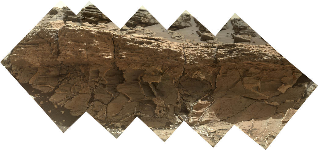
A rock outcrop dubbed “Missoula,” near Marias Pass on Mars, is seen in this image mosaic taken by the Mars Hand Lens Imager on NASA’s Curiosity rover. Pale mudstone (bottom of outcrop) meets coarser sandstone (top) in this geological contact zone, which has piqued the interest of Mars scientists. Credit: NASA/JPL-Caltech/MSSS
Meanwhile the team is studying a nearby rock outcrop called “Ch-paa-qn” which means “shining peak” in the native Salish language of northern Montana.”
Anderson says the target is a bright patch on a nearby outcrop. Via active and passive observations with the mast-mounted ChemCam laser and Mastcam multispectral imager, the purpose is to determine if “Ch-paa-qn” is comprised of calcium sulfate like other white veins visible nearby, or perhaps it’s something else entirely.
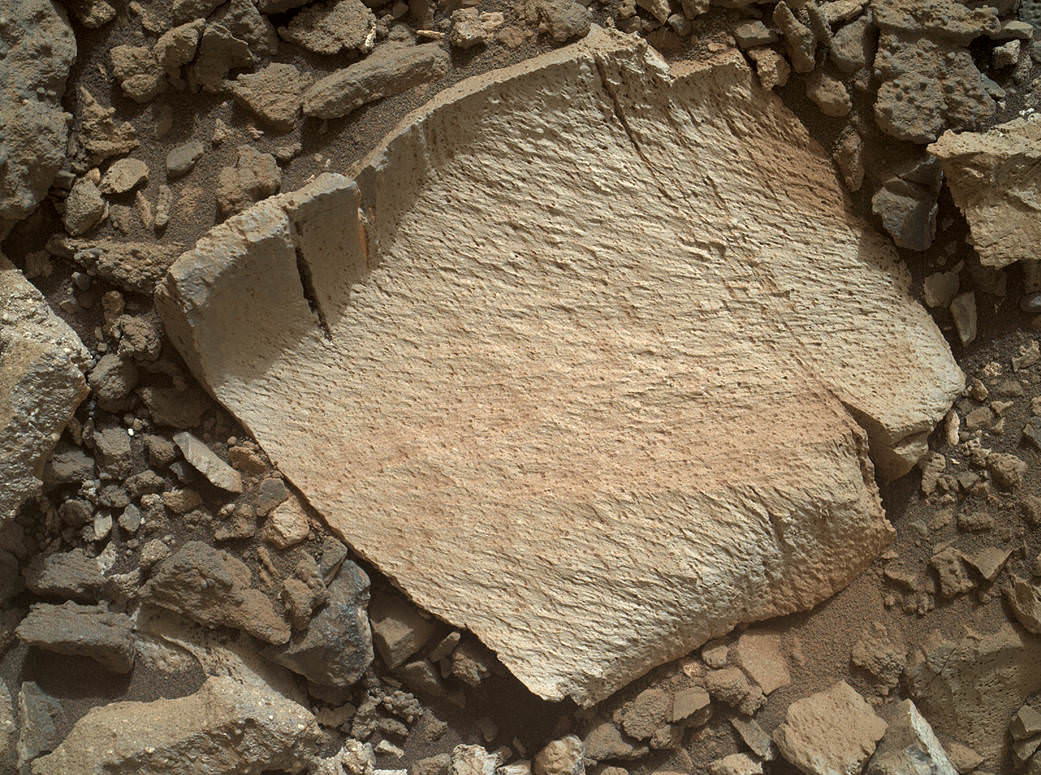
A rock fragment dubbed “Lamoose” is shown in this picture taken by the Mars Hand Lens Imager (MAHLI) on NASA’s Curiosity rover. Like other nearby rocks in a portion of the “Marias Pass” area of Mt. Sharp, Mars, it has unusually high concentrations of silica. The high silica was first detected in the area by the Chemistry & Camera (ChemCam) laser spectrometer. This rock was targeted for follow-up study by the MAHLI and the arm-mounted Alpha Particle X-ray Spectrometer (APXS). Credits: NASA/JPL-Caltech/MSSS
Before arriving by the “Lion” outcrop last week, Curiosity was investigating another outcrop area nearby, the high-silica target dubbed “Elk” with the ChemCam instrument, while scouting around the “Marias Pass” area in search of tasty science targets for in-depth analysis.
Sometimes the data subsequently returned and analyzed is so extraordinary, that the team decides on a return trip to a spot previously departed. Such was the case with “Elk” and the rover was commanded to do a U-turn to acquire more precious data.
“One never knows what to expect on Mars, but the Elk target was interesting enough to go back and investigate,” said Roger Wiens, the principal investigator of the ChemCam instrument from the Los Alamos National Laboratory in New Mexico.
Soon, ChemCam will have fired on its 1,000th target. Overall the laser blaster has been fired more than 260,000 times since Curiosity landed inside the nearly 100 mile wide Gale Crater on Mars on Aug. 6, 2012, alongside Mount Sharp.
“ChemCam acts like eyes and ears of the rover for nearby objects,” said Wiens.
“Marias Pass” is a geological context zone where two rock types overlap – pale mudstone meets darker sandstone.
The rover spotted a very curious outcrop named “Missoula.”
“We found an outcrop named Missoula where the two rock types came together, but it was quite small and close to the ground. We used the robotic arm to capture a dog’s-eye view with the MAHLI camera, getting our nose right in there,” said Ashwin Vasavada, the mission’s project scientist at NASA’s Jet Propulsion Laboratory in Pasadena, California.
White mineral veins, possibly comprised of calcium sulfate, filled the fractures by depositing the mineral from running groundwater.
“Such clues help scientists understand the possible timing of geological events,” says the team.
Read more about Curiosity in an Italian language version of this story at Alive Universe Images – here.
NASA’s Martian Curiosity rover looks backs to 1000 Sols of science and exploration on the surface of the Red Planet. Robot wheel tracks lead back through valley dunes. Gale Crater rim seen in the distant hazy background. Sol 997 (May 28, 2015) navcam camera raw images stitched and colorized. Credit: NASA/JPL-Caltech/ Marco Di Lorenzo/Ken Kremer/kenkremer.com Featured on APOD on June 13, 2015
As of today, Sol 1060, July 31, 2015, she has taken over 255,000 amazing images.
Red Mars, Gray Mars: “Mini-start hole” drill maneuver was successful. Image of mini start drill hole taken by Mars Hand Lens Imager (MAHLI) aboard NASA’s Mars rover Curiosity on July 30, 2015, Sol 1059. Credit: NASA/JPL-Caltech/MSSS
Curiosity extends robotic arm and conducts test drill at “Buckskin” rock target at bright toned “Lion” outcrop on the lower region of Mount Sharp on Mars, seen at right. Gale crater rim seen in the distant background at left, in this composite mosaic of navcam raw images taken to Sol 1059, July 30, 2015. Navcam camera raw images stitched. Credit: NASA/JPL-Caltech/Ken Kremer/kenkremer.com/Marco Di Lorenzo
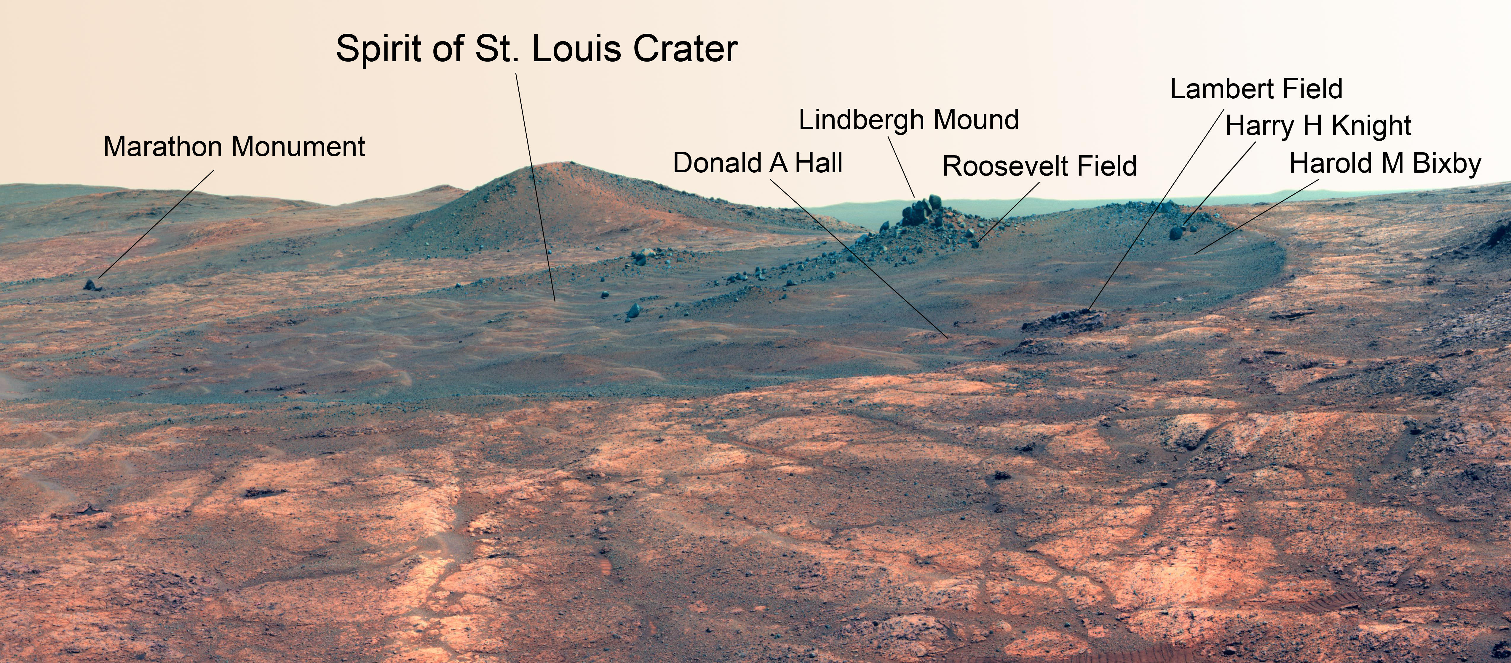
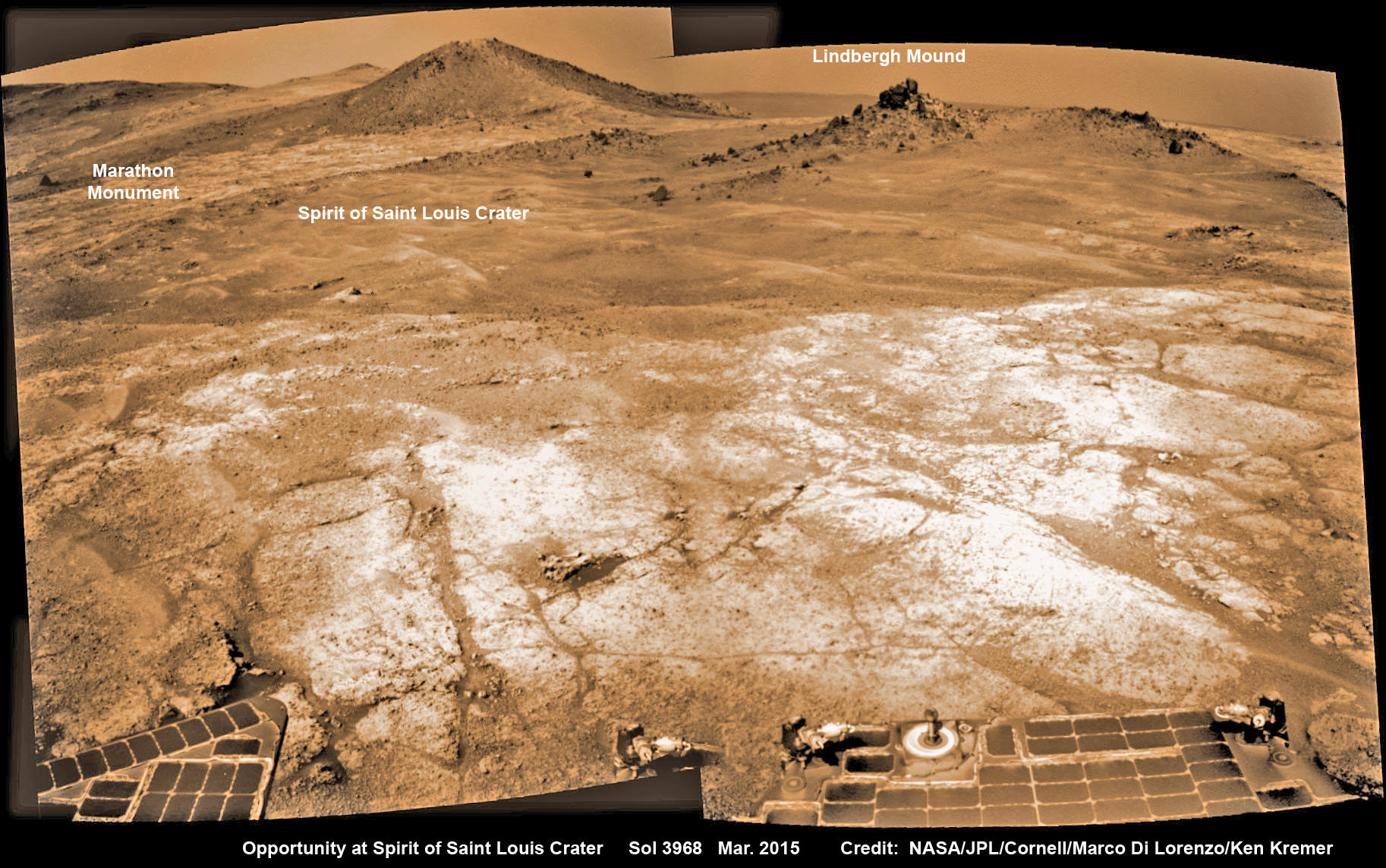
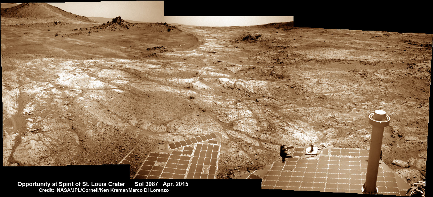
Martian Reminder of a Pioneering Flight. Names related to the first solo nonstop flight across the Atlantic have been informally assigned to a crater NASA's Opportunity Mars rover is studying. This false-color view of the "Spirit of St. Louis Crater" and the "Lindbergh Mound" inside it comes from Opportunity's panoramic camera. Image Credit: NASA/JPL-Caltech/Cornell Univ./Arizona State Univ.
Martian Reminder of a Pioneering Flight. Names related to the first solo nonstop flight across the Atlantic have been informally assigned to a crater NASA’s Opportunity Mars rover is studying. This false-color view of the “Spirit of St. Louis Crater” and the “Lindbergh Mound” inside it comes from Opportunity’s panoramic camera. Image Credit: NASA/JPL-Caltech/Cornell Univ./Arizona State Univ. See additional Opportunity photo mosaics below [/caption]
The science team leading NASA’s long-lived Opportunity rover mission is honoring the pioneering solo nonstop trans-Atlantic flight of aviator Charles Lindbergh by assigning key features of the Mars mountain top crater area the rover is now exploring with names related to the historic flight.
Opportunity is now studying an elongated crater called “Spirit of St. Louis” and an unparalleled rock spire within the crater called “Lindbergh Mound” which are named in honor of Lindbergh himself and his plane – the Spirit of Saint Louis.
“Spirit of Saint Louis” crater is quite special in many ways related not just to history but also to science and exploration – that very reasons behind Lindbergh’s flight and Opportunity’s astounding mission to the Red Planet.
The team is ecstatic that the 11 year old rover Opportunity has reached “Spirit of St. Louis Crater” because its serves as the gateway to the alien terrain of “Marathon Valley” holding caches of water altered minerals that formed under environmental conditions conducive to support Martian microbial life forms, if they ever existed.
The crater, rock spire and several features in and near it are shown in several recent panoramic mosaics, above and below, created by the rover team and separately by the image processing team of Ken Kremer and Marco Di Lorenzo.
Opportunity’s view (annotated) on the day the NASA rover exceeded the distance of a marathon on the surface of Mars on March 24, 2015, Sol 3968 with features named in honor of Charles Lindbergh’s historic solo flight across the Atlantic Ocean in 1927. Rover stands at Spirit of Saint Louis Crater near mountaintop at Marathon Valley overlook and Martian cliffs at Endeavour crater holding deposits of water altered clay minerals. This navcam camera photo mosaic was assembled from images taken on Sol 3968 (March 24, 2015) and colorized. Credit: NASA/JPL/Cornell/Marco Di Lorenzo/Ken Kremer/kenkremer.com
Marathon Valley and Spirit of St. Louis Crater are located just a few hundred meters south of a Mars mountain summit at a majestic spot called Cape Tribulation. It lies along a marvelous ridgeline along the western rim of Endeavour crater, which spans some 22 kilometers (14 miles) in diameter.
“What’s the connection between St. Louis and the Spirit of St. Louis? Lindbergh flew from New York to Paris, but he named his aircraft for the St. Louis citizens who purchased it for him,” says Prof. Ray Arvidson, the rover Deputy Principal Investigator of Washington University in St. Louis.
The raw images for the mosaics were taken in March and April 2015 using the robots mast mounted pancam and navcam cameras. The mosaics are shown in false color and colorized versions, annotated and unannotated.
Charles Lindbergh embarked in May 1927 on his history making flight from New York to Paris in the airplane he named Spirit of St. Louis, the first solo nonstop flight across the Atlantic.
Opportunity at Spirit of Saint Louis crater scanning into Marathon Valley and Endeavour crater from current location on Mars in April 2015 in this photo mosaic. The crater, featuring an odd mound of rocks now named Lingbergh Mound, is the gateway to Marathon Valley and exposures of water altered clay minerals. This navcam camera photo mosaic was assembled from images taken on Sol 3987 (April 12, 2015) and colorized. Credit: NASA/JPL/Cornell/ Ken Kremer/kenkremer.com/Marco Di Lorenzo
The shallow Spirit of St. Louis Crater is about 110 feet (34 meters) long and about 80 feet (24 meters) wide, with a floor slightly darker than surrounding terrain, says NASA.
Lindbergh Mound dominates the crater measuring about 7 to 10 feet (2 to 3 meters) tall, rising higher than the crater’s rim.
The annotations also include features named to recognize the financial backing for the flight from St. Louis residents including Harold M. Bixby and Harry M. Knight. The plane’s designer was Donald A. Hall.
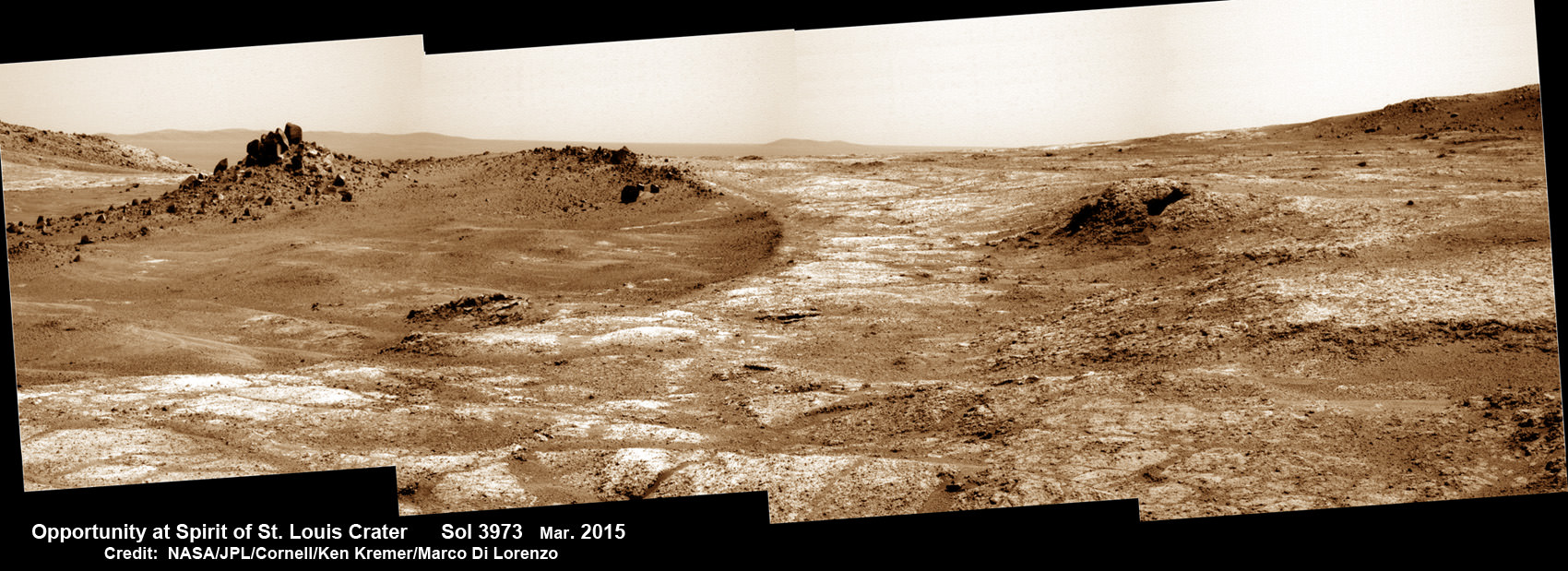
Opportunity arrives at Spirit of Saint Louis crater and peers into Marathon Valley and Endeavour crater from current location on Mars as of April 3, 2015 in this photo mosaic. The crater, featuring an odd mound of rocks now named Lingbergh Mound, is the gateway to Marathon Valley and exposures of water altered clay minerals. This pancam camera photo mosaic was assembled from images taken on Sol 3973 (March 29, 2015) and colorized. Credit: NASA/JPL/Cornell/ Ken Kremer/kenkremer.com/Marco Di Lorenzo
Among other features named are Roosevelt Field, the spot on New York’s Long Island from which Lindbergh took off, and Marathon Monument, where the rover completed a her first marathon distance runners drive on Mars. The team picked a distinctive outcrop, Marathon Monument, to mark the finish line, said NASA officials.
“The science team for the rover picks crater names from a list of “vessels of exploration,” including ships of sail and spacecraft as well as aircraft. As long as the rover remains in the crater, names for interesting features will drawn from a list of names related to this famous flight,” according to a NASA statement.
Stay tuned here for Ken’s continuing Earth and planetary science and human spaceflight news.
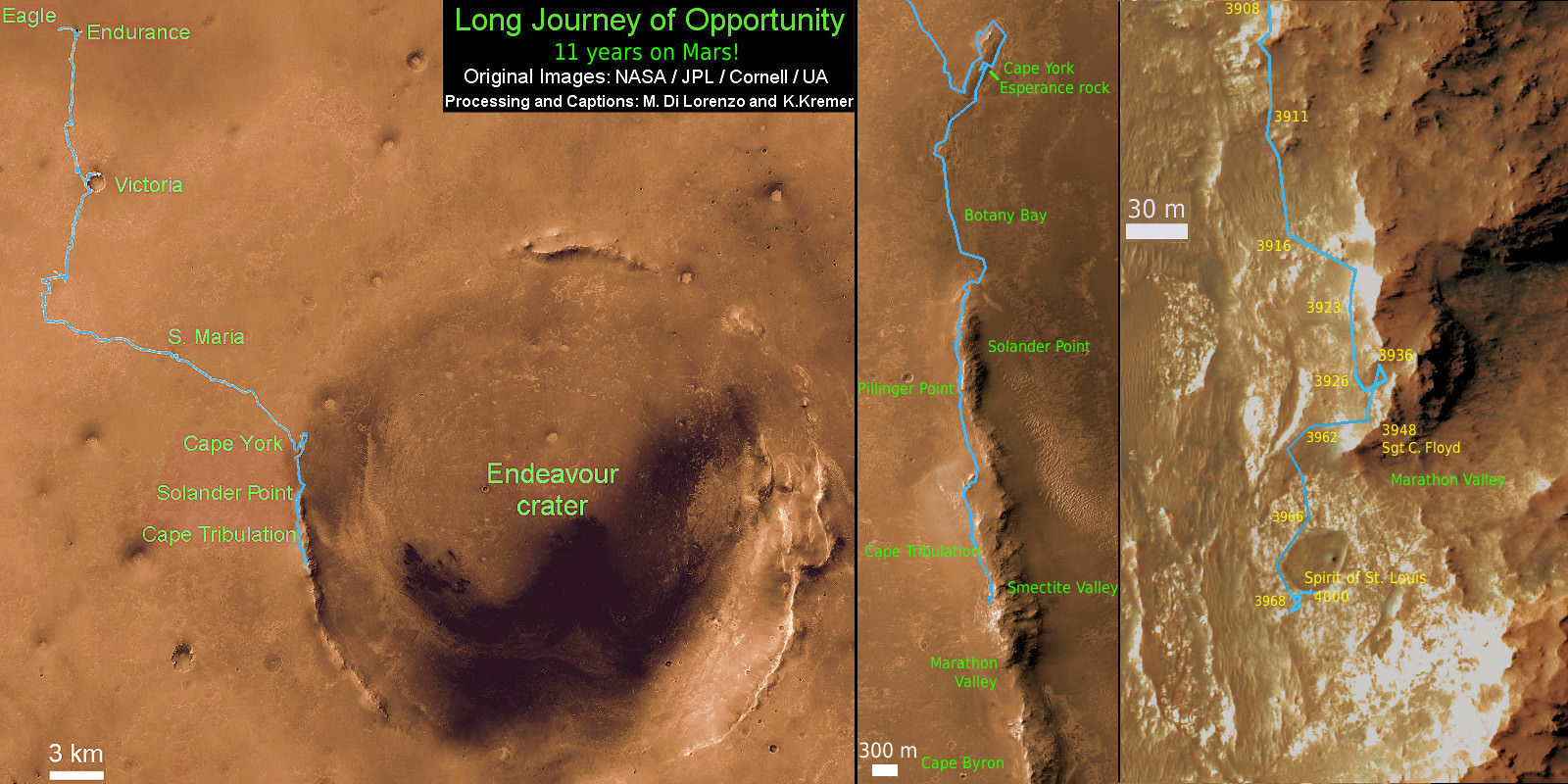
11 Year Traverse Map for NASA’s Opportunity rover from 2004 to 2015. This map shows the entire path the rover has driven during 11 years and three months and a marathon runners distance on Mars for over 4000 Sols, or Martian days, since landing inside Eagle Crater on Jan 24, 2004 -to current location just past the Cape Tribulation summit at the western rim of Endeavour Crater at Marathon Valley. Rover surpassed Marathon distance on Sol 3968 and marked 11th Martian anniversary on Sol 3911. Opportunity discovered clay minerals at Esperance – indicative of a habitable zone – and is searching for more on the road ahead at Marathon Valley. Credit: NASA/JPL/Cornell/ASU/Marco Di Lorenzo/Ken Kremer – kenkremer.com