Hurricane Joaquin captured on Oct. 2, 2015 by NASA Astronaut Scott Kelly from the International Space Station. Credit: NASA/Scott Kelly
As the powerful category 4 Hurricane Joaquin was pounding the Bahamas and packing winds of over 130 mph, NASA astronaut Scott Kelly captured a stunning photo of Joaquin on Friday morning, Oct. 2 from his perch aboard the International Space Station (ISS). As of today, Oct. 3. Joaquin has gained strength to 150 mph and is a borderline Cat 5 storm!
Kelly’s spectacular storm photo shows the eye of Hurricane Joaquin over the Caribbean and off the US eastern seaboard with the limb of the Earth and our atmosphere in beautiful detail.
Huge thunderstorms can been off to the north of the immense category 4 storm.
And as of today, Saturday, Oct. 3, Hurricane Joaquin has further strengthened and is now packing maximum sustained winds of 150 MPH or 240 KM/H, according to the latest advisory issued by the National Hurricane Center (NHC) as of 5 p.m. EDT.
Kelly posted the Oct. 2 photo of Joaquin with this caption on his twitter account:
“Early morning shot of Hurricane #Joaquin from @space_station before reaching #Bahamas. Hope all is safe. #YearInSpace.”
Two of the stations solar panels are seen in the photo as well as portions of the US east coast including Florida.
The latest NHC forecast shows Joaquin veering away from the US East Coast. But it’s still creating hurricane force winds and high waves that is threatening Bermuda.
“SEVERE HURRICANE JOAQUIN THREATENING BERMUDA,” said the NHC today.
It is moving northeast at 45 degrees at 17 MPH or 28 KM/H.
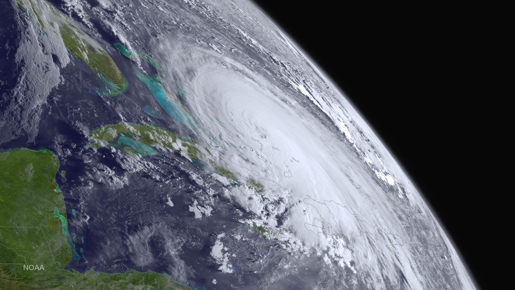
Kelly snapped another telling view of Joaquin on Thursday, Oct. 1 showing the Bahamas and Miami in the field of view.
Kelly tweeted; “#HurricaneJoaquin churns over the #Bahamas with #Miami in the field of view from @Space_Station.”
#HurricaneJoaquin churns over the #Bahamas with #Miami in the field of view from @Space_Station #YearInSpace. Credit: NASA/Scott Kelly
Scott Kelly is a member of the first ever 1 year ISS mission crew comprising Kelly and Russian cosmonaut Mikhail Kornienko.
They arrived at the ISS in March and had just reached the midpoint of their nearly 12 month stay aimed at conducting research to explore the impact of long term stays in space on the human body and aid NASA’s long term plans for a human‘Journey to Mars’ in the 2030s.
NASA and NOAA satellites are keeping constant watch on the progress of the powerful Hurricane Joaquin, that earlier had the potential to barrel towards tens of millions of US coastal residents.
Here’s another stunning view of Hurricane Joaquin taken by the GOES-West satellite on Oct. 1.
This stunning image of Hurricane Joaquin is from NOAA’s GOES West satellite on Oct. 1 2015. Many portions of the eastern U.S. are currently experiencing heavy rains and gusty winds associated with a frontal system. Credit: NOAA
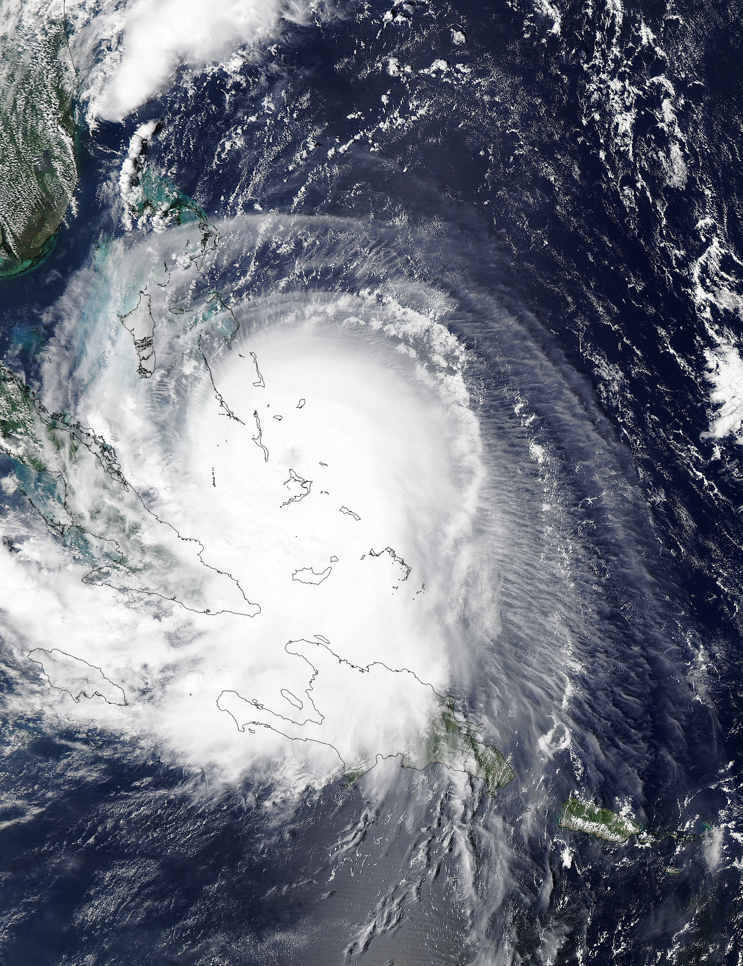
This visible image from NASA’s Aqua satellite shows Hurricane Joaquin over Bahamas on Oct. 1.
NASA’s Aqua satellite captured this visible image of Hurricane Joaquin over Bahamas on Oct. 1 at 17:55 UTC (1:55 p.m. EDT). Credits: NASA Goddard MODIS Rapid Response Team
Stay tuned here for Ken’s continuing Earth and planetary science and human spaceflight news.
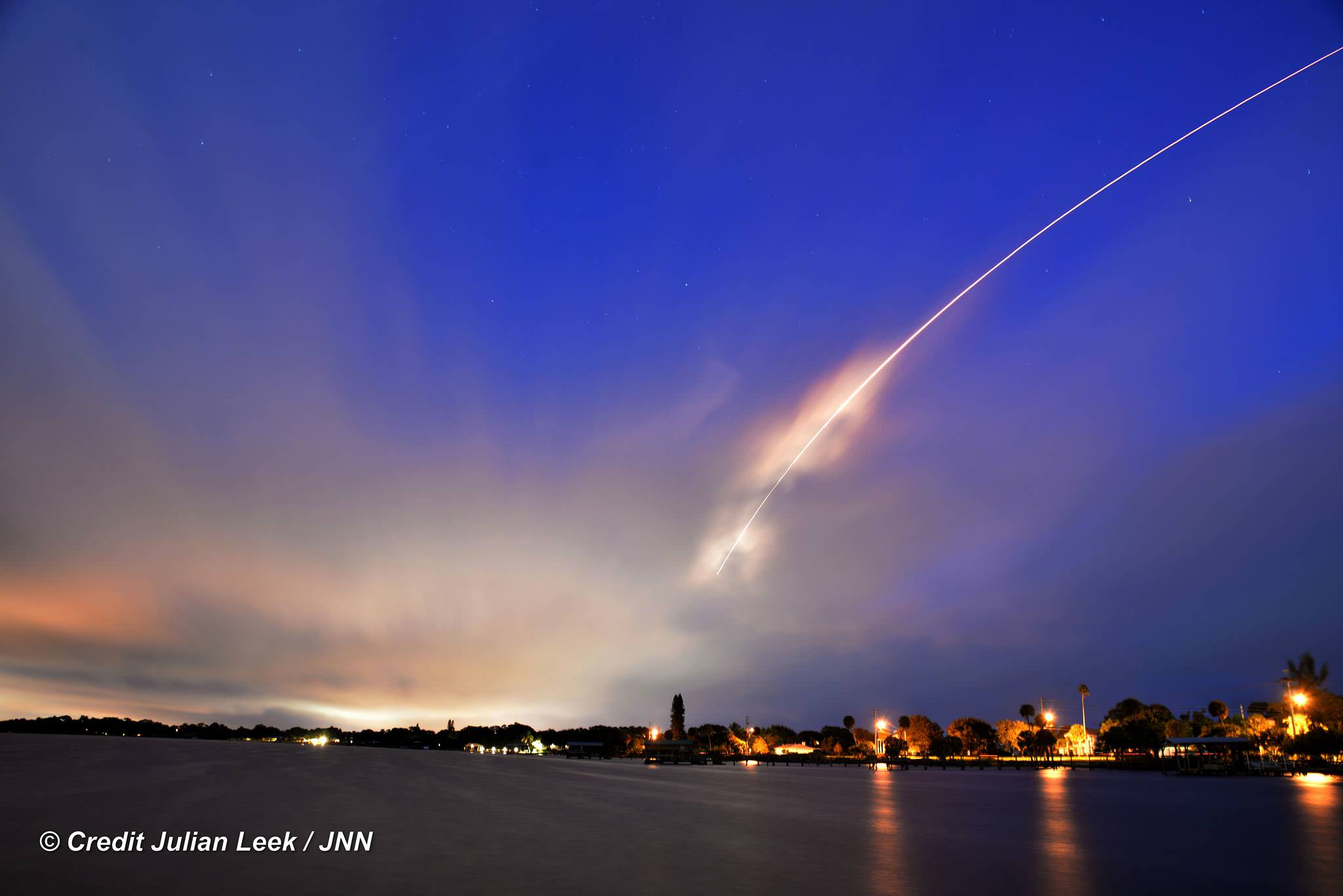
100th United Launch Alliance (ULA) rocket streaks to orbit with Atlas V booster carrying the Morelos-3 mission for Mexico from Space Launch Complex 41 on Cape Canaveral Air Force Station, Florida at 6:28 a.m. EDT, Oct. 2, 2015 as seen from Melbourne Beach pier, Florida. Credit: Julian Leek
100th United Launch Alliance (ULA) rocket streaks to orbit with Atlas V booster carrying the Morelos-3 mission for Mexico from Space Launch Complex 41 on Cape Canaveral Air Force Station, Florida at 6:28 a.m. EDT, Oct. 2, 2015 as seen from Melbourne Beach pier, Florida. Credit: Julian Leek See launch photo and video gallery below
United Launch Alliance (ULA) celebrated an incredible milestone today, Oct. 2, with the successful launch of the firms 100th mission on an Atlas V rocket carrying Mexico’s next generation Morelos-3 satellite to provide advanced telecommunications for education and health programs for rural communities and secure communications for Mexican national security needs.
NOAA's GOES-East satellite captured this visible image of Hurricane Joaquin affecting the Bahamas on Thursday, Oct. 1 at 1255 UTC. Credits: NASA/NOAA GOES Project
Video caption: This animation of images captured from September 29 to October 1, 2015 from NOAA’s GOES-East satellite shows Hurricane Joaquin become a major hurricane in the Bahamas. Credits: NASA/NOAA GOES Project
NEW JERSEY – A wide swath of the US East Coast is bracing for impact in the coming days as ‘Hurricane Joaquin’ strengthened to a major and dangerous Category 4 storm, today, Thursday, Oct. 1, as NASA and NOAA satellites keep constant watch as it barrels potentially towards tens of millions of coastal residents.
Joaquin is already packing winds exceeding 130 mph with even higher wind gusts as the storm continues to strengthen at this hour and the pressure is decreasing. See the latest Hurricane Joaquin animation and imagery from NASA and NOAA, above and below.
A ULA Atlas V is slated to lift off Friday from Cape Canaveral Air Force Station in Florida at 6:08 a.m. EDT with the Morelos-3 communications satellite for Mexico, before the hurricane gets closer to Florida.
The National Hurricane Center declared Joaquin had intensified into a massive Category 4 hurricane on the Saffir-Simpson Wind Scale, as of 2 PM EDT today, Oct. 1.
You can watch the launch on ULA’s live webcast starting at 5:48 a.m. Oct 2: http://www.ulalaunch.com
The governors of three states – New Jersey, Virginia and North Carolina – have already declared ‘States of Emergency’ in anticipation of potentially destructive winds, potentially life threatening drenching rains and floods, downed power lines and ocean rip currents with high waves in local areas.
Multiple NASA and NOAA satellites are intensively and continuously observing Joaquin, and are providing absolutely critical data to forecasters and government officials with the most current and best information available.
NASA’s GPM, Terra and NPP-Suomi satellites and NOAA’s GOES-East satellite are tracking Joaquin and have seen powerful thunderstorms today which indicates continued strengthening.
At this time we still don’t whether the US eastern seaboard will suffer a major hit but officials are taking no chances after suffering through Superstorm Sandy which caused many deaths, widespread power outages and billions and billions of dollars of damage – from which we are still recovering.
Joaquin is currently over The Bahamas in the Caribbean and is expected to make a sharp right turn on Friday Oct 2 and head northwards to the east coast and the Atlantic Ocean. It could start impacting the Carolinas and regions further north as soon as Sunday, Oct. 4, based on current forecasts, and drop double digits inches of torrential rainfall.
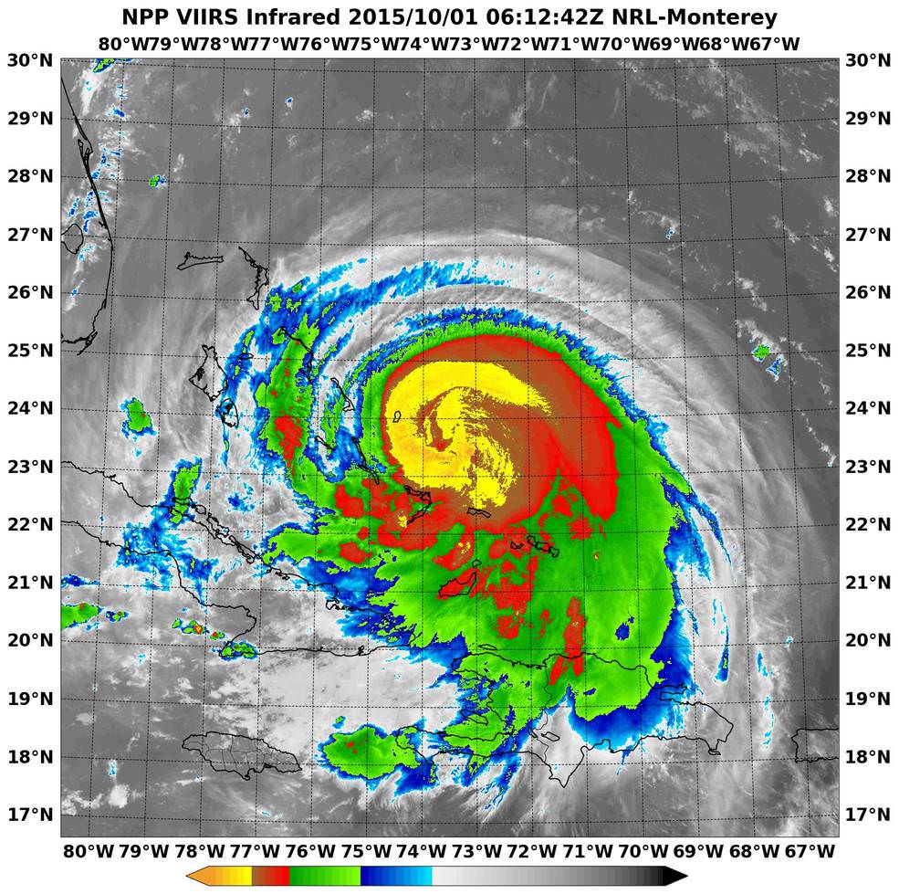
NASA-NOAA’s Suomi NPP satellite passed over Joaquin at 06:10 UTC (2:10 a.m. EDT) on Oct. 1 as it was strengthening from a Category 2 to a Category 3 hurricane. It’s now a Category 4. Imagery showed cloud top temperatures colder than -63F/-53C (yellow). Credits: NRL/NASA/NOAA
Its pounding the Bahamas right now and is creating a disaster with hurricane force winds and heavy rainfall, say weather forecasters, as it remains over the island for some 24 hours or more and may drop over 10 inches of rain.
But there is a very wide cone of uncertainly of where it could hit as the possible storm track extends from the Carolinas to Maine. It may or may not directly impact the eastern US. The storm may shift to the right and spare the east coast. But no one knows at this time.
Some areas on the US East coast stretching from Virginia to Maine have already suffered from torrential rains and severe flooding from an unrelated storm the past few days and also right now today, Thursday.
So the grounds are already saturated in parts of the Carolina’s, Virginia, Maine and elsewhere.
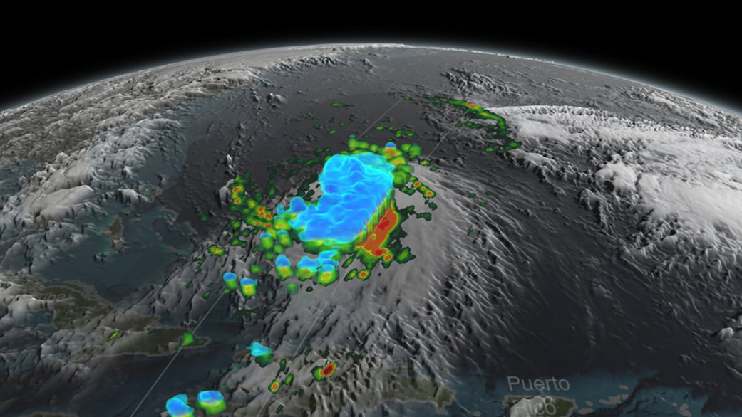
NASA/JAXA’s GPM satellite provided a 3-D side view of Tropical Storm Joaquin on Sept. 29 showing the internal precipitation structure. The areas in blue are frozen precipitation. Areas in green and red are liquid precipitation. Credits: Scientific Visualization Studio, NASA’s Goddard Space Flight Center
Coastal flood warnings and watches are already in effect in many areas along the eastern seaboard where local areas could be drenched by some 12 to 18 inches of additional rain which could fall even before the hurricane hits.
Significant beach erosion has already occurred in the Carolinas over the past few days and more is expected up and down the entire coast up to Maine.
And 10 foot high defense berms of sand are being constructed at this moment along miles and miles of the Jersey Shore – areas that suffered devastating damage from Superstorm Sandy.
There is a potential risk of deadly flooding, flash flooding and damage to houses, buildings, businesses, roadways and infrastructure.
“At 2 p.m. EDT (1800 UTC), the center of Hurricane Joaquin was located near latitude 23.0 North, longitude 74.2 West. Joaquin was moving generally southwestward at about 6 mph (9 kph), and the National Hurricane Center forecast a turn toward the northwest and north on Friday, Oct. 2. On the forecast track, the center of Joaquin will move near or over portions of the central Bahamas today and tonight and pass near or over portions of the northwestern Bahamas on Friday, Oct. 2,” according to NASAs Rob Gutro.
The weather forecast for Friday’s launch from Cape Canaveral , Florida is currently 70 percent GO for liftoff of the United Launch Alliance Atlas V rocket at 6:08 a.m. EDT. The Atlas V will launch with the Morelos-3 mission for Mexico’s Secretaria de Comunicaciones y Transportes (Ministry of Communications and Transportation).
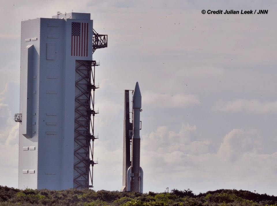
Morelos-3 will be part of the Mexsat constellation of satellites that delivers advanced telecommunications throughout Mexico. United Launch Alliance Atlas V rocket after rollout to Pad 41 at Cape Canaveral Air Force Station, Florida for planned Oct. 2 launch at 6:08 a.m. EDT with the Morelos-3 mission for Mexico’s Ministry of Communications and Transportation. In progress assembly of the commercial crew access tower is seen at right, now under construction for the Boeing Starliner space taxi for astronaut crews launching to the ISS. Credit: Julian Leek
Stay tuned here for Ken’s continuing Earth and planetary science and human spaceflight news.
United Launch Alliance Atlas V rocket during rollout to Space Launch Complex-41 at Cape Canaveral Air Force Station, Florida on Oct. 1 for planned Oct. 2 launch at 6:08 a.m. EDT with the Morelos-3 mission for Mexico’s Ministry of Communications and Transportation. Credit: Julian Leek