Swath of Destruction from Deadly Oklahoma Tornado Visible from Space

The track of the tornado that struck Moore, Oklahoma on May 20, 2013 is visible from space in this false color image taken on June 2, 2013 by the Advanced Spaceborne Thermal Emission and Reflection Radiometer (ASTER) on NASA’s Terra satellite.

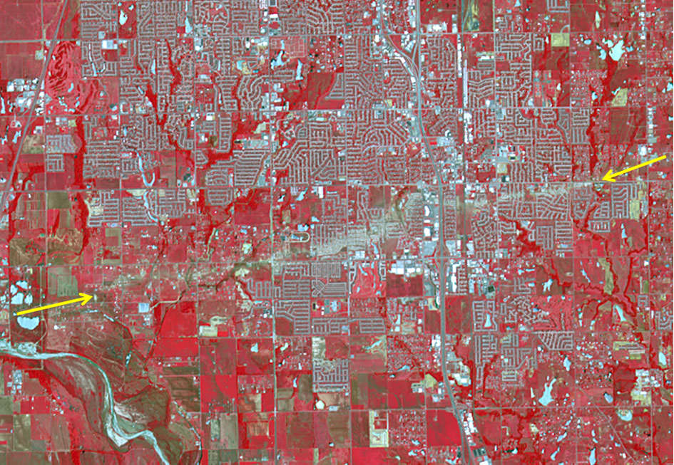
The tornado that devastated the region around Moore and Newcastle, Oklahoma on May 20, 2013 has been determined to be an EF-5 tornado, the most severe on the enhanced Fujita scale, and has been called one of the most powerful and destructive tornadoes ever recorded. In this new image taken by the Advanced Spaceborne Thermal Emission and Reflection Radiometer (ASTER) on NASA’s Terra satellite, the scar of destruction on the Oklahoma landscape is clearly visible from space. In this false-color infrared image, red highlights vegetation, and the tornado track appears as a beige strip running west to east across this image; the color reveals the lack of vegetation in the wake of the storm.

According to the National Weather Service, the tornado was on the ground for 39 minutes, ripping across 17 miles (27 kilometers) from 4.4 miles west of Newcastle to 4.8 miles east of Moore. At its peak, the funnel cloud was 1.3 miles (2.1 kilometers) wide and wind speeds reached 210 miles (340 km) per hour. The storm killed at least 24 people, injured 377, and affected nearly 33,000 in some way.

In this image, infrared, red, and green wavelengths of light have been combined to better distinguish between water, vegetation, bare ground, and human developments. Water is blue. Buildings and paved surfaces are blue-gray.

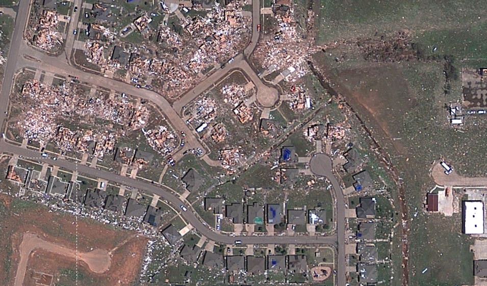
You can also see an interactive satellite map from Google and Digital Globe, showing detail of every building that was damaged or destroyed. Satellite data like this are helping to assist in the recovery and rebuilding of the area. Satellite imagery can provide a systematic approach to aiding, monitoring and evaluating the process.

Source: NASA Earth Observatory

Astonishing Hi-Resolution Satellite Views of the Destruction from the Moore, Oklahoma Tornado

Sceenshot of a satellite view from Google/Digital Globe of the destruction in Moore, Oklahoma after the May 20, 2013 tornado. Click image to have access to an interactive, zoomable version via NPR.

A new satellite map from Google and Digital Globe shows just-released satellite imagery of the damage from the tornado that struck the area of Moore, Oklahoma on May 20, 2013. It’s been called one of the most powerful and destructive tornadoes ever recorded — determined to be an EF5 tornado, the strongest rating for a tornado — and the destruction is heartbreaking. In the screenshot above, you can see how some houses were left undamaged, while others were completely destroyed.

Click on the image above to have access to an interactive map that shows hi-resolution views of the damage, providing details of where the buildings and houses once were. NPR put this map together, using satellite data from Digital Globe, along with property data from City of Oklahoma City, City of Moore, and Cleveland County. Satellite data like this are helping to assist the recovery and rescue teams on the ground.

In the immediate aftermath of a natural catastrophe such as this tornado, the priority is searching for survivors and saving lives.

But longer term recovery — including the rebuilding of infrastructure and amenities such as schools and hospitals — can take decades, and satellite imagery can provide a systematic approach to aiding, monitoring and evaluating this process.

Satellite view of the destructive tornado that passed just south of Oklahoma City. The Moderate Resolution Imaging Spectroradiometer (MODIS) on NASA’s Aqua satellite acquired this image of the storm at 2:40 p.m. local time (19:40 UTC) on May 20, 2013. Credit: NASA image courtesy Jeff Schmaltz, LANCE/EOSDIS MODIS Rapid Response Team at NASA GSFC.

See more satellite views from NASA of the storm and aftermath on NASA Goddard’s Flickr page for this tornado.

The Take Part website has a list of organizations that are providing support for the recovery and care of the people affected, if you would like to contribute.