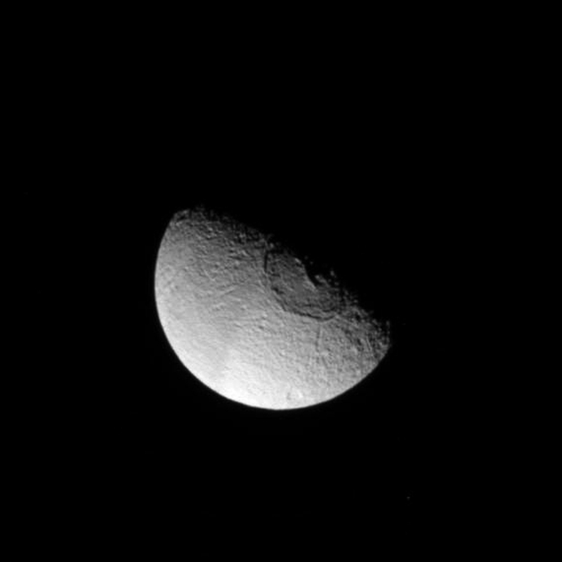
On June 28 NASA’s Cassini spacecraft passed by Tethys, a 1,062-kilometer (662-mile) -wide moon of Saturn that’s made almost entirely of ice. Tethys is covered in craters of all sizes but by far the most dramatic of all is the enormous Odysseus crater, which spans an impressive 450 kilometers (280 miles) of the moon’s northern hemisphere — nearly two-fifths of its entire diameter!
In fact, whatever struck Tethys in the distant past probably should have shattered it into pieces… but didn’t.
Tethys likely held itself together because when the impact occurred that formed Odysseus, the moon was still partially molten. It was able to absorb some of the energy of the impact and thus avoid disintegration — although it was left with a quite the battle scar as an eternal reminder.
The images below are raw images from Cassini’s latest pass of Tethys, showing the moon’s rugged terrain and portions of Odysseus from a distance of 68,521 kilometers (42,577 miles).
The central peak of Odysseus has collapsed, leaving a depression — another indication that the moon wasn’t entirely solid at the time of impact.
Tethys orbits Saturn at a distance of 294,660 kilometers (183,100 miles), about 62,000 miles closer than the Moon is from Earth. Such a close proximity to Saturn subjects Tethys to tidal forces, the frictional heating of which likely helped keep it from cooling and solidifying longer than more distant moons. As a result Tethys appears somewhat less cratered than sister moons Rhea and Dione, which still bear the marks of their earliest impacts… although looking at the region south of Odysseus it’s hard to image a more extensively-cratered place.
Tethys is just another reminder of the violent place our solar system can be. Find out more about Tethys on the Cassini mission site here.
Image credits: NASA/JPL/Space Science Institute. Edited by J. Major. Images have not been calibrated or validated, and each has been level-adjusted and sharpened to bring out surface detail, and in some areas deinterlacing was used to remove linear raw image artifacts.
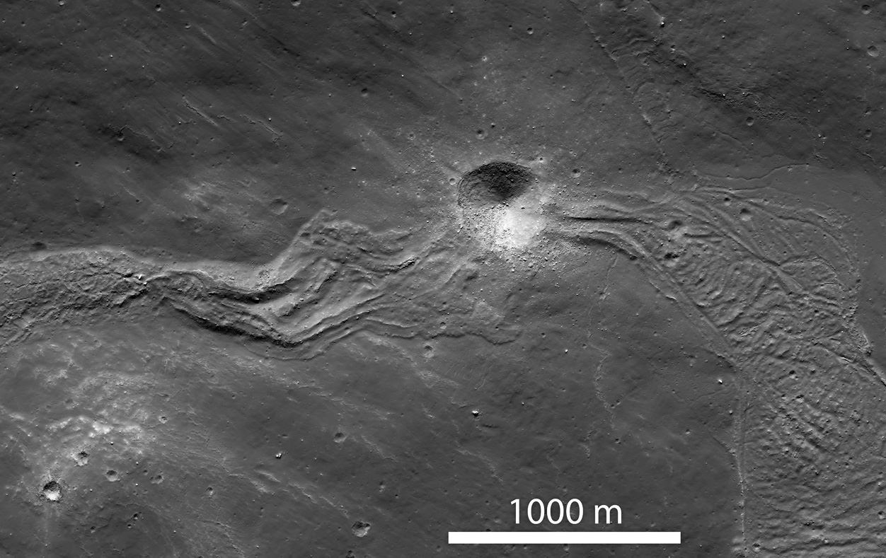
The Moon may not have ever had liquid water on its surface — despite the use of the term mare, Latin for “sea” and moniker for the large regions of darker material visible from Earth — but liquid did indeed flow on the Moon in ages past… liquid rock, briefly set loose by the impacts that formed its ubiquitous craters.
When large meteorites impacted the Moon, crust at the site would melt and get flung outwards, flowing downhill as rivers of rock and creating streams and pools of melted material before cooling and solidifying. There the rivers would remain, a permanently-hardened testament to the event that made them.
The image above, part of a NAC scan acquired by NASA’s Lunar Reconnaissance Orbiter on March 9, shows a solidified melt flow dating back to the creation of Tycho crater approximately 108 million years ago –which may sound like a long time but it’s actually very recent for large-scale lunar features.
The flow is interrupted by a younger, 400-meter-wide crater that impacted the lunar surface along its length. Since it punches through the melt flow as well as the local surface, it would be a great place for future astronaut geologists to explore!
Taken under slightly different lighting conditions, the image below shows a large melt pond that the flow above terminates in. The pond is about 4500 meters long by 2100 meters across (2.8 x 1.3 miles).
Such images wouldn’t be possible without the awesome Lunar Reconnaissance Orbiter. Launched on June 18, 2009, LRO explores the lunar surface from an altitude of only 50 km (31 miles). Read more on the LRO site here.
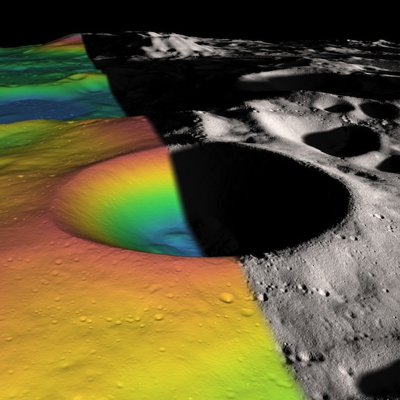
Shackleton crater on the Moon’s south pole has been somewhat of an enigma, as its permanently shadowed interior has made it difficult to detect what is inside. But with new observations using the laser altimeter on the Lunar Reconnaissance Orbiter (LRO) spacecraft, a team of researchers has essentially illuminated the crater’s interior with laser light, measuring its albedo, or natural reflectance. The scientists found that the crater’s floor is quite bright, an observation consistent with the presence of ice. In fact, ice may make up 22 percent of the material on the crater floor, with possibly more ice embedded within the crater walls.
“We decided we would study the living daylights out of this crater,” said Maria Zuber from the Massachuesetts Institute of Technology, who lead a team to study Shackleton Crater. “From the incredible density of observations we were able to make an extremely detailed topographic map.”
For laser altimeter observations, elevation maps can be created by measuring the time it takes for laser light to bounce down to the Moon’s surface and back to the instrument. The longer it takes, the lower the terrain’s elevation. Using these measurements, the group mapped the crater’s floor and the slope of its walls.
The team used over 5 million measurements to create their detailed map.
While the crater’s floor was relatively bright, Zuber and her colleagues observed that its walls were even brighter. The finding was at first puzzling. Scientists had thought that if ice were anywhere in a crater, it would be on the floor, where no direct sunlight penetrates. The upper walls of Shackleton crater are occasionally illuminated, which could evaporate any ice that accumulates. A theory offered by the team to explain the puzzle is that “moonquakes”– seismic shaking brought on by meteorite impacts or gravitational tides from Earth — may have caused Shackleton’s walls to slough off older, darker soil, revealing newer, brighter soil underneath. Zuber’s team’s ultra-high-resolution map provides strong evidence for ice on both the crater’s floor and walls.
“There may be multiple explanations for the observed brightness throughout the crater,” said Zuber. “For example, newer material may be exposed along its walls, while ice may be mixed in with its floor.”
The crater, named after the Antarctic explorer Ernest Shackleton, is nearly 20 km (more than 12 miles) wide and over 3 km (2 miles) deep — about as deep as Earth’s oceans. Zuber described the crater’s interior as “extremely rugged … It would not be easy to crawl around in there.”
She added that the new topographic map will help researchers understand crater formation and study other uncharted areas of the moon.
“I will never get over the thrill when I see a new terrain for the first time,” Zuber said. “It’s that sort of motivation that causes people to explore to begin with. Of course, we’re not risking our lives like the early explorers did, but there is a great personal investment in all of this for a lot of people.”
Ben Bussey, staff scientist at Johns Hopkins University’s Applied Physics Laboratory, said the new evidence for ice in Shackleton crater may indeed help determine the course for future lunar missions.
“Ice in the polar regions has been sort of an enigmatic thing for some time … I think this is another piece of evidence for the possibility of ice,” Bussey says. “To truly answer the question, we’ll have to send a lunar lander, and these results will help us select where to send a lander.”
And for any humans explorers, a crater like Shackleton at the lunar poles may well be the best location for a base, as the poles contain regions of near-permanent sunlight needed for power, and regions of near-permanent darkness containing ice — both of which would be essential resources for any lunar colony.
The team’s research was published today in the Journal Nature.
Lead image caption: Elevation (left) and shaded relief (right) image of Shackleton, a 21-km-diameter (12.5-mile-diameter) permanently shadowed crater adjacent to the lunar south pole. The structure of the crater’s interior was revealed by a digital elevation model constructed from over 5 million elevation measurements from the Lunar Orbiter Laser Altimeter. Credit: NASA/Zuber, M.T. et al., Nature, 2012
Second image caption: This is an elevation map of Shackleton crater made using LRO Lunar Orbiter Laser Altimeter data. The false colors indicate height, with blue lowest and red/white highest. Credit: NASA/Zuber, M.T. et al., Nature, 2012
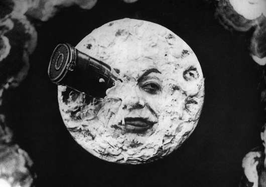
Should we pay another visit to the Moon? (From "Le Voyage Dans La Lune" by Georges Méliès, 1902)
Humans haven’t set foot on the Moon — or any other world outside of our own, for that matter — since Cernan and Schmitt departed the lunar surface on December 14, 1972. That will make 40 years on that date this coming December. And despite dreams of moon bases and lunar colonies, there hasn’t even been a controlled landing there since the Soviet Luna 24 sample return mission in 1976 (not including impacted probes.) So in light of the challenges and costs of such an endeavor, is there any real value in a return to the Moon?
Some scientists are saying yes.
Researchers from the UK, Germany and The Netherlands have submitted a paper to the journal Planetary and Space Science outlining the scientific importance of future lunar surface missions. Led by Ian A. Crawford from London’s Birkbeck College, the paper especially focuses on the value of the Moon in the study of our own planet and its formation, the development of the Earth-Moon system as well as other rocky worlds and even its potential contribution in life science and medicinal research.
Even though some research on the lunar surface may be able to be performed by robotic missions, Crawford et al. ultimately believe that “addressing them satisfactorily will require an end to the 40-year hiatus of lunar surface exploration.”
The team’s paper outlines many different areas of research that would benefit from future exploration, either manned or robotic. Surface composition, lunar volcanism, cratering history — and thus insight into a proposed period of “heavy bombardment” that seems to have affected the inner Solar System over 3.8 billion years ago — as well as the presence of water ice could be better investigated with manned missions, Crawford et al. suggest.
In addition, the “crashed remains of unsterilized spacecraft” on the Moon warrant study, proposes Crawford’s team. No, we’re not talking about alien spaceships — unless the aliens are us! The suggestion is that the various machinery we’ve sent to the lunar surface since the advent of the Space Age may harbor Earthly microbes that could be returned for study after decades in a lunar environment. Such research could shed new light on how life can — or can’t — survive in a space environment, as well as how long such “contaminants” might linger on another world.
Crawford’s team also argues that only manned missions could offer all-important research on the long-term effects of low-gravity environments on human physiology, as well as how to best sustain exploration crews in space. If we are to ever become a society with the ability to explore and exist beyond our own planet, such knowledge is critical.
And outside of lunar exploration itself, the Moon offers a place from which to perform deeper study of the Universe. The lunar farside, shielded as it is from radio transmissions and other interference from Earth, would be a great place for radio astronomy — especially in the low-frequency range of 10-30 MHz, which is absorbed by Earth’s ionosphere and is thus relatively unavailable to ground-based telescopes. A radio observatory on the lunar farside would have a stable platform from which to observe some of the earliest times of the Universe, between the Big Bang and the formation of the first stars.
Of course, before anything can be built on the Moon or retrieved from its surface, serious plans must be made for such missions. Fortunately, says Crawford’s team, the 2007 Global Exploration Strategy — a framework for exploration created by 13 space agencies from around the world — puts the Moon as the “nearest and first goal” for future missions, as well as Mars and asteroids. Yet with subsequent budget cuts for NASA (a key player for many exploration missions) when and how that goal will be reached still remains to be seen.
“…this long hiatus in lunar surface exploration has been to the detriment of lunar and planetary science, and indeed of other sciences also, and that the time has come to resume the robotic and human exploration of the surface of the Moon.”
— Ian A. Crawford, Department of Earth and Planetary Sciences, Birkbeck College, UK
Top image from “Le Voyage Dans La Lune” by Georges Méliès, 1902. Second image: First photo of the far side of the Moon, acquired by the Soviet Luna-3 spacecraft on Oct. 7, 1959.
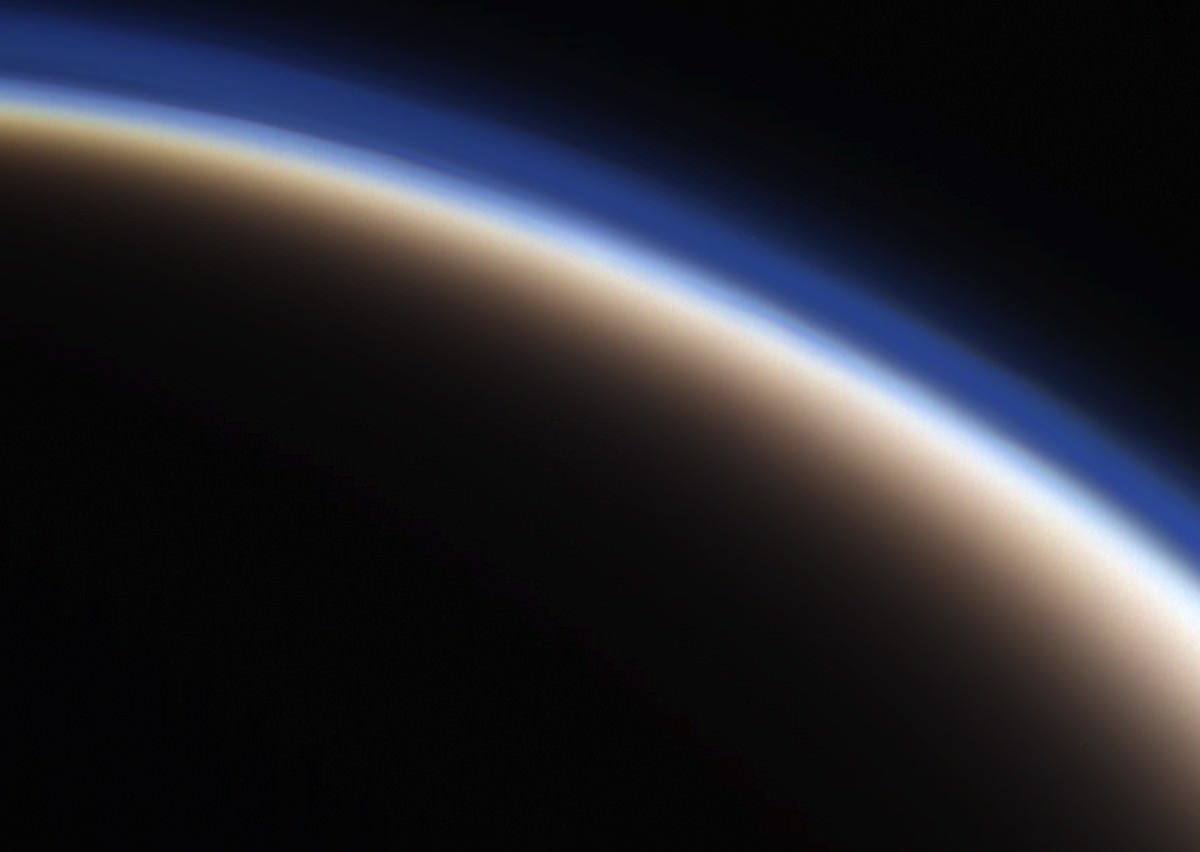
Titan's haze-covered limb seen by Cassini on June 6
[/caption]
Here’s a quick look at one of my favorite cosmic photo subjects – the varying layers of atmosphere that enshroud Saturn’s enormous moon Titan. The image above is a color-composite made from three raw images acquired by Cassini during its latest flyby.
On June 7 Cassini approached Titan within 596 miles (959 km) and imaged portions of the moon’s northwest quadrant with its radar instrument, as well as conducted further investigations of areas near the equator where surface changes were detected in 2010.
The image here was assembled from three raw images captured in red, green and blue visible light channels. It reveals some structure in the upper hydrocarbon haze layers that extend upwards above the moon’s opaque orange clouds — reaching 400-500 km in altitude, Titan’s atmosphere is ten times thicker than Earth’s!
The June 6 flyby was the second in a series of passes that will take Cassini into a more inclined orbit, where it will reside for the next three years as it investigates Saturn’s polar regions and obtains better views of its ring system.
Astronaut Don Pettit continues to ‘wow’ us all with his photographic exploits. In this great timelapse video, not only does Pettit capture a stunning Moonrise over Earth, but he had the presence of mind to set up his video camera in such way that he could also show himself opening the shutters in the space station’s Cupola observation windows just in time to watch all the action. The time-lapse scene was photographed from the airlock of the ISS’s Russian segment.
his is a view of the moon transiting, or passing in front of, the Sun as seen from the STEREO-B spacecraft on Feb. 25, 2007. The Sun is in false color, and the moon appears as a black disk on the upper right. NASA's STEREO mission consists of two spacecraft launched in October, 2006 to study solar storms. Credit: NASA
With the Moon as the most prominent object in the night sky and a major source of an invisible pull that creates ocean tides, many ancient cultures thought it could also affect our health or state of mind – the word “lunacy” has its origin in this belief. Now, a powerful combination of spacecraft and computer simulations is revealing that the moon does indeed have a far-reaching, invisible influence – not on us, but on the Sun, or more specifically, the solar wind.
The solar wind is a thin stream of electrically conducting gas called plasma that’s constantly blown off the surface of the Sun in all directions at around a million miles per hour. When a particularly fast, dense or turbulent solar wind strikes Earth’s magnetic field, it can generate magnetic and radiation storms that are capable of disrupting satellites, power grids, and communication systems. The magnetic “bubble” surrounding Earth also pushes back on the solar wind, creating a bow shock tens of thousands of miles across over the day side of Earth where the solar wind slams into the magnetic field and abruptly slows from supersonic to subsonic speed.
Unlike Earth, the Moon is not surrounded by a global magnetic field. “It was thought that the solar wind crashes into the lunar surface without any warning or ‘push back’ on the solar wind,” says Dr. Andrew Poppe of the University of California, Berkeley. Recently, however, an international fleet of lunar-orbiting spacecraft has detected signs of the Moon’s presence “upstream” in the solar wind. “We’ve seen electron beams and ion fountains over the Moon’s day side,” says Dr. Jasper Halekas, also of the University of California, Berkeley.
These phenomena have been seen as far as 10,000 kilometers (6,214 miles) above the Moon and generate a kind of turbulence in the solar wind ahead of the Moon, causing subtle changes in the solar wind’s direction and density. The electron beams were first seen by NASA’s Lunar Prospector mission, while the Japanese Kaguya mission, the Chinese Chang’e mission, and the Indian Chandrayaan mission all saw ion plumes at low altitudes. NASA’s ARTEMIS mission has now also seen both the electron beams and the ion plumes, plus newly identified electromagnetic and electrostatic waves in the plasma ahead of the Moon, at much greater distances from the moon. “With ARTEMIS, we can see the plasma ring and wiggle a bit, surprisingly far away from the Moon,” says Halekas. ARTEMIS stands for “Acceleration, Reconnection, Turbulence and Electrodynamics of the Moon’s Interaction with the Sun”.
This is an artist's concept of the Earth's global magnetic field, with the bow shock. Earth is in the middle of the image, surrounded by its magnetic field, represented by purple lines. The bow shock is the blue crescent on the right. Many energetic particles in the solar wind, represented in gold, are deflected by Earth's magnetic "shield". Credit: Walt Feimer (HTSI)/NASA/Goddard Space Flight Center Conceptual Image Lab
“An upstream turbulent region called the ‘foreshock’ has long been known to exist ahead of the Earth’s bow shock, but the discovery of a similar turbulent layer at the moon is a surprise,” said Dr. William Farrell of NASA’s Goddard Space Flight Center in Greenbelt, Md. Farrell is lead of the NASA Lunar Science Institute’s Dynamic Response of the Environment At the Moon (DREAM) lunar science center, which contributed to the research.
Computer simulations help explain these observations by showing that a complex electric field near the lunar surface is generated by sunlight and the flow of the solar wind. The simulation reveals this electric field can generate electron beams by accelerating electrons blasted from surface material by solar ultraviolet light. Also, related simulations show that when ions in the solar wind collide with ancient, “fossil” magnetic fields in certain areas on the lunar surface, they are reflected back into space in a diffuse, fountain-shaped pattern. These ions are mostly the positively charged ions (protons) of hydrogen atoms, the most common element in the solar wind.
“It’s remarkable that electric and magnetic fields within just a few meters (yards) of the lunar surface can cause the turbulence we see thousands of kilometers away,” says Poppe. When exposed to solar winds, other moons and asteroids in the solar system should have this turbulent layer over their day sides as well, according to the team.
“Discovering more about this layer will enhance our understanding of the Moon and potentially other bodies because it allows information about conditions very near the surface to propagate to great distances, so a spacecraft will gain the ability to virtually explore close to these objects when it’s actually far away,” said Halekas.
The research is described in a series of six papers recently published by Poppe, Halekas, and their colleagues at NASA Goddard, U.C. Berkeley, U.C. Los Angeles, and the University of Colorado at Boulder in Geophysical Research Letters and the Journal of Geophysical Research. The research was funded by NASA’s Lunar Science Institute, which is managed at NASA’s Ames Research Center, Moffett Field, Calif., and oversees the DREAM lunar science center.
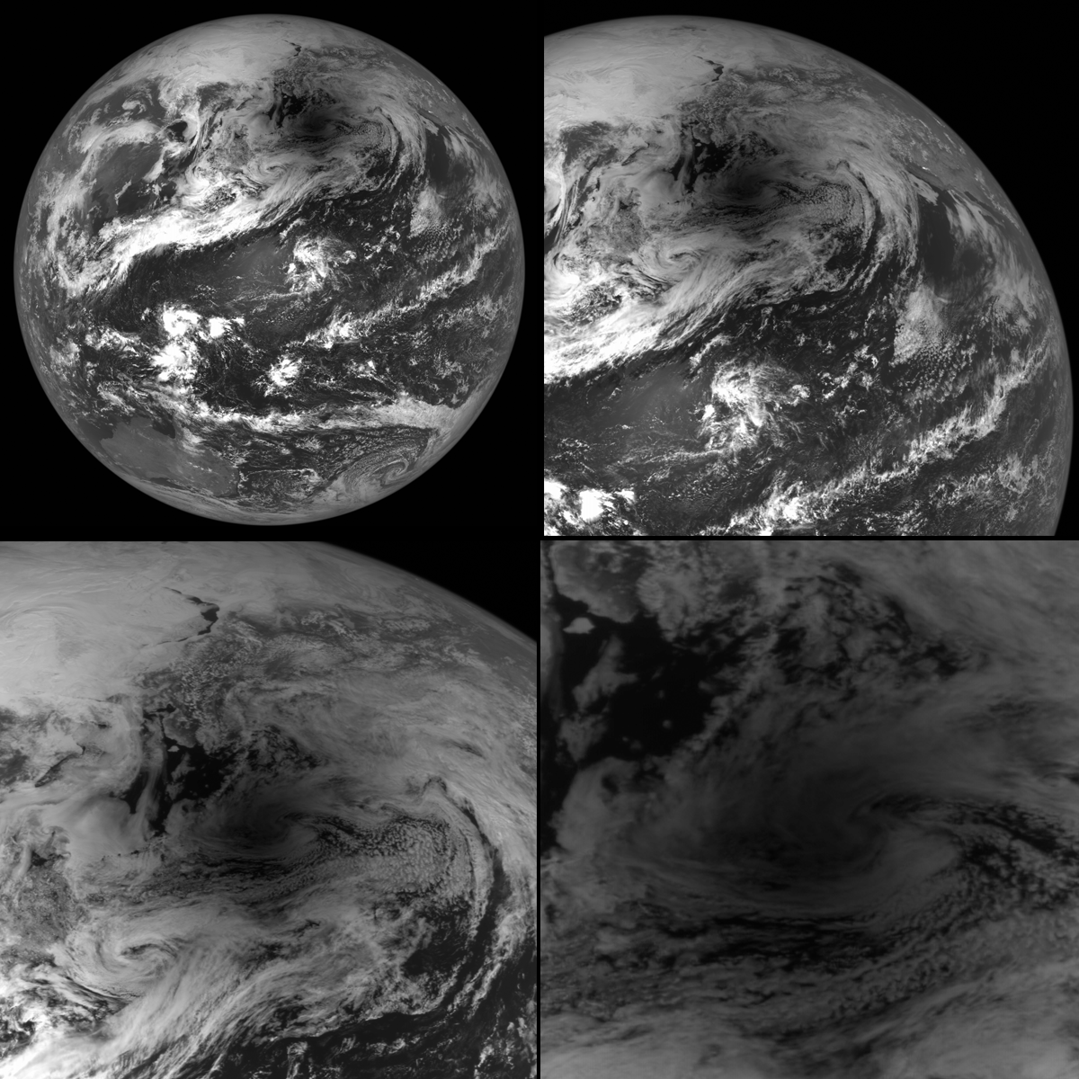
The LROC turns to capture the Moon's shadow during the May 20 solar eclipse [NASA/GSFC/Arizona State University].
[/caption]
The May 20 annular eclipse may have been an awesome sight for skywatchers across many parts of the Earth, but it was also being viewed by a robotic explorer around the Moon!
During the event NASA’s Lunar Reconnaissance Orbiter turned its camera to look back home, acquiring several images of the Earth with the Moon’s fuzzy shadow cast onto different regions during the course of the eclipse. The image above is a 4-panel zoom into one particular NAC image showing the Moon’s shadow over the Aleutian Islands.
LRO captured a total of four narrow-angle camera (NAC) images during two of its orbits. During one orbit the Moon’s shadow was over the southern part of Japan, and during the next it had moved northeast to cover the island chain of Alaska.
According to the LROC site run by Arizona State University:
The NAC is a line scanner, meaning that it has only one row of 5064 pixels per camera. Instead of snapping a single frame, an image is built up by the motion of the spacecraft in orbit about the Moon (about 1600 meters per second). To obtain an image of the Earth the spacecraft is turned 180° to face the Earth, then the spacecraft is pitched as quickly as possible (one-tenth of a degree per second), so that the image is built up line by line.
This also explains why some of the images are “clipped” on the edges… LRO ran out of time during its lunar orbit. Still, it’s great to be able to show some photos of the eclipse from quite possibly the most distant viewer anywhere!
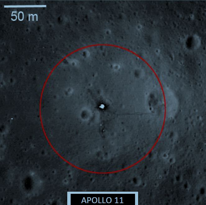
NASA recommends an artifact boundary extending 75 m from the Apollo 11 lunar module descent stage. Photo credit: NASA
[/caption]
Don’t say you haven’t been warned. NASA put out an official document today specifying how close any future spacecraft and astronauts visiting the Moon can come to the artifacts left on the lunar surface by all US space missions, including the Apollo landing sites, any robotic landing sites like Surveyor and impact sites like LCROSS.
While these recommendations are not mandatory (there’s obviously no way to enforce this yet) the document states, “rather, it is offered to inform lunar spacecraft mission planners interested in helping preserve and protect lunar historic artifacts and potential science opportunities for future missions.”
For example, NASA recommends an artifact boundary extending 75 m from the Apollo 11 lunar module descent stage.
NASA isn’t expecting a rush of astro-looters to descend upon the Moon, but with China discussing a Moon landing, and with several Google Lunar X PRIZE teams hoping to send robotic landers, they want to make sure nothing from previous missions is disturbed.
“In the 50 years since the first lunar missions, the spaceflight community has not formally provided recommendations to the next generation of lunar explorers on how to preserve the original artifacts and protect ongoing science from the potentially damaging effects of nearby landers,” NASA said in an accompanying press release, saying that they recognize the steadily increasing technical capabilities of space-faring commercial entities and nations throughout the world that may be on the verge of landing spacecraft on the surface of the Moon.
The document specifies how close another spacecraft can hover, flyover, hop or touchdown near landing sites or spacecraft.
And not just hardware is included in the “don’t touch” areas: “U.S. human, human-robotic lunar presence, including footprints, rover tracks, etc., although not all anthropogenic indicators are protected as identified in the recommendations,” the document says.
NASA’s decisions on proximity boundaries were made from recommendations from external experts from the historic, scientific and flight-planning communities and apply to US government artifacts on the lunar surface.
NASA says they released this document to open discussions with commercial and international space agencies, and seek any improvements to the recommendations.
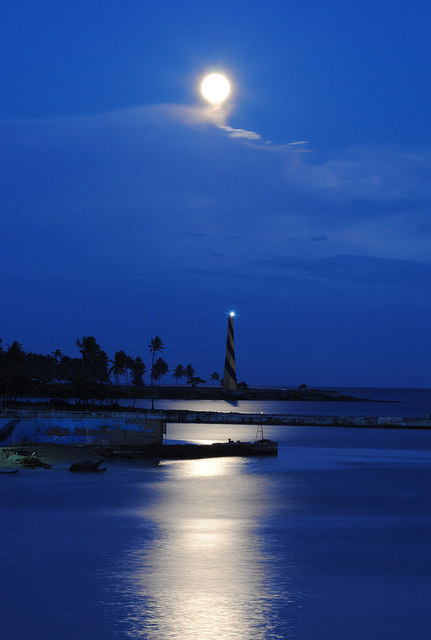
San Souci lighthouse and the perigee Moon, in the Dominican Republic. Credit: Goku Abreu.
[/caption]
We asked for ’em, and you sent ’em in: here are great images of the perigee Moon on May 5, 2012, the largest full Moon of the year taken by our readers.
The perigee Moon as seen in Opelika, Alabama USA. Credit: Jacob Marchio. The Supermoon on a finger, as seen in Aguilas, Murcia Spain. Credit: Tapani IsomäkiAn artist's view of the 'Supermoon.' Credit: Omer Sidat.Largest Full Moon for 2012 from Dayton, Ohio USA. Credit: John Chumack.Perigee Moon on May 5, 2012 from Altamonte Springs, Florida USA. Credit: Austin Russie.A shy supermoon from Brick Landing, North Carolina USA. Credit: Tavi Greiner.The supermoon from Juiz de Fora, Minas Gerais, Brazil. Credit: jimctu on FlickrPreparing for a Supermoon, on May 3, 2012 from Wauseon, Ohio. Credit: Bill Schlosser.A lovely Moonrise at Soldier's Beach off the Central Coast of New South Wales, Australia. Credit: Kerry Middlemiss'Taken from the Marin Headlands with about 573 other photographer friends. I used my Orion ED Refractor telescope for a lens,' said photographer Ted Judah. Supermoon over the Pacific, taken at Goblets Beach in Santa Barbara, California, USA. Credit: Jonathan Vail. Full Super Moon rising over UC Berkeley Sather Tower Campanile and International House. Credit: Ira Serkes.Super full Moon over Tucson, Arizona, USA. Credit: 'Sifted Reality' on Flickr.Digiscope of the 2012 Supermoon, São Paulo, Brazil. Credit: Monica, 'MoniBR' on Flickr. The perigee full Moon from Cocoa Beach, Florida, USA. Credit: Jamie Rich.The perigee Moon from Toronto, Canada. Credit: Rick Ellis. The Moon on May 6, 2012 in Mandan, North Dakota, USA. Credit: Jola Boehm
And speaking of images from ‘around the world,’ here’s one from the International Space Station:
The perigee full Moon on May 5, 2012, as seen through Earth’s atmosphere, which bends the light from the Moon, making it appear squished. Credit: Andre Kuipers/ESA/NASA
Thanks to everyone who sent in their images and posted them to our Flickr page. See more images and find more from our contributors at Universe Today’s Flickr page.