A mock-up of a future Chinese Martian rover was displayed at the International Industry Fair in Shanghai (Credit: South China Morning Post)
For many space-faring nations, ambitions for Mars run broad and deep. Now, add China to the list of countries with Mars in their sights. News reports from China disclosed that country is considering a future Mars rover mission, with a potential 2020 launch date. Additionally came other hints that China may be looking to develop a next-generation heavy-lift launch system.
This new project, while early in development, reveals how Chinese aspirations are growing rapidly. Human space flight successes have been followed by recent lunar mission successes of the Yutu lunar rover and the Chang’e-5 T1 test of a sample return mission. The Chinese Mars missions could influence future plans of ESA, India and NASA or more simply raise the urgency to execute missions in concept or early development without hesitation.
China View reporter Lai Yuchen is seen describing and pointing out the future Sino-Mars rover with plans for a 2020 launch coinciding with the NASA/JPL Mars 2020 rover mission . (Click still image for video Link) (Photo/Video Credit: China View)
The Mars rover mock-up display was presented at the aerospace show by China Aerospace Science and Technology Corporation (CASC). The design appears similar to the Yutu rover which landed successfully on the Moon late in 2013. While Yutu’s mobility system failed prematurely, many mission milestones were achieved.
The Mars rover design is significantly larger than Yutu but includes changes that can be attributed to the challenges of roving Mars at tens of millions of kilometers distance and under more gravitational force. The wheels are beefed up, since it must withstand more force and rugged martian terrain (gravity on Mars is 37% of the Earth’s in strength but 2.25 times the strength of gravity on the Moon’s surface.) The the solar panels are larger due to 1.) less sunlight at Mars – 35% to 50% of Earth’s, and 2.) more electrically demanding instruments.
The goals of the Chinese Mars rover will be to search for life and water. The NASA missions searching for indicators of habitable environments and for water has cost billions of dollars but the Chinese space program is operating on a fraction of what NASA’s annual budget is. Whereas the Chinese Mars program will be competing with the lunar program for government funds, it remains to be seen how quickly they can make progress and actually meet milestones for a 2020 launch date.
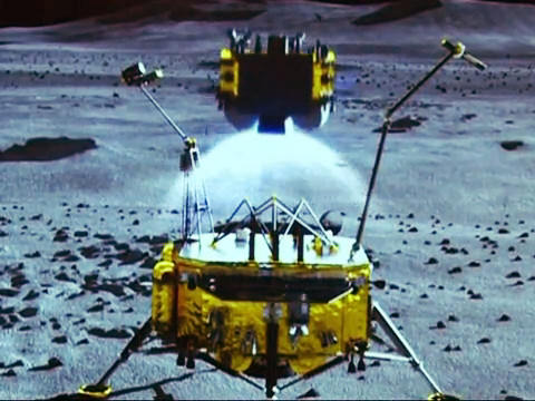
Besides video of the China View reporter presenting and discussing the Mars rover (link to photo above), the video also includes a simulation of the Chinese lunar sample return spacecraft, which is underdevelopment and was tested early this month during a the Chang’e-5 T1 circum-lunar mission that proved a small re-entry vehicle.
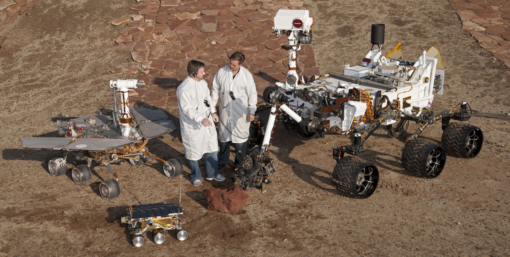
The future Chinese rover would be nearly as large as the MER rovers. Full scale models of all three NASA/JPL Mars rovers are shown here – Mars Pathfinder, MER and MSL in a JPL Mars yard with engineers. (Photo Credit: NASA/JPL)
The actual dimensions of this rover were not reported but an estimate of the size can be determined by the size of the high-gain directional antenna. Assuming it is an X-Band dish, like the one on the MER Rovers and Curiosity, then this Sino-rover would be near the same size as the MER rovers – Spirit and Opportunity. The Sino-rover shares a six wheel design like MER and MSL rovers.
Other reports from the China Daily indicated that industry leaders in China are urging China’s space agency to develop a more powerful heavy-lift launch system. It could be used for the nation’s human spaceflight goals to send a space station in to orbit, as well as send missions to Mars and beyond.
“It is a must for us to develop a more powerful heavy-lift rocket if we want to reach and explore deep space,” Zhang Zhi, a senior rocket researcher at the China Academy of Launch Vehicle Technology the aerospace exhibition.
Plans also call for an orbiter to likely function as a communication relay as MGS, Mars Odyssey and MRO have done for the American rovers. Whether this would involve a single spacecraft such as the NASA Vikings or dual crafts such as the present American rovers with supporting orbiters is unknown. Given the successful landing of the Yutu rover encapsuled in a soft-lander, one might expect the same for the Chinese Mars rover rather than an airbag landing used by MER. Either way, they will be challenged by the seven minutes of terror just like the American rovers. They will have to solve for themselves the entry, descent and landing of a rover. Only American-made rovers have successfully landed on Mars; all Russian attempts have ended in failure.
The Chinese Lunar Sample Return mission is show in simulation in the China View video. This mission would pave the way for a Chinese Mars sample return by 2030. (Photo Credit: China View)
The presentation also stated future plans for a sample-return mission by 2030. If the first Chineses Mars rover lands successfully in 2020, it will join up to four active rovers on the surface. Curiosity, ExoMars (ESA/NASA), Mars Rover 2020 and MER Opportunity. Six years seems like a long time but MER’s Oppy is a proven trooper having lasted over ten years. Curiosity, barring the unexpected, might last beyond 2020. ExoMars and NASA’s 2020 rover are still in development phases. Using ExoMars or 2020, NASA has plans to recover collected samples from rovers and return them to Earth in the 2020s and possibly as soon as 2022.
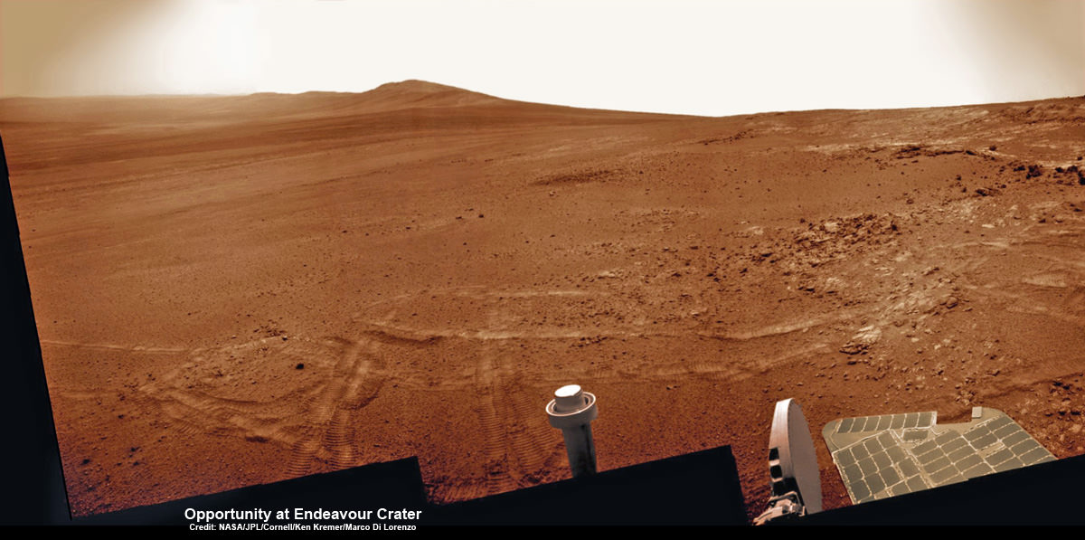
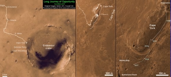
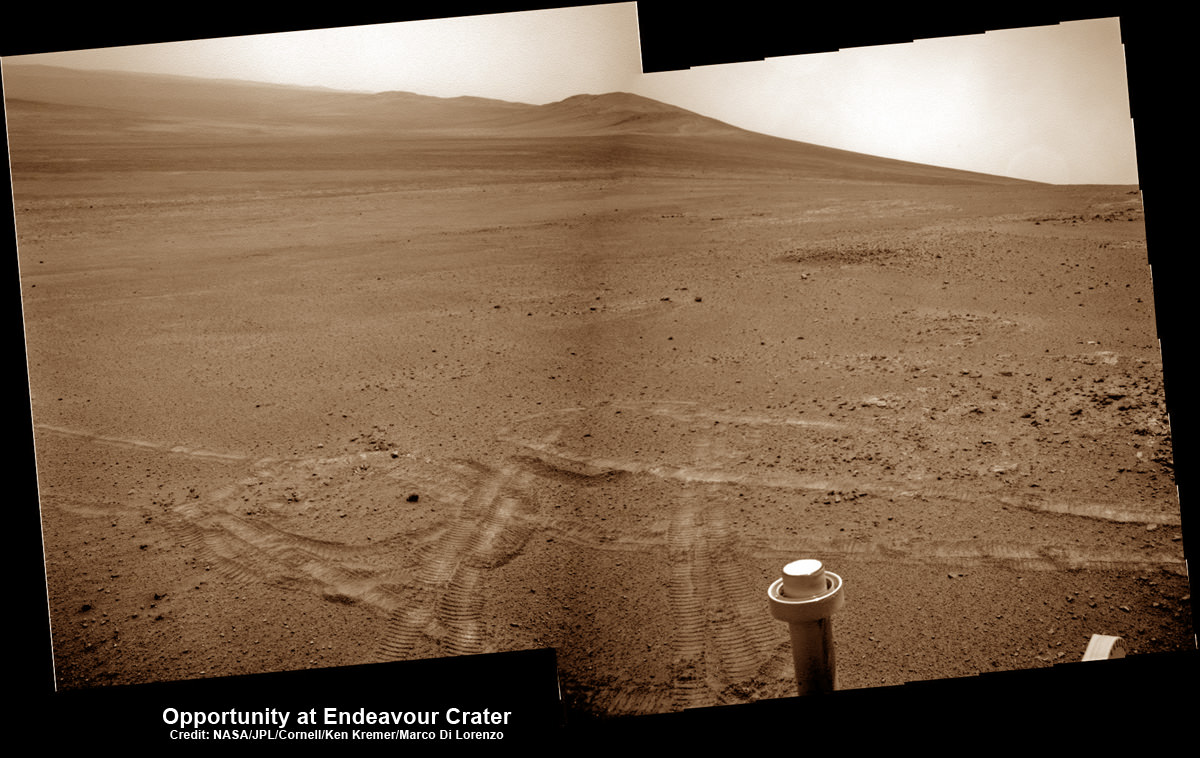
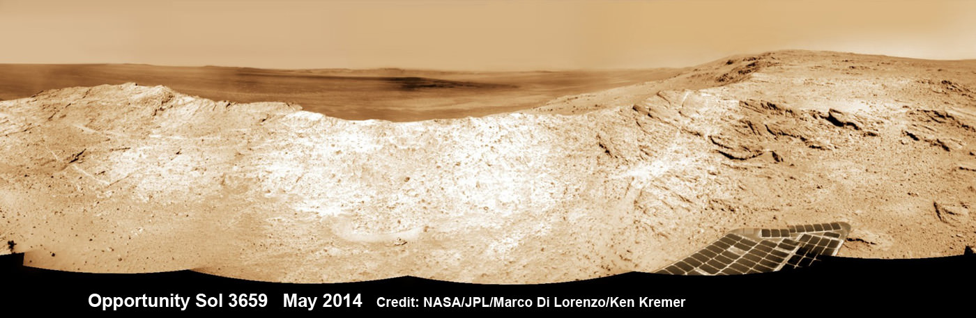
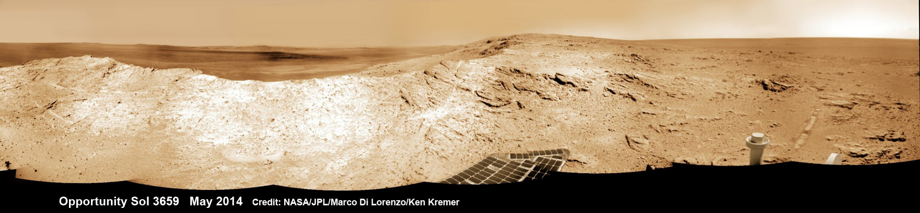
NASA’s Opportunity Mars rover captures sweeping panoramic vista near the ridgeline of 22 km (14 mi) wide Endeavour Crater’s western rim. The center is southeastward and also clearly shows the distant rim. See the complete panorama below. This navcam panorama was stitched from images taken on May 10, 2014 (Sol 3659) and colorized. Credit: NASA/JPL/Cornell/Marco Di Lorenzo/Ken Kremer-kenkremer.com
NASA’s Opportunity Mars rover captures sweeping panoramic vista near the ridgeline of 22 km (14 mi) wide Endeavour Crater’s western rim. The center is southeastward and also clearly shows the distant rim. See the complete panorama below. This navcam panorama was stitched from images taken on May 10, 2014 (Sol 3659) and colorized. Credit: NASA/JPL/Cornell/Marco Di Lorenzo/Ken Kremer-kenkremer.com
More mosaics and 10 year route map below[/caption]
NASA’s incredibly long lived Opportunity rover has driven to the ridgeline of a Martian mountain and captured spectacular panoramic vistas peering down into the vast expanse of huge Endeavour crater and out along the jagged rim segments leading to her next target – which scientists believe holds minerals indicative of a habitable zone. See mosaic views above and below.
Since departing the world famous ‘Jelly Doughnut’ rock by the summit of ‘Solander Point’ in February, Opportunity has spent the past several months driving south and exploring intriguing rock outcrops on ‘Murray Ridge’ located along the eroded western rim of Endeavour Crater.
The renowned robot is now exploring a region of outcrops atop the rims ridge that’s a possible site harboring deposits of hydrated clay minerals, formed in the ancient past when Mars was warmer and wetter.
The ten year oldRed Planet rover first reached the rim of Endeavour Crater in August 2011. She has captured numerous sweeping gorgeous vistas during her first of its kind expedition on the surface of another planet by an alien probe from Earth.
Read my earlier story detailing the top 10 discoveries from twin sisters Spirit and Opportunity according to Deputy Principal Investigator Prof. Ray Arvidson – here.
The gigantic crater spans 14 miles (22 kilometers) in diameter.
So there is endless enthralling terrain to investigate – for at least another 10 years!
The floor of Endeavour crater is filled with dark sand, brighter dust, and, in the distance, dusty haze, says NASA.
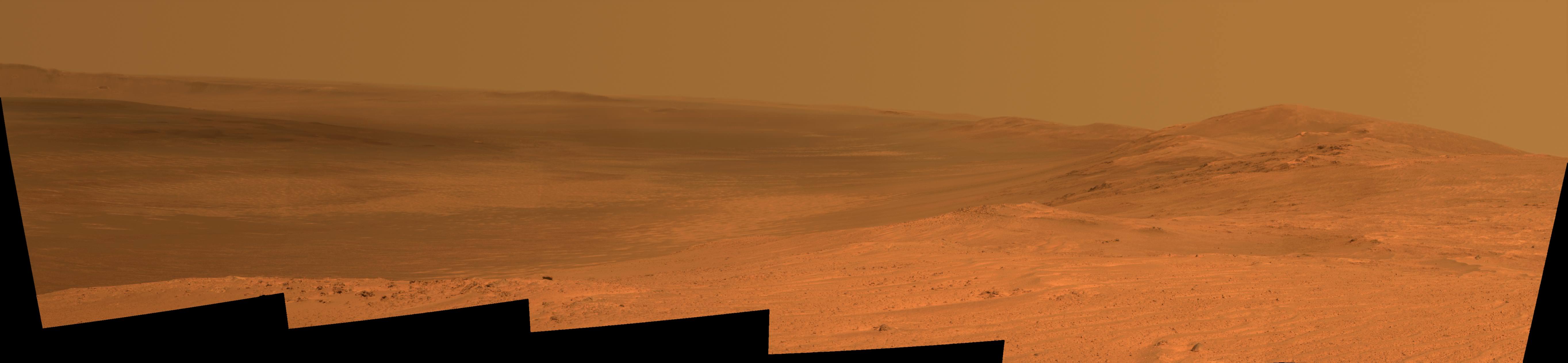
This vista of the Endeavour Crater rim was acquired by NASA’s Mars Exploration Rover Opportunity’s panoramic camera on April 18, 2014, from the southern end of “Murray Ridge” on the western rim of the crater. In mid-May, the rover approached the dark outcrops on the flank of the hill at right. The high peak in the distance on the right is informally named “Cape Tribulation” and is about 1.2 miles (2 kilometers) to the south of Opportunity’s position when this view was recorded Credit: NASA/JPL-Caltech/Cornell Univ./Arizona State Univ.
Opportunity’s goal all the while has been to doggedly trek southwards towards exposures of aluminum-rich clays detected from orbit by NASA’s powerful Martian ‘Spysat’ – the Mars Reconnaissance Orbiter (MRO) – while gathering context data at rock outcrops at Murray Ridge along the winding way.
These aluminum-rich clay minerals, or phyllosilicates, likely formed billions of years ago in flowing liquid neutral water which is more conducive to life, compared to more acidic environments explored earlier in the mission, and is therefore potentially indicative of a Martian habitable zone and a scientific goldmine.
The science and engineering team has used the high resolution MRO spectral and imaging data to more efficiently direct Opportunity southwards along the Endeavour crater rim and towards the biggest caches of the clay minerals – which were detected at a mountainous rim segment called ‘Cape Tribulation’ and which is seen in the panoramic vistas.
Although Cape Tribulation still lies some 1.2 miles (2 kilometers) further south, the rover has just arrived at a region which the team believes shows the first signatures of the clay minerals.
NASA’s Opportunity Mars rover captures sweeping panoramic vista near the ridgeline of 22 km (14 mi) wide Endeavour Crater’s western rim. The center is southeastward and the distant rim is visible in the center. An outcrop area targeted for the rover to study is at right of ridge. This navcam panorama was stitched from images taken on May 10, 2014 (Sol 3659) and colorized. Credit: NASA/JPL/Cornell/Marco Di Lorenzo/Ken Kremer-kenkremer.com
“The rover is exploring the region of aluminum-hydroxyl clay minerals seen from orbit,” said NASA in a mission update.
The six wheeled robot will utilize her mast mounted cameras and arm mounted microscopic imager (MI) and APXS spectrometer to gather images and measurements to unlock the mysteries of Mars ability to support life – past or present.
“The more we explore Mars, the more interesting it becomes. These latest findings present yet another kind of gift that just happens to coincide with Opportunity’s 10th anniversary on Mars,” said Michael Meyer, lead scientist for NASA’s Mars Exploration Program.
“We’re finding more places where Mars reveals a warmer and wetter planet in its history. This gives us greater incentive to continue seeking evidence of past life on Mars.”
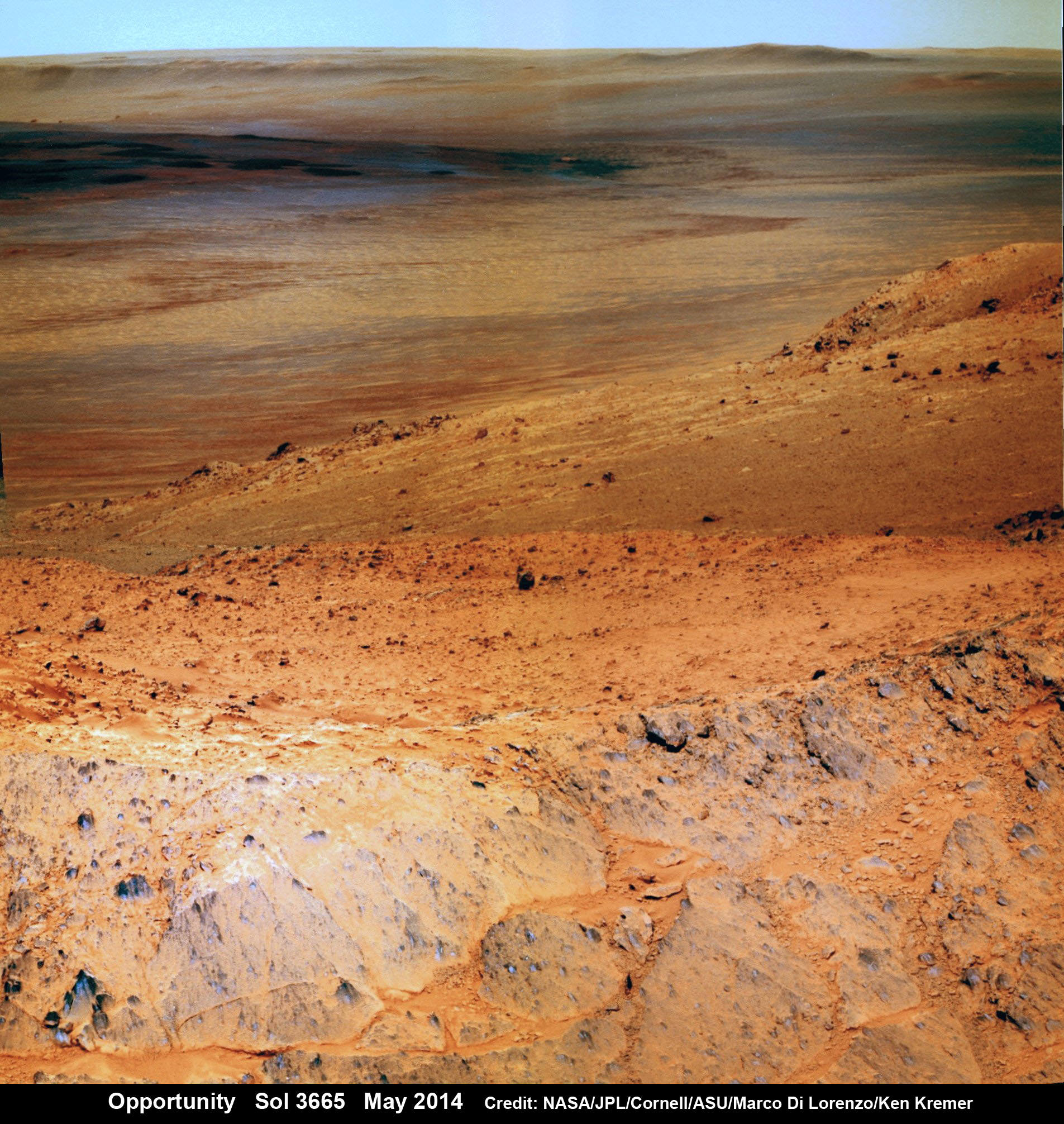
Opportunity Mars rover peers over mountain ridge for gorgeous vista into floor and out to distant rim of 22 km (14 mi) wide Endeavour Crater. This pancam camera view was assembled from images taken on May 16, 2014 (Sol 3665) with false color sky. Credit: NASA/JPL/Cornell/Marco Di Lorenzo/Ken Kremer-kenkremer.com
And Opportunity is now power-rich following a series of fortuitous wind cleaning events that substantially cleared the dust off the power generating solar wing arrays.
The solar array energy production has reached 761 watt-hours compared to about 900 watt-hours at landing in 2004 and only about 270 watt-hours just before Christmastime in December 2013.
“Solar panels [are] cleanest since about sol 1600 [September 2008],” says mission science team member Larry Crumpler.
More power means more work time and more bonus science studies and data return.
So the robot survived magnificently through her 6th harsh Martian winter with plenty of science rich targets planned ahead during the southern hemisphere Martian spring and summer.
Opportunity by Solander Point peak – 2nd Mars Decade Starts here!
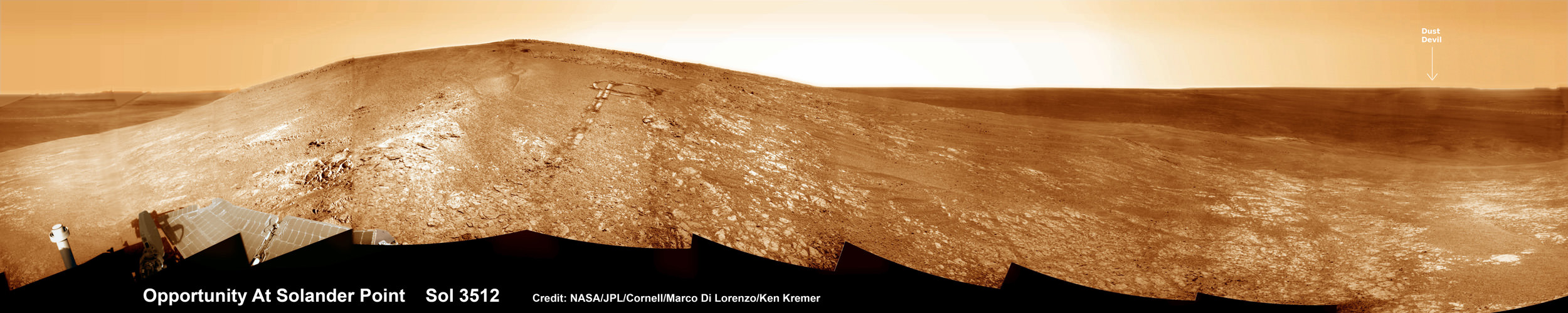
NASA’s Opportunity rover captured this panoramic mosaic on Dec. 10, 2013 (Sol 3512) near the summit of “Solander Point” on the western rim of Endeavour Crater where she starts Decade 2 on the Red Planet. She is currently investigating outcrops of potential clay minerals formed in liquid water on her 1st mountain climbing adventure. Assembled from Sol 3512 navcam raw images. Credit: NASA/JPL/Cornell/Marco Di Lorenzo/Ken Kremer-kenkremer.com
Today, May 24, marks Opportunity’s 3673nd Sol or Martian Day roving Mars – compared to a warranty of just 90 Sols.
So far she has snapped over 192,600 amazing images on the first overland expedition across the Red Planet.
Her total odometry stands at over 24.49 miles (39.41 kilometers) since touchdown on Jan. 24, 2004 at Meridiani Planum.
Meanwhile on the opposite side of Mars, Opportunity’s younger sister rover Curiosity is trekking towards gigantic Mount Sharp and just drilled into her 3rd Red Planet rock at Kimberley.
Stay tuned here for Ken’s continuing Curiosity, Opportunity, Orion, SpaceX, Boeing, Orbital Sciences, MAVEN, MOM, Mars and more planetary and human spaceflight news.
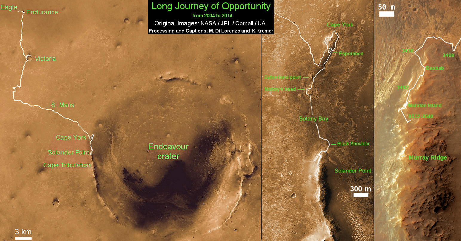
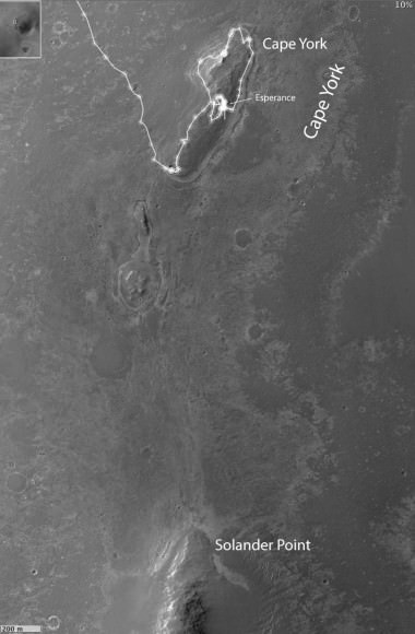
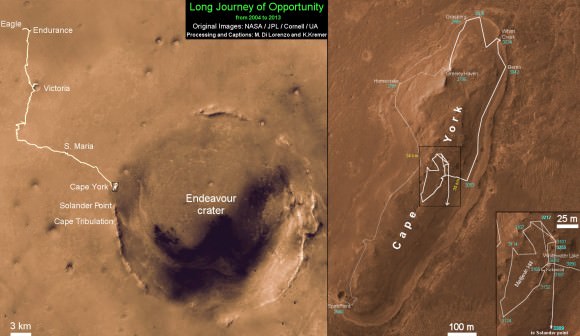
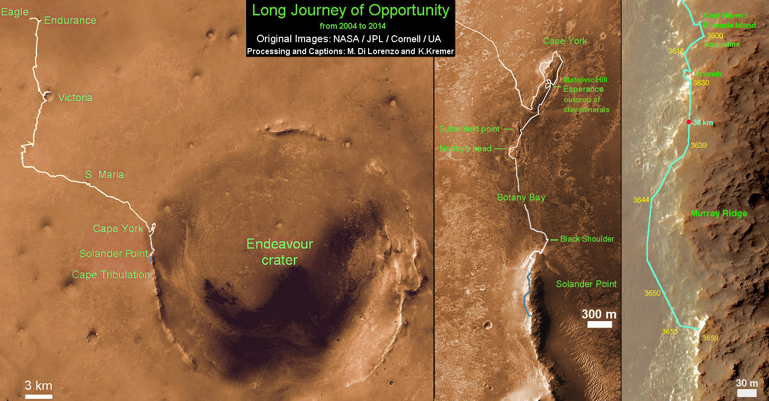
Traverse Map for NASA’s Opportunity rover from 2004 to 2014 – A Decade on Mars
This map shows the entire path the rover has driven during a decade on Mars and over 3660 Sols, or Martian days, since landing inside Eagle Crater on Jan 24, 2004 to current location along Murray Ridge south of Solander Point summit at the western rim of Endeavour Crater and heading to clay minerals at Cape Tribulation. Opportunity discovered clay minerals at Esperance – indicative of a habitable zone. Credit: NASA/JPL/Cornell/ASU/Marco Di Lorenzo/Ken Kremer
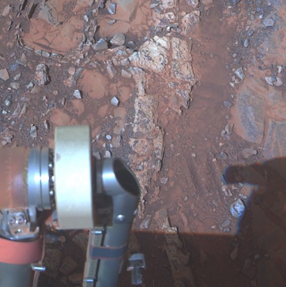
A nearly dust-free solar panel for the Opportunity rover following a dust cleaning wind event sometime during the last week of March 2014 (on Earth). Credit: NASA/JPL-Caltech/Cornell Univ./Arizona State University.
The Opportunity rover on Mars has gotten a 70% boost in power over the past few weeks. A good portion of that comes from the fact that its springtime in Mars’ southern hemisphere where Oppy now sits along the western rim of Endeavour Crater and so the Sun is now shining longer and higher in the sky. But also, several recent gusts of wind – or perhaps small dust devils – have cleaned much of the dust off the rover’s solar panels.
The rover team reported that between Sols 3605 and 3606 (March 15 and March 16, 2014), there was a dust cleaning event that resulted in about a 10% improvement in power production to 574 watt-hours, and then another cleaning event this week has put the power output to 615 watt-hours.
See a self-portrait that Opportunity took of its solar panels back in January to compare with the image above of how much cleaner the solar panels are now.
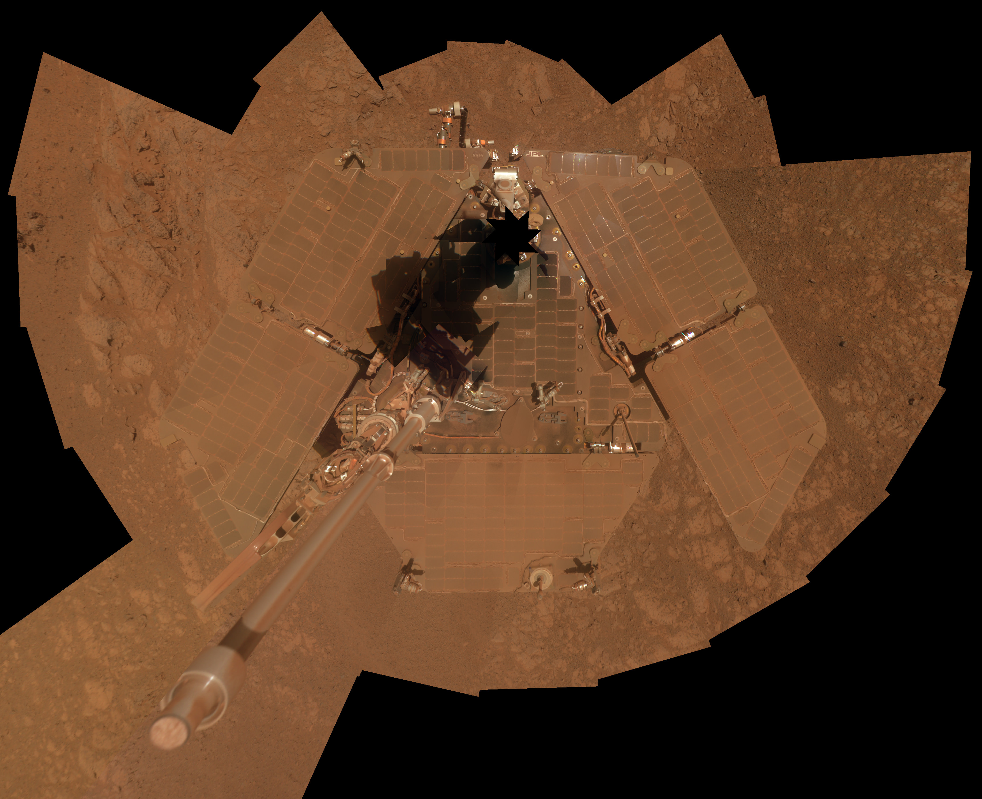
To celebrate 10 years of the Opportunity rover on Mars, the rover team used the panoramic camera (Pancam) to take images of the rover itself during the interval Jan. 3, 2014, to Jan. 6, 2014. Credit: NASA/JPL-Caltech/Cornell Univ./Arizona State Univ.
Of course, this is not the first time a wind cleaning event has dusted off the solar panels — in fact it has happened several times (see here, here, and here) which is one of the reasons for the longevity of the solar-powered rovers.
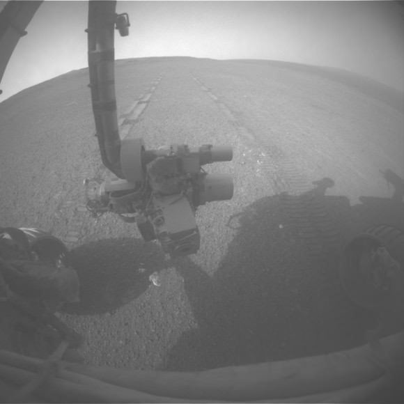
I love these self-images the rovers can take, and below is a great recent image the rover took of its own shadow, in the late-afternoon Sun. The image was taken by the rover’s rear hazard avoidance camera.
Late afternoon lighting produced a dramatic shadow of NASA’s Mars Exploration Rover Opportunity photographed by the rover’s rear hazard-avoidance camera on March 20, 2014. Credit: NASA/JPL-Caltech/Cornell Univ./Arizona State Univ.
The image was taken looking eastward shortly before sunset on Sol 3,609 (March 20, 2014). The rover’s shadow falls across a slope called the McClure-Beverlin Escarpment on the western rim of Endeavour Crater, where Opportunity is investigating rock layers for evidence about ancient environments. The scene includes a glimpse into the distance across the 14-mile-wide (22-kilometer-wide) crater.
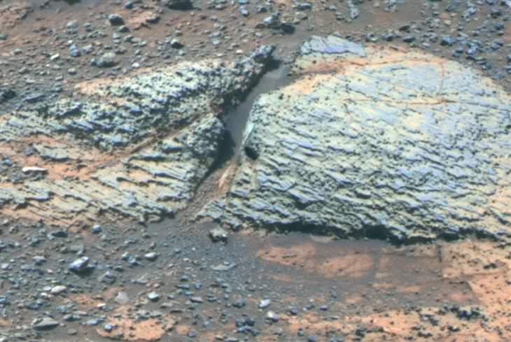
Carbonate-Containing Martian Rocks discovered by Spirit Mars Rover. Spirit collected data in late 2005 which confirmed that the Comanche outcrop contains magnesium iron carbonate, a mineral indicating the past environment was wet and non-acidic, possibly favorable to life. This view was captured during Sol 689 on Mars (Dec. 11, 2005). The find at Comanche is the first unambiguous evidence from either Spirit or Opportunity for a past Martian environment that may have been more favorable to life than the wet but acidic conditions indicated by the rovers' earlier finds. Credit: NASA/JPL-Caltech/Cornell University
A Top 10 Decade 1 Discovery by NASA’s Twin Mars Exploration Rovers
Carbonate-Containing Martian Rocks discovered by Spirit Mars Rover
Spirit collected data in late 2005 which confirmed that the Comanche outcrop contains magnesium iron carbonate, a mineral indicating the past environment was wet and non-acidic, possibly favorable to life. This view was captured during Sol 689 on Mars (Dec. 11, 2005). The find at Comanche is the first unambiguous evidence from either Spirit or Opportunity for a past Martian environment that may have been more favorable to life than the wet but acidic conditions indicated by the rovers’ earlier finds. Credit: NASA/JPL-Caltech/Cornell University Story updated[/caption]
January 2014 marks the 10th anniversary since the nail biting and history making safe landings of NASA’s renowned Mars Explorations Rovers – Spirit and Opportunity – on the Red Planet barely three weeks apart during January 2004.
Due to their completely unforeseen longevity, a decade of spectacular and groundbreaking scientific discoveries continuously flowed from the robot sisters that have graced many articles, magazine covers, books, documentaries and refereed scientific papers.
What are the Top 10 Decade 1 discoveries from Spirit and Opportunity?
Find out below what a top Mars rover team scientist told Universe Today!
Ray Arvidson, the rovers Deputy Principal Investigator and professor at Washington University in St. Louis, has kindly shared with me his personal list of the Top 10 discoveries from Spirit and Opportunity for the benefit of readers of Universe Today.
The Top 10 list below are Ray’s personal choices and does not necessarily reflect the consensus of the Mars Explorations Rover (MER) team.
First some background.
The dynamic duo were launched on their interplanetary voyages from Cape Canaveral Florida atop Delta II rockets during the summer of 2003.
The now legendary pair landed on opposite sides of the Red Planet. Spirit landed first on Jan. 3 inside Gusev Crater and twin sister Opportunity landed second on Jan. 24 on the dusty plains of Meridiani Planum.
A Moment Frozen in Time
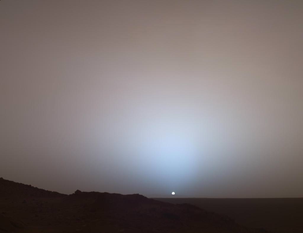
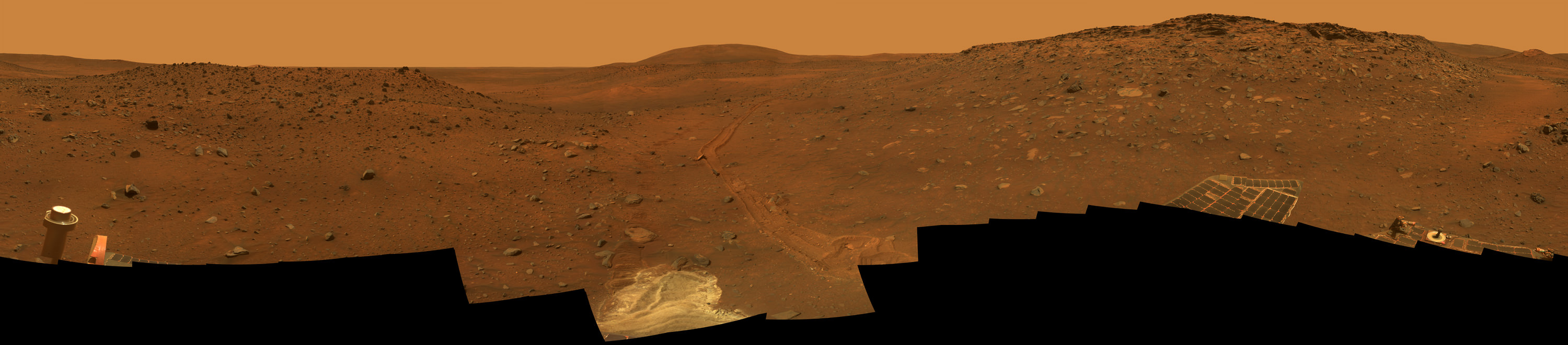
On May 19th, 2005, NASA’s Mars Exploration Rover Spirit captured this stunning view as the Sun sank below the rim of Gusev crater on Mars. This Panoramic Camera (Pancam) mosaic was taken around 6:07 in the evening of Sol 489. The terrain in the foreground is the rock outcrop “Jibsheet,” a feature that Spirit has been investigating for several weeks (rover tracks are dimly visible leading up to “Jibsheet”). The floor of Gusev crater is visible in the distance, and the Sun is setting behind the wall of Gusev some 80 km (50 miles) in the distance. Credit: NASA/JPL-Caltech/Texas A&M/Cornell
The goal was to “follow the water” as a potential enabler for past Martian microbes if they ever existed.
Together, the long-lived, golf cart sized robots proved that early Mars was warm and wet, billions of years ago – a key finding in the search for habitats conducive to life beyond Earth.
The solar powered robo duo were expected to last a mere three months – with a ‘warrenty’ of 90 Martian days (Sols).
Spirit endured the utterly extreme Red Planet climate for more than six years until communications ceased in 2010.
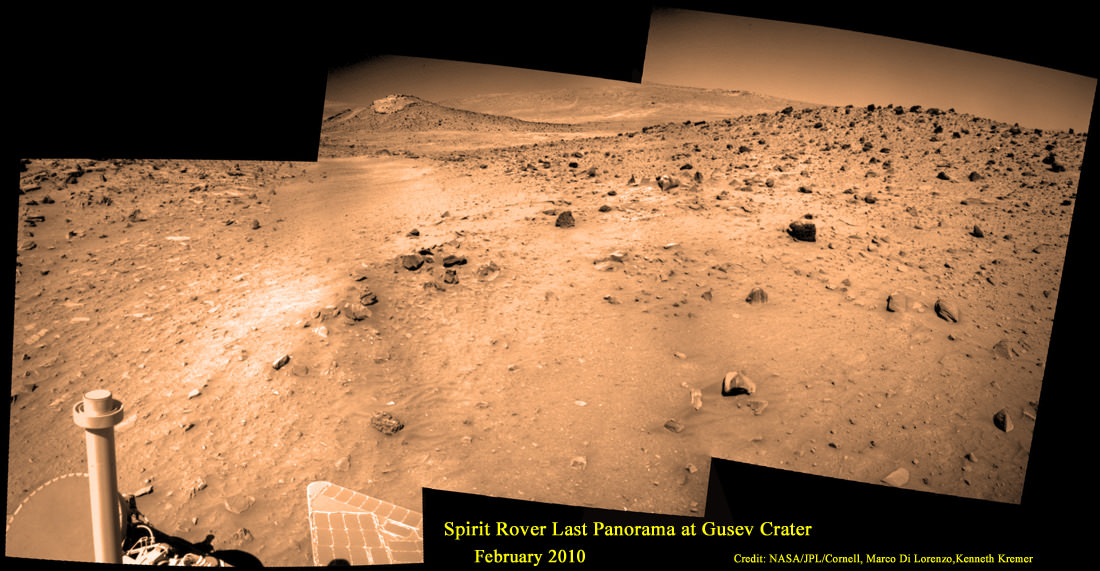
Last View from Spirit rover on Mars
Spirit’s last panorama from Gusev Crater was taken during February 2010 before her death from extremely low temperatures during her 4th Martian winter. Spirit was just 500 feet from her next science target – dubbed Von Braun – at center, with Columbia Hills as backdrop. Mosaic Credit: Marco Di Lorenzo/ Kenneth Kremer/ NASA/JPL/Cornell University.
Mosaic featured on Astronomy Picture of the Day (APOD) on 30 May 2011 – http://apod.nasa.gov/apod/ap110530.html
Opportunity lives on TODAY and is currently exploring by the summit of Solander Point on the western rim of a vast crater named Endeavour that spans some 22 kilometers (14 miles) in diameter.
“Because of the rovers’ longevity, we essentially got four different landing sites for the price of two,” says the rovers’ Principal Investigator, Steve Squyres of Cornell University, Ithaca, N.Y.
Here are the Top 10 MER discoveries from Ray Arvidson, Deputy Principal Investigator
1. Opportunity: Ancient Acidic Martian Lakes
The Meridiani plains Burns formation as sulfate-rich sandstones with hematitic concretions formed in ancient acidic and oxidizing shallow lakes and reworked into sand dunes and cemented by rising groundwaters.
‘Burns Cliff’ Color Panorama Opportunity captured this view of “Burns Cliff” after driving right to the base of this southeastern portion of the inner wall of “Endurance Crater.” The view combines frames taken by Opportunity’s panoramic camera between the rover’s 287th and 294th martian days (Nov. 13 to 20, 2004). The mosaic spans more than 180 degrees side to side. Credit: NASA/JPL-Caltech/Cornell
2. Opportunity: Phyllosilicate Clays at ‘Whitewater Lake’ at Endeavour Crater indicate Ancient Habitable Zone
At the rim of Endeavour crater and the Cape York rim segment the discovery of ferric and aluminous smectite [phyllosilicate] clays in the finely-layered Matijevic formation rocks that pre-exist the Endeavour impact event.
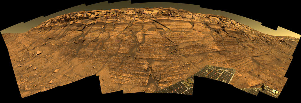
Pancam false-color view acquired on Sol 3066 (Sept. 8 2012) of fine-scale layering in the Whitewater Lake locality that is indicative of an ancient aqueous environment on Mars. Veneers have been resistant to wind erosion and enhanced the layered appearance of the outcrop. Layers are typically several millimeters thick. Credit: NASA/JPL-Caltech/Cornell/Arizona State University
Alteration in moderately acidic and reducing waters, perhaps mildly oxidizing for ferric smectites. These are the oldest rocks examined by Opportunity and the waters are much more habitable than waters that led to Burns formation.
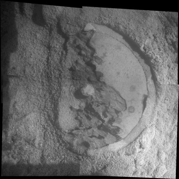
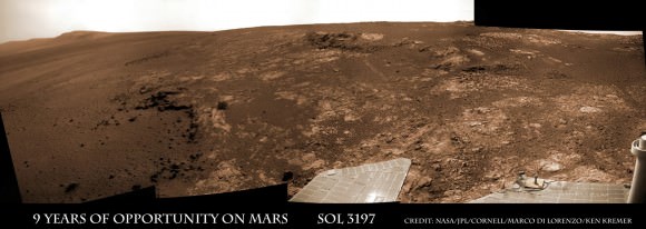
Opportunity rover discovered phyllosilicate clay minerals and calcium sulfate veins at the bright outcrops of ‘Whitewater Lake’, at right, imaged by the Navcam camera on Sol 3197 (Jan. 20, 2013, coinciding with her 9th anniversary on Mars. “Copper Cliff” is the dark outcrop, at top center. Darker “Kirkwood” outcrop, at left, is site of mysterious “newberries” concretions. This panoramic view was snapped from ‘Matijevic Hill’ on Cape York ridge at Endeavour Crater. Credit: NASA/JPL-Caltech/Cornell/Marco Di Lorenzo/Ken Kremer
3. Opportunity: Martian Meteorites
Many meteorites were found [throughout the long traverse] that are dispersed across the Meridiani plains landing site
4. Opportunity: Wind-blown sand ripples
Wind-blown sand ripples throughout the Meridiani plains relict from the previous wind regime, probably when Mars spin axis tilt was different than today’s value
5. Spirit: Opaline silica indicates Ancient Hydrothermal system
Discovery of Opaline silica at Home Plate, Gusev Crater. This formed in volcanic fumeroles and/or hydrothermal vents indicating that water was interacting with magma.
Spirit acquired this mosaic on Sol 1202 (May 21, 2007), while investigating the area east of the elevated plateau known as “Home Plate” in the “Columbia Hills.” The mosaic shows an area of disturbed soil, nicknamed “Gertrude Weise” by scientists, made by Spirit’s stuck right front wheel. The trench exposed a patch of nearly pure silica, with the composition of opal. It could have come from either a hot-spring environment or an environment called a fumarole, in which acidic, volcanic steam rises through cracks. Either way, its formation involved water, and on Earth, both of these types of settings teem with microbial life. Credit: NASA/JPL-Caltech/Cornell
6. Spirit: Carbonates at Comanche – see lead image above
The discovery of Fe-Mg [iron-magnesium] carbonates at the Comanche outcrop on Husband Hill, Gusev Crater, again showing that water interacted with magma.
Note: Carbonates form in neutral, non-acid water. This was the first time they were found and investigated examined on the surface Mars during Dec. 2005.
7. Spirit: Ferric sulfates moved by modern water
Ferric sulfates moved down the soil column by modern waters at Troy and Husband Hill in Gusev Crater.
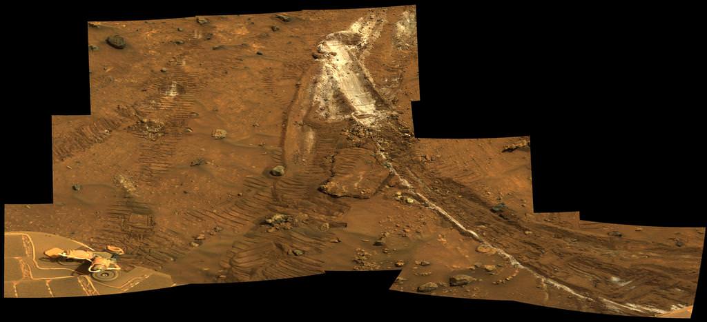
‘Calypso’ Panorama of Spirit’s View from ‘Troy’. This full-circle view from the panoramic camera (Pancam) on NASA’s Mars Exploration Rover Spirit shows the terrain surrounding the location called “Troy,” where Spirit became embedded in soft soil during the spring of 2009. The hundreds of images combined into this view were taken beginning on the 1,906th Martian day (or sol) of Spirit’s mission on Mars (May 14, 2009) and ending on Sol 1943 (June 20, 2009). Credit: NASA/JPL-Caltech/Cornell University
8. Spirit: Modern water alters rocks
Complex coatings on olivine basalts on the Gusev Crater plains showing modern water or frost has altered rock surfaces
9. Both rovers: Martian Dust Devils
The finding [and imaging] of dust devil frequency and dynamics, showing how dust and sand are moved by wind in the very thin Martian atmosphere.
Note: Wind action occasionally cleaning off the solar panels led to their unexpected longevity
See a dust devil imaged in our Solander Point mosaic below
Spirit Mars rover – view from Husband Hill summit – panels cleaned by wind action
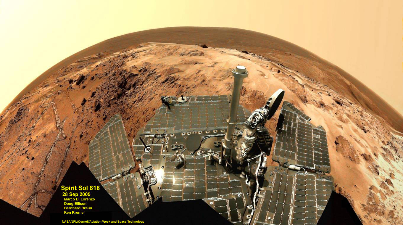
Spirit snapped this unique self portrait view from the summit of Husband Hill inside Gusev crater on Sol 618 on 28 September 2005. The rovers were never designed or intended to climb mountains. It took more than 1 year for Spirit to scale the Martian mountain. This image was created from numerous raw images by an international team of astronomy enthusiasts and appeared on the cover of the 14 November 2005 issue of Aviation Week & Space Technology magazine and the April 2006 issue of Spaceflight magazine. Also selected by Astronomy Picture of the Day (APOD) on 28 November 2005. Credit: NASA/JPL/Cornell/ Marco Di Lorenzo/Doug Ellison/Bernhard Braun/Ken Kremer – kenkremer.com
10. Both rovers: Atmospheric Argon measurements
Argon gas was used as a tracer of atmospheric dynamics by both rovers. It was measured by using the APXS (Alpha Particle X-Ray Spectrometer) on the robotic arm to measure the Martian atmosphere and detect argon
Another major discovery by Opportunity was the finding of hydrated mineral veins of calcium sulfate in the bench surrounding Cape York. The vein discovery is another indication of the ancient flow of liquid water in this region on Mars.
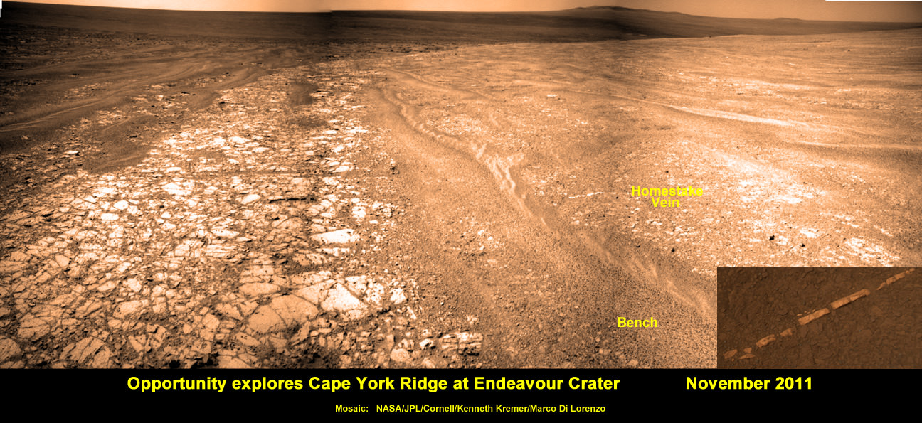
Opportunity discovers hydrated Mineral Vein at Endeavour Crater – November 2011. Opportunity determined that the ‘Homestake’ mineral vein was composed of calcium sulfate,or gypsum, while exploring around the base of Cape York ridge at the western rim of Endeavour Crater. The vein discovery indicates the ancient flow of liquid water at this spot on Mars. This panoramic mosaic of images was taken on Sol 2761, November 2011, and illustrates the exact spot of the mineral vein discovery. Featured on NASA Astronomy Picture of the Day (APOD) on 12 Dec 2011 – http://apod.nasa.gov/apod/ap111212.html. Credit: NASA/JPL/Cornell/Kenneth Kremer/Marco Di Lorenzo.
Altogether, Spirit snapped over 128,000 raw images, drove 4.8 miles (7.7 kilometers) and ground into 15 rock targets.
Opportunity is currently investigating a new cache of exposed clay mineral outcrops by the summit of Solander Point, a rim segment just south of Cape York and Matejivic Hill.
These new outcrops at ‘Cape Darby’ like those at ‘Esperance’ at Matijevic Hill were detected based on spectral observations by the CRISM spectrometer aboard NASA’s Mars Reconnaissance Orbiter (MRO) circling overhead, Arvidson told me.
Opportunity by Solander Point peak – 2nd Mars Decade Starts here!
NASA’s Opportunity rover captured this panoramic mosaic on Dec. 10, 2013 (Sol 3512) near the summit of “Solander Point” on the western rim of vast Endeavour Crater where she starts Decade 2 on the Red Planet. She is currently investigating summit outcrops of potential clay minerals formed in liquid water on her 1st mountain climbing adventure. See wheel tracks at center and dust devil at right. Assembled from Sol 3512 navcam raw images. Credit: NASA/JPL/Cornell/Marco Di Lorenzo/Ken Kremer-kenkremer.com
Today, Jan. 31, marks Opportunity’s 3563rd Sol or Martian Day roving Mars – for what was expected to be only a 90 Sol mission.
So far she has snapped over 188,200 amazing images on the first overland expedition across the Red Planet.
Her total odometry stands at over 24.07 miles (38.73 kilometers) since touchdown on Jan. 24, 2004 at Meridiani Planum.
Meanwhile on the opposite side of Mars, Opportunity’s younger sister rover Curiosity is trekking towards gigantic Mount Sharp. She celebrated 500 Sols on Mars on New Years Day 2014.
What’s Ahead for Opportunity in Decade 2 on Mars ?
Many more ground breaking discoveries surely lie ahead for Opportunity since she is currently exploring ancient terrain at Endeavour crater that’s chock full of minerals indicative of a Martian habitable zone.
She remains healthy and the solar panels are generating enough power to actively continue science investigations throughout her 6th frigid Martian winter!
NASA’s Opportunity Mars rover recorded the component images for this self-portrait near the peak of Solander Point and about three weeks before completing a decade of work on Mars. The rover’s panoramic camera (Pancam) took the images during the interval Jan. 3, 2014, to Jan. 6, 2014. Credit: NASA/JPL-Caltech/Cornell/Arizona State University
Therefore – Stay tuned here for Ken’s continuing Opportunity, Curiosity, Chang’e-3, LADEE, MAVEN, Mars rover and MOM news.
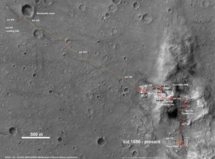
Spirit Rover traverse map from Gusev Crater landing site to Home Plate: 2004 to 2011Traverse Map for NASA’s Opportunity rover from 2004 to 2014
This map shows the entire path the rover has driven during a decade on Mars and over 3560 Sols, or Martian days, since landing inside Eagle Crater on Jan 24, 2004 to current location by Solander Point summit at the western rim of Endeavour Crater. Rover will spend 6th winter here atop Solander. Opportunity discovered clay minerals at Esperance – indicative of a habitable zone. Credit: NASA/JPL/Cornell/ASU/Marco Di Lorenzo/Ken Kremer – kenkremer.com
NASA's Opportunity Mars rover recorded the component images for this self-portrait near the peak of Solander Point and about three weeks before completing a decade of work on Mars. The rover's panoramic camera (Pancam) took the images during the interval Jan. 3, 2014, to Jan. 6, 2014. Credit: NASA/JPL-Caltech/Cornell/Arizona State University
Want to get an engineer excited? Give them a challenge. And the Opportunity rover has provided plenty of challenges in the past 10 years on Mars. Fun challenges, though; amazing tests of wit and skill, doing repairs on a rover that is sometimes a hundred million kilometers away. But with the longevity of the rovers also comes some amazing science.
The Opportunity rover is celebrating ten years on Mars. While the rovers were designed for about 1 kilometer of odometry, Oppy has now traveled 38.7 kilometers (24 miles). At yesterday’s briefing, the rover scientists and engineers said Opportunity is still in very good health and still is scientifically productive.
In the recent “selfie” image below, you can see how the rover is covered with dust, almost perfectly camouflaged with its environment. That montage was taken a few weeks ago, but recently there have been some wind cleaning events that have dusted off the solar panels, improving the solar power from 47% to 60%, which is higher than it has been through the past two Martian winters. This means they can continue to drive and explore even more, perhaps even during the upcoming winter.
Dust covering the rovers’ solar panels was one of the reasons that the initial estimates of the rovers’ life was only for 90 days. The dust cleaning events have been an unexpected benefit that has allowed for the long missions for the MER rovers.
Beyond the scientific findings of potential habitability announced yesterday, John Callas, project manager for the Mars Exploration Rovers said both Spirit and Opportunity have given us a great intangible.
“Through these rovers our species has gone to work on Mars, and now a generation has grown up with these rovers and have been inspired by them,” Callas said. “Because of these rovers Earthlings have become Martians too, dual citizens, if you will. We now live in a larger world, a world than now extends beyond our own home planet these rovers have made Mars our neighborhood and our backyard, something truly remarkable.”
Pancam false-color view acquired on Sol 3066 (Sept. 8 2012) of fine-scale layering in the Whitewater Lake locality that is indicative of an ancient aqueous environment on Mars. Veneers have been resistant to wind erosion and enhanced the layered appearance of the outcrop. Layers are typically several millimeters thick. Credit: NASA/JPL-Caltech/Cornell/Arizona State University
After a decade of roving relentlessly on the Red Planet, NASA’s Opportunity rover discovered rocks that preserve the best evidence yet that ancient Mars was the most conducive time period for the formation of life on our Solar System’s most Earth-like Planet, according to the science leaders of the mission.
Opportunity found the rocks – laden with clay minerals – barely over half a year ago in the spring of 2013, at an outcrop named ‘Whitewater Lake’ along an eroded segment of a vast crater named Endeavour that spans some 22 kilometers (14 miles) in diameter.
“These rocks are older than any we examined earlier in the mission, and they reveal more favorable conditions for microbial life than any evidence previously examined by investigations with Opportunity,” says Opportunity Deputy Principal Investigator Ray Arvidson, a professor at Washington University in St. Louis.
Opportunity investigated the rocks at a spot dubbed Matejivic Hill where researchers believe iron-rich smectite was produced in an aqueous environment some 4 billion years ago that was relatively benign and with a nearly neutral pH – thus offering potential life forms a habitable zone with a far better chance to originate and thrive for perhaps as long as hundreds of millions of years.
The new scientific findings are being published in the journal Science on Jan. 24, which just happens to exactly coincide with Opportunity’s landing on the Red Planet ten years ago at Meridiani Planum.
Matejivic Hill is located on the Cape York rim segment of Endeavour crater. See locations on our Opportunity route map below.
“The punch line here is that the oldest rocks Opportunity has examined were formed under very mild conditions — conditions that would have been a much better niche for life, and also much better for the preservation of organic materials that would have been produced,” said Arvidson at a NASA media briefing today, Jan. 23.
Opportunity rover discovered phyllosilicate clay minerals and calcium sulfate veins at the bright outcrops of ‘Whitewater Lake’, at right, imaged by the Navcam camera on Sol 3197 (Jan. 20, 2013, coinciding with her 9th anniversary on Mars. “Copper Cliff” is the dark outcrop, at top center. Darker “Kirkwood” outcrop, at left, is site of mysterious “newberries” concretions. This panoramic view was snapped from ‘Matijevic Hill’ on Cape York ridge at Endeavour Crater. Credit: NASA/JPL-Caltech/Cornell/Marco Di Lorenzo/Ken Kremer
Immediately after landing on Mars on Jan.24, 2004 inside Eagle crater, the six wheeled robot found rocks within her eyesight that provided concrete evidence that eons ago Mars was much warmer and wetter compared to the cold, arid conditions that exist today.
Although those sulfate rich rocks proved that liquid water once flowed on the surface of the Red Planet, they also stem from a time period with a rather harsh environment that was extremely acidic, containing significant levels of sulfuric acid that would not be friendly to the formation or sustainability of potential Martian life forms.
“Evidence is thus preserved for water-rock interactions of the aqueous environments of slightly acidic to circum-neutral pH that would have been more favorable for prebiotic chemistry and microorganisms than those recorded by younger sulfate-rich rocks at Meridiani Planum,” Ardivson wrote in the Science paper, of which he is the lead author, along with many other team members.
NASA’s Opportunity Mars rover recorded the component images for this self-portrait near the peak of Solander Point and about three weeks before completing a decade of work on Mars. The rover’s panoramic camera (Pancam) took the images during the interval Jan. 3, 2014, to Jan. 6, 2014. Credit: NASA/JPL-Caltech/Cornell/Arizona State University
The science team directed Opportunity to Matejivic Hill and the ‘Whitewater Lake’ area of outcrops based on predictions from spectral observations collected from the CRISM spectrometer aboard one of NASA’s spacecraft circling overhead the Red Planet – the powerful Mars Reconnaissance Orbiter (MRO).
Opportunity arrived at Mars barely 3 weeks after her twin sister, Spirit on 3 January 2004.
The long lived robot has been methodically exploring along the rim of Endeavour crater since arriving in August 2011.
The newly published results from Opportunity correlate very well with those from sister rover Curiosity which likewise found a habitable zone where drinkable water once flowed on the opposite side of Mars.
The combined discoveries from the golf cart sized Opportunity and the SUV sized Curiosity tell us that the presence of liquid water was widespread on ancient Mars.
“The more we explore Mars, the more interesting it becomes. These latest findings present yet another kind of gift that just happens to coincide with Opportunity’s 10th anniversary on Mars,” said Michael Meyer, lead scientist for NASA’s Mars Exploration Program.
“We’re finding more places where Mars reveals a warmer and wetter planet in its history. This gives us greater incentive to continue seeking evidence of past life on Mars.”
Opportunity is currently investigating a new cache of clay mineral outcrops by the summit of Solander Point, a rim segment just south of Cape York and Matejivic Hill.
These outcrops were likewise detected by the CRISM spectrometer aboard MRO. The hunt for these outcrops was detailed in earlier discussions I had with Ray Arvidson.
Opportunity by Solander Point peak – her 1st mountain climbing adventure. NASA’s Opportunity rover captured this panoramic mosaic on Dec. 10, 2013 (Sol 3512) near the summit of “Solander Point” on the western rim of Endeavour Crater where she is investigating outcrops of potential clay minerals. Assembled from Sol 3512 navcam raw images. Credit: NASA/JPL/Cornell/Marco Di Lorenzo/Ken Kremer-kenkremer.com
Today marks Opportunity’s 3555th Sol or Martian Day roving Mars – for what was expected to be only a 90 Sol mission.
So far she has snapped over 188,200 amazing images on the first overland expedition across the Red Planet.
Her total odometry stands at over 24.07 miles (38.73 kilometers) since touchdown on Jan. 24, 2004 at Meridiani Planum.
Meanwhile on the opposite side of Mars, Opportunity’s younger sister rover Curiosity is trekking towards gigantic Mount Sharp. She celebrated 500 Sols on Mars on New Years Day 2014.
Opportunity by Solander Point peak – 2nd Mars Decade Starts here! NASA’s Opportunity rover captured this panoramic mosaic on Dec. 10, 2013 (Sol 3512) near the summit of “Solander Point” on the western rim of Endeavour Crater where she starts Decade 2 on the Red Planet. She is currently investigating outcrops of potential clay minerals formed in liquid water on her 1st mountain climbing adventure. Assembled from Sol 3512 navcam raw images. Credit: NASA/JPL/Cornell/Marco Di Lorenzo/Ken Kremer-kenkremer.comTraverse Map for NASA’s Opportunity rover from 2004 to 2014
This map shows the entire path the rover has driven during a decade on Mars and over 3540 Sols, or Martian days, since landing inside Eagle Crater on Jan 24, 2004 to current location by f Solander Point summit at the western rim of Endeavour Crater. Rover will spnd 6th winter here atop Solander. Opportunity discovered clay minerals at Esperance – indicative of a habitable zone. Credit: NASA/JPL/Cornell/ASU/Marco Di Lorenzo/Ken Kremer
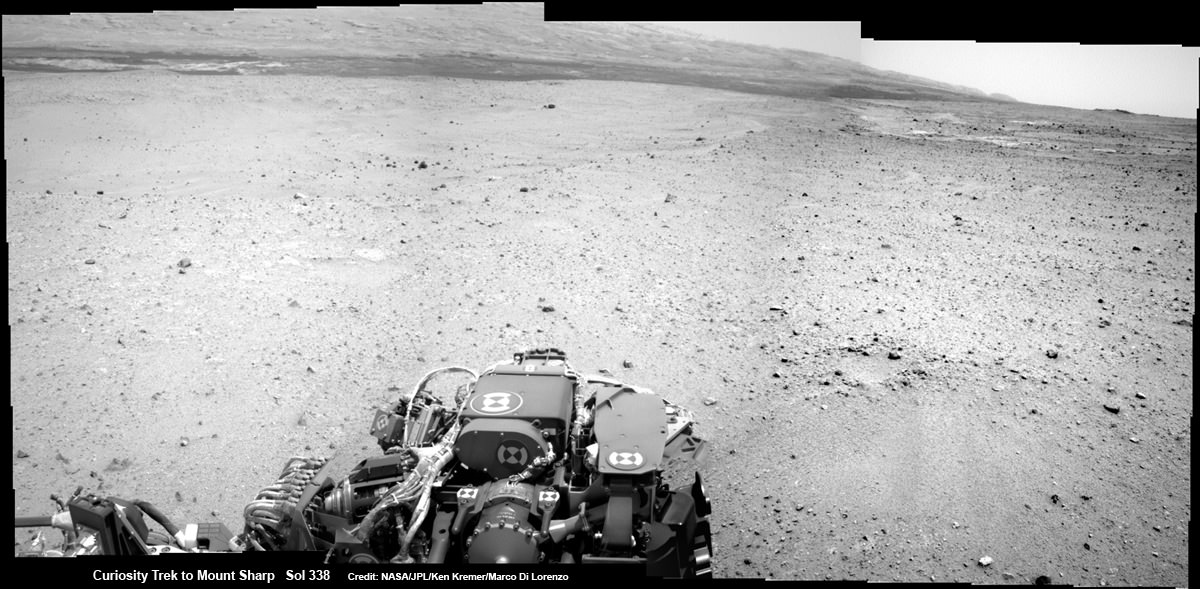
Curiosity On the Road to Mount Sharp and treacherous Sand Dunes - Sol 338 - July 19. Curiosity captured this panoramic view of the path ahead to the base of Mount Sharp and potentially dangerous sand dunes after her most recent drive on July 19, 2013. She must safely cross over the dark dune field to climb and reach the lower sedimentary layers of Mount Sharp. Credit: NASA/JPL-Caltech/Ken Kremer-(kenkremer.com)/Marco Di Lorenzo
Curiosity On the Road to Mount Sharp and treacherous Sand Dunes – Sol 338 – July 19
Curiosity captured this panoramic view of the path ahead to the base of Mount Sharp and potentially dangerous sand dunes after her most recent drive on July 19, 2013. She must safely cross over the dark dune field to climb and reach the lower sedimentary layers of Mount Sharp. Stowed robotic arm on rover deck seen at center.
See JPL traverse map below pinpointing the view from this location
Credit: NASA/JPL-Caltech/Ken Kremer-(kenkremer.com)/Marco Di Lorenzo[/caption]
NASA’s state-of-the-art Curiosity Mars rover is stepping up the driving pace and rolling relentlessly across alien Martian terrain towards the towering mystery mountain known as Mount Sharp that’s holds the keys to the Red Planets past evolution and whether its an abode for Life.
To uncover the latest scoop on the robots otherworldly adventures, Universe Today conducted an exclusive interview with the Curiosity Project Manager Jim Erickson, of NASA’s Jet Propulsion Laboratory (JPL).
In Part 2 of my conversation with Jim Erickson we’ll discuss more about the rover’s traverse across alien territory that’s simultaneously a science gold mine and a potential death trap, as well as Comet ISON and nighttime observations and science planning.
“When Comet ISON is in the sky I’m sure we’ll do some observations of it depending on when its visible,” Erickson told me.
Today, July 20, is Sol 339 of the rovers mission to Mars. And also the 44th anniversary of the 1st human Moonwalks in 1969.
And Curiosity just drove another 34 meters yesterday, Sol 338 (July 19) – for a total distance exceeding 1.1 kilometers.
Curiosity’s Traverse Map Through Sol 338
This map shows the route driven by NASA’s Mars rover Curiosity through Sol 338 of the rover’s mission on Mars (July 19, 2013). Numbering of the dots along the line indicate the sol number of each drive. North is up. The scale bar is 200 meters (656 feet). From Sol 337 to Sol 338, Curiosity had driven a straight line distance of about 122.90 feet (32.59 meters). The base image from the map is from the High Resolution Imaging Science Experiment Camera (HiRISE) in NASA’s Mars Reconnaissance Orbiter. Image Credit: NASA/JPL-Caltech/Univ. of Arizona
As for Martian sand dunes, they dunes offer both exciting opportunities and lurking dangers to the rovers well being.
Indeed fields of Martian sand dunes are potential death traps and the six wheeled rover has no choice but to traverse across an extensive dune field as she closes in on the base of Mount Sharp
Recall that NASA’s now long lived Opportunity rover nearly perished rather early in her mission at the ‘Purgatory’ dune field on Meridiani Planum.
Spirit died after more than six highly productive years on the Red Planet when she was unable to escape a hidden sand trap she had accidentally fallen wheels deep into as the vehicle was merrily roving beside an eroded volcano at Gusev Crater on the approach to the mysterious Von Braun mound.
So, dunes are serious business
Here is Part 2 of my interview with Jim Erickson.
Ken Kremer: Which direction is Curiosity headed? Will she be following the southwest route shown in the ellipse on the JPL map – see traverse map below – or reinvestigate any other spots nearer the landing site first?
Jim Erickson: We have a good general idea. We will be on a general heading of southwest, not west which would have taken us back near the landing site [at Bradbury Landing].
Curiosity Route Map From ‘Glenelg’ to Mount Sharp
This map shows where NASA’s Mars rover Curiosity landed in August 2012 at “Bradbury Landing”; the area where the rover worked from November 2012 through May 2013 at and near the “John Klein” target rock in the “Glenelg” area; and the mission’s next major destination, the entry point to the base of Mount Sharp. Credit: NASA/JPL-Caltech/Univ. of Arizona
Ken: So the rover will not pass by the Hottah outcrop of concretions formed in water and investigated early in the mission?
Jim Erickson: No. The intent for the ellipse [shown on the map] is that we will be traveling in it to get to an area where the sand dunes look better for crossing [to the base of Mount Sharp]. When we get there we will know reality. And we will pick a safe spot to cross.
The dunes can be both an issue or in some cases easy sailing.
My experience on MER [Spirit & Opportunity] was that when you are going with the dunes, down a trough, they tend to be well packed and that was great driving.
But if you need to make a right turn, that can be a challenge for a couple of reasons. It is harder to see what is inside the next trough. And you have to drive to the top of the dune. So your driving is limited until you can see what’s inside the next dune.
Level ground is more straightforward. You know exactly what to look for if the terrain doesn’t change the next day. So you can do the same thing you did last night based on the new set of images.
If the terrain is changing then it gets more complicated.
Ken: Will you be straddling the dunes or driving alongside some safe distance away?
Jim Erickson: We have been going through various options of different planned routes. At some point we have to go with the dune directions.
So we’ll be traveling down some troughs later on. We will definitely have to pick our way through them.
Part of it is gaining experience in this new area of Mars with how the sand dunes and troughs themselves actually are.
So we’ll have to wait and see. We know we’ll have to deal with the dunes. Depending on how these dunes act we may have to do different things compared to MER.
Ken: What’s the health status of Curiosity?
Jim Erickson: We’re doing great. There are always active things we are looking at.
We had the anomaly before conjunction and have put in place a number of software mitigations and reconfigured the A side memory so that we can work around the hardware problem that happened. If we have another problem, both the A and B side memory can handle it gracefully, unlike the last time.
Ken: Describe the rover’s power situation? And the ability to do nighttime observations like the recent imagery of Phobos rising?
And certainly will be able to do nighttime observations.
Ken: What’s the plan for observations of Comet ISON?
Jim Erickson: When we get to the point when Comet ISON is in the sky I’m sure we’ll do some observations of it, depending on the time period when its visible.
Note: NASA’s Curiosity and Opportunity rovers will have a view of ISON in October with Oct. 1, 2013, being the comet’s closest approach to Mars.
NASA’s Directory of Planetary Science Jim Green told me previously that NASA is very interested in using its orbiting and surface assets at Mars to study Comet ISON. It’s a once in a lifetime opportunity.
Early October 2013 will be the prime viewing time for ISON from the vicinity of the Red Planet.
Let’s hope that NASA’s quartet of spacecraft and ESA’s lone orbiter capture some breathtaking imagery and science observations.
Ken: About the recent Phobos nighttime images, a Universe Today reader asked whether the other points of light beside Phobos were stars or hot pixels?
Jim Erickson: The specks are hot pixels [not stars], intensified by the long exposure times for the image.
Video Caption: ‘Phobos Rising’ – This movie clip shows Phobos, the larger of the two moons of Mars, passing overhead, as observed by Curiosity in a series of images centered straight overhead starting shortly after sunset on June 28, 2013. Phobos first appears near the lower center of the view and moves toward the top of the view. The apparent ring is an imaging artifact. The other bright spots are hot pixels – not stars. Credit: NASA/JPL-Caltech
Ken: How about the prospects for science along the way to the mountain?
Jim Erickson: We expect to do science along the way to Mount Sharp, for example in terms of atmospheric measurements.
We will stop at some preplanned sites. Exactly which ones is still being debated by the scientists.
And we’ll do the right thing – If we see something spectacular along the way. Just because we may not have identified it previously, that doesn’t mean we won’t stop and examine it.
Things are going very well, says Erickson.
Erickson has worked in key positions on many NASA planetary science missions dating back to Viking in the 1970’s. These include the Galileo mission to Jupiter, both MER rovers Spirit & Opportunity, as well as a stint with the Mars Reconnaissance Orbiter (MRO).
I’ll have more upcoming from Jim about Curiosity’s Martian drilling activities.
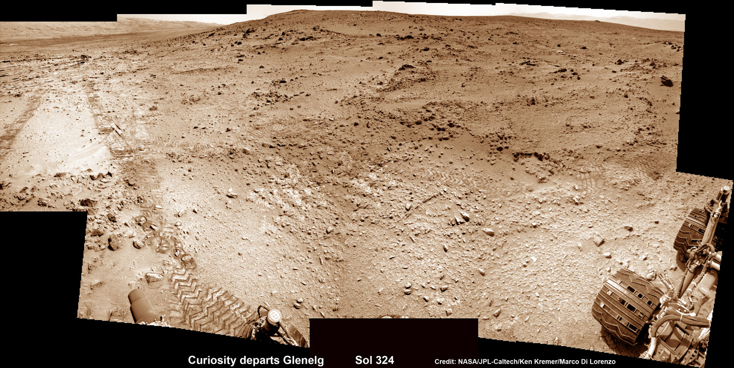
As of today (July 20) Curiosity has driven nine times since leaving the Glenelg/Yellowknife Bay area on July 4 (Sol 324), totaling nearly 300 meters.
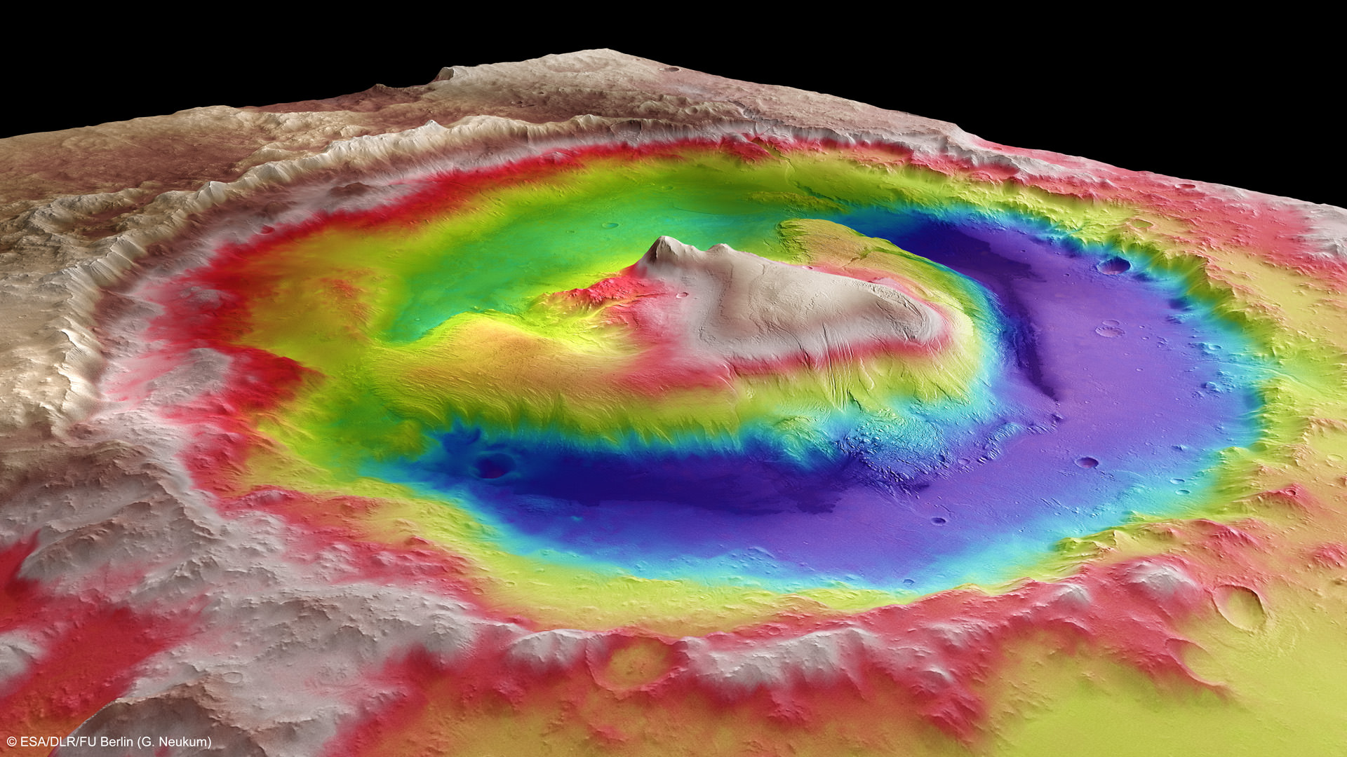
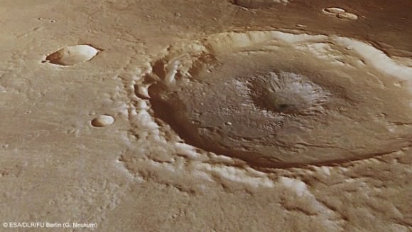
This photomosic shows NASA’s Curiosity departing at last for Mount Sharp- her main science destination. Note the wheel tracks on the Red Planet’s surface. The navcam camera images were taken on July 4, 2013 (Sol 324). Credit: NASA/JPL-Caltech/Ken Kremer (kenkremer.com)/Marco Di LorenzoMount Sharp inside Gale Crater – is the primary destination of NASA’s Curiosity rover mission to Mars. Curiosity landed on the right side of the mountain as shown here, near the dune field colored dark blue. Mount Sharp dominates Gale Crater. It is 3.4 mile (5.5 km) high. Gale Crater is 154 km wide. This image was taken by the High Resolution Stereo Camera (HRSC) of ESA’s Mars Express orbiter. Credit: ESA/DLR/FU Berlin (G. Neukum)
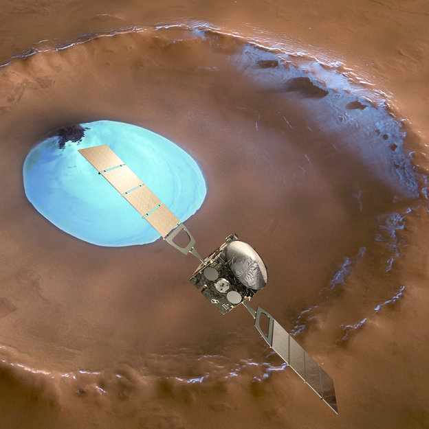
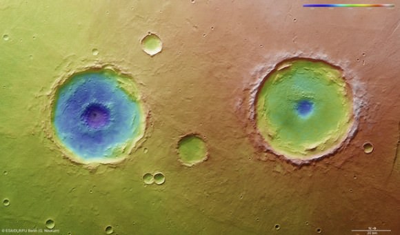
Mars Express over water-ice crater. ESA Celebrates 10 Years since the launch of Mars Express. This artists concept shows Mars Express set against a 35 km-wide crater in the Vastitas Borealis region of Mars at approximately 70.5°N / 103°E. The crater contains a permanent patch of water-ice that likely sits upon a dune field – some of the dunes are exposed towards the top left in this image. Copyright ESA/DLR/FU-Berlin-G.Neukum
This week marks the 10th anniversary since the launch of the European Space Agencies’ (ESA) Mars Express orbiter from the Baikonur Cosmodrome in Russia on June 2, 2003 and a decade of ground breaking science discoveries at the Red Planet.
2003 was a great year for Mars exploration as it also saw the dual liftoffs of NASA’s now legendary rovers Spirit & Opportunity from Cape Canaveral in Florida.
The immense quantity and quality of science data returned from Mars Express -simultaneously with Spirit and Opportunity – has completely transformed our understanding of the history and evolution of the Red Planet.
All three spacecraft have functioned far beyond their original design lifetime.
Earth’s exploration fleet of orbiters, landers and rovers have fed insights to each other that vastly multiplied the science output compared to working solo during thousands and thousands of bonus Sols at Mars.
Inside a central pit crater. Perspective view of a 50 km diameter crater in Thaumasia Planum. The image was made by combining data from the High-Resolution Stereo Camera on ESA’s Mars Express with digital terrain models. The image was taken on 4 January 2013, during orbit 11467, and shows a close up view of the central ‘pit’ of this crater, which likely formed by a subsurface explosion as the heat from the impact event rapidly vapourised water or ice lying below the surface. Copyright ESA/DLR/FU-Berlin-G.Neukum
Mars Express derived its name from an innovative new way of working in planetary space science that sped up the development time and cut costs in the complex interactive relationships between the industrial partners, space agencies and scientists.
Indeed the lessons learned from building and operating Mars Express spawned a sister ship, Venus Express that also still operates in Venusian orbit.
Mars Express (MEX) achieved orbit in December 2003.
MEX began science operations in early 2004 with an array of seven instruments designed to study all aspects of the Red Planet, including its atmosphere and climate, and the mineralogy and geology of the surface and subsurface with high resolution cameras, spectrometers and radar.
The mission has been granted 5 mission extensions that will carry it to at least 2014.
The mission has been wildly successful except for the piggybacked lander known as Beagle 2, which was British built.
Beagle 2The ambitious British lander was released from the mothership on December 19, 2003, six days before MEX braked into orbit around Mars. Unfortunately the Beagle 2 was never heard from again as it plummeted to the surface and likely crashed.
The high resolution camera (HRSC) has transmitted thousands of dramatic 3D images all over Mars ranging from immense volcanoes, steep-walled canyons, dry river valleys, ancient impact craters of all sizes and shapes and the ever-changing polar ice caps.
It carried the first ever radar sounder (MARSIS) to orbit another planet and has discovered vast caches of subsurface water ice.
MEX also played a significant role as a data relay satellite for transmissions during the landings of NASA’s Phoenix lander and Curiosity rover. It also occasionally relays measurements from Spirit & Opportunity to NASA.
Arima twins topography. This colour-coded overhead view is based on an ESA Mars Express High-Resolution Stereo Camera digital terrain model of the Thaumasia Planum region on Mars at approximately 17°S / 296°E. The image was taken during orbit 11467 on 4 January 2013. The colour coding reveals the relative depth of the craters, in particular the depths of their central pits, with the left-hand crater penetrating deeper than the right (Arima crater). Copyright: ESA/DLR/FU-Berlin-G.Neukum
Here is a list of the Top 10 Discoveries from Mars Express from 2003 to 2013:
Mars Express mineralogy maps. This series of five maps shows near-global coverage of key minerals that help plot the history of Mars. The map of hydrated minerals indicates individual sites where a range of minerals that form only in the presence of water were detected. The maps of olivine and pyroxene tell the story of volcanism and the evolution of the planet’s interior. Ferric oxides, a mineral phase of iron, are present everywhere on the planet: within the bulk crust, lava outflows and the dust oxidised by chemical reactions with the martian atmosphere, causing the surface to ‘rust’ slowly over billions of years, giving Mars its distinctive red hue. Copyright: ESA/CNES/CNRS/IAS/Université Paris-Sud, Orsay; NASA/JPL/JHUAPL; Background images: NASA MOLA#1. First detection of hydrated minerals in the form of phyllosilicates and hydrated sulfates – evidence of long periods of flowing liquid water from the OMEGA visible and infrared spectrometer provided confirmation that Mars was once much wetter than it is today and may have been favorable for life to evolve.
#2. Possible detection of methane in the atmosphere from the Planetary Fourier Spectrometer (PFS) which could originate from biological or geological activity.
#3. Identification of recent glacial landforms via images from the High Resolution Stereo Camera (HRSC) are stem from viscous flow features composed of ice-rich material derived from adjacent highlands.
#4. Probing the polar regions. OMEGA and MARSIS determined that the south pole consists of a mixture frozen water ice and carbon dioxide. If all the polar ice melted the planet would be covered by an ocean 11 meters deep.
#5. Recent and episodic volcanism perhaps as recently as 2 million years ago. Mars has the largest volcanoes in the solar system . They are a major factor in the evolution of the martian surface, atmosphere and climate.
#6. Estimation of the current rate of atmospheric escape, helps researchers explain how Mars changed from a warm, wet place to the cold, dry place it is today.
#8. A new, meteoric layer in the martian ionosphere created by fast-moving cosmic dust which burns up as it hits the atmosphere.
#9. Unambiguous detection of carbon dioxide clouds. The freezing and vaporisation of CO2 is one of the main climatic cycles of Mars, and it controls the seasonal variations in surface air pressure.
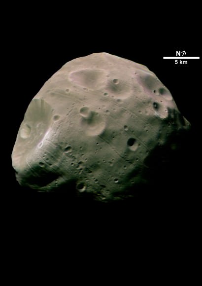
#10. Unprecedented probing of the Martian moon Phobos – which could be a target for future landers and human missions.
The Mars-facing side of Phobos. Credit: ESA/DLR/FU Berlin (G. Neukum)
And don’t forget to “Send Your Name to Mars” aboard NASA’s MAVEN orbiter- details here. Deadline: July 1, 2013
June 23: “Send your Name to Mars on MAVEN” and “CIBER Astro Sat, LADEE Lunar & Antares Rocket Launches from Virginia”; Rodeway Inn, Chincoteague, VA, 8 PM
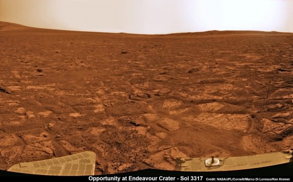
Opportunity established a new American driving record for a vehicle on another world on May 15, 2013 (Sol 3309) and made history by driving ahead from this point at Cape York. This navcam mosaic shows the view forward to her next destinations of Solander Point and Cape Tribulation along the lengthy rim of huge Endeavour crater spanning 14 miles (22 km) in diameter. Opportunity discovered clay minerals at Cape York and stands as the most favorable location for Martian biology discovered during her entire nearly 10 year long mission to Mars. Credit: NASA/JPL/Cornell/Kenneth Kremer/Marco Di Lorenzo
NASA’s Opportunity Mars rover discovered clay minerals at Cape York ridge along the rim of Endeavour crater – seen in this photo mosaic – which stands as the most favorable location for Martian biology discovered during her entire nearly 10 year long mission to Mars. Opportunity also established a new American driving record for a vehicle on another world on May 15, 2013 (Sol 3309) and made history by driving ahead from this point at Cape York. This navcam photo mosaic shows the view forward to her next destinations of Solander Point and Cape Tribulation along the lengthy rim of huge Endeavour crater spanning 14 miles (22 km) in diameter.
Credit: NASA/JPL/Cornell/Ken Kremer (kenkremer.com)/Marco Di Lorenzo Updated: Illustrated below with a collection of imagery, mosaics and route maps[/caption]
Now nearly a decade into her planned 3 month only expedition to Mars, NASA’s longest living rover Opportunity, struck gold and has just discovered the strongest evidence to date for an environment favorable to ancient Martian biology – and she has set sail hunting for a motherlode of new clues amongst fabulous looking terrain!!
Barely two weeks ago in mid-May 2013, Opportunity’s analysis of a new rock target named “Esperance” confirmed that it is composed of a “clay that had been intensely altered by relatively neutral pH water – representing the most favorable conditions for biology that Opportunity has yet seen in the rock histories it has encountered,” NASA said in a statement.
The finding of a fractured rock loaded with clay minerals and ravaged by flowing liquid water in which life could have thrived amounts to a scientific home run for the golf cart sized rover!
“Water that moved through fractures during this rock’s history would have provided more favorable conditions for biology than any other wet environment recorded in rocks Opportunity has seen,” said the mission’s principal investigator Prof. Steve Squyres of Cornell University, Ithaca, N.Y.
Opportunity accomplished the ground breaking new discovery by exposing the interior of Esperance with her still functioning Rock Abrasion Tool (RAT) and examining a pristine patch using the microscopic camera and X-Ray spectrometer on the end of her 3 foot long robotic arm.
The pale rock in the upper center of this image, about the size of a human forearm, includes a target called “Esperance,” which was inspected by NASA’s Mars Exploration Rover Opportunity. Data from the rover’s alpha particle X-ray spectrometer (APXS) indicate that Esperance’s composition is higher in aluminum and silica, and lower in calcium and iron, than other rocks Opportunity has examined in more than nine years on Mars. Preliminary interpretation points to clay mineral content due to intensive alteration by water. Credit: NASA/JPL-Caltech/Cornell/Arizona State Univ
The robot made the discovery at the conclusion of a 20 month long science expedition circling around a low ridge called “Cape York” – which she has just departed on a southerly heading trekking around the eroded rim of the huge crater named “Endeavour.”
“Esperance was so important, we committed several weeks to getting this one measurement of it, even though we knew the clock was ticking.”
Esperance stems from a time when the Red Planet was far warmer and wetter billions of years ago.
“What’s so special about Esperance is that there was enough water not only for reactions that produced clay minerals, but also enough to flush out ions set loose by those reactions, so that Opportunity can clearly see the alteration,” said Scott McLennan of the State University of New York, Stony Brook, a long-term planner for Opportunity’s science team.
Close-Up of ‘Esperance’ After Abrasion by Opportunity This mosaic of four frames shot by the microscopic imager on the robotic arm of NASA’s Mars Exploration Rover Opportunity shows a rock target called “Esperance” after some of the rock’s surface had been removed by Opportunity’s rock abrasion tool, or RAT. The component images were taken on Sol 3305 on Mars (May 11, 2013). The area shown is about 2.4 inches (6 centimeters) across. Credit: NASA/JPL-Caltech/Cornell/USGS
Esperance is unlike any rock previously investigated by Opportunity; containing far more aluminum and silica which is indicative of clay minerals and lower levels of calcium and iron.
Most, but not all of the rocks inspected to date by Opportunity were formed in an environment of highly acidic water that is extremely harsh to most life forms.
Clay minerals typically form in potentially drinkable, neutral water that is not extremely acidic or basic.
Previously at Cape York, Opportunity had found another outcrop containing a small amount of clay minerals formed by exposure to water called “Whitewater Lake.”
“There appears to have been extensive, but weak, alteration of Whitewater Lake, but intense alteration of Esperance along fractures that provided conduits for fluid flow,” said Squyres.
Opportunity rover discovered phyllosilicate clay minerals and calcium sulfate veins at the bright outcrops of ‘Whitewater Lake’, at right, imaged by the Navcam camera on Sol 3197 (Jan. 20, 2013, coinciding with her 9th anniversary on Mars. “Copper Cliff” is the dark outcrop, at top center. Darker “Kirkwood” outcrop, at left, is site of mysterious “newberries” concretions. This panoramic view was snapped from ‘Matijevic Hill’ on Cape York ridge at Endeavour Crater. Credit: NASA/JPL-Caltech/Cornell/Marco Di Lorenzo/Ken Kremer
Cape York is a hilly segment of the rim of Endeavour crater which spans 14 miles (22 km) across – where the robot arrived in mid-2011 and will spend her remaining life.
Opportunity has now set sail for her next crater rim destination named “Solander Point”, an area about 1.4 miles (2.2 kilometers) away – due south from “Cape York.”
“Our next destination will be Solander Point,” Squyres told Universe Today.
Along the way, Opportunity will soon cross “Botany Bay” and “Sutherland Point”, last seen when Opportunity first arrived at Cape York.
Eventually she will continue further south to a rim segment named ‘Cape Tribulation’ which holds huge caches of clay minerals.
The rover must arrive at “Solander Point” before the onset of her 6th Martian winter so that she can be advantageously tilted along north facing slopes to soak up the maximum amount of sun by her power generating solar wings. She might pull up around August.
On the other side of Mars, Opportunity’s new sister rover Curiosity also recently discovered clay minerals on the floor of her landing site inside Gale Crater.
Curiosity found the clay minerals – and a habitat that could support life – after analyzing powdery drill tailings from the Yellowknife Bay basin worksite with her on board state-of-the-art chemistry labs.
Just a week ago on May 15 (Sol 3309), Opportunity broke through the 40 year old American distance driving record set back in December 1972 by Apollo 17 astronauts Eugene Cernan and Harrison Schmitt.
But she is not sitting still resting on her laurels!
This past week the robots handlers’ back on Earth put the pedal to the metal and pushed her forward another quarter mile during 5 additional drives over 7 Sols, or Martian days. Thus her total odometry since landing on 24 January 2004 now stands at 22.45 miles (36.14 kilometers).
Opportunity will blast through the world record milestone of 23 miles (37 kilometers) held by the Lunokhod 2 lunar rover (from the Soviet Union), somewhere along the path to “Solander Point” in the coming months.
Opportunity captures the eerie Martian scenery looking south across Botany Bay from the southern tip of Cape York to her next destination – Solander Point, about 1 mile (1.6 km) away. This navcam photo mosaic was taken on Sol 3317, May 23, 2013. Credit: NASA/JPL/Cornell//Marco Di Lorenzo/Ken Kremer (kenkremer.com)
Endeavour Crater features terrain with older rocks than previously inspected and unlike anything studied before by Opportunity. It’s a place no one ever dared dream of reaching prior to Opportunity’s launch in the summer of 2003 and landing on the Meridiani Planum region in 2004.
Signatures of clay minerals, or phyllosilicates, were detected at several spots at Endeavour’s western rim by observations from the Compact Reconnaissance Imaging Spectrometer for Mars (CRISM) aboard NASA’s Mars Reconnaissance Orbiter (MRO).
“The motherlode of clay minerals is on Cape Tribulation. The exposure extends all the way to the top, mainly on the inboard side,” says Ray Arvidson, the rover’s deputy principal investigator at Washington University in St. Louis.
Stay tuned for the continuing breathtaking adventures of NASA’s sister rovers Opportunity and Curiosity!
And don’t forget to “Send Your Name to Mars” aboard NASA’s MAVEN orbiter- details here. Deadline: July 1, 2013
Traverse Map for NASA’s Opportunity rover from 2004 to 2013 to Record Setting Drive on May 15. This map shows the entire path the rover has driven during more than 9 years and over 3318 Sols, or Martian days, since landing inside Eagle Crater on Jan 24, 2004 to current location heading south to Solander Point from Cape York ridge at the western rim of Endeavour Crater. On May 15, 2013 Opportunity drove 263 feet (80 meters) southward – achieving a total traverse distance on Mars of 22.22 miles (35.76 kilometers) – and broke the driving record by any NASA vehicle that was previously held by the astronaut-driven Apollo 17 Lunar Rover in 1972. Credit: NASA/JPL/Cornell/ASU/Marco Di Lorenzo/Ken KremerOpportunity Heads Toward Next Destination, ‘Solander Point’ -This map of a portion of the western rim of Endeavour Crater on Mars shows the area where NASA’s Mars Exploration Rover Opportunity worked for 20 months, “Cape York,” in relation to the area where the rover team plans for Opportunity to spend its sixth Martian winter, “Solander Point.” Credit: NASA/JPL-Caltech/Univ. of Arizona
Opportunity pops a ‘wheelie’ on May 15, 2013 (Sol 3308) and then made history by driving further to the mountain ahead on the next day, May 16 (Sol 3309), to establish a new American driving record for a vehicle on another world. This navcam mosaic shows the view forward to Opportunity’s future destinations of Solander Point and Cape Tribulation along the lengthy rim of huge Endeavour crater spanning 14 miles (22 km) in diameter. Credit: NASA/JPL/Cornell/Kenneth Kremer/Marco Di Lorenzo.
Now more than 9 years and counting into her planned mere 90 day mission to Mars, NASA’s legendary Opportunity rover has smashed past another space milestone and established a new distance driving record for an American vehicle on another world this week.
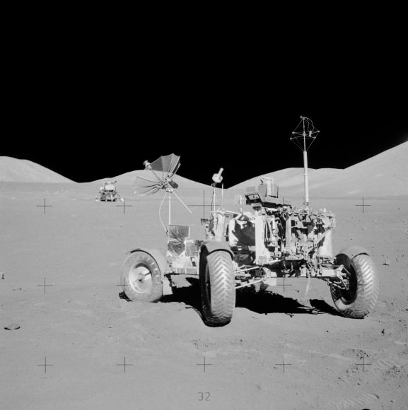
On Thursday, May 16, the long-lived Opportunity drove another 263 feet (80 meters) on Mars – bringing her total odometry since landing on 24 January 2004 to 22.220 miles (35.760 kilometers) – and broke through the 40 year old driving record set back in December 1972 by Apollo 17 astronauts Eugene Cernan and Harrison Schmitt.
See below our complete map of the 9 Year Journey of Opportunity on Mars.
Cernan and Schmitt visited Earth’s moon on America’s final lunar landing mission and drove their mission’s Lunar Roving Vehicle (LRV-3) 22.210 miles (35.744 kilometers) over the course of three days on the moon’s surface at Taurus-Littrow.
Apollo 17 lunar rover at final resting place on the Moon. Lunar module in the background. Credit: NASA
Cernan was ecstatic at the prospect of the Apollo 17 record finally being surpassed.
“The record we established with a roving vehicle was made to be broken, and I’m excited and proud to be able to pass the torch to Opportunity, ” said Cernan to team member Jim Rice of NASA Goddard Space Flight Center, Greenbelt, Md, in a NASA statement.
And Opportunity still has plenty of juice left!
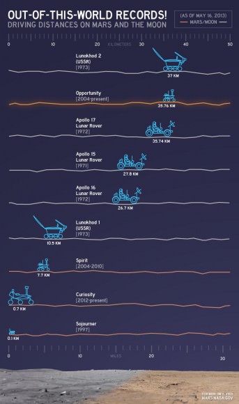
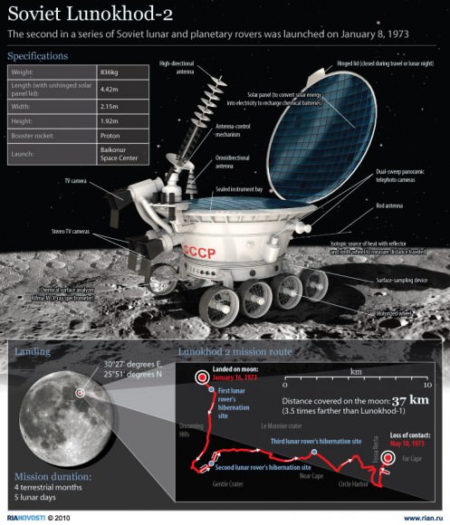
So, although there are no guarantees, one can reasonably expect the phenomenal Opportunity robot to easily eclipse the ‘Solar System World Record’ for driving distance on another world that is currently held by the Soviet Union’s remote-controlled Lunokhod 2 rover. See detailed graphic below.
In 1973, Lunokhod 2 traveled 23 miles (37 kilometers) on the surface of Earth’s nearest neighbor.
Why could Opportunity continue farther into record setting territory ?
Because Opportunity’s handlers back on Earth have dispatched the Martian robot on an epic trek to continue blazing a path forward around the eroded rim of the huge crater named ‘Endeavour’ – where she has been conducting ground breaking science since arriving at the “Cape York” rim segment in mid 2011.
Out-of-this-World Records. This chart illustrates comparisons among the distances driven by various wheeled vehicles on the surface of Earth’s moon and Mars. Of the vehicles shown, the NASA Mars rovers Opportunity and Curiosity are still active and the totals for those two are distances driven as of May 15, 2013. Opportunity set the new NASA driving record on May 15, 2013 by traveling 22.220 miles (35.760 kilometers). The international record for driving distance on another world is still held by the Soviet Union’s remote-controlled Lunokhod 2 rover, which traveled 23 miles (37 kilometers) on the surface of Earth’s moon in 1973. Credit: NASA/JPL-Caltech
Opportunity has just now set sail for her next crater rim destination named “Solander Point”, an area about 1.4 miles (2.2 kilometers) away – due south from “Cape York.”
Endeavour Crater is 14 miles (22 km) wide, featuring terrain with older rocks than previously inspected and unlike anything studied before. It’s a place no one ever dared dream of reaching prior to Opportunity’s launch in the summer of 2003 and landing on the Meridiani Planum region in 2004.
Opportunity will blast through the world record milestone held by the Lunokhod 2 rover somewhere along the path to “Solander Point.”
Thereafter Opportunity will rack up ever more miles as the rover continues driving further south to a spot called “Cape Tribulation”, that is believed to hold caches of clay minerals that formed eons ego when liquid water flowed across this region of the Red Planet.
It’s a miracle that Opportunity has lasted so far beyond her design lifetime – 37 times longer than the 3 month “warranty.”
“Regarding achieving nine years, I never thought we’d achieve nine months!” Principal Investigator Prof. Steve Squyres of Cornell University told me recently on the occasion of the rovers 9th anniversary on Mars in January 2013.
“Our next destination will be Solander Point,” said Squyres.
Opportunity was joined on Mars by her younger sister Curiosity, currently exploring the crater floor inside Gale Crater since landing on Aug. 6, 2012.
Curiosity is likewise embarked on a epic trek – towards 3 mile high (5.5 km) Mount Sharp some 6 miles away.
Both rovers Opportunity & Curiosity have discovered phyllosilicates, hydrated calcium sulfate mineral veins and vast evidence for flowing liquid water on Mars. All this data enhances the prospects that Mars could have once supported microbial life forms.
The Quest for Life beyond Earth continues ably with NASA’s Martian sister rovers.
And don’t forget to “Send Your Name to Mars” aboard NASA’s MAVEN orbiter- details here. Deadline: July 1, 2013
Traverse Map for NASA’s Opportunity rover from 2004 to 2013 to Record Setting Drive on May 15. This map shows the entire path the rover has driven during more than 9 years and over 3309 Sols, or Martian days, since landing inside Eagle Crater on Jan 24, 2004 to current location heading south from Cape York ridge at the western rim of Endeavour Crater. On May 15, 2013 Opportunity drove 263 feet (80 meters) southward – achieving a total traverse distance on Mars of 22.22 miles (35.76 kilometers) – and broke the driving record by any NASA vehicle that was previously held by the astronaut-driven Apollo 17 Lunar Rover in 1972.
Credit: NASA/JPL/Cornell/ASU/Marco Di Lorenzo/Ken KremerView Back at Record-Setting Drive by Opportunity. On the 3,309th Martian day, or sol, of its mission on Mars (May 15, 2013) NASA’s Mars Exploration Rover Opportunity drove 263 feet (80 meters) southward along the western rim of Endeavour Crater. That drive put the total distance driven by Opportunity since the rover’s January 2004 landing on Mars at 22.220 miles (35.760 kilometers. This exceeded the distance record by any NASA vehicle, previously held by the astronaut-driven Apollo 17 Lunar Rover in 1972. Credit: NASA/JPL-CaltechSoviet Lunokhod-2 lunar rover. Credit: Ria Novosti


![MER10-SpiritAndOpportunity_ByTheNumbers[1]](https://www.universetoday.com/wp-content/uploads/2014/01/MER10-SpiritAndOpportunity_ByTheNumbers1.jpg)