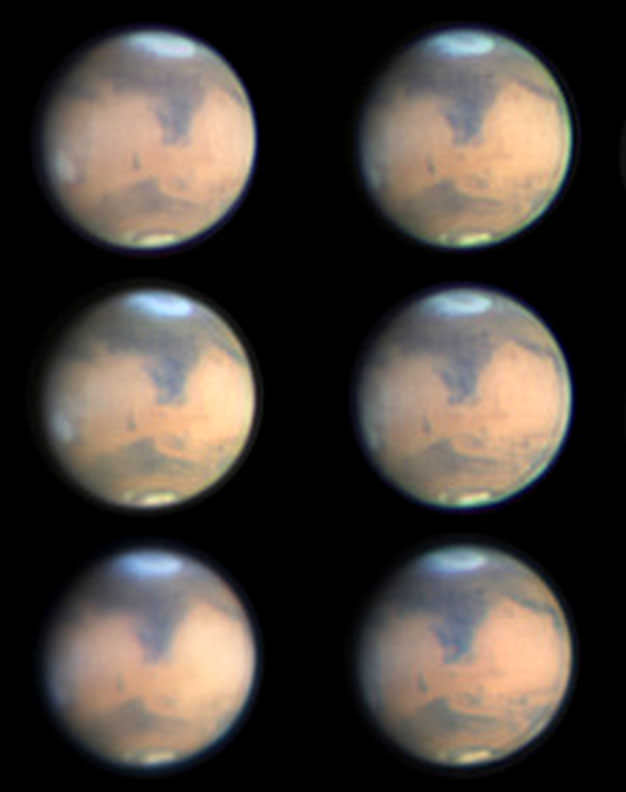
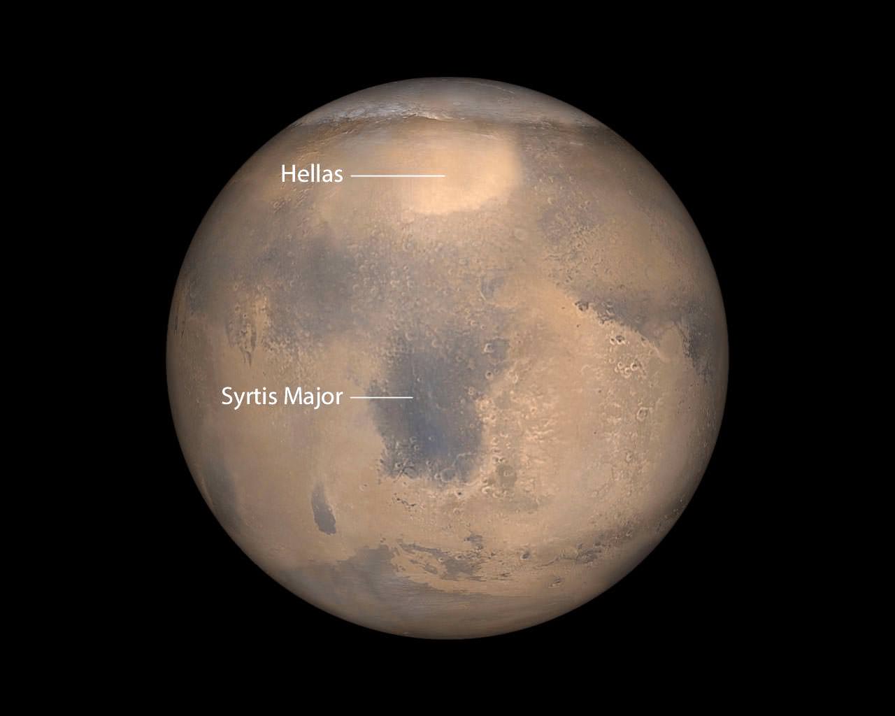
Mars photographed during part of its rotation from Melbourne, Australia on March 8. The bright "cap" marks Hellas, now covered in wintertime frost and clouds. Credit: Maurice Valimberti
Earth’s changing weather always makes life interesting. Seeing weather on other planets through a telescope we sense a kinship between our own volatile world and the fluttering image in the eyepiece. With the April 8 opposition of Mars rapidly approaching, you won’t want to miss a striking meteorological happening right now on the Red Planet.
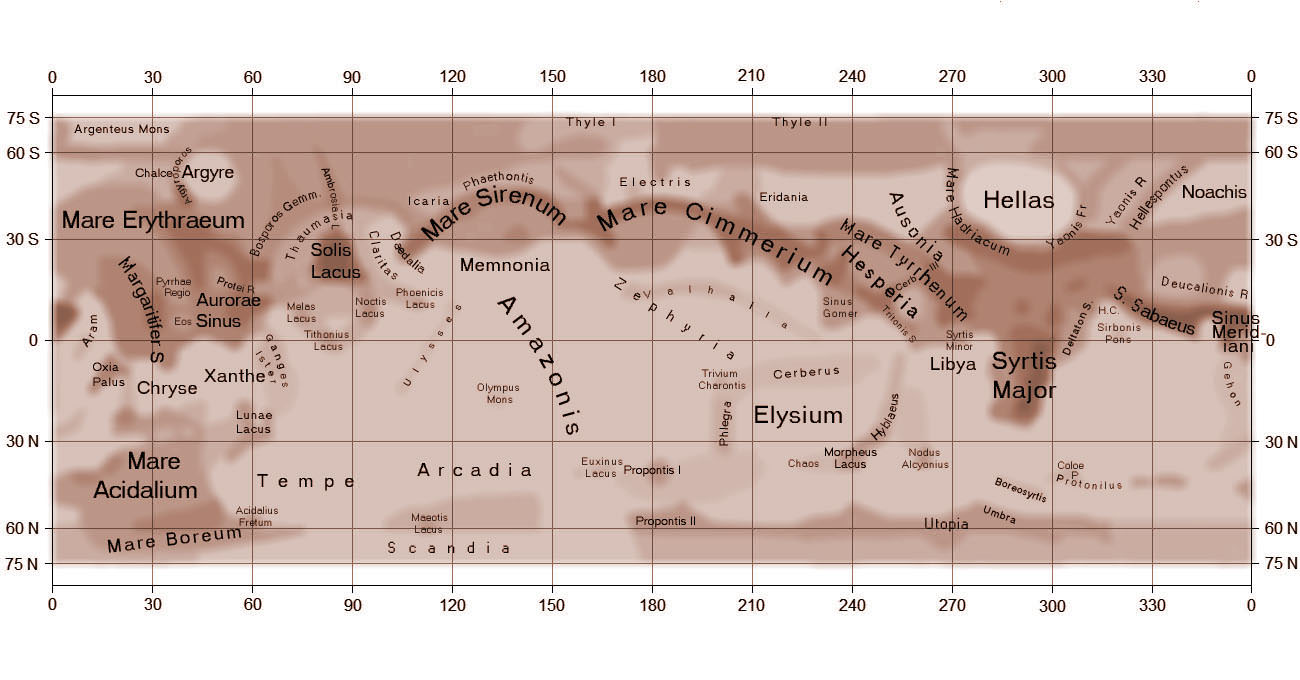
Map showing the most prominent dark features on Mars. Hellas is at upper right. Credit: A.L.P.O.
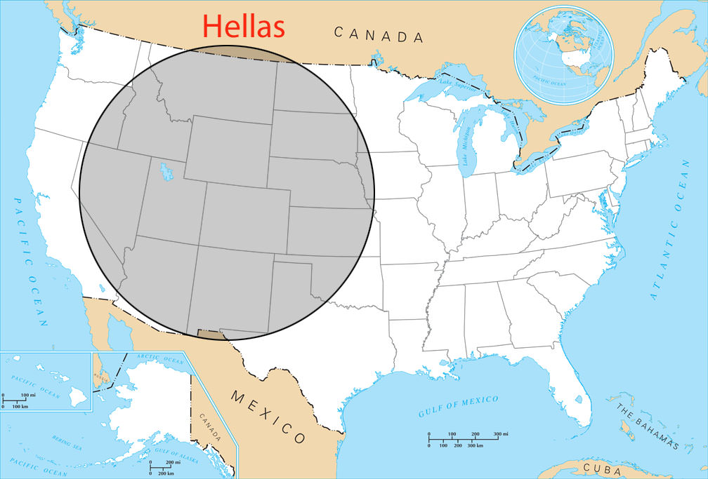
Winter’s already well underway in the planet’s southern hemisphere and there’s no better place to see it than over Hellas, Mars’ biggest impact crater. Hellas formed some 4 billion years when a small asteroid crashed into the young planet and left a scar measuring 1,400 miles (2,300 km) wide and 26,465 feet (7,152 meters) deep. Point your telescope in its direction in the next few weeks and you’ll see what looks at first like the planet’s south polar cap. Don’t be deceived. That’s Hellas coated in dry ice frost and filled with wintertime clouds.
The Hellas impact basin, also known as Hellas Planitia, is 1,400 miles wide. After Mars’ Utopia Planitia and the moon’s South Pole-Aitken Basin, Hellas is the third largest confirmed crater in the solar system.
Right now, Mars’ northern hemisphere, along with the north polar cap, are tipped our way. Though the cap is rapidly vaporizing as the northern summer progresses, you can still spot it this month as a small dab of white along the northern limb in 6-inch (15 cm) and larger telescopes. Use a magnification upwards of 150x for the best views. The south polar cap can’t be seen because it’s tipped beyond the southern limb.
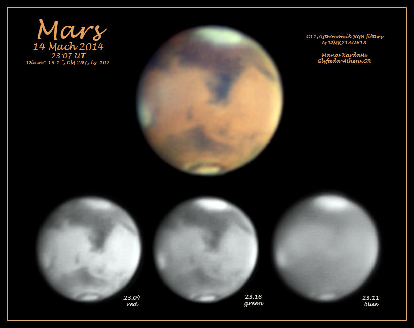
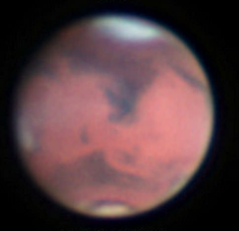
Mars from Athens, Greece on March 14, 2014 with Hellas (top), Syrtis Major and both morning and evening limb water clouds. The winter-whitened Hellas impact basin is best seen using magnifications of 150x or higher. Credit: Manos Kardasis
Along with nearby Syrtis Major, Hellas was one of the first features discovered with the telescope. Even in summer its pale floor stands out against the darker volcanic features of the planet. Though windswept and bitter cold now, Hellas’ great depth makes it one of the warmest places on Mars during the summer months. Mid-summer atmospheric pressure has been measured at more than 10 millibars, more than twice the planet’s mean. Afternoon high temperatures reach near the freezing point (32 F / 0 C) with nighttime lows around -50 F (-45 C). Winter temperatures are much more severe with lows around -22o F (-140 C). Carbon dioxide condenses as frost and whitens the floors of many craters during this time.
Mars photographed by the Mars Global Surveyor shows the equally prominent Syrtis Major and the Hellas impact basin. Syrtis Major is an ancient, low relief shield volcano. Credit; NASA/JPL/Malin Space Systems
We can only see Hellas when that hemisphere is turned in our direction; this happens for about a week and a half approximately once a month. European observers are favored this week with Hellas well placed near the planet’s central meridian from 1 – 4 a.m. local time. Why the outrageous hour? Mars rises around 10 p.m. but typically looks soft and mushy in the telescope until it’s high enough to clear the worst of atmospheric turbulence 2 – 3 hours later. North and South American observers will get their turn starting this Saturday March 22nd around 12:30 – 1 a.m. Good Hellas viewing continues through early April.
Mars at 1 a.m. CDT on successive nights starting March 21, 2014. Notice how planetary features appear to rotate slowly eastward night to night. Created with images from Meridian
Like Earth, Mars revolves from west to east on its axis, but because it rotation period is 37 minutes longer than Earth’s, Hellas and all Martian features appear to drift slowly eastward with each succeeding night. A feature you observed face-on at midnight one night will require staying up until 2:30 a.m. a week later for Mars to “rotate it back” to the same spot. To keep track of the best times to look for Hellas or anything else on Mars, I highly recommend the simple, free utility called Meridian created by Claude Duplessis. Set your time zone and you’ll know exactly the best time to look.
Mars on March 8, 2014 shows clouds over Hellas and evening limb clouds. Credit: Chin Wei Loon
While you’re out watching the Martian winter at work, don’t forget to also look for the shrinking north polar cap and bright, patchy clouds along the planet’s morning (east) and evening limbs. You can use the map above to try and identify the many subtle, gray-toned features named after lands in classic antiquity by 19th century Italian astronomer and Mars aficionado Giovanni Schiaparelli.
I will you success in seeing Hellas and encourage you to share your observations with us here at Universe Today.
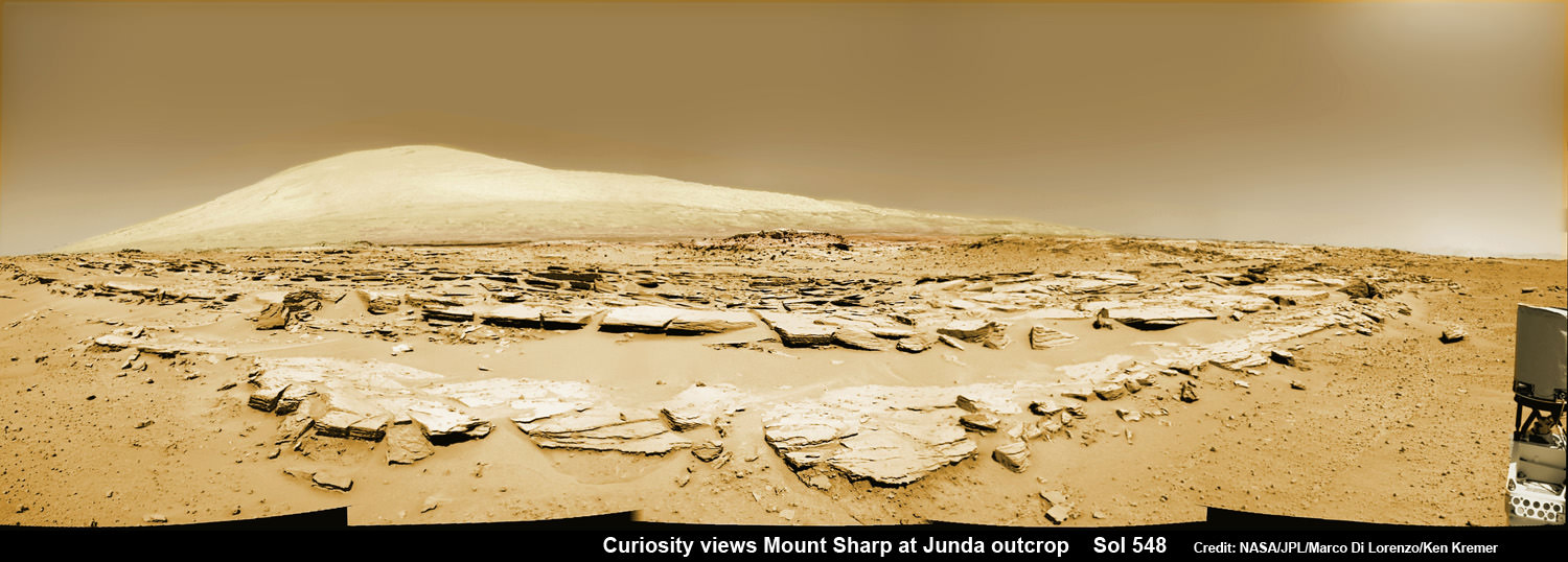
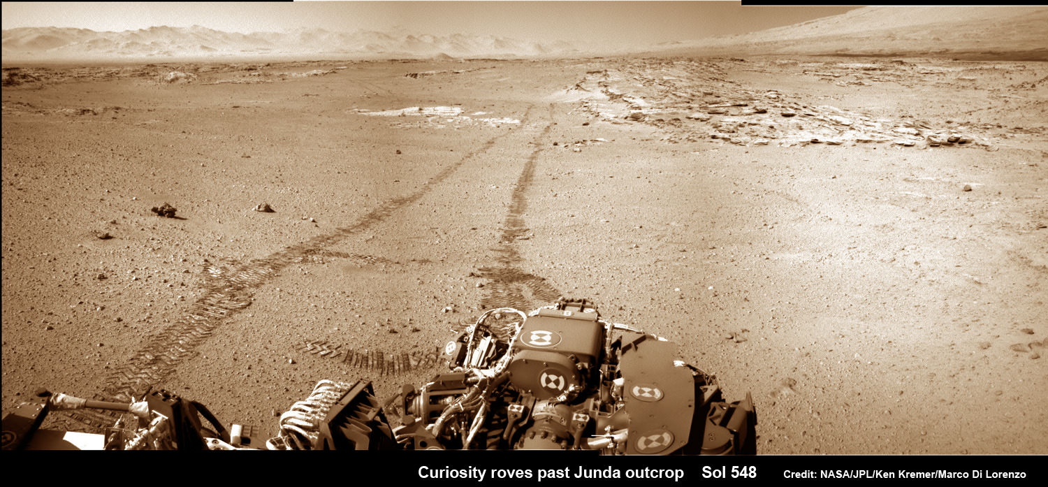
Mars rock rows and Mount Sharp. Martian landscape scene with rows of striated rocks in the foreground and Mount Sharp on the horizon. NASA's Curiosity Mars rover paused mid drive at the Junda outcrop to snap the component images for this navcam camera photomosaic on Sol 548 (Feb. 19, 2014) and then continued traveling southwards towards mountain base. UHF Antenna at right. Credit: NASA/JPL-Caltech/Marco Di Lorenzo/Ken Kremer-kenkremer.com
Mars rock rows and Spectacular Mount Sharp
Martian landscape scene with rows of striated rocks in the foreground and spectacular Mount Sharp on the horizon. NASA’s Curiosity Mars rover paused mid drive at the Junda outcrop to snap the component images for this colorized navcam camera photomosaic on Sol 548 (Feb. 19, 2014) and then continued traveling southwards towards mountain base. UHF Antenna at right.
Credit: NASA/JPL-Caltech/Marco Di Lorenzo/Ken Kremer-kenkremer.com
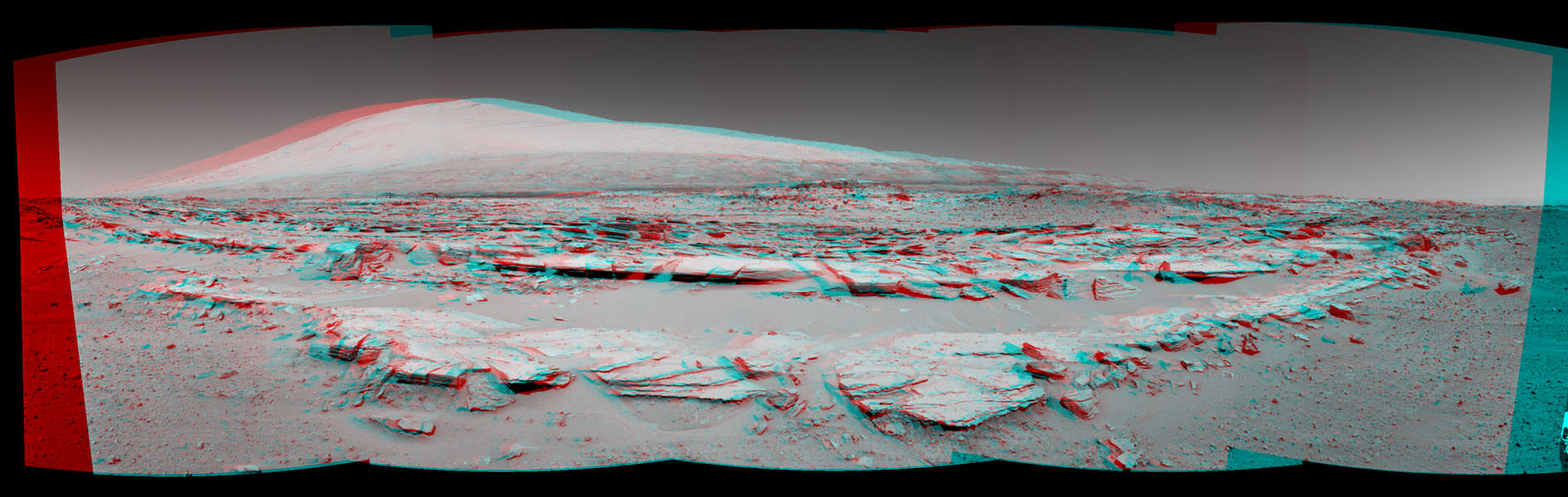
See stereo 3-D and look back views below[/caption]
Like any good tourist, NASA’s rover Curiosity apparently couldn’t resist the photobug urge from a gorgeous Martian mountain scene she happened by recently and decided to pull over and enjoy the view.
So she stopped the dune buggy mid-drive on the sandy road to her daily destination one Sol last week on Feb. 19, powered up the camera suite and excitedly snapped a spectacular landscape view of a striated rock field dramatically back dropped by towering Mount Sharp on the horizon.
See our Mars rocks and Mount Sharp photomosaic above and a 3-D stereoscopic view from NASA below.
The sedimentary foothills of Mount Sharp, which reaches 3.4 miles (5.5 km) into the Martian sky, is the 1 ton robots ultimate destination inside Gale Crater because it holds caches of water altered minerals.
Martian Landscape With Rock Rows and Mount Sharp (Stereo) This stereo landscape scene from NASA’s Curiosity Mars rover on Feb. 19, 2014 shows rows of rocks in the foreground and Mount Sharp on the horizon. It appears three dimensional when viewed through red-blue glasses with the red lens on the left. Credit: NASA/JPL-Caltech
And just for good measure, Curiosity also snapped a series of breathtaking look back photos showing her tracks in the dune filled terrain from whence she came since straddling through the Dingo Gap gateway. See our mosaics below.
The panoramic mountain view taken on Sol 548 shows rows of striated rocks all oriented in a similar direction in the foreground with Mount Sharp in the background.
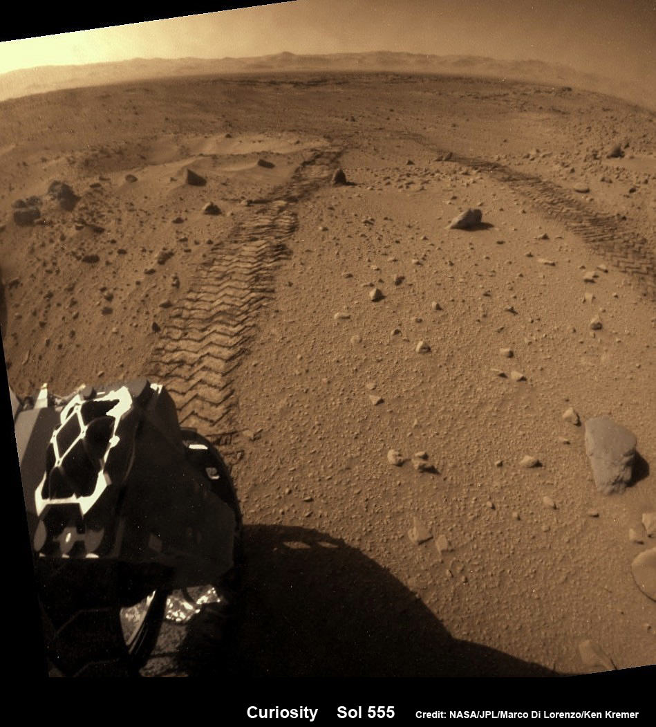
Curiosity looks back across dune field to her wheel tracks and a small crater she just missed. Flattened rear hazcam image, colorized from Sol 555 (Feb 27, 2014). Credit: NASA/JPL-Caltech/Marco Di Lorenzo/Ken Kremer-kenkremer.com
Scientists directed Curiosity to drive by the rock rows nicknamed “Junda” after their interest was piqued by orbital images taken by the powerful telescopic camera on NASA’s Mars Reconnaissance Orbiter (MRO) circling overhead.
The six wheeled rover paused during the planned Feb. 19 drive of 328 feet (100 meters) to capture the imagery.
She then pushed forward to finish the day’s drive and snapped another fabulous look back view – see our mosaic below.
And the next day on Feb. 20 (Sol 549), she also completed her second 100 meter drive in reverse.
Her handlers are occasionally commanding Curiosity to drive backwards in a newly tested bid to minimize serious damage to the six 20 inch diameter wheels in the form of rips and tears caused by rough edged Red Planet rocks – see our wheel mosaic below.
Curiosity looks back at Martian sand dunes and rover tracks after passing by Junda outcrop (right) on Sol 548 (Feb. 19, 2014) with Gale Crater rim and Mount Sharp on the distant horizon. Navcam colorized photomosaic. Credit: NASA/JPL-Caltech/Ken Kremer- kenkremer.com/Marco Di Lorenzo
Curiosity is well on the way to her next near term goal, which is a science waypoint, named Kimberly (formerly called KMS-9), which lies about half a mile ahead.
Kimberly is of interest to the science team because it sits at an the intersection of different rock layers and also features ground with striations like those at “Junda”.
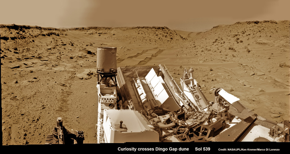
Curiosity looks back eastward to ‘Dingo Gap’ sand dune inside Gale Crater. After crossing over the 3 foot (1 meter) tall dune on Sol 539, Feb. 9, 2014 the rover drove westward into the ‘Moonlight Valley’. The parallel rover wheel tracks are 9 feet (2.7 meters) apart. Assembled from Sol 539 colorized navcam raw images. Credit: NASA/JPL/ Ken Kremer- kenkremer.com/Marco Di Lorenzo
So, after the rover reaches Kimberly, researchers plan to temporarily halt driving for awhile to investigate the location and direct the robot to drill into another rock to collect samples for analysis by the two state- of-the -art chemistry labs.
If drilling is warranted, Kimberly would be the site of Curiosity’s first drilling operation since the Cumberland outcrop target was bored into during the spring of 2013 at Yellowknife Bay.
Curiosity departed the Yellowknife Bay region in July 2013 where she discovered a habitable zone and thereby accomplished the primary goal of the mission.
To date Curiosity’s odometer stands at 5.3 kilometers and she has taken over 125,000 images.
The robot has somewhat less than another 5 km to go to reach the base of Mount Sharp.
She perhaps may arrive sometime in mid 2014.
Arrival time at Mount Sharp depends on driving speed and whether the upcoming terrain is smoother or strewn with sharp edged rocks that have hindered progress due to accumulating wear and tear on the aluminum wheels.
Up close photomosaic view shows lengthy tear in rover Curiosity’s left front wheel caused by recent driving over sharp edged Martian rocks on the months long trek to Mount Sharp. Raw images taken by the MAHLI camera on Curiosity’s arm on Jan. 31, 2014 (Sol 529) were assembled to show some recent damage to several of its six wheels Credit: NASA / JPL / MSSS / Marco Di Lorenzo / Ken Kremer- kenkremer.com See below complete 6 wheel mosaic and further wheel mosaics for comparison
Stay tuned here for Ken’s continuing Curiosity, Opportunity, Chang’e-3, GPM, SpaceX, Orbital Sciences, LADEE, MAVEN, MOM, Mars and more planetary and human spaceflight news. Learn more at Ken’s upcoming presentations at the NEAF convention on April 12/13.
Curiosity’s View Past Tall Dune at edge of ‘Dingo Gap’
This photomosaic from Curiosity’s Navigation Camera (Navcam) taken at the edge of the entrance to the Dingo Gap shows a 3 foot (1 meter) tall dune and valley terrain beyond to the west, all dramatically back dropped by eroded rim of Gale Crater. View from the rover’s current position on Sol 528 (Jan. 30, 2014). The rover team may decide soon whether Curiosity will bridge the dune gap as a smoother path to next science destination. Credit: NASA/JPL-Caltech/Marco Di Lorenzo/Ken Kremer- kenkremer.com
We’ve all seen charts showing the relative sizes of planets and moons compared to each other, which are cool to look at but don’t really give a sense of the comparative masses of the various worlds in our Solar System. It’s one thing to say the Earth is four times larger than the Moon, it’s entirely another to realize it’s 87 times more massive!
That’s where this new animation from astrophysicist Rhys Taylor comes in nicely.
The latest out-of-the-box idea to help address funding shortages for researchers, scientists, educators and students goes to Mars. Uwingu has launched an update to their web site with a new project that gives people the opportunity to name over 550,000 craters on Mars. The company hopes to raise over $10M for helping to fund space science and education.
“If we’re successful, it’ll by far be the largest such private sector grant fund in history,” said scientist and Uwingu CEO Alan Stern.
Starting today, the public can get involved in Mars exploration by helping to create Uwingu’s new Mars map, with names for all the approximately 550,000 unnamed, scientifically cataloged craters on Mars.
Just like how Apollo astronauts have named landing site landmarks during their Moon missions or how Mars scientists name features they encounter on robotic missions, Uwingu says, “Now it’s your turn.”
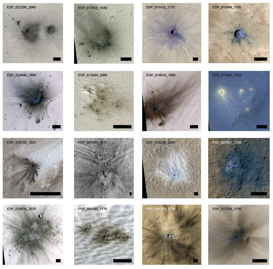
Examples of craters various craters on Mars. Credit: NASA/JPL/Univ. of Arizona.
Not only are there craters to name, but you can also help name the map grid rectangles of all the Districts and Provinces in Uwingu’s “address system” – which they say is the first ever address system for Mars.
Prices for naming craters vary, depending on the size of the crater, and begin at $5 dollars. For each crater you purchase and name, Uwingu gives you a shareable Web link and a naming certificate.
Stern told Universe Today that he doesn’t think they’ll have any issues with the IAU over this latest venture.
“We’re not going to be stamping names on their maps,” Stern said via phone. “We’re just opening up a public feature naming for the first time. We don’t think we own it, we don’t think anyone owns it. We’re just creating a new application.”
Stern added that in 50 years of Mars exploration, only about 15,000 features have been named. “There are 550,000 craters alone that are begging for names,” and hinted that Uwingu will have opportunities to name other Martian features in the future.
Stern and the rest of the Uwingu team – which includes space notables such as space historian and author Andrew Chaikin, planet hunter Dr. Geoff Marcy, planetary scientist and CEO of the Planetary Science Institute, Dr. Mark Sykes, former Executive Director of the Planetary Society Dr. Louis Friedman, and author Dr. David Grinspoon — know that the names likely won’t officially be approved by the IAU, but said they will be similar to the names given to features on Mars by the mission science teams (such as Mt. Sharp on Mars –the IAU-approved name is Aeolis Mons) or even like Pike’s Peak, a mountain in Colorado which was named by the public, in a way, as early settlers started calling it that, and it soon became the only name people recognized.
“Mars scientists and Apollo astronauts have named features on the Red Planet and the Moon without asking for the IAU’s permission,” Stern said. In the past, Stern has said that he realizes having people pay to suggest names for with no official standing may be controversial, and he’s willing to take the chance – and the heat – to try a innovative ways to provide funding in today’s climate of funding cuts.
“We’re trying to do a public good,” he said. “It’s still the case that nobody in this company gets paid. We really want to create a new lane on that funding highway for people who are out of luck due to budget cuts. This is how we’re how we’re trying to change the world for a little better.”
Uwingu’s procedure in the past is that they put half of the money they make into a fund to be given out as grants, and since they are a commercial company, the rest of the money helps pay the their bills.
Curiosity looks back eastward to ‘Dingo Gap’ sand dune inside Gale Crater. After crossing over the 3 foot (1 meter) tall dune on Sol 539, Feb. 9, 2014 the rover drove westward into the ‘Moonlight Valley’. The parallel rover wheel tracks are 9 feet (2.7 meters) apart. Assembled from Sol 539 colorized navcam raw images. Credit: NASA/JPL/ Ken Kremer- kenkremer.com/Marco Di Lorenzo
Curiosity looks back eastward to ‘Dingo Gap’ sand dune inside Gale Crater
After crossing over the 3 foot (1 meter) tall dune on Sol 539, Feb. 9, 2014 the rover drove westward into the ‘Moonlight Valley’. The parallel rover wheel tracks are 9 feet (2.7 meters) apart. Assembled from Sol 539 colorized navcam raw images. Credit: NASA/JPL/ Ken Kremer- kenkremer.com/Marco Di Lorenzo
See Dune and Wheel mosaics below – Story updated [/caption]
The team directing the epic trek of NASA’s Curiosity rover across the floor of Gale Crater has adopted new driving strategies and a new way forward in response to the unexpected wheel damage caused by driving over fields of rough edged Red Planet rocks in recent months.
This week, engineers directed dune buggy Curiosity to drive backwards for a lengthy distance over the Martian surface for the first time since landing.
The SUV sized vehicle apparently passed the reverse driving feasibility test with flying colors and is now well on the way to the exciting journey ahead aiming for the sedimentary layers at the base of towering Mount Sharp – the primary mission destination – which reaches 3.4 miles (5.5 km) into the Martian sky and possesses water altered minerals.
“We wanted to have backwards driving in our validated toolkit because there will be parts of our route that will be more challenging,” said Curiosity Project Manager Jim Erickson of NASA’s Jet Propulsion Laboratory, Pasadena, Calif, in a statement.
On Tuesday, Feb. 18, Curiosity not only drove in reverse, but the 329 feet (100.3 meters) distance covered marked her farthest one-day advance in over three months.
And she is also now roving over the much sought after smoother Martian terrain, as hoped, when the team decided to alter the traverse route based on high resolution imaging observations collected by the telescopic camera on NASA’s Mars Reconnaissance Orbiter (MRO) circling overhead.
The goal is to minimize wear and tear on the 20 inch diameter wheels.
This map shows the route driven and route planned for NASA’s Curiosity Mars rover from before reaching “Dingo Gap” — in upper right — to the mission’s next science waypoint, “Kimberley” (formerly referred to as “KMS-9”) — in lower left. Credit: NASA/JPL-Caltech/Univ. of Arizona
Engineers were forced to devise new driving techniques and consider a new route forward after the aluminum wheels accumulated significant punctures and rips during the past few months of driving over fields strewn with sharp edged Martian rocks.
“We have changed our focus to look at the big picture for getting to the slopes of Mount Sharp, assessing different potential routes and different entry points to the destination area,” Erickson said.
“No route will be perfect; we need to figure out the best of the imperfect ones.”
But to reach the smooth terrain and the science rich targets located on the pathway ahead, the six wheeled rover first had to pass through a gateway known as the ‘Dingo Gap’ sand dune.
Curiosity’s View Past Tall Dune at edge of ‘Dingo Gap’
This photomosaic from Curiosity’s Navigation Camera (Navcam) taken at the edge of the entrance to the Dingo Gap shows a 3 foot (1 meter) tall dune and valley terrain beyond to the west, all dramatically back dropped by eroded rim of Gale Crater. View from the rover’s current position on Sol 528 (Jan. 30, 2014). The rover team may decide soon whether Curiosity will bridge the dune gap as a smoother path to next science destination. Credit: NASA/JPL-Caltech/Marco Di Lorenzo/Ken Kremer- kenkremer.com
“Moonlight Valley” is the name of the breathtaking new locale beyond Dingo, Curiosity Principal Investigator John Grotzinger, of Caltech, told Universe Today.
Curiosity crossed through the 3 foot (1 meter) tall Dingo Gap sand dune with ease on Feb. 9 and roved on to targets in the “Moonlight Valley” and the region beyond.
“Moonlight Valley has got lots of veins cutting through it,” Grotzinger told me.
“We’re seeing recessive bedrock.”
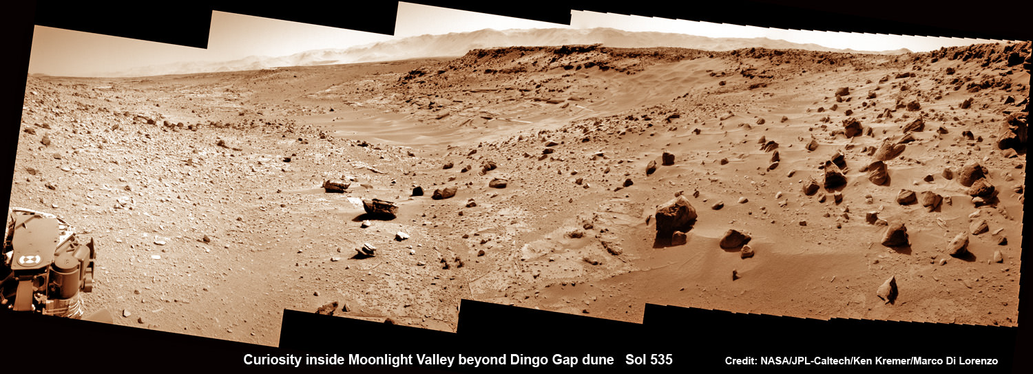
Curiosity scans Moonlight Valley beyond Dingo Gap Dune. Curiosity’s view to “Moonlight Valley” beyond after crossing over ‘Dingo Gap’ sand dune. This photomosaic was taken after Curiosity drove over the 1 meter tall Dingo Gap sand dune and shows dramatic scenery in the valley beyond, back dropped by eroded rim of Gale Crater. Assembled from navigation camera (navcam) raw images from Sol 535 (Feb. 6, 2104) Credit: NASA/JPL-Caltech/Ken Kremer- kenkremer.com/Marco Di Lorenzo
Since passing through the Dingo Gap gateway, Curiosity has traveled another 937 feet (285.5 meters) for a total mission odometry of 3.24 miles (5.21 kilometers) since the nail biting landing on Aug. 6, 2012.
“After we got over the dune, we began driving in terrain that looks like what we expected based on the orbital data. There are fewer sharp rocks, many of them are loose, and in most places there’s a little bit of sand cushioning the vehicle,” Erickson said.
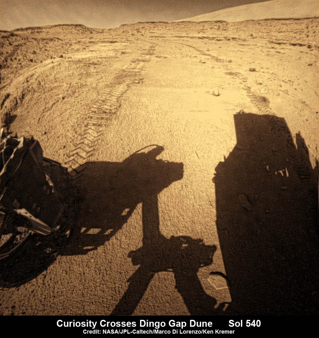
Curiosity looks back to ‘Dingo Gap’ sand dune after crossing over, backdropped by Mount Sharp on Sol 540, Feb. 12, 2014. Rear hazcam fisheye image linearized and colorized. Credit: NASA/JPL/Marco Di Lorenzo/Ken Kremer- kenkremer.com
Curiosity’s near term goal is to reach her next science waypoint, named Kimberly (formerly called KMS-9) which lies about two-thirds of a mile (about 1.1 kilometers) ahead.
Kimberly is of interest to the science team because it sits at an the intersection of different rock layers.
The 1 ton robot may be directed to drill into another rock at Kimberly.
If approved, Kimberly would be her first since drilling operation since boring into Cumberland rock target last spring and since departing the Yellowknife Bay region in July 2013 where she discovered a habitable zone.
Curiosity looks back to ‘Dingo Gap’ sand dune after crossing over, backdropped by Mount Sharp on Sol 535, Feb. 5, 2014. Hazcam fisheye image linearized and colorized. Credit: NASA/JPL/Marco Di Lorenzo/Ken Kremer- kenkremer
To date Curiosity’s odometer stands at 5.2 kilometers and she has taken over 118,000 images. The robot has about another 5 km to go to reach the foothills of Mount Sharp.
Stay tuned here for Ken’s continuing Curiosity, Opportunity, Chang’e-3, SpaceX, Orbital Sciences, LADEE, MAVEN, MOM, Mars and more planetary and human spaceflight news.
Up close photomosaic view shows lengthy tear in rover Curiosity’s left front wheel caused by recent driving over sharp edged Martian rocks on the months long trek to Mount Sharp. Raw images taken by the MAHLI camera on Curiosity’s arm on Jan. 31, 2014 (Sol 529) were assembled to show some recent damage to several of its six wheels Credit: NASA / JPL / MSSS / Marco Di Lorenzo / Ken Kremer- kenkremer.com
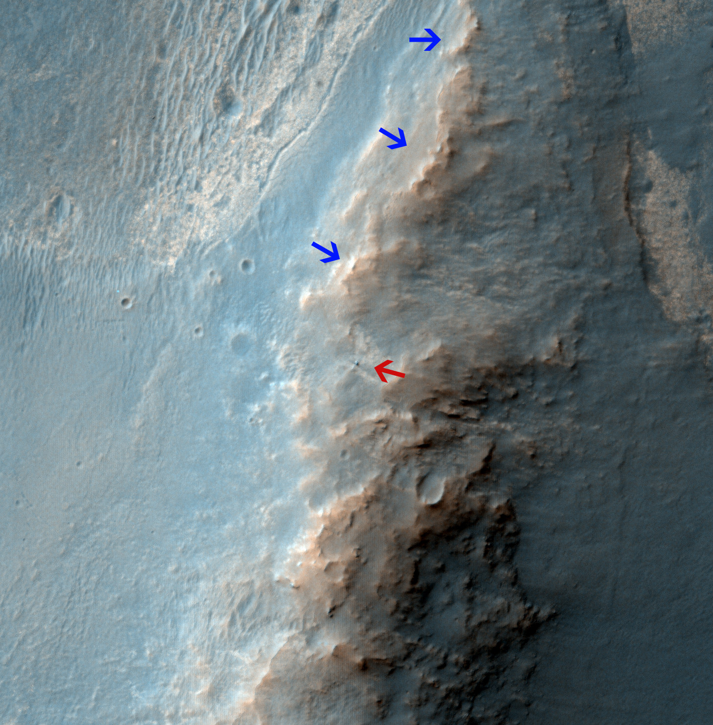
Opportunity Rover on 'Murray Ridge' Seen From Orbit on Valentine’s Day 2014 . The telescopic High Resolution Imaging Science Experiment (HiRISE) camera on NASA's Mars Reconnaissance Orbiter caught this view of NASA's Mars Exploration Rover Opportunity on Feb. 14, 2014 by the summit of Solander Point. The red arrow points to Opportunity at the center of the image. Blue arrows point to tracks left by the rover since it entered the area seen here, in October 2013. The scene covers a patch of ground about one-quarter mile (about 400 meters) wide. North is toward the top. The location is the "Murray Ridge" section of the western rim of Endeavour Crater. Credit: NASA/JPL-Caltech/Univ. of Arizona
Opportunity Rover on ‘Murray Ridge’ Seen From Orbit on Valentine’s Day 2014
The telescopic High Resolution Imaging Science Experiment (HiRISE) camera on NASA’s Mars Reconnaissance Orbiter caught this view of NASA’s Mars Exploration Rover Opportunity on Feb. 14, 2014 by the summit of Solander Point. The red arrow points to Opportunity at the center of the image. Blue arrows point to tracks left by the rover since it entered the area seen here, in October 2013. The scene covers a patch of ground about one-quarter mile (about 400 meters) wide. North is toward the top. The location is the “Murray Ridge” section of the western rim of Endeavour Crater. Credit: NASA/JPL-Caltech/Univ. of Arizona See below corresponding surface view snapped by Opportunity from this location[/caption]
NASA’s renowned Mars rover Opportunity has been spied anew in a fabulous new photo captured just days ago by NASA’s ‘Spy in the Sky’ orbiter circling overhead the Red Planet. See Opportunity from above and below – from today’s location. See orbital view above – just released today.
The highly detailed image was freshly taken on Feb. 14 (Valentine’s Day 2014) by the telescopic High Resolution Imaging Science Experiment (HiRISE) camera on NASA’s Mars Reconnaissance Orbiter (MRO) as the decade old Opportunity was investigating the tasty alien terrain on ‘Murray Ridge’ – nearby the celebrated ‘jelly doughnut’ rock by the summit of Solander Point. See surface views below.
The fabulous orbital image shows not only rover Opportunity at her location today, but also the breathtaking landscape around the robots current location as well as some of the wheel tracks created by the Martian mountaineer as she climbed from the plains below up to near the peak of Solander Point.
The scene is narrowly focused on a spot barely one-quarter mile (400 meters) wide.
Murray Ridge and Solander Point lie at the western rim of a vast crater named Endeavour that spans some 22 kilometers (14 miles) in diameter.
Here is the corresponding Martian surface view snapped by Opportunity on Feb. 16, 2014 (looking back and down to Endeavour crater), while she’s being imaged from Mars orbit on Feb. 14, 2014:
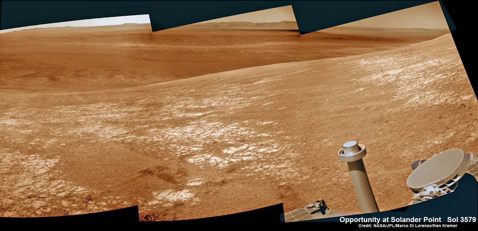
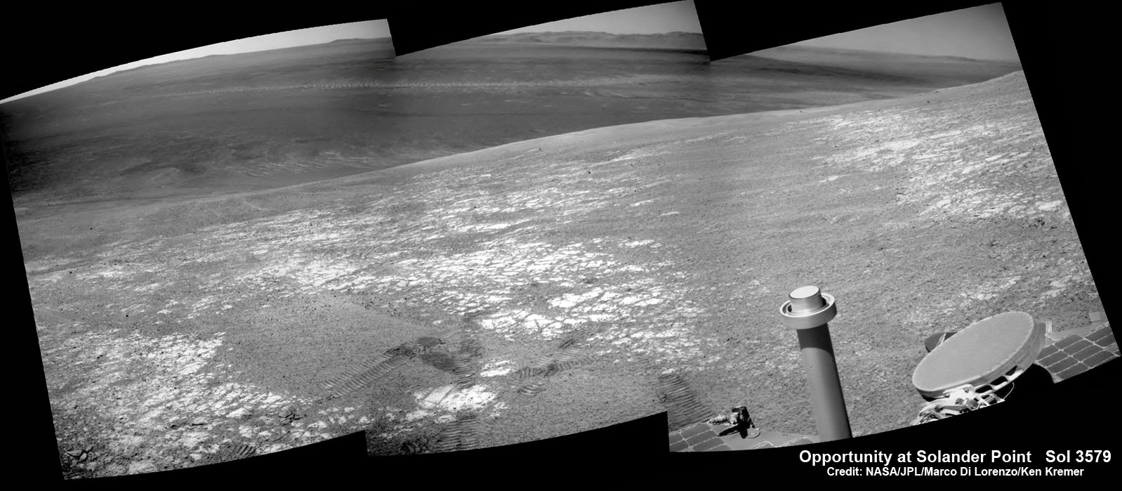
NASA’s Opportunity rover was imaged here from Mars orbit by MRO HiRISE camera on Feb. 14, 2014. This mosaic shows Opportunity’s view today while looking back to vast Endeavour crater from atop Murray Ridge by summit of Solander Point. Opportunity captured this photomosaic view on Feb. 16, 2014 (Sol 3579) from the western rim of Endeavour Crater where she is investigating outcrops of potential clay minerals formed in liquid water. Assembled from Sol 3579 colorized navcam raw images. Credit: NASA/JPL/Cornell/Marco Di Lorenzo/Ken Kremer-kenkremer.com
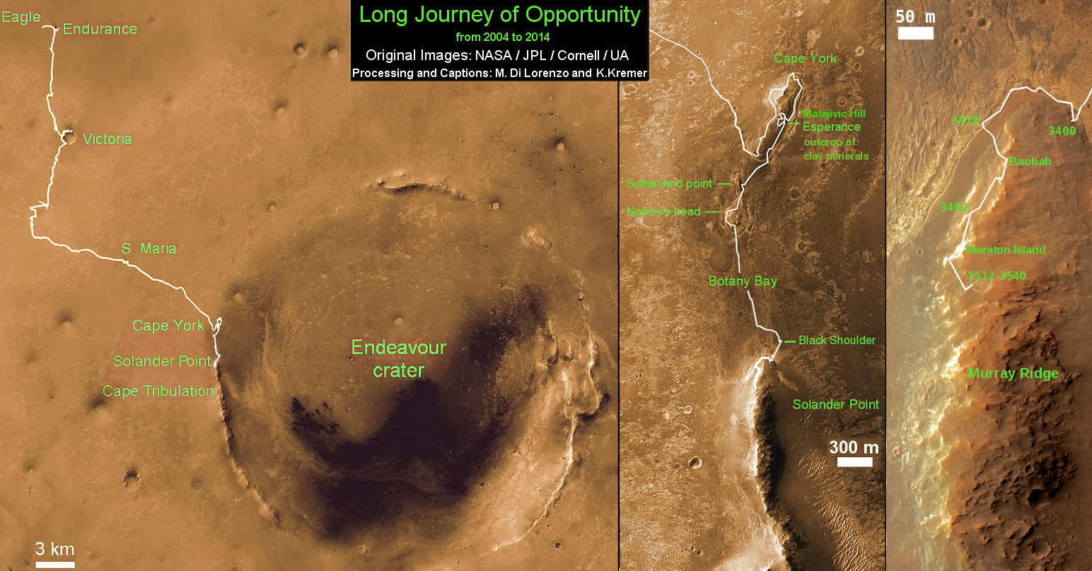
Endeavour is an impact scar created billions of years ago. See our 10 Year Opportunity traverse map below.
And believe it or not, that infamous ‘jelly doughnut’ rock was actually the impetus for this new imaging campaign by NASA’s MRO Martian ‘Spysat.’
To help solve the mystery of the origin of the shiny 1.5 inches wide (4 centimeters) ‘jelly doughnut’ rock, dubbed ‘Pinnacle Island’, the science team decided to enlist the unparalleled capabilities of the HiRISE camera and imaging team in pursuit of answers.
Opportunity by Solander Point peak – 2nd Mars Decade Starts here!
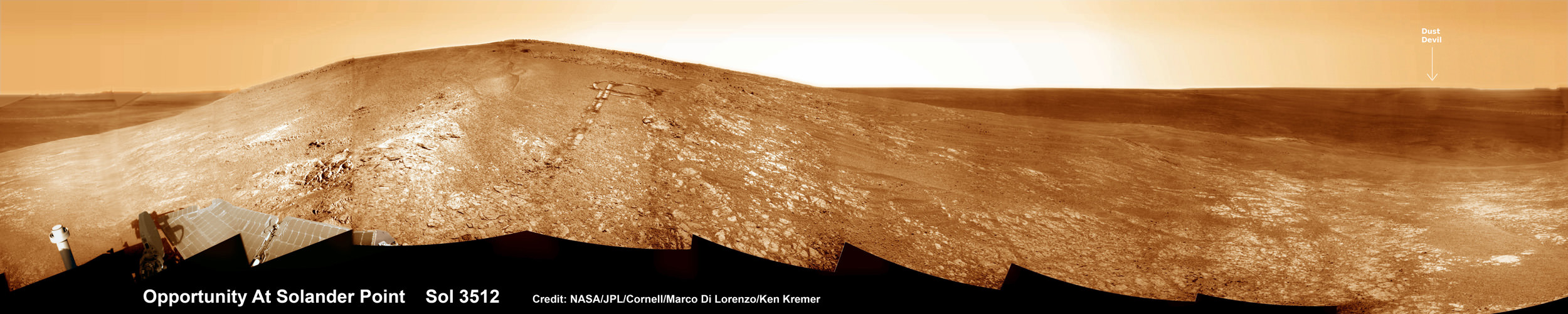
NASA’s Opportunity rover captured this panoramic mosaic on Dec. 10, 2013 (Sol 3512) near the summit of “Solander Point” on the western rim of Endeavour Crater where she starts Decade 2 on the Red Planet. She is currently investigating outcrops of potential clay minerals formed in liquid water on her 1st mountain climbing adventure. Assembled from Sol 3512 navcam raw images. Credit: NASA/JPL/Cornell/Marco Di Lorenzo/Ken Kremer-kenkremer.com
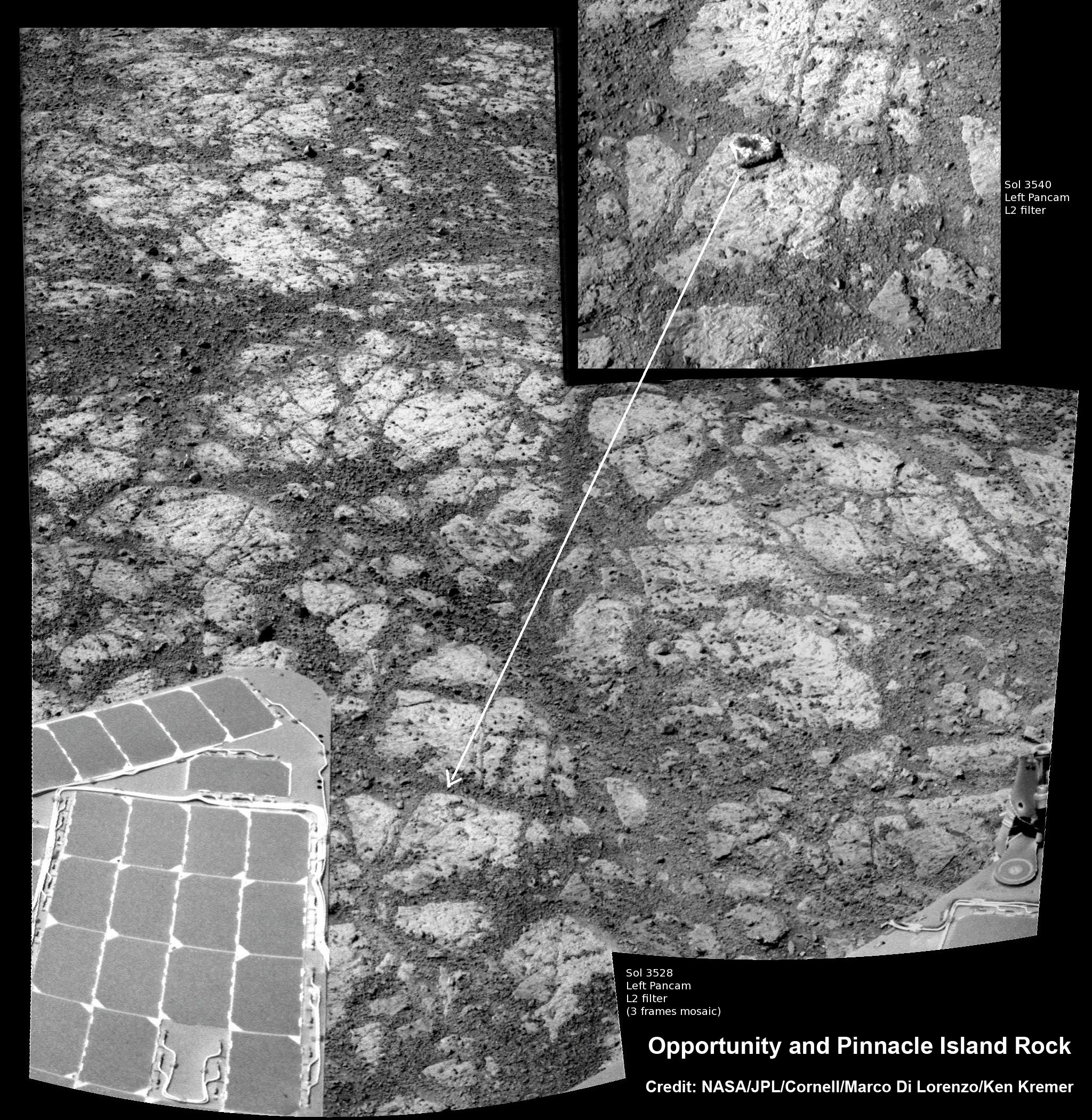
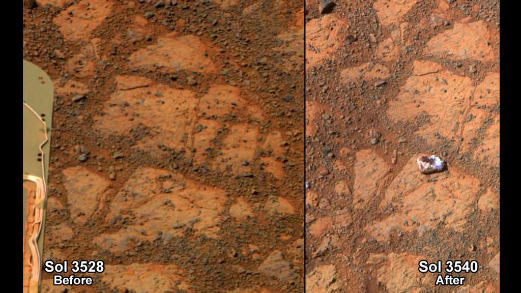
‘Pinnacle Island’ had suddenly appeared out of nowhere in a set of before/after pictures taken by Opportunity’s cameras on Jan, 8, 2014 (Sol 3540), whereas that exact same spot had been vacant of debris in photos taken barely 4 days earlier. And the rover hadn’t budged a single millimeter.
So the HiRISE research team was called in to plan a new high resolution observation of the ‘Murray Ridge’ area and gather clues about the rocky riddle.
The purpose was to “check the remote possibility that a fresh impact by an object from space might have excavated a crater near Opportunity and thrown this rock to its new location”- now known as Pinnacle Island, said NASA in a statement.
Well, no fresh crater impacting site was found in the new image.
“We see no obvious signs of a very recent crater in our image, but a careful comparison to prior images might reveal subtle changes,” wrote HiRISE principal investigator Alfred McEwen in a description today.
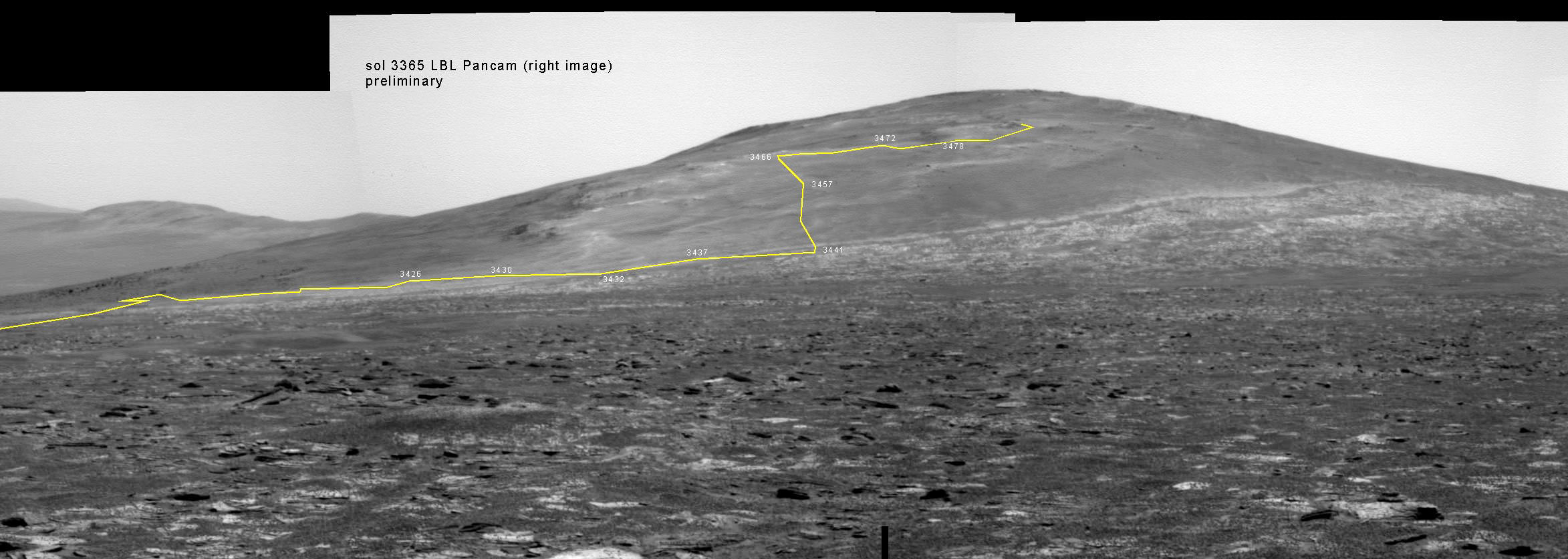
Back on sol 3365 we took this image of Solander Point as we approached it. Here I have plotted the subsequent route that Opportunity has taken in climbing up the ridge. The outcrop shown I the images below are near the end of the yellow traverse line. Caption and mosaic by Larry Crumpler/NASA/JPL/
In the meantime, as I reported here a few days ago the mystery was solved at last by the rover team after Opportunity drove a short distance away from the ‘jelly doughnut’ rock and snapped some ‘look back’ photographs to document the ‘mysterious scene’ for further scrutiny.
It turns out that the six wheeled Opportunity unknowingly ‘created’ the mystery herself when she drove over a larger rock, crushing and breaking it apart with the force from the wheels and her hefty 400 pound (185 kg) mass.
“Once we moved Opportunity a short distance, after inspecting Pinnacle Island, we could see directly uphill an overturned rock that has the same unusual appearance,” said Opportunity Deputy Principal Investigator Ray Arvidson of Washington University in St. Louis, in a NASA statement.
“Murray Ridge” and the Solander Point mountaintop are of great scientific interest because the region is riven with outcrops of minerals, including clay minerals, that likely formed in flowing liquid neutral water conducive to life – potentially a scientific goldmine.
Today, Feb 19, marks Opportunity’s 3582nd Sol or Martian Day roving Mars. She is healthy with plenty of power.
So far she has snapped over 188,800 amazing images on the first overland expedition across the Red Planet.
Her total odometry stands at over 24.07 miles (38.73 kilometers) since touchdown on Jan. 24, 2004 at Meridiani Planum.
Opportunity by Solander Point peak – 2nd Mars Decade Starts here!
NASA’s Opportunity rover captured this panoramic mosaic on Dec. 10, 2013 (Sol 3512) near the summit of “Solander Point” on the western rim of vast Endeavour Crater where she starts Decade 2 on the Red Planet. She is currently investigating summit outcrops of potential clay minerals formed in liquid water on her 1st mountain climbing adventure. See wheel tracks at center and dust devil at right. Assembled from Sol 3512 navcam raw images. Credit: NASA/JPL/Cornell/Marco Di Lorenzo/Ken Kremer-kenkremer.com
Meanwhile on the opposite side of Mars, Opportunity’s younger sister rover Curiosity is trekking towards gigantic Mount Sharp and just crested over the Dingo Gap sand dune. She celebrated 500 Sols on Mars on New Years Day 2014.
Finally, China’s Yutu rover has awoken for her 3rd workday on the Moon.
Stay tuned here for Ken’s continuing Opportunity, Curiosity, Chang’e-3, LADEE, MAVEN, Mars rover, MOM and continuing planetary and human spaceflight news.
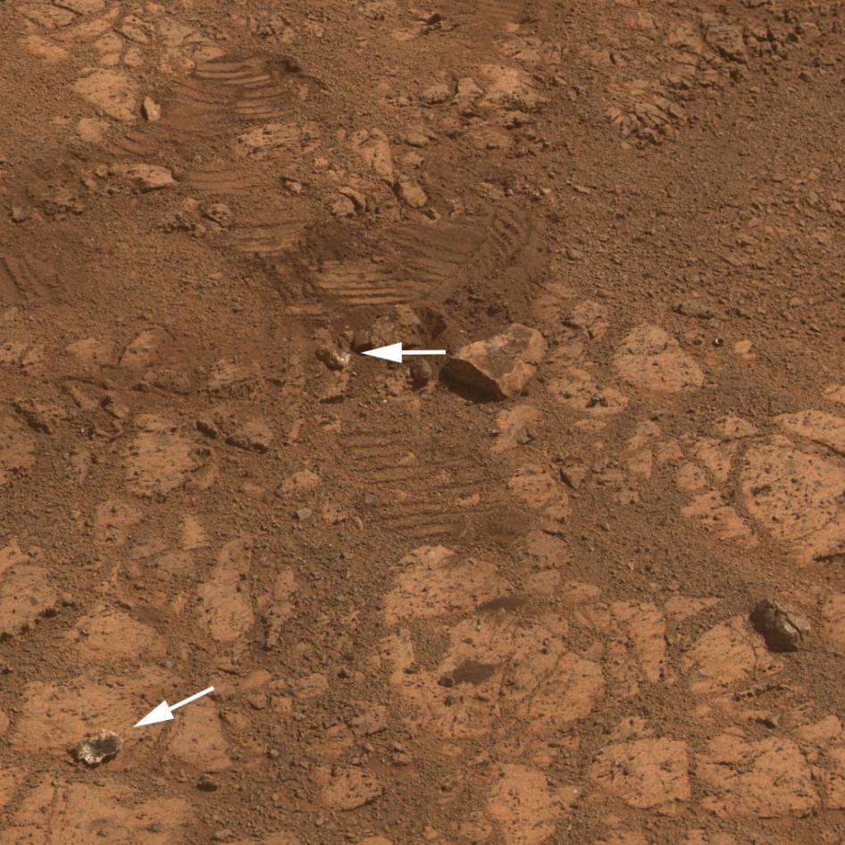
This image from the panoramic camera (Pancam) on NASA’s rover Opportunity shows the location of a rock called “Pinnacle Island” before it appeared in front of the rover in early January 2014. Arrow at lower left. This image was taken during Sol 3567 of Opportunity’s work on Mars (Feb. 4, 2014). Credit: NASA/JPL-Caltech/Cornell Univ./Arizona State Univ.Traverse Map for NASA’s Opportunity rover from 2004 to 2014
This map shows the entire path the rover has driven during a decade on Mars and over 3560 Sols, or Martian days, since landing inside Eagle Crater on Jan 24, 2004 to current location by Solander Point summit at the western rim of Endeavour Crater. Rover will spend 6th winter here atop Solander. Opportunity discovered clay minerals at Esperance – indicative of a habitable zone. Credit: NASA/JPL/Cornell/ASU/Marco Di Lorenzo/Ken Kremer – kenkremer.comNASA’s Opportunity rover was imaged here from Mars orbit by MRO HiRISE camera on Feb. 14, 2014. This mosaic shows Opportunity’s view today while looking back to vast Endeavour crater from atop Murray Ridge by summit of Solander Point. Opportunity captured this photomosaic view on Feb. 16, 2014 (Sol 3579) from the western rim of Endeavour Crater where she is investigating outcrops of potential clay minerals formed in liquid water. Assembled from Sol 3579 navcam raw images. Credit: NASA/JPL/Cornell/Marco Di Lorenzo/Ken Kremer-kenkremer.com
India’s Mars Orbiter Mission (MOM) completes 100 days in space on February 12, 2014 on its journey to reach the Red Planet on Sept 24, 2014. Credit ISRO
India’s maiden Mars explorer, the Mars Orbiter Mission or MOM, celebrated 100 days speeding through space this past week, racing outwards on its historic journey to the Red Planet.
After streaking through space for some ten and a half months, the 1,350 kilogram (2,980 pound) MOM probe will rendezvous with the Red Planet on September 24, 2014 – where she will study the atmosphere and sniff for signals of methane.
Feb. 12, 2014 marked ‘100 Days of MOM’ since the picture perfect blast off on Nov. 5, 2013 from India’s spaceport at the Satish Dhawan Space Centre, Sriharikota, atop the nations indigenous Polar Satellite Launch Vehicle (PSLV) which placed the probe into its initial Earth parking orbit.
First ever image of Earth Taken by Mars Color Camera aboard India’s Mars Orbiter Mission (MOM) spacecraft while orbiting Earth and before the Trans Mars Insertion firing on Dec. 1, 2013. Image is focused on the Indian subcontinent. Credit: ISRO
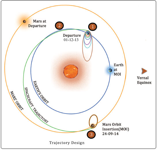
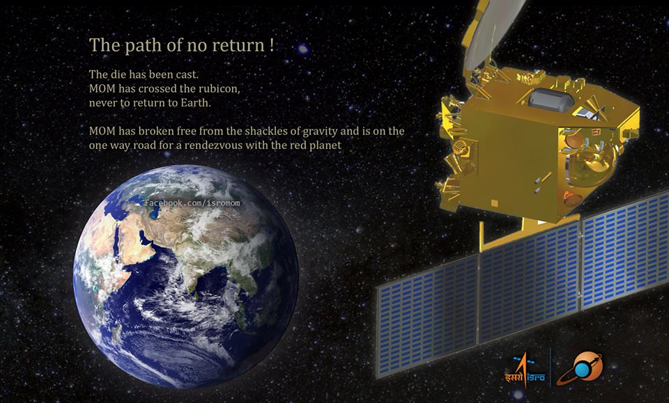
A series of six subsequent orbit raising maneuvers ultimately culminated with the liquid fueled main engine firing on Dec. 1, 2013 for the Trans Mars Injection(TMI) maneuver that successfully placed MOM on a heliocentric elliptical trajectory to the Red Planet.
The TMI, affectionately dubbed ‘The mother of all slingshots’ finally provided the craft with sufficient thrust to achieve escape velocity and blast free of the Earth’s sphere of influence forever and begin her nearly yearlong momentous voyage to Mars.
The first of four in flight Trajectory Correction Maneuvers, TCM-1, was conducted by firing the 22 Newton Thrusters for a duration of 40.5 seconds on December 11, 2013. A trio of additional TCM firings are planned around April 2014, August 2014 and September 2014.
Trans Mars Injection (TMI), carried out on Dec 01, 2013 at 00:49 hrs (IST) has moved the spacecraft in the Mars Transfer Trajectory (MTT). With TMI the Earth orbiting phase of the spacecraft ended and the spacecraft is now on a course to encounter Mars after a journey of about 10 months around the Sun. Credit: ISRO
MOM was designed and developed by the Indian Space Research Organization’s (ISRO) at a cost of $69 Million and marks India’s inaugural foray into interplanetary flight.
During the first 100 days, the probe has traveled about 190 million kilometers and has a little less than 500 million kilometers and 205 days to go during her journey of some 680 million kilometers (400 million miles) overall.
A health check on February 6, 2014 confirmed that the 15 kg (33 lb) science payload comprising five Indian built instruments was turned “ON” and is operating well.
MOM is currently some 16 million km distant from Earth and one way radio signals take approximately 55 seconds.
“The round trip time is almost 2 minutes for a communication signal to go to MOM and come back, about the same time mom takes to make noodles!” ISRO noted humorously in a Facebook mission posting.
“Keep going MOM!”
MOM’s first Trajectory Correction Manoeuver in Baiju Raj’s imagination.
Following the ten month cruise through space the orbital insertion engine will fire for the do or die burn on September 24, 2014 placing MOM into an 377 km x 80,000 km elliptical orbit around Mars.
MOM is not alone in the frigid vacuum of space. She is joined by NASA’s MAVEN orbiter in pursuit of Mars.
MOM will reach Mars vicinity just two days after the arrival MAVEN on Sept. 22, 2014.
To date MAVEN has flown over 137 million miles (221 million km) of its total 442 million miles (712 million km) path to Mars.
If all continues to goes well, India will join an elite club of only four who have launched probes that successfully investigated the Red Planet from orbit or the surface – following the Soviet Union, the United States and the European Space Agency (ESA).
Both MAVEN and MOM’s goal is to study the Martian atmosphere, unlock the mysteries of its current atmosphere and determine how, why and when the atmosphere and liquid water was lost – and how this transformed Mars climate into its cold, desiccated state of today.
Together, MOM and MAVEN will fortify Earth’s invasion fleet at Mars. They join 3 current orbiters from NASA and ESA as well as NASA’s pair of sister surface rovers – Curiosity and Opportunity.
Although they were developed independently and have different suites of scientific instruments, the MAVEN and MOM science teams will “work together” to unlock the secrets of Mars atmosphere and climate history, MAVEN’s top scientist told Universe Today.
“We have had some discussions with their science team, and there are some overlapping objectives,” Bruce Jakosky told me. Jakosky is MAVEN’s principal Investigator from the University of Colorado at Boulder.
“At the point where we [MAVEN and MOM] are both in orbit collecting data we do plan to collaborate and work together with the data jointly,” Jakosky said.
Stay tuned here for Ken’s continuing MOM, Opportunity, Curiosity, Chang’e-3, LADEE, MAVEN, Mars rover and more planetary and human spaceflight news.
This image from the panoramic camera (Pancam) on NASA’s rover Opportunity shows the location of a rock called "Pinnacle Island" before it appeared in front of the rover in early January 2014. Arrow at lower left. This image was taken during Sol 3567 of Opportunity's work on Mars (Feb. 4, 2014). Credit: NASA/JPL-Caltech/Cornell Univ./Arizona State Univ.
The mystery of the world famous “Jelly Doughnut” rock on Mars has at last been solved by diligent mission scientists toiling away in dank research labs on Earth.
The “Jelly Doughnut” rock achieved worldwide fame, or better yet infamy, when it suddenly appeared out of nowhere in pictures taken by NASA’s renowned Red Planet rover Opportunity in January.
And the answer is – well it’s not heretofore undetected Martian beings or even rocks falling from the sky.
Rather its ‘Alien Space Invaders’ – in some sense at least.
And that ‘Alien Space Invader’ is from – Earth! And her name is – Opportunity!
Indeed sister rover Curiosity may have unwittingly pointed to the culprit and helped resolve the riddle when she snapped a brand new photo of Earth – home planet to Opportunity and Curiosity and all their makers! See the evidence for yourselves – lurking here!
It turns out that the six wheeled Opportunity unknowingly ‘created’ the mystery herself when she drove over a larger rock, crushing it with the force from the wheels and her 400 pound (185 kg) mass.
Fragments were sent hurtling across the summit of the north facing Solander Point mountain top, where she is currently climbing up ‘Murray Ridge’ along the western rim of a vast crater named Endeavour that spans some 22 kilometers (14 miles) in diameter. See traverse map below.
One piece unwittingly rolled downhill.
That rock fragment – now dubbed ‘Pinnacle Island’ – suddenly appeared in pictures taken by Opportunity’s cameras on Jan, 8, 2014 (Sol 3540).
Mosaic of Opportunity and mysterious Pinnacle Island rock by Solander Point peak. Mysterious Pinnacle Island rock suddenly appeared out of nowhere in images snapped on Sol 3540. It was absent in earlier images on Sol 3528. This mosaic shows the rock nearby the solar panels of NASA’s Opportunity rover. Assembled from Sol 3528 and 3540 pancam raw images. Credit: NASA/JPL/Cornell/Marco Di Lorenzo/Ken Kremer-kenkremer.com
And that exact same spot had been vacant of debris in photos taken barely 4 days earlier – during which time the rover didn’t move a single millimeter.
Pinnacle Island measures only about 1.5 inches wide (4 centimeters) with a noticeable white rim and red center – hence its jelly doughnut nickname.
The Martian riddle was finally resolved when Opportunity roved a tiny stretch and took some look back photographs to document the ‘mysterious scene’ for further scrutiny.
“Once we moved Opportunity a short distance, after inspecting Pinnacle Island, we could see directly uphill an overturned rock that has the same unusual appearance,” said Opportunity Deputy Principal Investigator Ray Arvidson of Washington University in St. Louis, in a NASA statement.
“We drove over it. We can see the track. That’s where Pinnacle Island came from.”
New pictures showed another fragment of the rock – dubbed ‘Stuart Island’ – eerily similar in appearance to the ‘Pinnacle Island’ doughnut.
Opportunity by Solander Point peak – 2nd Mars Decade Starts here! NASA’s Opportunity rover captured this panoramic mosaic on Dec. 10, 2013 (Sol 3512) near the summit of “Solander Point” on the western rim of Endeavour Crater where she starts Decade 2 on the Red Planet. She is currently investigating outcrops of potential clay minerals formed in liquid water on her 1st mountain climbing adventure. Assembled from Sol 3512 navcam raw images. Credit: NASA/JPL/Cornell/Marco Di Lorenzo/Ken Kremer-kenkremer.com
To gather some up-close clues before driving away, the rover deployed its robotic arm to investigate ‘Pinnacle Island’ with her microscopic imager and APXS mineral mapping spectrometer.
The results revealed high levels of the elements manganese and sulfur “suggesting these water-soluble ingredients were concentrated in the rock by the action of water,” says NASA.
“This may have happened just beneath the surface relatively recently,” Arvidson noted, “or it may have happened deeper below ground longer ago and then, by serendipity, erosion stripped away material above it and made it accessible to our wheels.”
This before-and-after pair of images of the same patch of ground in front of NASA’s Mars Exploration Rover Opportunity 13 days apart documents the arrival of a bright rock onto the scene. Credit: NASA/JPL-Caltech/Cornell Univ./Arizona State Univ.
The Solander Point mountaintop is riven with outcrops of minerals, including clay minerals, that likely formed in flowing liquid neutral water conducive to life – potentially a scientific goldmine.
Opportunity is NASA’s 1st ever ‘Decade Old’ living Mars rover.
She has been uncovering and solving Mars’ billion years old secrets for over 10 years now since landing back on January 24, 2004 on Meridiani Planum – although she was only expected to function a mere 90 days!
Today, Feb 15, marks Opportunity’s 3578th Sol or Martian Day roving Mars.
So far she has snapped over 188,700 amazing images on the first overland expedition across the Red Planet.
Her total odometry stands at over 24.07 miles (38.73 kilometers) since touchdown on Jan. 24, 2004 at Meridiani Planum.
Meanwhile on the opposite side of Mars, Opportunity’s younger sister rover Curiosity is trekking towards gigantic Mount Sharp and just crested over the Dingo Gap sand dune. She celebrated 500 Sols on Mars on New Years Day 2014.
Finally, China’s Yutu rover has awoken for her 3rd workday on the Moon.
Stay tuned here for Ken’s continuing Opportunity, Curiosity, Chang’e-3, LADEE, MAVEN, Mars rover, MOM and continuing planetary and human spaceflight news.
Traverse Map for NASA’s Opportunity rover from 2004 to 2014
This map shows the entire path the rover has driven during a decade on Mars and over 3560 Sols, or Martian days, since landing inside Eagle Crater on Jan 24, 2004 to current location by Solander Point summit at the western rim of Endeavour Crater. Rover will spend 6th winter here atop Solander. Opportunity discovered clay minerals at Esperance – indicative of a habitable zone. Credit: NASA/JPL/Cornell/ASU/Marco Di Lorenzo/Ken Kremer – kenkremer.com