It’s time for the Weekly Space Hangout. This is our weekly rundown on all the big space news stories of the week, explained by a dedicated team of space journalists.
Host:Fraser Cain
Panel: Alan Boyle, Brian Koberlein, Jason Major, Nicole Gugliucci
We broadcast the Weekly Space Hangout every Friday afternoon as a live Google+ Hangout. You can join us live on Google+, YouTube or right here on Universe Today every Friday at 12:00 pm Pacific / 3:00 pm Eastern.
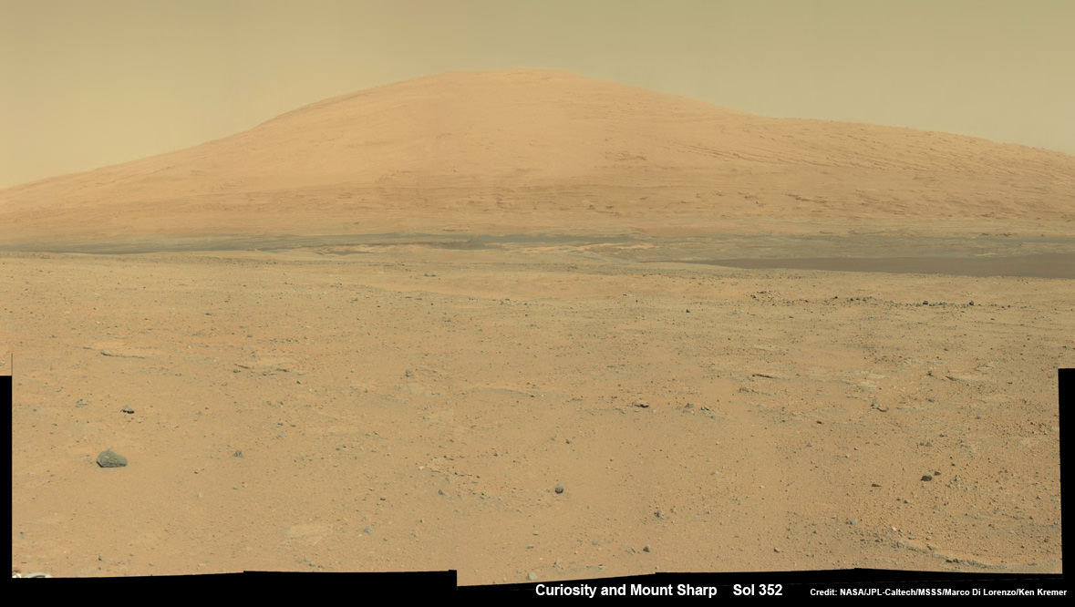
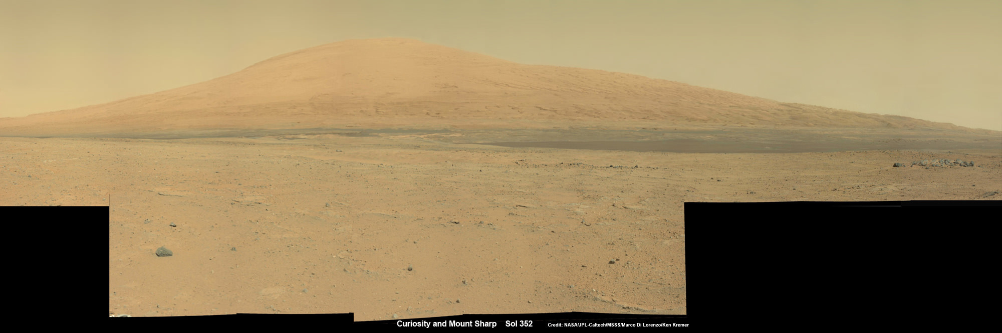
Curiosity Spies Mount Sharp - her primary destination. Curiosity will ascend mysterious Mount Sharp and investigate the sedimentary layers searching for clues to the history and habitability o the Red Planet of billions of years. This mosaic was assembled from Mastcam camera images taken on Sol 352 (Aug 2, 2013. Credit: NASA/JPL-Caltech/MSSS/ Marco Di Lorenzo/Ken Kremer
Curiosity Spies Mount Sharp – her primary destination. Curiosity will ascend mysterious Mount Sharp and investigate the sedimentary layers searching for clues to the history and habitability of the Red Planet over billions of years. But first she must safely trespass through the treacherous dark dunes fields. This mosaic was assembled from over 2 dozen Mastcam camera images taken on Sol 352 (Aug 2, 2013). Credit: NASA/JPL-Caltech/MSSS/ Marco Di Lorenzo/Ken Kremer
See the full mosaic below [/caption]
It’s never a dull moment for NASA’s Curiosity rover at T Plus 1 Year since touchdown on the Red Planet and T Minus 1 year to arriving at her primary target, the huge mountain overwhelming the center of the landing site inside Gale Crater.
Curiosity is literally and figuratively zooming in on stunningly beautiful and mysterious Mount Sharp (see our new mosaics above/below), her ultimate destination, while conducting ‘Science on the Go’ with her duo of chemistry labs – SAM and CheMin – and 8 other science instruments as she passes the 2 kilometer driving milestone today; Aug 20 !
“We are holding samples for drops to ChemMin and SAM when the science team is ready for it,” Jim Erickson, Curiosity Project Manager of NASA’s Jet Propulsion Laboratory (JPL), told Universe Today in an exclusive interview.
“Curiosity has landed in an ancient river or lake bed on Mars,” Jim Green, Director of NASA’s Planetary Science Division, told Universe Today.
So, those samples were altered by liquid Martian water – a prerequisite for life.
Curiosity Spies Mount Sharp – her primary destination. Curiosity will ascend mysterious Mount Sharp and investigate the sedimentary layers searching for clues to the history and habitability of the Red Planet over billions of years. But first she must safely trespass through the treacherous dark dunes fields. This mosaic was assembled from over 3 dozen Mastcam camera images taken on Sol 352 (Aug 2, 2013.
Credit: NASA/JPL-Caltech/MSSS/ Marco Di Lorenzo/Ken Kremer-kenkremer.com
In fact the car sized rover has saved samples from both the ‘John Klein’ and ‘Cumberland’ drill sites collected previously in the ‘Yellowknife Bay’ area for analysis by the miniaturized labs in the rovers belly -when the time is right.
“Curiosity has stored a Cumberland sample and still has a John Klein sample on board for future use,” Erickson explained.
And that time has now arrived!
“We have put a sample from the Cumberland drill hole into SAM for more isotopic measurements,” reported science team member John Bridges in a blog update on Sol 363, Aug. 14, 2013.
“The sample had been cached within the robotic arm’s turret.”
Curiosity is multitasking – conducting increasingly frequent traverses across the relatively smooth floor of Gale Crater while running research experiments for her science handlers back here on Earth.
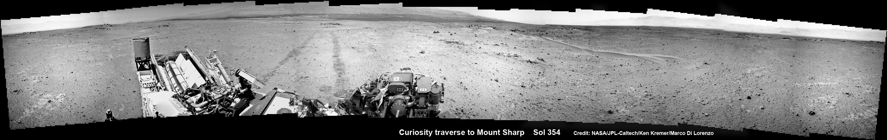
NASA’s Curiosity rover make tracks to Mount Sharp (at left) across the floor of Gale Crater. The rover paused to image the windblown ripple at right, below the hazy crater rim. The wheel tracks are about eight feet apart. This panoramic mosaic was assembled from a dozen navcam camera images taken on Sol 354 (Aug 4, 2013). Credit: NASA/JPL-Caltech/Ken Kremer/Marco Di Lorenzo
She’s captured stunning new views of Mount Sharp – rising 5 km (3 miles) high into the sky – and movies of Mars tiny pair of transiting moons while ingesting new portions of the drilled rock samples acquired earlier this year.
Here’s our video compilation of Phobos and Deimos transiting on Aug 1, 2013
Video caption: Transit of Phobos in front of Deimos, taken by MSL right MastCam imager on Sol 351 around 3:12 AM local time (Aug 1, 2013, 8:42 UTC); 16 original frames + 14 interpolated (5x speed-up). Credit: NASA/JPL-Caltech/MSSS/ Marco Di Lorenzo/Ken Kremer
The sample analysis is still in progress.
“The SAM data have not all been received yet,” wrote science team member Ken Herkenhoff in a blog update.
Earlier analysis of sample portions from both ‘John Klein’ and ‘Cumberland’ revealed that the Yellowknife Bay area on Mars possesses the key mineral ingredients proving that Red Planet was once habitable and could have sustained simple microbial life forms.
The scientists are seeking further evidence and have yet to detect organic molecules – which are the building blocks of life as we know it.
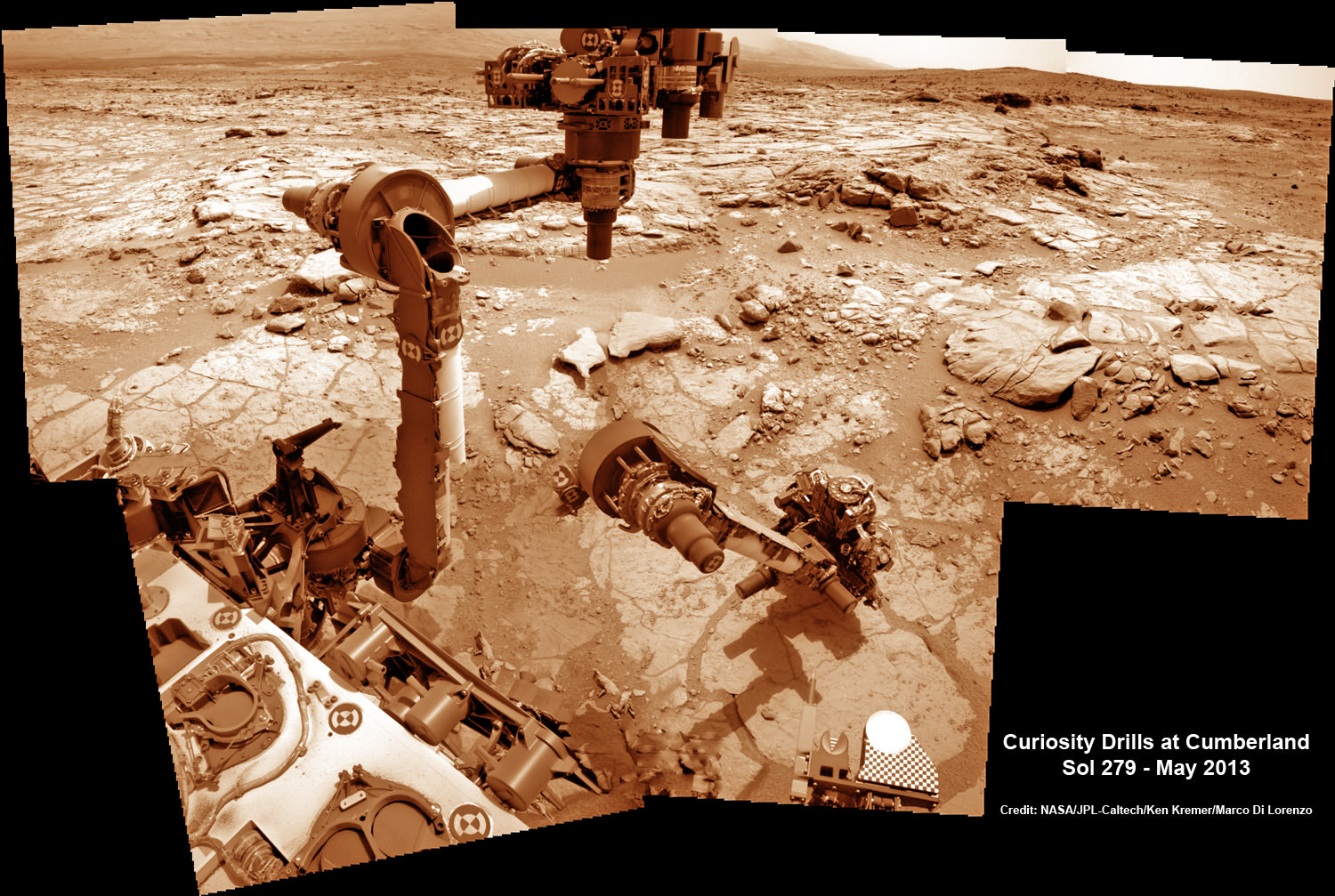
This time lapse mosaic shows Curiosity maneuvering her robotic arm to drill into her 2nd martian rock target named “Cumberland” to collect powdery Martian material on May 19, 2013 (Sol 279) for analysis by her onboard chemistry labs; SAM & Chemin- see 3 inlet ports lower left. The photomosaic was stitched from raw images captured by the navcam cameras on May 14 & May 19 (Sols 274 & 279). Credit: NASA/JPL-Caltech/Ken Kremer/Marco Di Lorenzo
Yellowknife Bay resembles a dried out river bed where liquid water once flowed eons ago when the Red Planet was far warmer and wetter than today.
As the 1 ton robot ascends Mount Sharp, she will examine sedimentary layers layed down on ancient Mars over hundreds of millions and perhaps billions of years of past history and habitability.
And just as the rover was celebrating 1 year on Mars on Aug 5/6, she found an intriguing sand dune on Sol 354. See our mosaic
“The rover paused to take images of its tracks after crossing a windblown ripple,” Herkenhoff reported.
As the six wheeled rover approaches Mount Sharp over the next year, she will eventually encounter increasing treacherous dunes that she must cross before beginning her mountain climbing foray.
As of today, Sol 369 (Aug. 20) Curiosity has broken through the 2 kilometer driving mark with a new 70 meter drive, snapped over 75,000 images and fired over 75,000 laser shots.
Mount Sharp is about 8 kilometers (5 miles) distant as the Martian crow flies.
How long will the journey to Mount Sharp require?
“Perhaps about a year,” Erickson told me. “We are trying to make that significantly faster by bringing autonav [autonomous navigation software] online.”
“That will help. But how much it helps really depends on the terrain.”
So far so good.
Meanwhile NASA’s next Mars orbiter called MAVEN (for Mars Atmosphere and Volatile Evolution), recently arrived at the Kennedy Space Center after a cross country flight.
Kennedy technicians are completing assembly and check out preparations for MAVEN’s blastoff to the Red Planet on Nov. 18 from Florida atop an Atlas V rocket similar to the one that launched Curiosity nearly 2 years ago.
And I’ll be at Kennedy to report up close on MAVEN’s launch.
Gather round the internets for another episode of the Weekly Space Hangout. Where our experienced team of journalists, astronomers and astronomer-journalists bring you up to speed on the big happenings in the universe of space and astronomy.
Our team this week:
Reporters: Casey Dreier, David Dickinson, Amy Shira Teitel, Sondy Springmann, Nicole Gugliuci
We record the Weekly Space Hangout every Friday at Noon Pacific, 3 pm Eastern. Join us live here on Universe Today, over on our YouTube account, or on Google+. Or you can watch the archive after the fact.
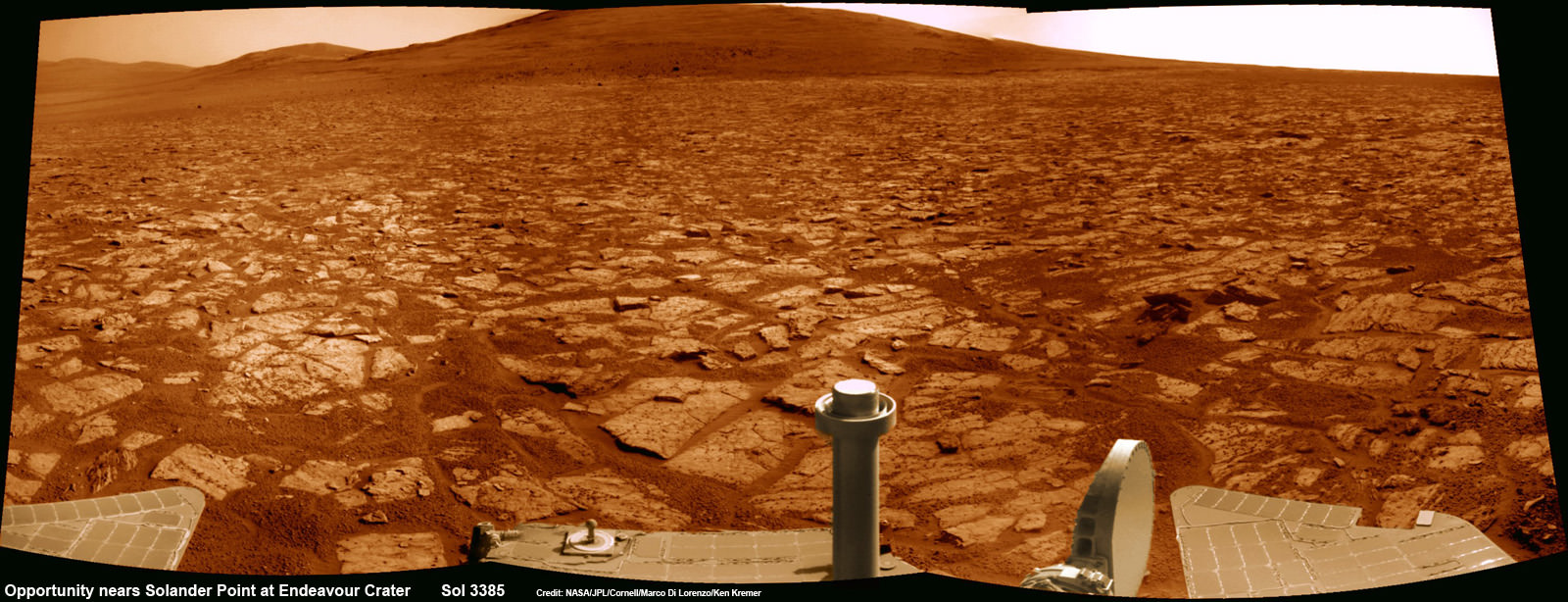
Opportunity rover’s 1st mountain climbing goal is dead ahead in this up close view of Solander Point along the eroded rim of Endeavour Crater. Opportunity will soon ascend the mountain in search of minerals signatures indicative of a past Martian habitable environment. This navcam panoramic mosaic was assembled from raw images taken on Sol 3385 (Aug 2, 2013). Credit: NASA/JPL/Cornell/Marco Di Lorenzo/Ken Kremer (kenkremer.com)
Opportunity rover’s 1st mountain climbing goal is dead ahead in this up close view of Solander Point at Endeavour Crater. Opportunity will ascend the mountain looking for clues indicative of a Martian habitable environment. This navcam panoramic mosaic was assembled from raw images taken on Sol 3385 (Aug 2, 2013).
Credit: NASA/JPL/Cornell/Marco Di Lorenzo/Ken Kremer (kenkremer.com)[/caption]
NASA’s most powerful Mars orbiter has been given the green light today (Aug. 5) to capture new high resolution spectral scans that are absolutely crucial for directing the long lived Opportunity rover’s hunt for signatures of habitability atop the intriguing mountain she will soon ascend.
In a plan only recently approved by NASA, engineers are aiming the CRISM mineral mapping spectrometer aboard the Mars Reconnaissance Orbiter (MRO) circling overhead to collect high resolution survey scans of Solander Point – Opportunity’s 1st mountain climbing goal along the rim of huge Endeavour Crater.
“New CRISM observations centered over Solander Point will be acquired on Aug. 5, 2013,” Ray Arvidson told Universe Today exclusively. Arvidson is the mission’s deputy principal scientific investigator from Washington University in St. Louis, Mo.
NASA’s decade old rover Opportunity is about to make ‘landfall’ at the base of Solander Point, the Martian mountain she will scale in search of the chemical ingredients that could sustain Martian microbes.
So the new spectral data can’t come back to Earth soon enough.
Currently, the science team lacks the same quality of high resolution CRISM data from Solander Point that they had at a prior stop at Cape York. And that data was crucial because it allowed the rover to be precisely targeted – and thereby discover a habitable zone, Arvidson told me.
“CRISM collected lots of overlapping measurements at Cape York to sharpen the image resolution to 5 meters per pixel to find the phyllosilicate smectite [clay minerals] signatures at Matejivic Hill on Cape York.”
“We don’t have that at Solander Point. We only have 18 meters per pixel data. And at that resolution you can’t tell if the phyllosilicate smectite [clay minerals] outcrops are present.”
Today’s new survey from Mars orbit will vastly improve the spectral resolution – from 18 meters per pixel down to 5 meters per pixel.
“5 meter per pixel CRISM resolution is expected in the along-track direction over Solander Point by commanding the gimbaled optical system to oversample that much,” Arvidson explained.
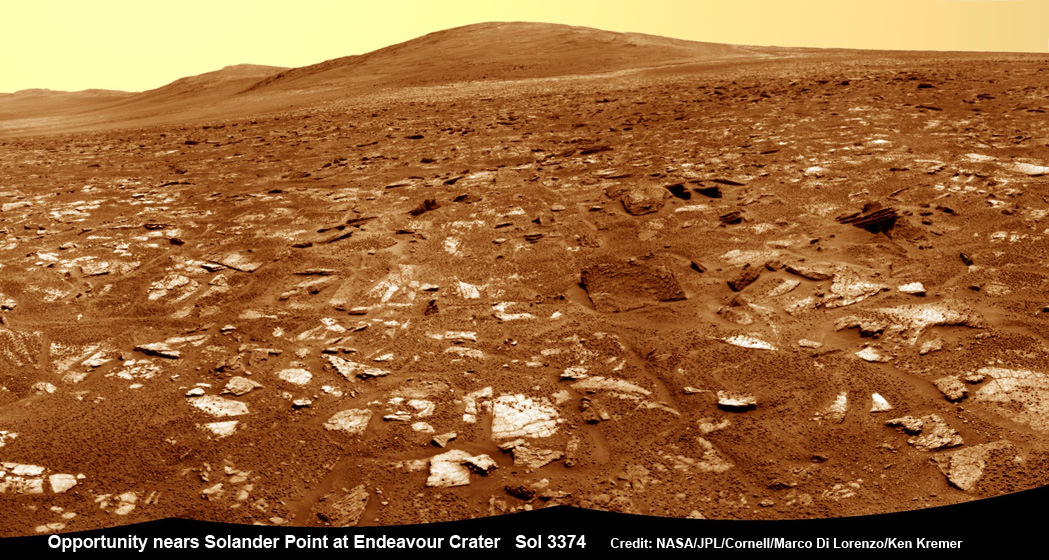
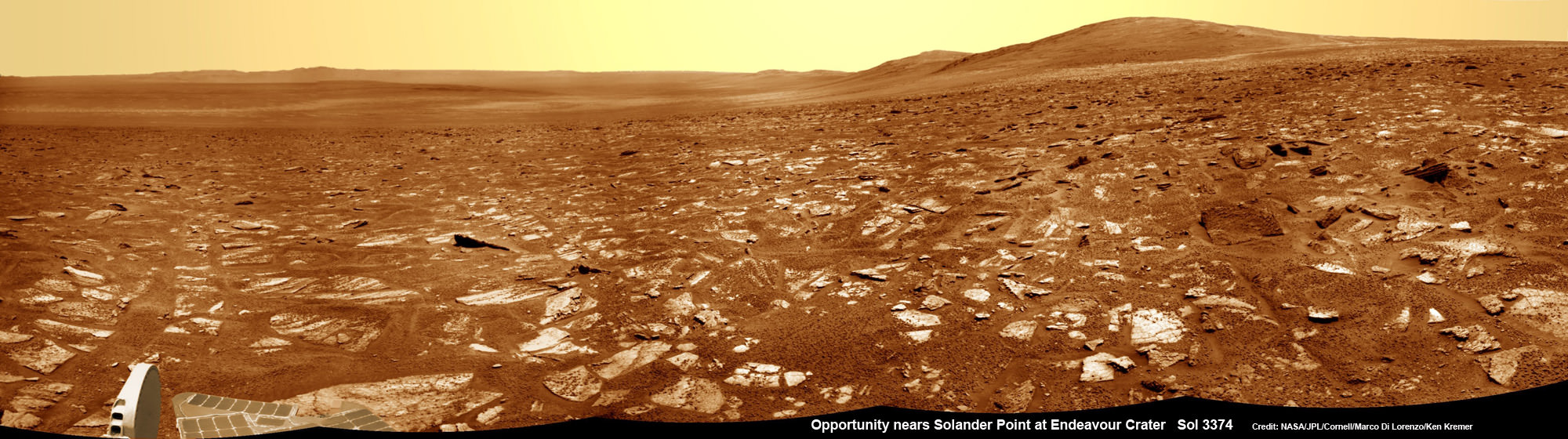
Opportunity rover’s view from very near the foothills of Solander Point looking along the rim and vast expanse of Endeavour Crater. Solander Point is the 1st Martian Mountain NASA’s Opportunity will climb and the rovers next destination. Solander Point may harbor clay minerals indicative of a past Martian habitable environment. This navcam mosaic was assembled from raw images taken on Sol 3374 (July 21, 2013). Credit: NASA/JPL/Cornell/Marco Di Lorenzo/Ken Kremer (kenkremer.com)
The new CRISM spectral survey from Mars is essential to enable the science team to carefully study the alien, unexplored terrain in detail and locate the clay minerals and other water bearing minerals, even before the rover arrives.
Clay minerals form in neutral pH water conducive to life.
Opportunity would then be commanded to drive to preselected sites to conduct “ground truth” forays at Solander.
That’s just like was done at Cape York and the “Esperance” rock loaded with clay minerals that turned into one of the “Top 5 discoveries of the mission” according to Arvidson and Steve Squyres, Opportunity’s Science Principal Investigator of Cornell.
But it took some cajoling and inter team negotiations to convince everyone to move forward with the special but crucial CRISM imaging plan.
Since MRO is getting on in age – it launched in 2005 – NASA and the spacecraft managers have to carefully consider special requests such as this one which involves slewing the MRO spacecraft instruments and therefore entails some health risks to the vehicle.
“CRISM has been operating at Mars since 2006 and sometimes the optics on a gimble have actuators that get stuck a little bit and don’t sweep as fully as planned.”
Nevertheless, Arvidson told me a few weeks ago he was hopeful to get approval.
“I suspect I can talk the team into it.”
And eventually he did! And informed me for the readers of Universe Today.
The fact that the Opportunity scientists already scored a ‘Science Home Run’ with their prior CRISM targeting request at Cape York certainly aided their cause immensely.
The new approved CRISM measurements due to be captured today will give Opportunity the best chance to be targeted to the most promising mineral outcrops, and as quickly as possible.
“With the coordinated observations from CRISM and Opportunity we will go into Solander Point a lot smarter!”
“And we’ll have a pretty good idea of what to look for and where,” Arvidson told me.
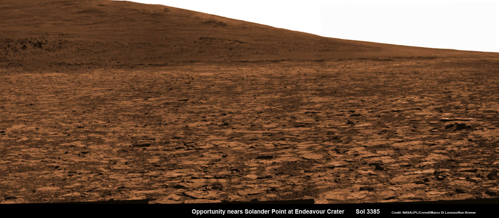
Opportunity snap up close view of the base of Solander Point and mountain slopes she will ascend soon. This hi res pancam camera mosaic was assembled from raw images taken on Sol 3385 (Aug 2, 2013). Credit: NASA/JPL/Cornell/ASU/Marco Di Lorenzo/Ken Kremer (kenkremer.com)
Today marks Opportunity’s 3389th Sol or Martian day roving Mars. Merely 90 days were expected!
Having completed her investigation of the rocky crater plains, the rover continues to drive south.
Any day now Opportunity will drive onto the Bench surrounding Solander and start a new phase of the mission.
Since she basically arrived at Solander with plenty of power and ahead of schedule prior to the onset of the 6th Martian winter, the robot has some spare time to investigate the foothills before ascending the north facing slopes.
“We will be examining the bench and then working our way counterclockwise to reach the steep slopes associated with the Noachian outcrops that are part of the Endeavour rim,” Arvidson said.
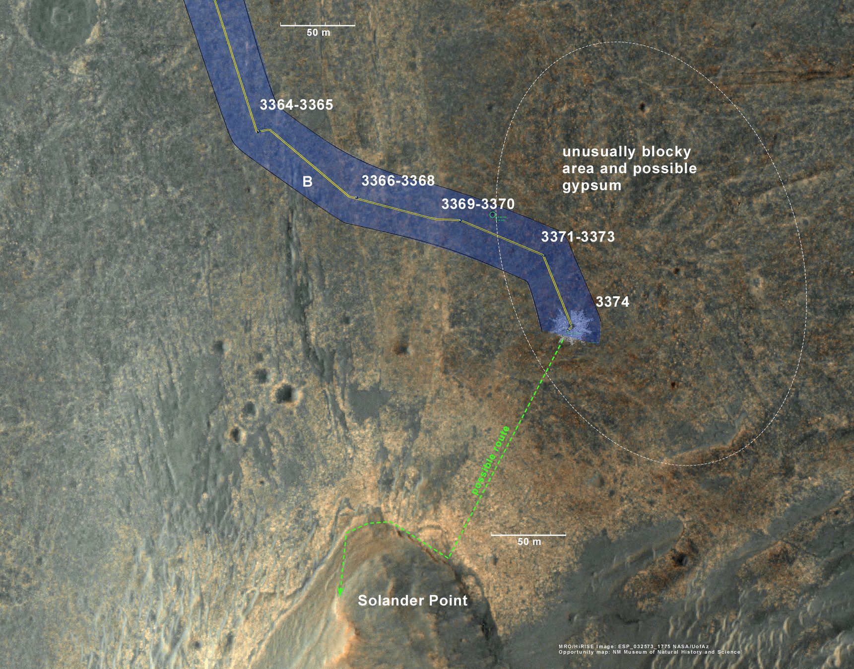
Ken Kremer Opportunity rover location in the latest MRO/HiRISE color image. The green line shows more or less the route we hope to take to the base of Solander point. Since it is only a couple of hundred meters away, we could be there is a couple of drives. Maybe by the end of next week. The label say “3374” but this is also roughly the location through 3379. Credit: NASA/JPL/Larry Crumpler
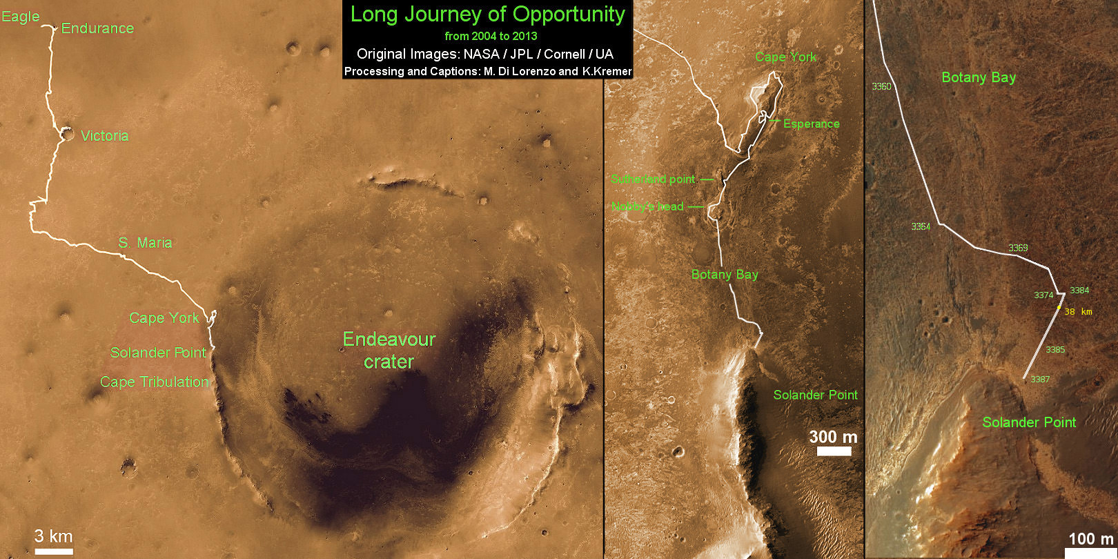
Traverse Map for NASA’s Opportunity rover from 2004 to 2013
This map shows the entire path the rover has driven during more than 9 years and over 3387 Sols, or Martian days, since landing inside Eagle Crater on Jan 24, 2004 to current location near foothills of Solander Point at the western rim of Endeavour Crater. Opportunity discovered clay minerals at Esperance – indicative of a habitable zone. Credit: NASA/JPL/Cornell/ASU/Marco Di Lorenzo/Ken Kremer
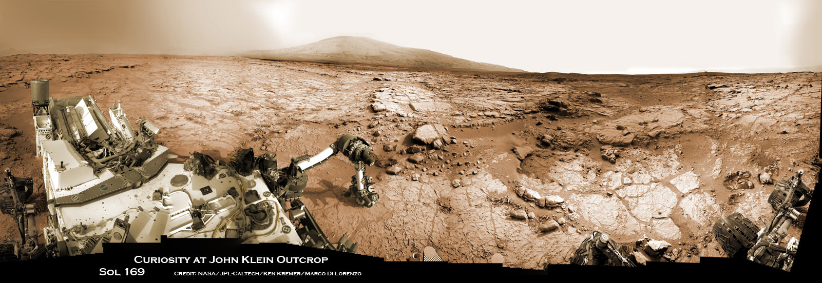
Curiosity accomplished Historic 1st drilling into Martian rock at John Klein outcrop on Feb 8, 2013 (Sol 182), shown in this context mosaic view of the Yellowknife Bay basin taken on Jan. 26 (Sol 169). The robotic arm is pressing down on the surface at John Klein outcrop of veined hydrated minerals – dramatically back dropped with her ultimate destination; Mount Sharp. Credit: NASA/JPL-Caltech/Ken Kremer/Marco Di Lorenzo
Curiosity accomplished Historic 1st drilling into Martian rock at John Klein outcrop on Feb 8, 2013 (Sol 182), shown in this context mosaic view of the Yellowknife Bay basin taken on Jan. 26 (Sol 169). The robotic arm is pressing down on the surface at John Klein outcrop of veined hydrated minerals – dramatically back dropped with her ultimate destination; Mount Sharp.
Credit: NASA/JPL-Caltech/Ken Kremer/Marco Di Lorenzo Story updated with further details[/caption]
NASA’s mega Mars rover Curiosity is celebrating 1 Year on the Red Planet since the dramatic landing on Aug. 6, 2012 by reveling in a string of groundbreaking science discoveries demonstrating that Mars could once have supported past life – thereby accomplishing her primary science goal – and with a promise that the best is yet to come!
“We now know Mars offered favorable conditions for microbial life billions of years ago,” said the mission’s project scientist, John Grotzinger of the California Institute of Technology in Pasadena.
“Curiosity has landed in an ancient river or lake bed on Mars,” Jim Green, Director of NASA’s Planetary Science Division, told Universe Today.
Curiosity is now speeding onwards towards Mount Sharp, the huge 3.4 mile (5. 5 km) mountain dominating the center of her Gale Crater landing site – and which is the primary destination of the mission.
During Year 1, Curiosity has transmitted over 190 gigabits of data, captured more than 71,000 images, fired over 75,000 laser shots to investigate the composition of rocks and soil and drilled into two rocks for sample analysis by the pair of state-of-the-art miniaturized chemistry labs housed in her belly – SAM & CheMin.
“From the sophisticated instruments on Curiosity the data tells us that this region could have been habitable in Mars’ distant past,” Green told me.
“This is a major step forward in understanding the history and evolution of Mars.”
And just in the nick of time for her 1 year anniversary, the car sized robot just passed the 1 mile (1.6 kilometer) driving mark on Aug. 1, or Sol 351.
Mount Sharp still lies roughly 5 miles (8 kilometers) distant – as the Martian crow flies.
“We will be on a general heading of southwest to Mount Sharp,” Jim Erickson, Curiosity Project Manager of NASA’s Jet Propulsion Laboratory (JPL), told Universe Today in an exclusive interview. See the NASA JPL route maps below.
“We have been going through various options of different planned routes.”
How long will the journey to Mount Sharp take?
“Perhaps about a year,” Erickson told me.
“We have put some new software – called autonav, or autonomous navigation – on the vehicle right after the conjunction period back in March 2013. This will increase our ability to drive.”
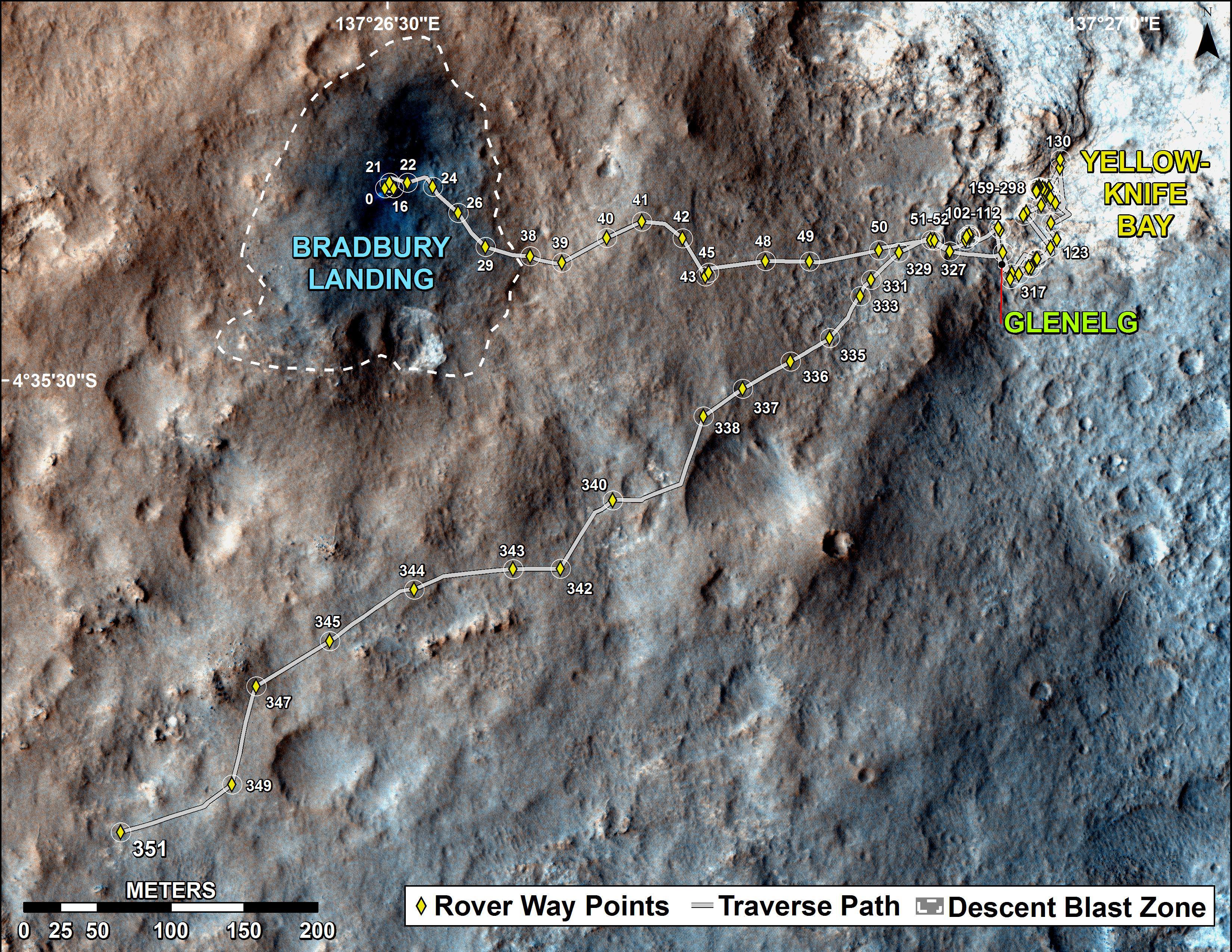
The total distance driven by NASA’s Mars rover Curiosity passed the one-mile mark a few days before the first anniversary of the rover’s landing on Mars. This map traces where Curiosity drove between landing at “Bradbury Landing” on Aug. 5, 2012, PDT, (Aug. 6, 2012 (Universal Time and EDT) and the position reached during the mission’s 351st Martian day, or sol, (Aug. 1, 2013). The Sol 351 leg added 279 feet (85.1 meters) and brought the odometry since landing to about 1.05 miles (1,686 meters). Credit: NASA/JPL-Caltech/Univ. of Arizona
“We are trying to make that significantly faster by bringing the new autonav online. That will help. But how much it helps really depends on the terrain.”
So far the terrain has not been problematical.
“Things are going very well and we have a couple of drives under our belt,” said Erickson, since starting the long trek to Mount Sharp about a month ago.
The lower reaches of Mount Sharp are comprised of exposed geological layers of sedimentary materials that formed eons ago when Mars was warmer and wetter, and much more hospitable to microscopic life.
“It has been gratifying to succeed, but that has also whetted our appetites to learn more,” says Grotzinger. “We hope those enticing layers at Mount Sharp will preserve a broad diversity of other environmental conditions that could have affected habitability.”
Indeed, Curiosity’s breakthrough discovery that the surface of Mars possesses the key chemical ingredients required to sustain microbial life in a habitable zone, has emboldened NASA to start mapping out the future of Mars exploration.
“NASA’s Mars program is back on track with the 2016 InSight lander and the 2020 rover,” Jim Green, Director of NASA’s Planetary Science Division, told Universe Today in an interview.
“Successes of our Curiosity — that dramatic touchdown a year ago and the science findings since then — advance us toward further exploration, including sending humans to an asteroid and Mars,” said NASA Administrator Charles Bolden in a statement.
“Wheel tracks now, will lead to boot prints later.”
Following the hair-raising touchdown using with the never before used sky-crane descent thrusters, the science team directed the 1 ton robot to drive to a nearby area of interesting outcrops on the Gale crater floor – at a place called Glenelg and Yellowknife Bay.
Along the way, barely 5 weeks after landing, Curiosity found a spot laden with rounded pebbles at the Hottah outcrop of concretions that formed in an ancient stream bed where hip deep liquid water once flowed rather vigorously.
In February 2013, Curiosity conducted the historic first ever interplanetary drilling into Red Planet rocks at the ‘John Klein’ outcrop inside Yellowknife Bay that was shot through with hydrated mineral veins of gypsum.
The Yellowknife Bay basin looks like a dried up river bed.
This scene combines seven images from the telephoto-lens camera on the right side of the Mast Camera (Mastcam) instrument on NASA’s Mars rover Curiosity on Sol 343 of the rover’s work on Mars (July 24, 2013). The center of the scene is toward the southwest. Credit: NASA/JPL-Caltech/Malin Space Science Systems
Analysis of pulverized portions of the gray colored rocky powder cored from the interior of ‘John Klein’ revealed evidence for phyllosilicates clay minerals that typically form in pH neutral water. These starting findings on the crater floor were unexpected and revealed habitable environmental conditions on Mars – thus fulfilling the primary science goal of the mission.
See herein our context panoramic mosaic from Sol 169 showing the robotic arm touching and investigating the Martian soil and rocks at ‘John Klein’.
And if you take a visit to Washington, DC, you can see our panorama (assembled by Ken Kremer and Marco Di Lorenzo) on permanent display at a newly installed Solar System exhibit at the US National Mall in front of the Smithsonian National Air & Space Museum- details here.
A mosaic by the Mars Science Laboratory Curiosity rover, assembled by Ken Kremer and Marco Di Lorenzo is now part of the permanent Solar System Exhibit outside the National Air and Space Museum on the US National Mall in Washington, D.C. Image courtesy NCESSE.
“We have found a habitable environment [at John Klein] which is so benign and supportive of life that probably if this water was around, and you had been on the planet, you would have been able to drink it,” says Grotzinger, summing up the mission.
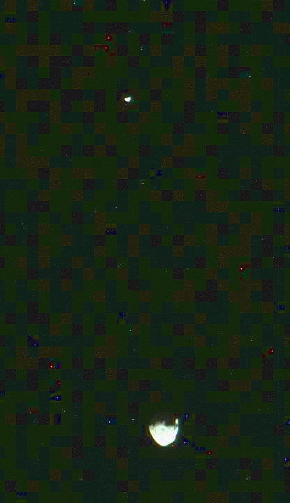
Curiosity captured unique and rare view of tiny Martian moons Phobos & Deimos together on Sol 351 (Aug 1, 2013). Look close and see craters on pockmarked Phobos. Credit: NASA/JPL/MSSS, contrast enhanced by Marco Di Lorenzo and Ken KremerOn the long road to Mount Sharp, Curiosity will make occasional stops for science.
This past week she captured rare sky watching images of the diminutive Martian moons – Phobos and Deimos – together!
Meanwhile, Curiosity’s 10 year old sister rover Opportunity Is trundling merrily along and will arrive shortly at her own mountain climbing goal on the opposite of Mars.
And NASA’s next Mars orbiter called MAVEN (for Mars Atmosphere and Volatile Evolution), has just arrived intact at the Kennedy Space Center after a cross country trip aboard a USAF C-17.
Technicians at Kennedy will complete final preparations for MAVEN’s blastoff to the Red Planet on Nov. 18 from the Florida Space Coast atop an Atlas V rocket.
On Tuesday, Aug 6, NASA will broadcast a half day of new programming on NASA TV commemorating the landing and discussing the science accomplished so far and what’s coming next.
And stay tuned for more astonishing discoveries during ‘Year 2’ on the Red Planet from our intrepid rover Curiosity – Starting Right Now !
Curiosity Route Map From ‘Glenelg’ to Mount Sharp
This map shows where NASA’s Mars rover Curiosity landed in August 2012 at “Bradbury Landing”; the area where the rover worked from November 2012 through May 2013 at and near the “John Klein” target rock in the “Glenelg” area; and the mission’s next major destination, the entry point to the base of Mount Sharp. Credit: NASA/JPL-Caltech/Univ. of Arizona
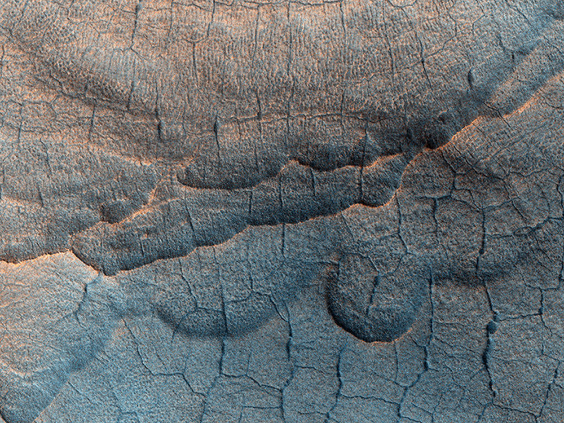
The surface of Utopia Planitia on Mars. Credit: NASA/JPL/University of Arizona.
The name of this large impact basin on Mars, Utopia Planitia, sounds idyllic. But it also strikes a warm place in the heart of any Trekkie, as in the future (at least in the Star Trek Universe) it will be the location of the facility where the original Starship Enterprise and its many incarnations will be built. While the majority of the Utopia Planitia Shipyards are in geosynchronous orbit of Mars, there are also facilities on the planet as well, according to the Utopia Planitia Yards Starship Guide website. Uptopia Planitia was “found to be the ideal location [for the Shipyard], and a number of planetary sites are developed along with an expansive orbital facility located in geosynchronous orbit directly above,” explains the site.
But back to the present and this beautiful image from the HiRISE camera on board the Mars Reconnaissance Orbiter.
What is striking about the image are the polygon-shaped patterns of troughs and large scallop-shaped depressions. Mike Mellon, writing on the HiRISE website explains that collectively, such landforms are referred to as “thermokarst,” which both point to a slightly warmer and wetter Mars in the past.
Writes Mellon:
Under the proper climate conditions ice may form and seasonally accumulate in a honeycomb network of vertical fractures that appear when ice-rich soil contracts each winter. On Earth this form of subsurface ice is called an “ice wedge.” Special conditions are needed for this ice to accumulate and develop into a large wedge, namely warm temperature and abundant surface water. A thick layer of thawed wet soil forms allowing water to percolate into the open contraction cracks within the permafrost beneath. Later, loss of this wedge ice, by for example sublimation, results in deep depressions marking the honeycomb network.
Likewise, the larger scallop depressions might point to a past climate of frozen ponds or local patches of windblown snow collected in hollows. These surface ice deposits could later be covered by the ever-shifting soils and dust. In either case, the currently bitter cold and dry climate of Mars is not conducive to forming either of these buried-ice forms. Therefore, these landforms point to a warmer, but still cold, climate in the geologic past.
This image just highlights why I’m such a big fan of the HiRISE camera: a gorgeous image of our neighboring planet that was taken just last month from a spaceship orbiting Mars RIGHT NOW that tells us more about the past, while giving hope for our potentially space-faring future.
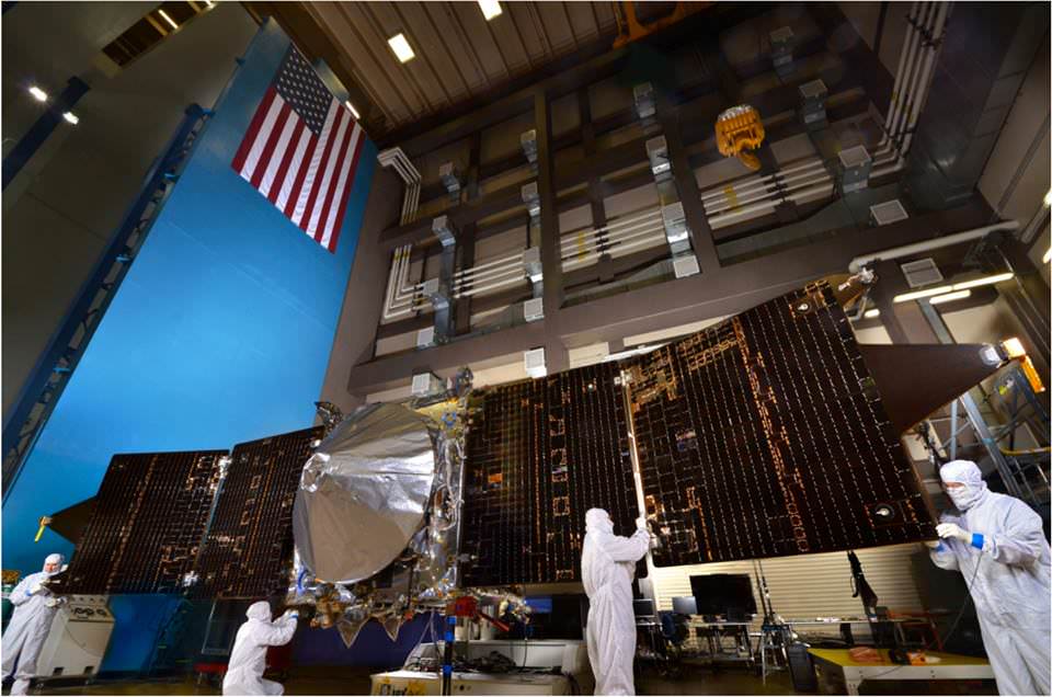
The solar panels on the MAVEN spacecraft are deployed as part of environmental testing procedures at Lockheed Martin Space Systems in Littleton, Colorado, before shipment to Florida 0on Aug. 2 and blastoff for Mars on Nov. 18, 213. Credit: Lockheed Martin
The solar panels on NASA’s MAVEN Mars orbiter are deployed as part of environmental testing procedures at Lockheed Martin Space Systems in Littleton, Colorado, before shipment to Florida on Aug. 2 and blastoff for Mars on Nov. 18, 2013. Credit: Lockheed Martin Watch cool testing videos below![/caption]
MAVEN is NASA’s next mission to Mars and in less than three days time the spacecraft ships out on a cross country trek for the first step on the long sojourn to the Red Planet.
But before all that, technicians took MAVEN for a final spin test, flexed her solar arrays and bombarded her with sound and a whole lot more.
On Aug. 2, MAVEN (Mars Atmosphere and Volatile EvolutioN Mission) journeys half a continent from its assembly facility at Lockheed Martin in Littleton, Colorado to the Kennedy Space Center and the Florida Space Coast aboard a USAF C-17.
Unlike Curiosity, which is roving across a crater floor on the Red Planet at this very moment, MAVEN is an orbiter with a first of its kind mission.
MAVEN is the first spacecraft from Earth devoted to investigating and understanding the upper atmosphere of Mars.
The goal is determining how and why Mars lost virtually all of its atmosphere billions of years ago, what effect that had on the climate and where did the atmosphere and water go?
To ensure that MAVEN is ready for launch, technicians have been busy this year with final tests of the integrated spacecraft.
Check out this video of MAVEN’s Dry Spin Balance Test
The spin balance test was conducted on the unfueled spacecraft on July 9, 2013 at Lockheed Martin Space Systems in Littleton, Colorado.
NASA says the purpose of the test “is to ensure that the fully integrated spacecraft is correctly balanced and to determine the current center of gravity. It allows the engineering team to fine-tune any necessary weight adjustments to precisely fix the center of gravity where they want it, so that it will perform as expected during the cruise to Mars.”
It was the last test to be completed on the integrated spacecraft before its shipment to Florida later this week.
This next video shows deployment tests of the two “gull-wing” solar panels at Lockheed Martin Space Systems.
Wingtip to wingtip, MAVEN measures 11.43 m (37.5 feet) in length.
In mid May, MAVEN was moved into a Thermal Vacuum Chamber at Lockheed Martin for 19 days of testing.
The TVAC test exposed MAVEN to the utterly harsh temperatures and rigors of space similar to those it will experience during its launch, cruise, and mission at Mars.
MAVEN is slated to blast off atop an Atlas V-401 rocket from Cape Canaveral Air Force Station, Florida on Nov. 18, 2013. The 2000 pound (900 kg) spacecraft will be housed inside a 4 meter payload fairing.
After a 10 month interplanetary voyage it will join NASA’s armada of four robotic spacecraft when it arrives in Mars orbit in September 2014.
Scientists hope that measurements from MAVEN will help answer critical questions like whether, when and how long the Martian atmosphere was once substantial enough to sustain liquid water on its surface and support life.
“What we’re doing is measuring the composition of the atmosphere as a measure of latitude, longitude, time of day and solar activities,” said Paul Mahaffy, of NASA’s Goddard Space Flight Center in Greenbelt, Md, and the principal investigator for MAVEN’s mass spectrometer instrument.
“We’re trying to understand over billions of years how the atmosphere has been lost.”
…………….
Learn more about MAVEN, Cygnus, Antares, LADEE, Mars rovers and more at Ken’s upcoming lecture presentations
Aug 12: “RockSat-X Suborbital Launch, LADEE Lunar & Antares Rocket Launches from Virginia”; Rodeway Inn, Chincoteague, VA, 8 PM
Oct 3: “Curiosity and the Search for Life on Mars – (3-D)”, STAR Astronomy Club, Brookdale Community College & Monmouth Museum, Lincroft, NJ, 8 PM
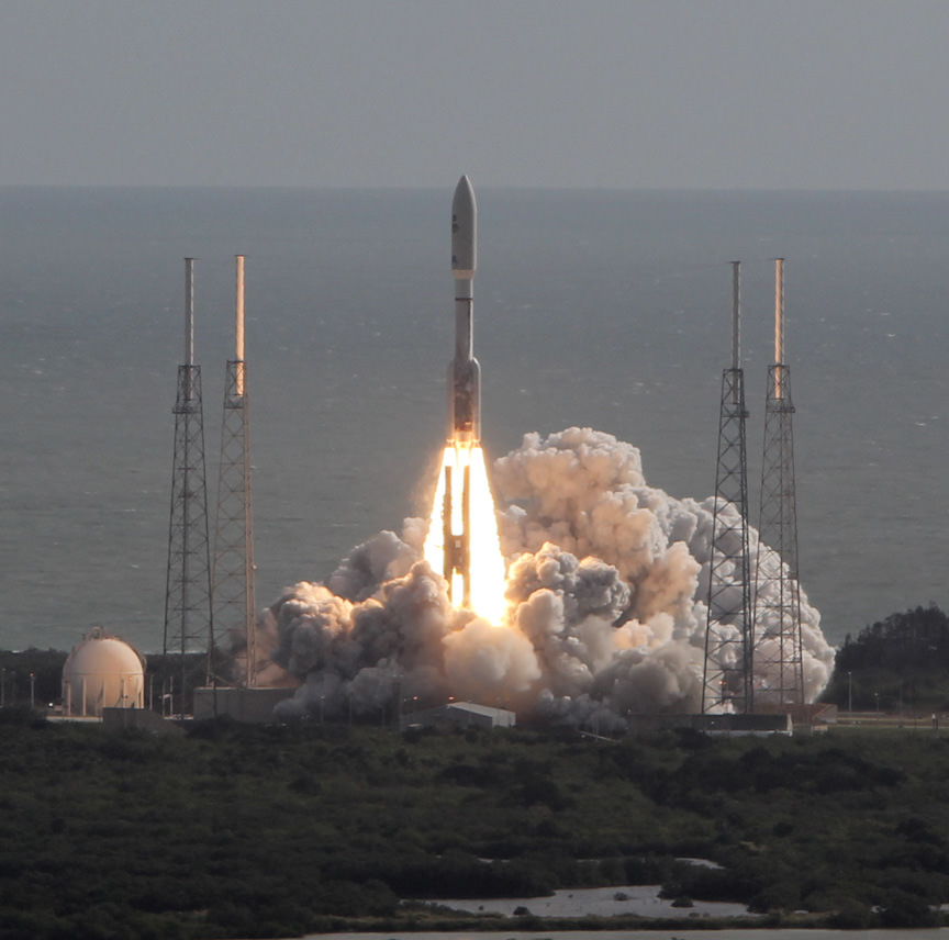
NASA’s MAVEN orbiter is due to blast off for Mars on Nov. 18, 2013 atop an Atlas V rocket similar to this which launched Curiosity from Cape Canaveral on Nov. 26, 2011. Credit: Ken Kremer/kenkremer.com
Opportunity rover’s view from very near the foothills of Solander Point looking along the rim and vast expanse of Endeavour Crater. Solander Point is the 1st Martian Mountain NASA’s Opportunity will climb and the rovers next destination. Solander Point may harbor clay minerals indicative of a past Martian habitable environment. This navcam mosaic was assembled from raw images taken on Sol 3374 (July 21, 2013). Credit: NASA/JPL/Cornell/Marco Di Lorenzo/Ken Kremer (kenkremer.com) See complete panoramic mosaic below
Opportunity rover’s view from very near the foothills of Solander Point looking along the rim and vast expanse of Endeavour Crater. This area exhibits gypsum signatures and numerous blocks of intriguing rock. Solander Point is the 1st Martian Mountain NASA’s Opportunity will climb and the rovers next destination. Solander Point may harbor clay minerals indicative of a past Martian habitable environment. This navcam mosaic was assembled from raw images taken on Sol 3374 (July 21, 2013). Credit: NASA/JPL/Cornell/Marco Di Lorenzo/Ken Kremer (kenkremer.com).
See complete panoramic mosaic below. Story updated with further details[/caption]
Exactly a decade after blasting off for the Red Planet and discovering a wide swath of water altered rocks and minerals in the ensuing years by exploring countless craters large and small, NASA’s intrepid Opportunity rover is just days away from arriving at her next big quest – a Martian mountain named Solander Point that may possess the key chemical ingredients necessary to sustain Martian life forms.
“We are parked 200 meters away from the bench at Solander Point,” Ray Arvidson told Universe Today exclusively. Arvidson is the mission’s deputy principal scientific investigator from Washington University in St. Louis, Mo. Furthermore, this area exhibits signatures related to water flow.
Solander Point also represents ‘something completely different’ – the first mountain the intrepid robot will ever climb.
“This will be Opportunity’s first mountain and the view from the ridge crest should be spectacular,” wrote Larry Crumpler, a science team member from the New Mexico Museum of Natural History & Science, in his latest field report about the 10 years ongoing Mars Exploration Rover (MER) mission.
Indeed the rover is now just a few short drives southward from making landfall on the northern tip of the point in her current trek across the relatively flat plains around the rim of Endeavour crater.
“We are now only about 180 meters from the new mountain, Solander Point.”
Opportunity rover location in the latest MRO/HiRISE color image. The green line shows more or less the route we hope to take to the base of Solander point. Since it is only a couple of hundred meters away, the rover could be there is a couple of drives. Maybe by the end of next week. The label say “3374” but this is also roughly the location through 3379. NASA/JPL/Larry Crumpler
But before moving onward, Arvidson explained that the rover will briefly pause here “at dark terrain” for some exciting science due to water related spectral observations from the CRISM instrument captured by NASA’s Mars Reconnaissance Orbiter (MRO) circling overhead.
“CRISM data [from Mars orbit] shows a relatively deep 1.9 micrometer absorption feature due to H2O-bearing minerals,” said Arvidson.
This past spring, Opportunity made the historic discovery of clay minerals and a habitable environment on a low hill called Cape York at the rover’s prior stop along the rim of Endeavour crater.
Solander was selected as the robot’s next destination because it simultaneously offers a goldmine of science as well as north facing slopes – where Opportunity’s solar wings can more effectively soak up the sun’s rays to generate life giving electrical power during the next Martian winter.
But since Opportunity is currently generating plenty of power from her solar arrays and arriving with a bonus cushion of time before the looming onset of her 6th Martian winter, the team decided to take a small detour to the southeast and spend several sols (or Martian days) exploring an area of intriguing geology of outcrops, gypsum signatures and more on the bench surrounding the base of the mountain.
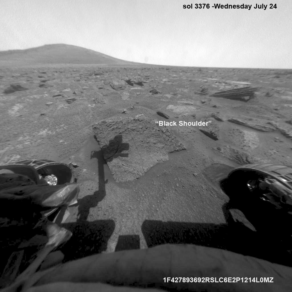
“We slowed down this week so that we could check out the rocks here where there is a strange hydration signature from orbital remote sensing,” says Crumpler.
“This is also an area that appears to have more large blocks in the HiRISE images [from Mars orbit], so we are checking out one of the blocks, “Black Shoulder”.
“We are hoping that the rocks on the ridge crest will be spectacular too,” notes Crumpler.
Opportunity rover’s view very near the foothills of Solander Point along the rim and vast expanse of Endeavour Crater. This area exhibits gypsum signatures and numerous blocks of intriguing rock. Solander Point is the 1st Martian Mountain NASA’s Opportunity will climb and the rovers next destination. Solander Point may harbor clay minerals indicative of a past Martian habitable environment. This navcam panoramic mosaic was assembled from raw images taken on Sol 3374 (July 21, 2013). Credit: NASA/JPL/Cornell/Marco Di Lorenzo/Ken Kremer (kenkremer.com)
Opportunity is using the science instruments on her 3 foot ( 1 meter) long robotic arm to conduct brief in-situ investigations of “Black Shoulder” with the Microscopic Imager (MI) and the Alpha Particle X-ray Spectrometer (APXS).
And …. it’s ‘Mountains Galore’ from here on out for the remainder of Opportunity’s Magnificent Mission to Mars.
Why? Because Opportunity is nearing the foothills of a long chain of eroded segments of the crater wall of Endeavour crater which spans a humongous 14 miles (22 kilometers) wide.
Solander Point may harbor deposits of phyllosilicate clay minerals – which form in neutral pH water – in a thick layer of rock stacks indicative of a past Martian habitable zone.
The rover team is discussing the best way to approach and drive up Solander.
“One idea is to drive part way up Solander from the west side of the rim, turn left and then drive down the steeper north facing slopes with the stratographic sections,” Ray Arvidson explained to Universe Today.
“That way we don’t have to drive up the relatively steeper slopes.”
“The rover can drive up rocky surfaces inclined about 12 to 15 degrees.”
“We want to go through the stratographic sections on the north facing sections,” Arvidson told me.
Opportunity rover moves closer to the foothills of Solander Point along the rim and vast expanse of Endeavour Crater. The rover investigated one of the large rocks near here with her microscopic imager and X-Ray spectrometer. Soon she will start climbing up Solander – her 1st Martian Mountain ascent. This navcam panoramic mosaic was assembled from raw images taken on Sol 3376 (July 23, 2013).
Credit: NASA/JPL/Cornell/Marco Di Lorenzo/Ken Kremer (kenkremer.com)
Today (July 28) is Sol 3380 for a mission that was only warrantied to last 90 Sols!
Opportunity’s total driving distance exceeds 23.6 miles (37.9 kilometers). She has snapped over 182,000 images.
The “work volume”. This view from the front hazcams shows the rock target that is being checked out before the final slog to the south. With luck, by the end of next week we will be plinking around the base of yonder mountain. “Plinking” is a geological term for wandering around with your hammer trying to get a handle on the local outcrops before plunging ahead with mapping and asking the rocks serious questions. Credit: NASA/JPL/Larry Crumpler
Meanwhile on the opposite side of Mars at Gale Crater, Opportunity’s younger sister rover Curiosity also discovered a habitable environment originating from a time when the Red Planet was far warmer and wetter billions of years ago.
And like Opportunity, Curiosity is also trekking towards a mountain rich in sedimentary layers hoping to unveil the mysteries of Mars past. But Curiosity likely won’t arrive at 3.4 mile (5.5 km) high Mount Sharp for another year.
Traverse Map for NASA’s Opportunity rover from 2004 to 2013
This map shows the entire path the rover has driven during more than 9 years and over 3374 Sols, or Martian days, since landing inside Eagle Crater on Jan 24, 2004 to current location near foothills of Solander Point at the western rim of Endeavour Crater. Opportunity discovered clay minerals at Esperance – indicative of a habitable zone. Credit: NASA/JPL/Cornell/ASU/Marco Di Lorenzo/Ken Kremer
…………….
Learn more about Mars, Curiosity, Opportunity, LADEE, MAVEN, Antares and more at Ken’s upcoming lecture presentations
Aug 12: “RockSat-X Suborbital Launch, LADEE Lunar & Antares Rocket Launches from Virginia”; Rodeway Inn, Chincoteague, VA, 8 PM
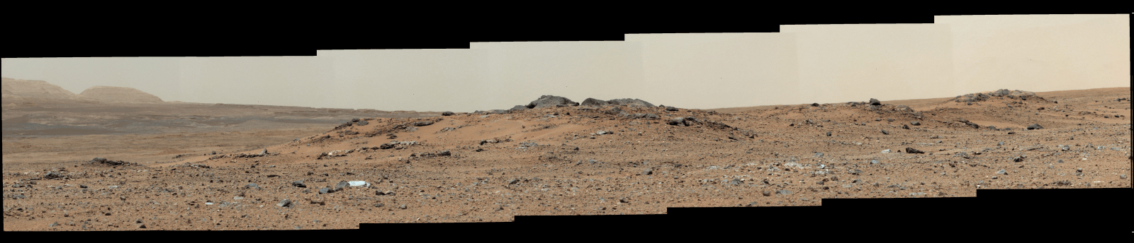
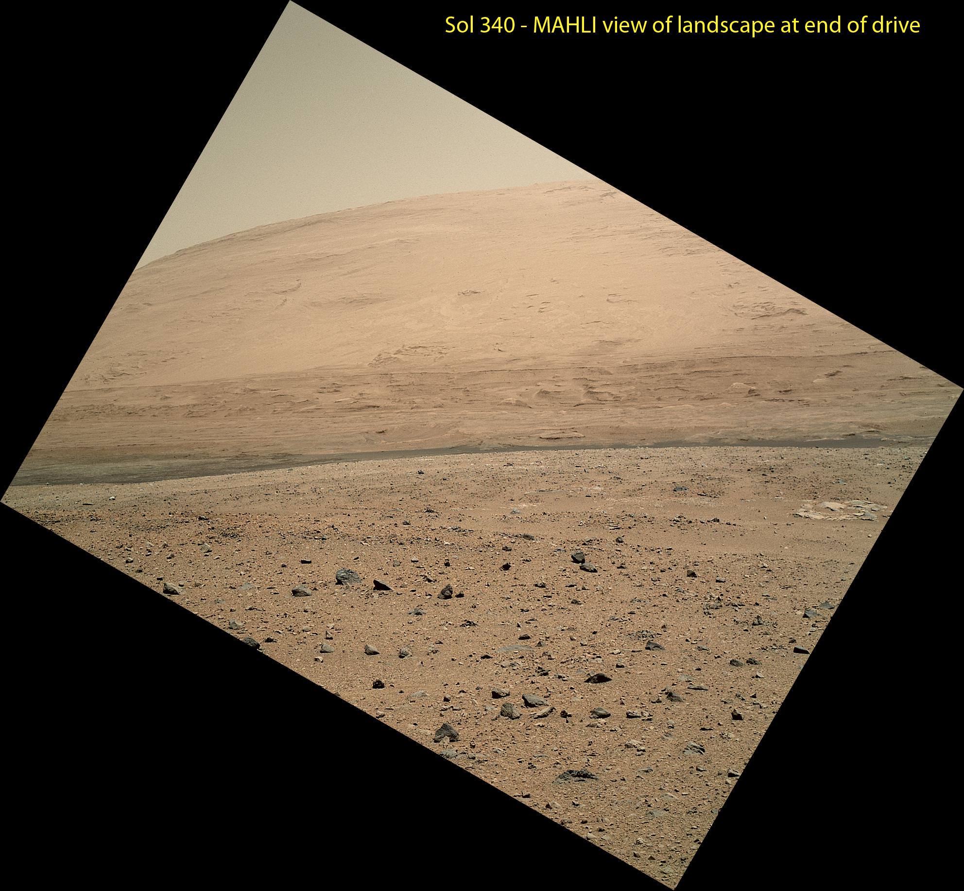
The scene taken on Sol 340 was taken shortly after Curiosity finished her longest yet. The 329.1-foot (100.3-meter) drive was twice as long as any previous sol's drive by Curiosity. The view is toward the south, including a portion of Mount Sharp and a band of dark dunes in front of the mountain. The Mars Hand Lens Imager (MAHLI) camera on NASA's Curiosity rover is carried at an angle when the rover's arm is stowed for driving. Still, the camera is able to record views of the terrain Curiosity is crossing in Gale Crater, and rotating the image 150 degrees provides this right-side-up scene. Credit: NASA/JPL-Caltech/MSSS
This scene was taken on Sol 340 shortly after Curiosity finished her longest drive yet
The 329.1-foot (100.3-meter) drive was twice as long as any previous sol’s drive by Curiosity. The view is toward the south, including a portion of Mount Sharp and a band of dark dunes in front of the mountain. The Mars Hand Lens Imager (MAHLI) camera on NASA’s Curiosity rover is carried at an angle when the rover’s arm is stowed for driving. Still, the camera is able to record views of the terrain Curiosity is crossing in Gale Crater, and rotating the image 150 degrees provides this right-side-up scene. Credit: NASA/JPL-Caltech/MSSS
See updated Traverse Map below[/caption]
NASA’s car-sized Curiosity rover is now blazing across the Red Planet’s surface and moving at a record setting pace towards a towering Martian mountain loaded with mineral caches that could potentially support a habitable environment.
On Sunday, July 21 (or Sol 340), Curiosity drove the length of a football field – 109.7 yards (100.3 meters) – a span that’s twice as far as she had ever driven before since the dramatic touch down on Mars nearly a year ago.
The previous record for a one-day drive was about half a football field – 54 yards (49 meters) – and achieved on Sol 50 (Sept. 26, 2012), roughly seven weeks after the pulse pounding landing inside Gale Crater on Aug. 6, 2012.
The 6 wheeled robot was able to move so far because on the prior drive she wound up atop a rise offering an uncommonly good view of the surrounding landscape and the road ahead across the crater floor towards Mount Sharp – the ultimate driving goal.
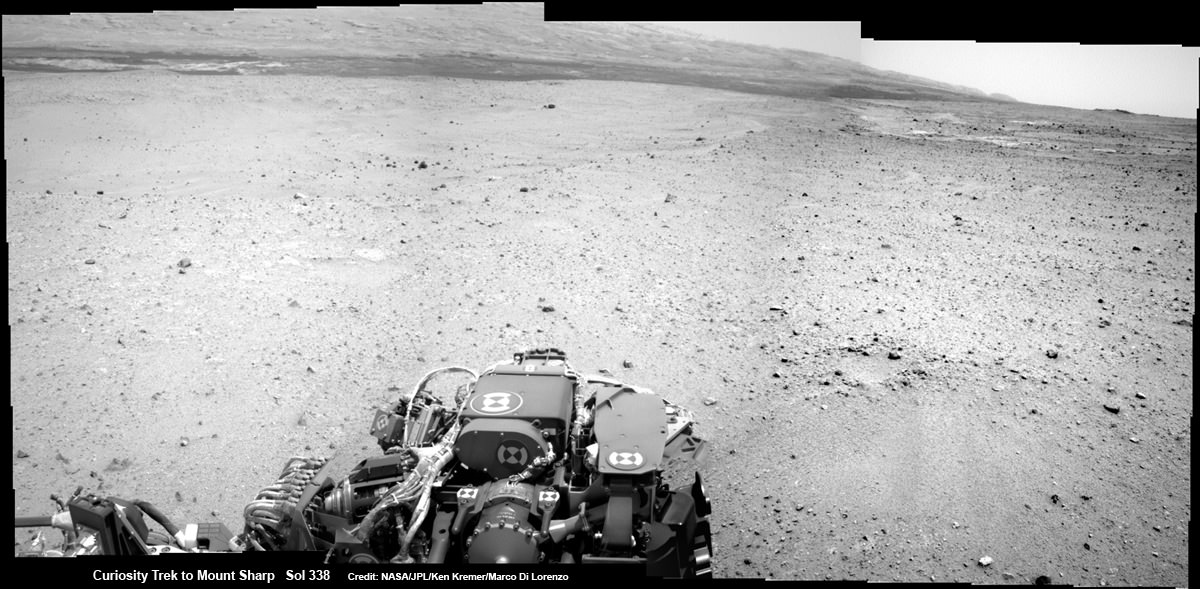
Curiosity On the Road to Mount Sharp and treacherous Sand Dunes – Sol 338 – July 19
Curiosity captured this panoramic view of the path ahead to the base of Mount Sharp and potentially dangerous sand dunes after a recent drive on July 19, 2013. She must safely cross over the dark dune field to climb and reach the lower sedimentary layers of Mount Sharp.
Credit: NASA/JPL-Caltech/Ken Kremer-(kenkremer.com)/Marco Di Lorenzo
“What enabled us to drive so far on Sol 340 was starting at a high point and also having Mastcam images giving us the size of rocks so we could be sure they were not hazards,” said rover planner Paolo Bellutta of NASA’s Jet Propulsion Laboratory, Pasadena, Calif, in a NASA statement.
“We could see for quite a distance, but there was an area straight ahead that was not clearly visible, so we had to find a path around that area.”
Following another lengthy drive of 68.2 yards (62.4 meters) on Wednesday, July 23 (Sol 342), the mission’s total driving distance so far stands at 0.81 mile (1.23 kilometers).
Mount Sharp lies about 5 miles (8 kilometers) distant – as the Martian crow flies.
On July 4, Curiosity embarked on the epic trek to Mount Sharp after completing more than seven months of science investigations and historic interplanetary drilling and sample analysis at an area known as Glenelg and Yellowknife Bay. There she discovered a habitable environment with the chemical ingredients that could sustain Martian microbes- thereby already accomplishing the primary goal of NASA’s flagship mission to Mars.
A combination of increased experience by the engineers directing the mega rover as well as intermediate software upgrades also play key roles in speeding Curiosity towards 3.4 mile (5.5 km) high Mount Sharp.
A huge leap in roving across Mars is in the works soon using new driving software called autonomous navigation, or autonav, that will hasten the overland journey.
“We have put some new software – called autonav, or autonomous navigation – on the vehicle right after the conjunction period back in March 2013,” said Jim Erickson, Curiosity Project Manager, in exclusive interview with Universe Today. Erickson is from NASA’s Jet Propulsion Laboratory (JPL) in Pasadena, Calif.
“This will increase our ability to drive.”
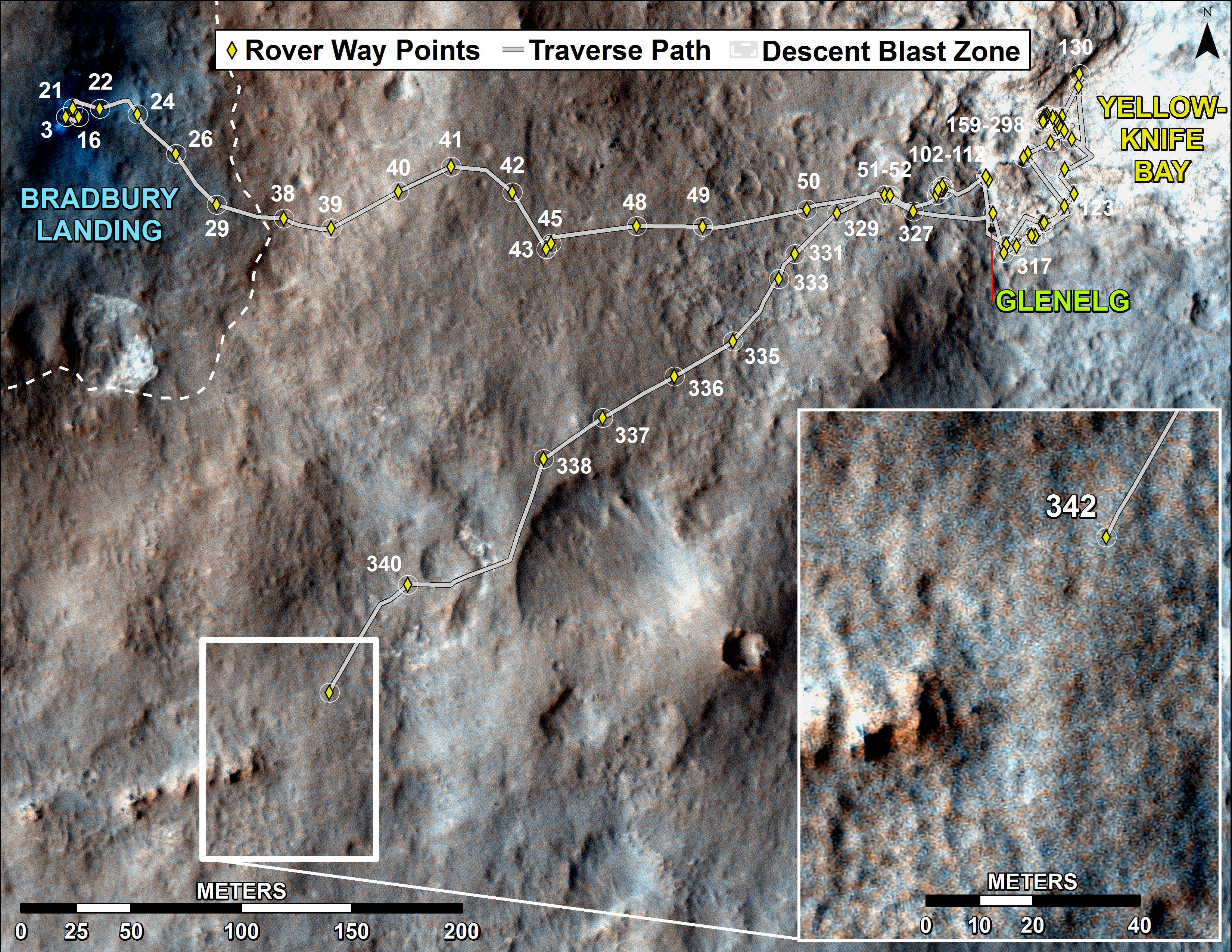
Curiosity’s Traverse Map Through Sol 342
This map shows the route driven by NASA’s Mars rover Curiosity through the 342 Martian day, or sol, of the rover’s mission on Mars (July 21, 2013). Numbering of the dots along the line indicate the sol number of each drive. North is up. The scale bar is 200 meters (656 feet). From Sol 340 to Sol 342, Curiosity had driven a straight line distance of about 191.9 feet (58.49 meters). The base image from the map is from the High Resolution Imaging Science Experiment Camera (HiRISE) in NASA’s Mars Reconnaissance Orbiter. Image Credit: NASA/JPL-Caltech/Univ. of Arizona
Implementing the new driving software will make Curiosity smarter as well as more capable, productive and independent than ever before.
“With autonav the rover will have the ability to understand how far it’s driving, whether its slipping or not, and it improves safety,” Erickson told me.
The rover’s route is on a southwestward heading towards the ancient sedimentary layers at the foothills of the mountain in the middle of Gale Crater.
In addition to setting new driving records, the 1 ton rover is also driving more frequently and on repeated days too.
When everything synchs up, Curiosity can drive two or more days in row.
“We can drive two days in a row now if the timing is right. If we get the results of the day’s drive (n) in time before we have to plan the next day’s drive (n+1) – almost as if you’re on Mars time. Then that would work fine,” Erickson explained.
“Also, when we get the autonav capability we can plan two days in row. One day of directed driving and the second day can be ‘OK here’s your target from wherever you end up, try and go to this spot’.”
“This will increase the productivity!”
Erickson says the team is testing autonav now and should it be up and running within weeks, or sooner.
Read Part 1 & Part 2 of my interview with Jim Erickson for further details.
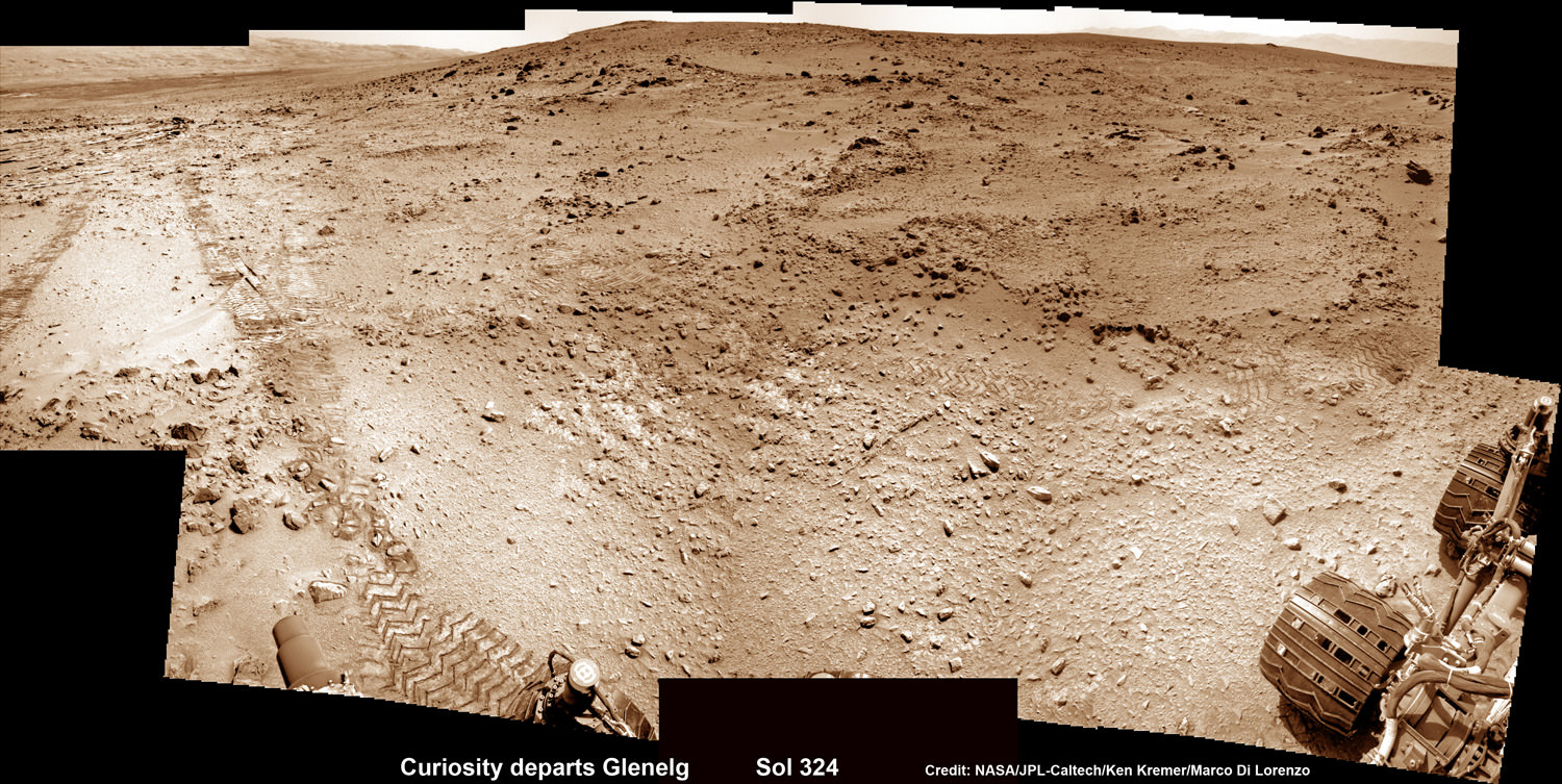
This photomosic shows NASA’s Curiosity departing at last for Mount Sharp- her main science destination. Note the wheel tracks on the Red Planet’s surface. The navcam camera images were taken on July 4, 2013 (Sol 324). Credit: NASA/JPL-Caltech/Ken Kremer (kenkremer.com)/Marco Di Lorenzo
Meanwhile Curiosity’s older sister rover Opportunity is making fast tracks towards her own mountain goal and should arrive at the base of Solander Point rather soon in August.
Solander Point is a segment of the eroded rim of huge Endeavour crater and may also possess key ingredients essential to support an environment favorable for possible Martian microbes.
And it’s worth noting that older sis Opportunity stills holds the 1 day Martian distance driving world record of 219.89 meters – established more than 8 years ago on Sol 410 (March 20, 2005)!!
Stay tuned for more on NASA’s sojourning pair of Martian robots.
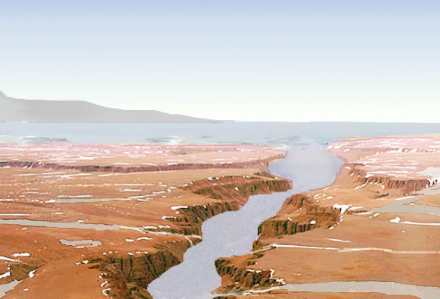
An artist's rendition of what water on Mars may have looked like. Source Credit: NASA
When it comes to Mars, the hot topic of study is water – a prerequisite for life.
While liquid water is currently not stable on the surface of Mars, there is extensive evidence that it may have been in the past. Astronomers have discovered dried up riverbeds, lake deltas, and evidence of widespread glaciers – to name but a few examples.
However, evidence for a massive standing body of water, such as an ocean, is hard to come by. Early climate models struggle to create circumstances under which liquid water would be stable at all. Nonetheless, an ocean spanning the northern lowlands (approximately one third of the planet) has been long hypothesized.
Scientists at Caltech may have just now confirmed this long-held hope in finding recent evidence for a vast Martian ocean.
The region under investigation is known as Aeolis Dorsa – a plain located at the border between the northern lowlands and the southern highlands. This plain contains many ridges, which are interpreted as ancient river channels.
“These ‘inverted’ channels are now elevated because the coarse sand and gravel carried by the channels is more resistant to erosion than the surrounding mud and silt making up the floodplain material,” Dr. Roman DiBiase, lead author on the study, told Universe Today.
Satellite images of Aeolis Dorsa were collected using the HiRISE camera aboard the Mars Reconnaissance Orbiter. The resolution was so precise scientists could distinguish features as small as 25 centimeters – an impressive feat even when compared to images of the Earth.
For certain locations “repeat pictures taken with a slight offset enable the creation of stereo-images from which we can determine the relative elevations of features on the planet’s surface,” explains DiBiase. This impressive technique led to high-resolution topographic models, allowing the team to analyze the geometry and patterns of these inverted channels in unprecedented detail.
Not only do the channels spread out toward the end, they also slope steeply downward, forming a delta – a sedimentary deposit that forms where rivers flow into lakes or oceans.
While deltas have been identified on Mars before, all lie within distinct topographic boundaries, such as an impact crater. This is the most compelling evidence for a delta leading into an unconfined region – an ocean.
Final proof of a Martian ocean will advance our knowledge of the intricate interplay between water, climate, and life. “The history of water on Mars has implications not only for the evolution of Martian climate, but also for learning about the early evolution of Earth and Earth’s climate,” explains DiBiase.
As always, further research is needed. Perhaps in the nearby future the Mars Reconnaissance Orbiter and Curiosity will compliment each other quite well – the orbiter taking images from above while Curiosity plays in the dirt, gathering samples in the riverbed.
The study was published in the Journal of Geophysical Research and may be found here.