This figure from new research shows an unnamed river valley network on Mars. By dating the craters in the image, a researcher at the Planetary Science Institute was able to determine when the river channels were formed. Image Credit: MOLA MEGDR, NASA/USGS; THEMIS mosaic, ASU/NASA/USGS; CTX, NASA/MSSS.
There’s overwhelming evidence that Mars was once wet and warm. Rivers flowed across its surface and carved intricate channel systems revealed by our orbiters. Expansive oceans even larger than Earth’s may have covered a third of its surface. Then something happened: Mars lost its atmosphere, cooled down, and surface water disappeared.
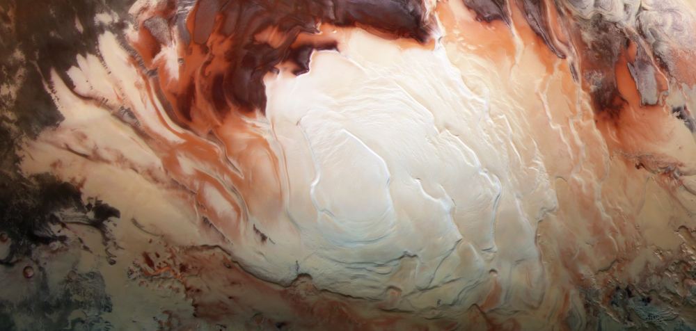
Ice at Mars' south pole. Image Credit: ESA/DLR/FU Berlin/Bill Dunford
Is Mars home to an underwater lake? Different researchers are reaching different conclusions. Some say remote sensing from the Mars Express orbiter shows liquid water in an underground lake at Mars’ south polar region. Other researchers say clays or minerals explain the data better.
Who’s right? Maybe none of them.
A new study says that volcanic rock can explain the Mars Express data and that it’s a more plausible explanation.
Water ice, especially any located in the sub-surface, has long been a focal point of Mars exploration efforts. Reasons abound as to why – from the need to grow plants to the need to create more rocket fuel to blast off the planet for a round trip. Most of that effort has focused on the poles of the planet, where most of the water ice has been found.
Artist’s impression of a massive asteroid belt in orbit around a star. Earth's water may not have all come from asteroids and comets, so maybe that's true for exoplanets. Credit: NASA-JPL / Caltech / T. Pyle (SSC)
If you asked someone who was reasonably scientifically literate how Earth got its water, they’d likely tell you it came from asteroids—or maybe comets and planetesimals, too—that crashed into our planet in its early days. There’s detail, nuance, and uncertainty around that idea, but it’s widely believed to be the most likely reason that Earth has so much water.
But a new explanation for Earth’s water is emerging. It says that the water comes along for the ride when Earth formed out of the solar nebula.
If that’s correct, it means that most rocky planets might have water for at least a portion of their lives.
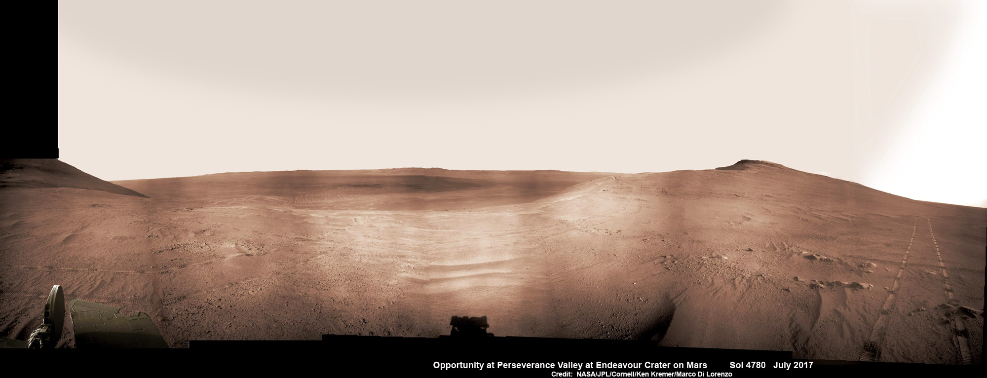
Historic 1st descent down Martian gully. Panoramic view looking down Perseverance Valley after entry at top was acquired by NASA’s Opportunity rover scanning from north to south. It shows numerous wheel tracks at left, center and right as rover conducted walkabout tour prior to starting historic first decent down a Martian gully - possibly carved by water - and looks into the interior of Endeavour crater. Perseverance Valley terminates down near the crater floor in the center of the panorama. The far rim of Endeavour crater is seen in the distance, beyond the dark floor. Rover mast shadow at center and deck at left. This navcam camera photo mosaic was assembled by Ken Kremer and Marco Di Lorenzo from raw images taken on Sol 4780 (5 July 2017) and colorized. Credit: NASA/JPL/Cornell/Ken Kremer/kenkremer.com/Marco Di Lorenzo
Historic 1st descent down Martian gully. Panoramic view looking down Perseverance Valley after entry at top was acquired by NASA’s Opportunity rover scanning from north to south. It shows numerous wheel tracks at left, center and right as rover conducted walkabout tour prior to starting historic first decent down a Martian gully – possibly carved by water – and looks into the interior of Endeavour crater. Perseverance Valley terminates down near the crater floor in the center of the panorama. The far rim of Endeavour crater is seen in the distance, beyond the dark floor. Rover mast shadow at center and deck at left. This navcam camera photo mosaic was assembled by Ken Kremer and Marco Di Lorenzo from raw images taken on Sol 4780 (5 July 2017) and colorized. Credit: NASA/JPL/Cornell/Ken Kremer/kenkremer.com/Marco Di Lorenzo
From the precipice of “Perseverance Valley” NASA’s teenaged Red Planet robot Opportunity has begun the historic first ever descent of an ancient Martian gully – that’s simultaneously visually and scientifically “tantalizing” – on an expedition to discern ‘How was it carved?’; by water or other means, Jim Green, NASA’s Planetary Sciences Chief tells Universe Today.
Since water is an indispensable ingredient for life as we know it, the ‘opportunity’ for Opportunity to study a “possibly water-cut” gully on Mars for the first time since they were discovered over four decades ago by NASA orbiters offers a potential scientific bonanza.
“Gullies on Mars have always been of intense interest since first observed by our orbiters,” Jim Green, NASA’s Planetary Sciences Chief explained to Universe Today.
“How were they carved? muses Green. “Water is a natural explanation but this is another planet. Now we have a chance to find out for real!”
Their origin and nature has been intensely debated by researchers for decades. But until now the ability to gather real ‘ground truth’ science by robotic or human explorers has remained elusive.
“This will be the first time we will acquire ground truth on a gully system that just might be formed by fluvial processes,” Ray Arvidson, Opportunity Deputy Principal Investigator of Washington University in St. Louis, told Universe Today.
“Perseverance Valley” is located along the eroded western rim of gigantic Endeavour crater – as illustrated by our exclusive photo mosaics herein created by the imaging team of Ken Kremer and Marco Di Lorenzo.
After arriving at the upper entryway to “Perseverance Valley” the six wheeled rover drove back and forth to gather high resolution imagery of the inner slope for engineers to create a 3D elevation map and plot a safe driving path down – as illustrated in our lead mosaic showing the valley and extensive wheel tracks at left, center and right.
Having just this week notched an astounding 4800 Sols roving the Red Planet, NASA’s resilient Opportunity rover has started driving down from the top of “Perseverance Valley” from the spillway overlooking the upper end of the ancient fluid-carved Martian valley into the unimaginably vast eeriness of alien Endeavour crater.
Water, ice or wind may have flowed over the crater rim and into the crater from the spillway.
“It is a tantalizing scene,” said Opportunity Deputy Principal Investigator Ray Arvidson of Washington University in St. Louis, in a statement. “You can see what appear to be channels lined by boulders, and the putative spillway at the top of Perseverance Valley. We have not ruled out any of the possibilities of water, ice or wind being responsible.”
Toward the right side of this scene is a broad notch in the crest of the western rim of Endeavour Crater. Wheel tracks in that area were left by NASA’s Mars Exploration Rover Opportunity as it observed “Perseverance Valley” from above in the spring of 2017. The valley is a major destination for the rover’s extended mission. It descends out of sight on the inner slope of the rim, extending down and eastward from that notch. The component pancam images for this view from a position outside the crater were taken during the span of June 7 to June 19, 2017, sols 4753 to 4765. Credit: NASA/JPL-Caltech/Cornell/Arizona State Univ.
“With the latest drive on sol 4782, Opportunity began the long drive down the floor of Perseverance Valley here on Endeavour crater, says Larry Crumpler, a rover science team member from the New Mexico Museum of Natural History & Science.
“This is rather historic in that it represents the first time that a rover has driven down an apparent water-cut valley on Mars. Over the next few months Opportunity will explore the floor and sides of the valley for evidence of the scale and timing of the fluvial activity, if that is what is represents.”
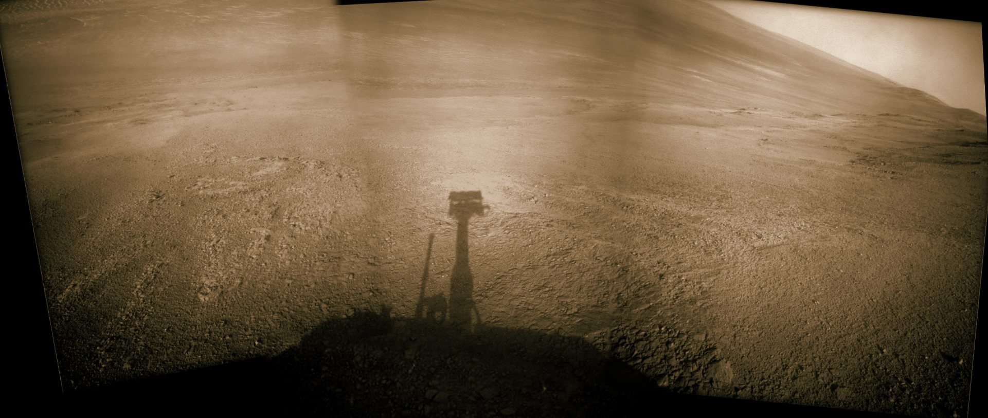
This mosaic view looks down from inside the upper end of “Perseverance Valley” on the inner slope of Endeavour Crater’s western rim after Opportunity started driving down the Martian gully. The scene behind the shadow of the rover’s mast shows Perseverance Valley descending to the floor of Endeavour Crater. This navcam camera photo mosaic was assembled from raw images taken on Sol 4782 (7 July 2017) and colorized. Credit: NASA/JPL/Cornell/Marco Di Lorenzo/Ken Kremer/kenkremer.com
NASA’s unbelievably long lived Martian robot reached a “spillway” at the top of “Perseverance Valley” in May after driving southwards for weeks from the prior science campaign at a crater rim segment called “Cape Tribulation.”
“Investigations in the coming weeks will “endeavor” to determine whether this valley was eroded by water or some other dry process like debris flows,” explains Crumpler.
“It certainly looks like a water cut valley. But looks aren’t good enough. We need additional evidence to test that idea.”
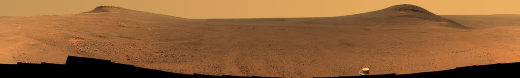
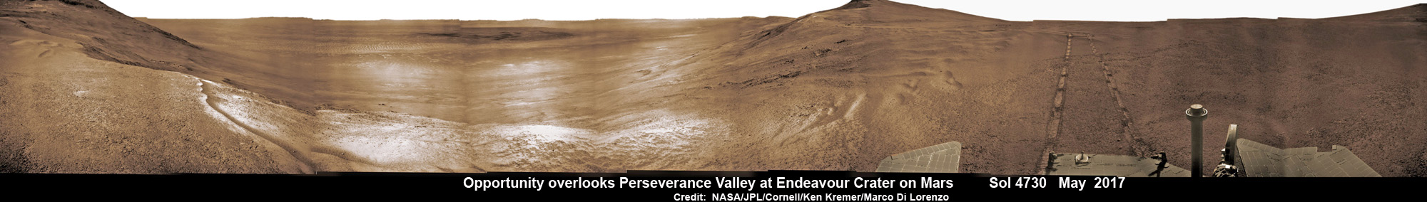
NASA’s Opportunity rover acquired this Martian panoramic view from a promontory that overlooks Perseverance Valley below – scanning from north to south. It is centered on due East and into the interior of Endeavour crater. Perseverance Valley descends from the right and terminates down near the crater floor in the center of the panorama. The far rim of Endeavour crater is seen in the distance, beyond the dark floor. Rover deck and wheel tracks at right. This navcam camera photo mosaic was assembled from raw images taken on Sol 4730 (14 May 2017) and colorized. Credit: NASA/JPL/Cornell/Ken Kremer/kenkremer.com/Marco Di Lorenzo
The valley slices downward from the crest line through the rim from west to east at a breathtaking slope of about 15 to 17 degrees – and measures about two football fields in length!
Huge Endeavour crater spans some 22 kilometers (14 miles) in diameter on the Red Planet. Perseverance Valley slices eastwards at approximately the 8 o’clock position of the circular shaped crater. It sits just north of a rim segment called “Cape Byron.”
Why go and explore the gully at Perseverance Valley?
“Opportunity will traverse to the head of the gully system [at Perseverance] and head downhill into one or more of the gullies to characterize the morphology and search for evidence of deposits,” Arvidson elaborated to Universe Today.
“Hopefully test among dry mass movements, debris flow, and fluvial processes for gully formation. The importance is that this will be the first time we will acquire ground truth on a gully system that just might be formed by fluvial processes. Will search for cross bedding, gravel beds, fining or coarsening upward sequences, etc., to test among hypotheses.”
Exploring the ancient valley is the main science destination of the current two-year extended mission (EM #10) for the teenaged robot, that officially began Oct. 1, 2016. It’s just the latest in a series of extensions going back to the end of Opportunity’s prime mission in April 2004.
Before starting the gully descent, Opportunity conducted a walkabout at the top of the Perseverance Valley in the spillway to learn more about the region before driving down.
“The walkabout is designed to look at what’s just above Perseverance Valley,” said Opportunity Deputy Principal Investigator Ray Arvidson of Washington University in St. Louis, in a statwemwent. “We see a pattern of striations running east-west outside the crest of the rim.”
“We want to determine whether these are in-place rocks or transported rocks,” Arvidson said. “One possibility is that this site was the end of a catchment where a lake was perched against the outside of the crater rim. A flood might have brought in the rocks, breached the rim and overflowed into the crater, carving the valley down the inner side of the rim. Another possibility is that the area was fractured by the impact that created Endeavour Crater, then rock dikes filled the fractures, and we’re seeing effects of wind erosion on those filled fractures.”
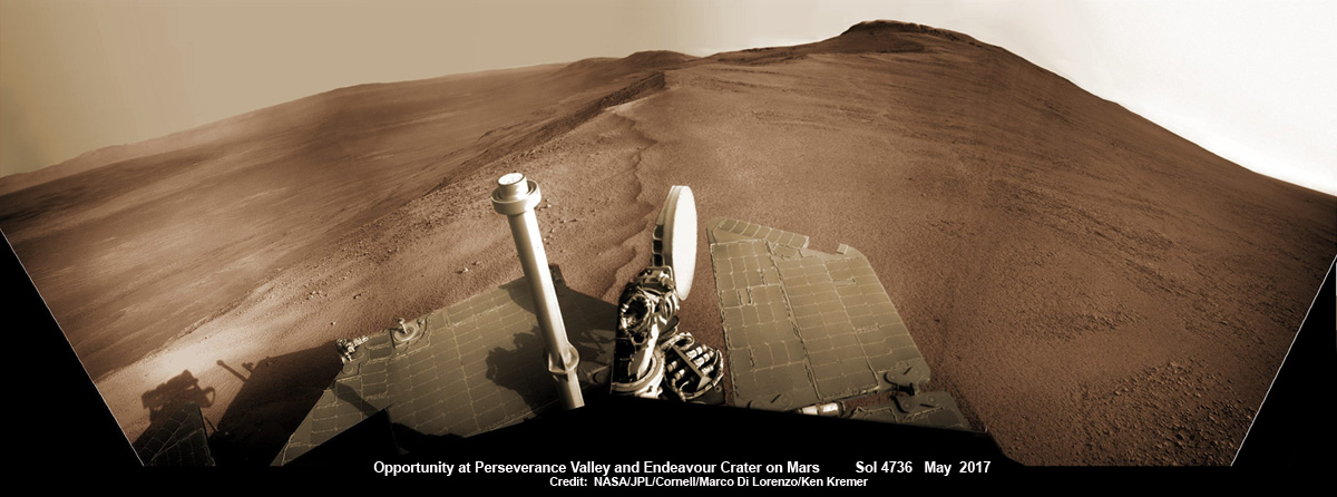
Opportunity rover looks south from the top of Perseverance Valley along the rim of Endeavour Crater on Mars in this partial self portrait including the rover deck and solar panels. Perseverance Valley descends from the right and terminates down near the crater floor. This navcam camera photo mosaic was assembled from raw images taken on Sol 4736 (20 May 2017) and colorized. Credit: NASA/JPL/Cornell/Marco Di Lorenzo/Ken Kremer/kenkremer.com
Having begun the long awaited gully descent, further movements are temporarily on hold since the start of the solar conjunction period which blocks communications between Mars and Earth for about the next two weeks, since Mars is directly behind the sun.
In the meantime, Opportunity will still collect very useful panoramic images and science data while standing still.
The solar conjunction moratorium on commanding extends from July 22 to Aug. 1, 2017.
As of today, July 27, 2017, long lived Opportunity has survived over 4800 Sols (or Martian days) roving the harsh environment of the Red Planet.
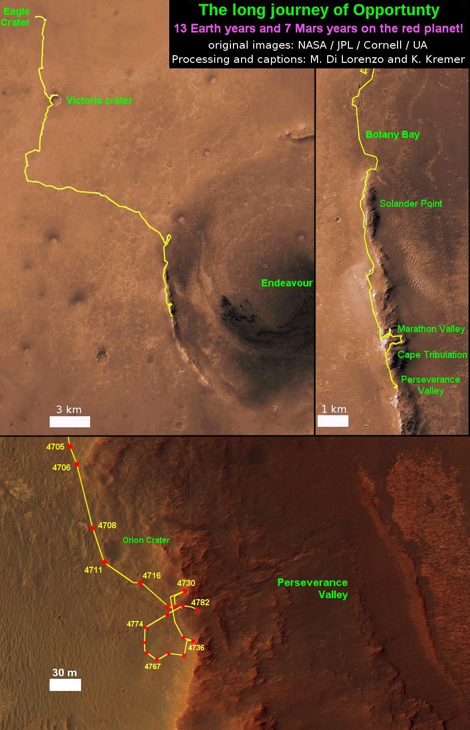
Opportunity has taken over 221,625 images and traversed over 27.95 miles (44.97 kilometers.- more than a marathon.
See our updated route map below. It shows the context of the rovers over 13 year long traverse spanning more than the 26 mile distance of a Marathon runners race.
The rover surpassed the 27 mile mark milestone on November 6, 2016 (Sol 4546) and will soon surpass the 28 mile mark.
As of Sol 4793 (July 18, 2017) the power output from solar array energy production is currently 332 watt-hours with an atmospheric opacity (Tau) of 0.774 and a solar array dust factor of 0.534, before heading into another southern hemisphere Martian winter later in 2017. It will count as Opportunity’s 8th winter on Mars.
Meanwhile Opportunity’s younger sister rover Curiosity traverses up the lower sedimentary layers at the base of Mount Sharp.
And NASA continues building the next two robotic missions due to touch down in 2018 and 2020.
NASA as well is focusing its human spaceflight efforts on sending humans on a ‘Journey to Mars’ in the 2030s with the Space Launch System (SLS) mega rocket and Orion deep space crew capsule.
Stay tuned here for Ken’s continuing Earth and planetary science and human spaceflight news.
13 Year Traverse Map for NASA’s Opportunity rover from 2004 to 2017. This map shows the entire 43 kilometer (27 mi) path the rover has driven on the Red Planet during over 13 years and more than a marathon runners distance for over 4782 Sols, or Martian days, since landing inside Eagle Crater on Jan 24, 2004 – to current location at the western rim of Endeavour Crater. After studying Spirit Mound and ascending back uphill the rover has reached her next destination in May 2017- the Martian water carved gully at Perseverance Valley near Orion crater. Rover surpassed Marathon distance on Sol 3968 after reaching 11th Martian anniversary on Sol 3911. Opportunity discovered clay minerals at Esperance – indicative of a habitable zone – and searched for more at Marathon Valley. Credit: NASA/JPL/Cornell/ASU/Marco Di Lorenzo/Ken Kremer/kenkremer.com
Star Trek actor LeVar Burton Shares MAVEN’s Story in a New NASA public service announcement (PSA). Credit: NASA
Star Trek actor LeVar Burton Shares MAVEN’s Story in a New NASA public service announcement (PSA). Credit: NASA
Watch the PSA below[/caption]
KENNEDY SPACE CENTER, FL – Star Trek actor and space enthusiast LeVar Burton stars in a new action packed NASA public service announcement (PSA) about the agency’s next Mars-bound spacecraft, the Mars Atmosphere and Volatile Evolution (MAVEN) spacecraft slated for blast off in barely two days time on Nov. 18 from the Florida Space Coast.
Burton played the beloved character of chief engineer ‘Geordi LeForge’ aboard the legendary Starship Enterprise on “Star Trek: The Next Generation” – known by audiences worldwide.
And Burton gives an appropriately other worldly narration in the NASA PSA containing exciting new animations explaining the goals and science behind the MAVEN Mars orbiter and how it will accomplish its tasks.
I was privileged to meet chief engineer ‘Geordi LeForge’ at a prior NASA launch event.
He is genuinely and truly dedicated to advancing science and education through his many STEM initiatives and participation in educational programming like the NASA PSA.
MAVEN will study the Red Planet’s atmosphere like never before and in unprecedented detail and is the first mission dedicated to studying Mars upper atmosphere.
MAVEN’s is aimed at unlocking one of the greatest Martian mysteries; Where did all the water go ? And when did the Red Planet’s water and atmosphere disappear ?
MAVEN’s suite of nine science instruments will help scientists understand the history, mechanism and causes of the Red Planet’s dramatic climate change over billions of years.
Burton’s PSA will be used at MAVEN scheduled events around the country and will also be shared on the web and social media, according to NASA. The goal is to educate the public about MAVEN and NASA’s efforts to better understand the Red Planet and the history of climate change there.
Be sure to check out the new video – below:
Video caption: NASA is returning to Mars! This NASA Public Service Announcement regarding the MAVEN mission is presented by LeVar Burton in which he shares the story about NASA’s Mars Atmosphere and Volatile Evolution mission—or MAVEN—and how it will explore Mars’ climate history and gather clues about the question scientists have been asking for decades. MAVEN will look at specific processes at Mars that led to the loss of much of its atmosphere…and MAVEN data could tell scientists a lot about the history of climate change on the Red Planet.
“NASA is thrilled to have LeVar Burton explain this mission to the greater public,” said Bert Ulrich, NASA’s multimedia liaison for film and TV collaborations in a NASA statement. “Thanks to Burton’s engaging talents and passion for space exploration, audiences of all ages will be able to share in the excitement of NASA’s next mission to Mars.”
MAVEN is targeted to launch Monday, Nov. 18 at 1:28 p.m. EST atop a United Launch Alliance Atlas V rocket from Cape Canaveral Air Force Station in Florida.
You can watch the launch live on NASA TV
Stay tuned here for continuing MAVEN and MOM news and Ken’s MAVEN launch reports from on site at the Kennedy Space Center press site.
Learn more about MAVEN, MOM, Mars rovers, Orion and more at Ken’s upcoming presentations
Nov 15-20: “MAVEN Mars Launch and Curiosity Explores Mars, Orion and NASA’s Future”, Kennedy Space Center Quality Inn, Titusville, FL, 8 PM
Dec 11: “Curiosity, MAVEN and the Search for Life on Mars”, “LADEE & Antares ISS Launches from Virginia”, Rittenhouse Astronomical Society, Franklin Institute, Phila, PA, 8 PM
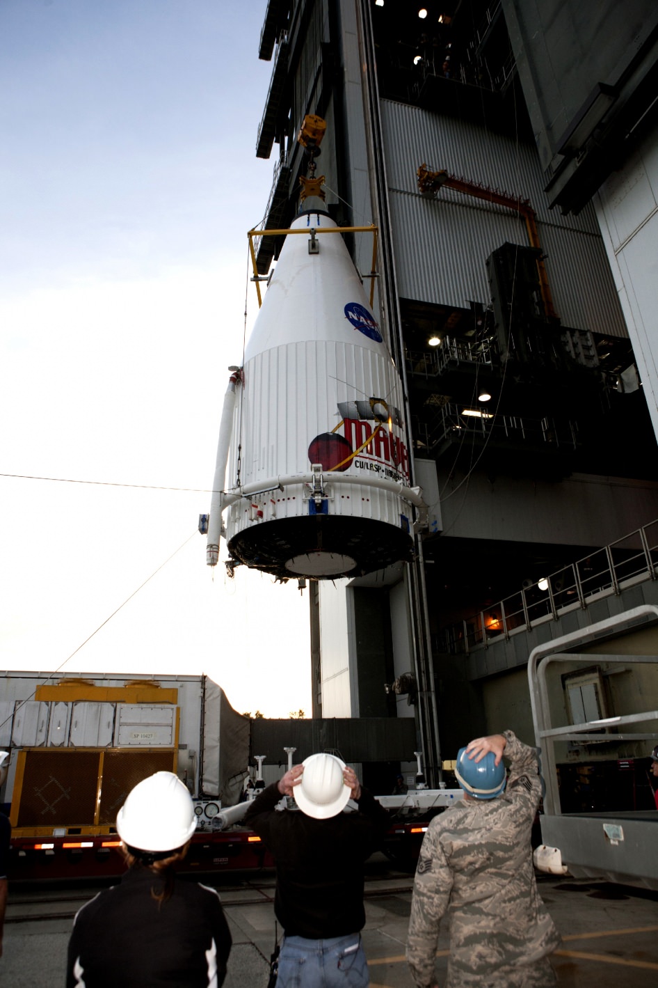
Inside the Payload Hazardous Servicing Facility at NASA's Kennedy Space Center in Florida, engineers and technicians prepare the MAVEN spacecraft for encapsulation inside its payload fairing. Credit: NASA/Kim Shiflett
KENNEDY SPACE CENTER, FL – MAVEN, NASA’s next spacecraft launching to the Red Planet in barely three days time on Nov. 18 seeks to unlock one of the greatest Martian mysteries; Where did all the water go ?
From the accumulated evidence so far scientists believe that billions of years ago, Mars was gifted with a thick atmosphere like Earth and liquid water flowed across the surface.
The Red Planet was far bluer, warmer, wetter and hospitable to life four billion years ago – truly a lot more Earth-like.
And then Mars lost its atmosphere starting somewhere around 3.5 to 3.7 Billion years ago. As the atmosphere thinned and the pressure decreased, the water evaporated and Mars evolved into the cold arid world we know today.
But why and exactly when did Mars undergo such a radical climatic transformation?
“Where did the water go and where did the carbon dioxide go from the early atmosphere? What were the mechanisms?” asks Bruce Jakosky, MAVEN’s Principal Investigator from the University of Colorado at Boulder
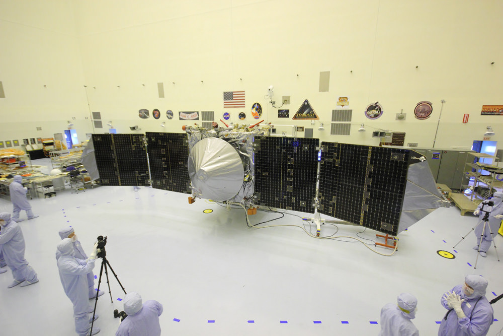
MAVEN is NASA’s next Mars orbiter and is due to blastoff on Nov. 18 from Cape Canaveral, Florida. It will study the evolution of the Red Planet’s atmosphere and climate. Universe Today visited MAVEN inside the clean room at the Kennedy Space Center. With solar panels unfurled, this is exactly how MAVEN looks when flying through space and circling Mars. Credit: Ken Kremer/kenkremer.com
Although there are lots of theories, NASA’s MAVEN Mars orbiter – which stands for Mars Atmosphere and Volatile Evolution – is the first real attempt to investigating these fundamental questions that hold the key to solving the Martian mysteries perplexing the science community.
“We don’t know the driver of the change,” explains Jakosky.
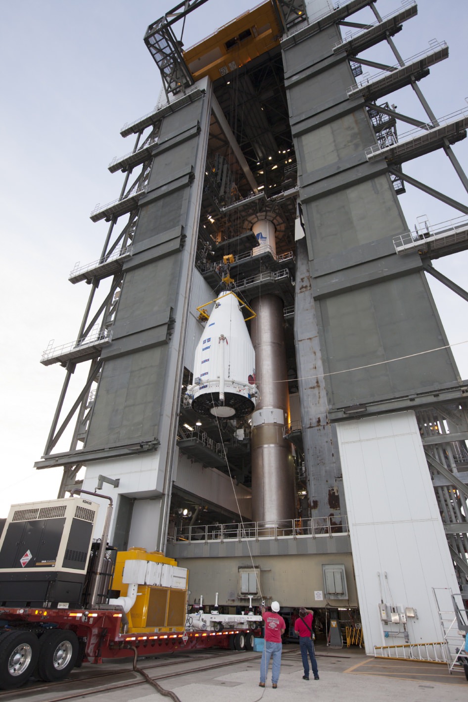
MAVEN Mated to Atlas. On Nov. 8,2013, NASA’s Mars Atmosphere and Volatile Evolution, or MAVEN spacecraft, is hoisted to the top of a United Launch Alliance Atlas V rocket at the Vertical Integration Facility at Launch Complex 41. Credit: NASA/Kim ShiflettBy studying and understanding specific processes in the upper atmosphere of Mars, MAVEN’s seeks to determine how and why Mars atmosphere and water disappeared billions of years ago and what effect that had on the history of climate change and habitability.
“The major questions about the history of Mars center on the history of its climate and atmosphere and how that’s influenced the surface, geology and the possibility for life,” says Jakosky.
MAVEN is equipped with three instrument suites holding nine science instruments
MAVEN will focus on understanding the history of the atmosphere, how the climate has changed through time, and how that influenced the evolution of the surface and the potential for habitability by microbes on Mars.”
“That’s what driving our exploration of Mars with MAVEN,” said Jakosky
The 5,400 pound MAVEN probe carries nine sensors in three instrument suites.
MAVEN Spacecraft Positioned Atop Atlas V Rocket at Launch Complex 41 on Cape Canaveral. Credit: NASAThe Particles and Fields Package, provided by the University of California at Berkeley with support from CU/LASP and NASA’s Goddard Space Flight Center in Greenbelt, Md., contains six instruments to characterize the solar wind and the ionosphere of Mars. The Remote Sensing Package, built by CU/LASP, will determine global characteristics of the upper atmosphere and ionosphere. The Neutral Gas and Ion Mass Spectrometer, built by Goddard, will measure the composition of Mars’ upper atmosphere.
I personally inspected MAVEN inside the clean room at the Kennedy Space Center on Sept. 27 with fellow journalists when the solar arrays were fully unfurled.
The probe spanned 37 feet in length from wingtip to wingtip.
Since then MAVEN has been folded and encapsulated inside the payload fairing, transported to the pad at Launch Complex 41 and hoisted on top of the Atlas V rocket on Cape Canaveral Air Force Station (CCAFS) in Florida.
The $671 Million MAVEN spacecraft has been powered on and awaits liftoff.
MAVEN is the second of two Mars bound probes launching from Earth this November.
Learn more about MAVEN, MOM, Mars rovers, Orion and more at Ken’s upcoming presentations
Nov 14-20: “MAVEN Mars Launch and Curiosity Explores Mars, Orion and NASA’s Future”, Kennedy Space Center Quality Inn, Titusville, FL, 8 PM
Dec 11: “Curiosity, MAVEN and the Search for Life on Mars”, “LADEE & Antares ISS Launches from Virginia”, Rittenhouse Astronomical Society, Franklin Institute, Phila, PA, 8 PM