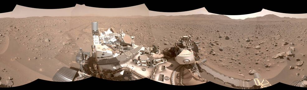
This image mosaic shows Perseverance's tracks as it made its way through a boulder field called "Snowdrift Peak." The rover's advanced autonomous navigation system guided the machine through the hazardous area in record time. Image Credit: NASA/JPL-Caltech
NASA’s Perseverance Rover has been exploring Mars for more than 900 sols. It’s the most scientifically advanced rover ever built and has opened our eyes wider to Mars and the possibility that it hosted life. The rover’s crowning achievement is preparing samples for eventual return to Earth, an important next step in understanding Mars.
But it can’t do any of its work without moving effectively and efficiently on the Martian surface. And in this regard, Perseverance and its autopilot are setting some serious records.
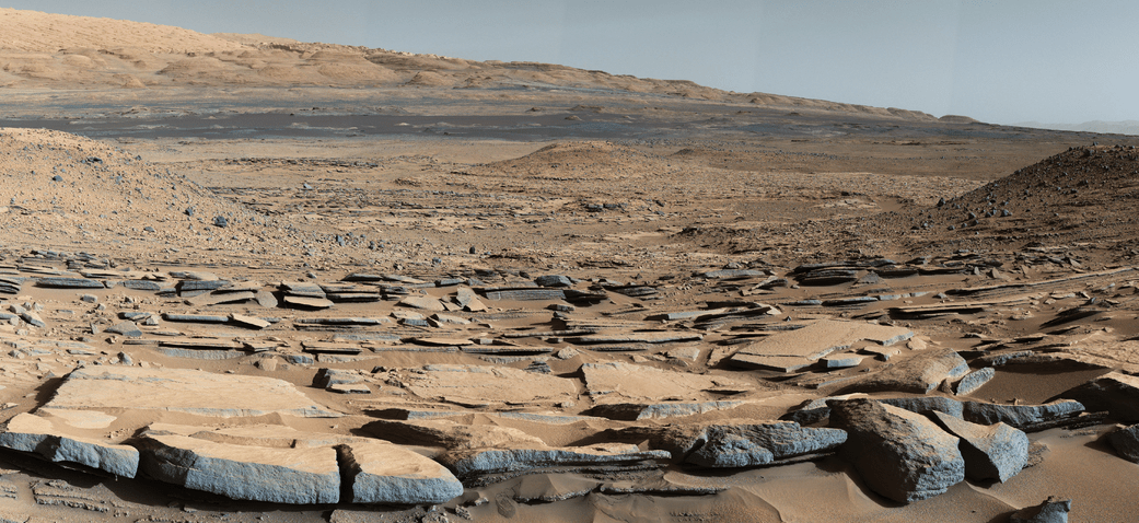
A view from the "Kimberley" formation on Mars taken by NASA's Curiosity rover. The strata in the foreground dip towards the base of Mount Sharp, indicating flow of water toward a basin that existed before the larger bulk of the mountain formed. This image was taken by the Mast Camera (Mastcam) on Curiosity on Sol 580 of the mission and has been “white balanced” to adjust for the lighting on Mars make the sky appear light blue. Credits: NASA/JPL-Caltech/MSSS
It’s all about the detail.
In a way, Mars looks like a dusty, dead, dry, boring planet. But science says otherwise. Science says that Mars used to be wet and warm, with an atmosphere. And science says that it was wet and warm for billions of years, easily long enough for life to appear and develop.
But we still don’t know for sure if any life did happen there.
Special Guests:
This week we are excited to welcome Emily Lakdawalla, Senior Editor and Planetary Evangelist at The Planetary Society, back to the Weekly Space Hangout. On On May 14th, Emily’s new book, The Design and Engineering of Curiosity: How the Mars Rover Performs Its Job, will be released. It in, Emily describes the engineering that went into each instrument and piece of machinery incorporated into Curiosity’s systems. You can learn more about the book and Emily’s planned followup book on her blog here: http://www.planetary.org/blogs/emily-lakdawalla/2017/0831-book-update.html
Announcements:
If you would like to join the Weekly Space Hangout Crew, visit their site here and sign up. They’re a great team who can help you join our online discussions!
We record the Weekly Space Hangout every Wednesday at 5:00 pm Pacific / 8:00 pm Eastern. You can watch us live on Universe Today, or the Weekly Space Hangout YouTube page – Please subscribe!
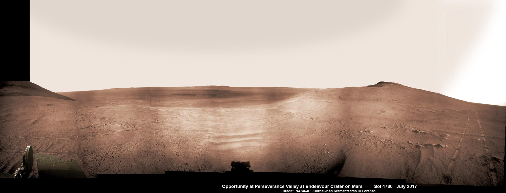
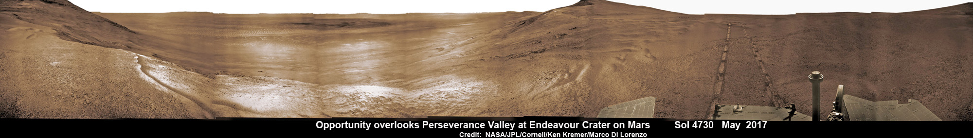
Historic 1st descent down Martian gully. Panoramic view looking down Perseverance Valley after entry at top was acquired by NASA’s Opportunity rover scanning from north to south. It shows numerous wheel tracks at left, center and right as rover conducted walkabout tour prior to starting historic first decent down a Martian gully - possibly carved by water - and looks into the interior of Endeavour crater. Perseverance Valley terminates down near the crater floor in the center of the panorama. The far rim of Endeavour crater is seen in the distance, beyond the dark floor. Rover mast shadow at center and deck at left. This navcam camera photo mosaic was assembled by Ken Kremer and Marco Di Lorenzo from raw images taken on Sol 4780 (5 July 2017) and colorized. Credit: NASA/JPL/Cornell/Ken Kremer/kenkremer.com/Marco Di Lorenzo
Historic 1st descent down Martian gully. Panoramic view looking down Perseverance Valley after entry at top was acquired by NASA’s Opportunity rover scanning from north to south. It shows numerous wheel tracks at left, center and right as rover conducted walkabout tour prior to starting historic first decent down a Martian gully – possibly carved by water – and looks into the interior of Endeavour crater. Perseverance Valley terminates down near the crater floor in the center of the panorama. The far rim of Endeavour crater is seen in the distance, beyond the dark floor. Rover mast shadow at center and deck at left. This navcam camera photo mosaic was assembled by Ken Kremer and Marco Di Lorenzo from raw images taken on Sol 4780 (5 July 2017) and colorized. Credit: NASA/JPL/Cornell/Ken Kremer/kenkremer.com/Marco Di Lorenzo
From the precipice of “Perseverance Valley” NASA’s teenaged Red Planet robot Opportunity has begun the historic first ever descent of an ancient Martian gully – that’s simultaneously visually and scientifically “tantalizing” – on an expedition to discern ‘How was it carved?’; by water or other means, Jim Green, NASA’s Planetary Sciences Chief tells Universe Today.
Since water is an indispensable ingredient for life as we know it, the ‘opportunity’ for Opportunity to study a “possibly water-cut” gully on Mars for the first time since they were discovered over four decades ago by NASA orbiters offers a potential scientific bonanza.
“Gullies on Mars have always been of intense interest since first observed by our orbiters,” Jim Green, NASA’s Planetary Sciences Chief explained to Universe Today.
“How were they carved? muses Green. “Water is a natural explanation but this is another planet. Now we have a chance to find out for real!”
Their origin and nature has been intensely debated by researchers for decades. But until now the ability to gather real ‘ground truth’ science by robotic or human explorers has remained elusive.
“This will be the first time we will acquire ground truth on a gully system that just might be formed by fluvial processes,” Ray Arvidson, Opportunity Deputy Principal Investigator of Washington University in St. Louis, told Universe Today.
“Perseverance Valley” is located along the eroded western rim of gigantic Endeavour crater – as illustrated by our exclusive photo mosaics herein created by the imaging team of Ken Kremer and Marco Di Lorenzo.
After arriving at the upper entryway to “Perseverance Valley” the six wheeled rover drove back and forth to gather high resolution imagery of the inner slope for engineers to create a 3D elevation map and plot a safe driving path down – as illustrated in our lead mosaic showing the valley and extensive wheel tracks at left, center and right.
Having just this week notched an astounding 4800 Sols roving the Red Planet, NASA’s resilient Opportunity rover has started driving down from the top of “Perseverance Valley” from the spillway overlooking the upper end of the ancient fluid-carved Martian valley into the unimaginably vast eeriness of alien Endeavour crater.
Water, ice or wind may have flowed over the crater rim and into the crater from the spillway.
“It is a tantalizing scene,” said Opportunity Deputy Principal Investigator Ray Arvidson of Washington University in St. Louis, in a statement. “You can see what appear to be channels lined by boulders, and the putative spillway at the top of Perseverance Valley. We have not ruled out any of the possibilities of water, ice or wind being responsible.”
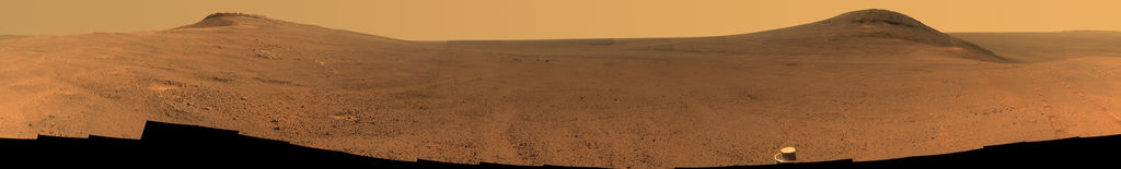
Toward the right side of this scene is a broad notch in the crest of the western rim of Endeavour Crater. Wheel tracks in that area were left by NASA’s Mars Exploration Rover Opportunity as it observed “Perseverance Valley” from above in the spring of 2017. The valley is a major destination for the rover’s extended mission. It descends out of sight on the inner slope of the rim, extending down and eastward from that notch. The component pancam images for this view from a position outside the crater were taken during the span of June 7 to June 19, 2017, sols 4753 to 4765. Credit: NASA/JPL-Caltech/Cornell/Arizona State Univ.
“With the latest drive on sol 4782, Opportunity began the long drive down the floor of Perseverance Valley here on Endeavour crater, says Larry Crumpler, a rover science team member from the New Mexico Museum of Natural History & Science.
“This is rather historic in that it represents the first time that a rover has driven down an apparent water-cut valley on Mars. Over the next few months Opportunity will explore the floor and sides of the valley for evidence of the scale and timing of the fluvial activity, if that is what is represents.”
This mosaic view looks down from inside the upper end of “Perseverance Valley” on the inner slope of Endeavour Crater’s western rim after Opportunity started driving down the Martian gully. The scene behind the shadow of the rover’s mast shows Perseverance Valley descending to the floor of Endeavour Crater. This navcam camera photo mosaic was assembled from raw images taken on Sol 4782 (7 July 2017) and colorized. Credit: NASA/JPL/Cornell/Marco Di Lorenzo/Ken Kremer/kenkremer.com
NASA’s unbelievably long lived Martian robot reached a “spillway” at the top of “Perseverance Valley” in May after driving southwards for weeks from the prior science campaign at a crater rim segment called “Cape Tribulation.”
“Investigations in the coming weeks will “endeavor” to determine whether this valley was eroded by water or some other dry process like debris flows,” explains Crumpler.
“It certainly looks like a water cut valley. But looks aren’t good enough. We need additional evidence to test that idea.”
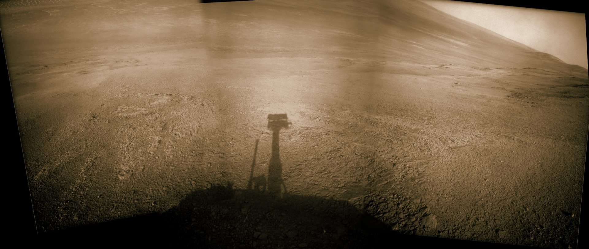
NASA’s Opportunity rover acquired this Martian panoramic view from a promontory that overlooks Perseverance Valley below – scanning from north to south. It is centered on due East and into the interior of Endeavour crater. Perseverance Valley descends from the right and terminates down near the crater floor in the center of the panorama. The far rim of Endeavour crater is seen in the distance, beyond the dark floor. Rover deck and wheel tracks at right. This navcam camera photo mosaic was assembled from raw images taken on Sol 4730 (14 May 2017) and colorized. Credit: NASA/JPL/Cornell/Ken Kremer/kenkremer.com/Marco Di Lorenzo
The valley slices downward from the crest line through the rim from west to east at a breathtaking slope of about 15 to 17 degrees – and measures about two football fields in length!
Huge Endeavour crater spans some 22 kilometers (14 miles) in diameter on the Red Planet. Perseverance Valley slices eastwards at approximately the 8 o’clock position of the circular shaped crater. It sits just north of a rim segment called “Cape Byron.”
Why go and explore the gully at Perseverance Valley?
“Opportunity will traverse to the head of the gully system [at Perseverance] and head downhill into one or more of the gullies to characterize the morphology and search for evidence of deposits,” Arvidson elaborated to Universe Today.
“Hopefully test among dry mass movements, debris flow, and fluvial processes for gully formation. The importance is that this will be the first time we will acquire ground truth on a gully system that just might be formed by fluvial processes. Will search for cross bedding, gravel beds, fining or coarsening upward sequences, etc., to test among hypotheses.”
Exploring the ancient valley is the main science destination of the current two-year extended mission (EM #10) for the teenaged robot, that officially began Oct. 1, 2016. It’s just the latest in a series of extensions going back to the end of Opportunity’s prime mission in April 2004.
Before starting the gully descent, Opportunity conducted a walkabout at the top of the Perseverance Valley in the spillway to learn more about the region before driving down.
“The walkabout is designed to look at what’s just above Perseverance Valley,” said Opportunity Deputy Principal Investigator Ray Arvidson of Washington University in St. Louis, in a statwemwent. “We see a pattern of striations running east-west outside the crest of the rim.”
“We want to determine whether these are in-place rocks or transported rocks,” Arvidson said. “One possibility is that this site was the end of a catchment where a lake was perched against the outside of the crater rim. A flood might have brought in the rocks, breached the rim and overflowed into the crater, carving the valley down the inner side of the rim. Another possibility is that the area was fractured by the impact that created Endeavour Crater, then rock dikes filled the fractures, and we’re seeing effects of wind erosion on those filled fractures.”
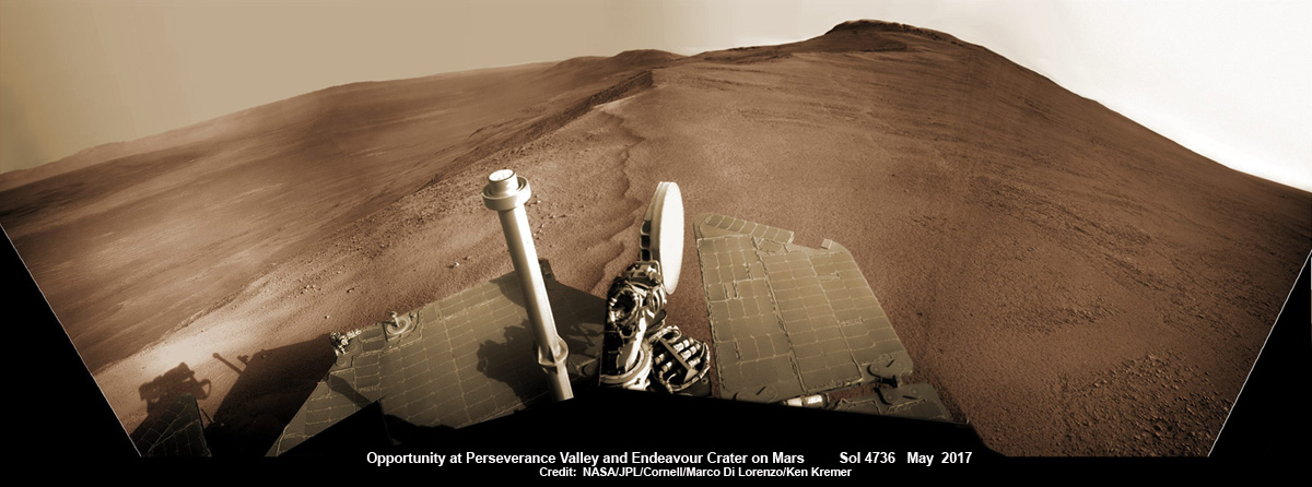
Opportunity rover looks south from the top of Perseverance Valley along the rim of Endeavour Crater on Mars in this partial self portrait including the rover deck and solar panels. Perseverance Valley descends from the right and terminates down near the crater floor. This navcam camera photo mosaic was assembled from raw images taken on Sol 4736 (20 May 2017) and colorized. Credit: NASA/JPL/Cornell/Marco Di Lorenzo/Ken Kremer/kenkremer.com
Having begun the long awaited gully descent, further movements are temporarily on hold since the start of the solar conjunction period which blocks communications between Mars and Earth for about the next two weeks, since Mars is directly behind the sun.
In the meantime, Opportunity will still collect very useful panoramic images and science data while standing still.
The solar conjunction moratorium on commanding extends from July 22 to Aug. 1, 2017.
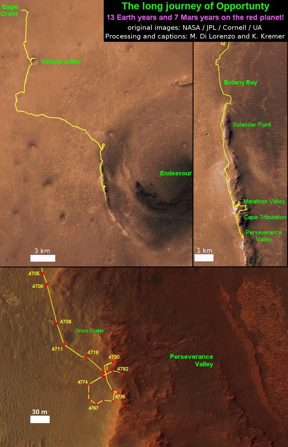
As of today, July 27, 2017, long lived Opportunity has survived over 4800 Sols (or Martian days) roving the harsh environment of the Red Planet.
Opportunity has taken over 221,625 images and traversed over 27.95 miles (44.97 kilometers.- more than a marathon.
See our updated route map below. It shows the context of the rovers over 13 year long traverse spanning more than the 26 mile distance of a Marathon runners race.
The rover surpassed the 27 mile mark milestone on November 6, 2016 (Sol 4546) and will soon surpass the 28 mile mark.
As of Sol 4793 (July 18, 2017) the power output from solar array energy production is currently 332 watt-hours with an atmospheric opacity (Tau) of 0.774 and a solar array dust factor of 0.534, before heading into another southern hemisphere Martian winter later in 2017. It will count as Opportunity’s 8th winter on Mars.
Meanwhile Opportunity’s younger sister rover Curiosity traverses up the lower sedimentary layers at the base of Mount Sharp.
And NASA continues building the next two robotic missions due to touch down in 2018 and 2020.
NASA as well is focusing its human spaceflight efforts on sending humans on a ‘Journey to Mars’ in the 2030s with the Space Launch System (SLS) mega rocket and Orion deep space crew capsule.
Stay tuned here for Ken’s continuing Earth and planetary science and human spaceflight news.
13 Year Traverse Map for NASA’s Opportunity rover from 2004 to 2017. This map shows the entire 43 kilometer (27 mi) path the rover has driven on the Red Planet during over 13 years and more than a marathon runners distance for over 4782 Sols, or Martian days, since landing inside Eagle Crater on Jan 24, 2004 – to current location at the western rim of Endeavour Crater. After studying Spirit Mound and ascending back uphill the rover has reached her next destination in May 2017- the Martian water carved gully at Perseverance Valley near Orion crater. Rover surpassed Marathon distance on Sol 3968 after reaching 11th Martian anniversary on Sol 3911. Opportunity discovered clay minerals at Esperance – indicative of a habitable zone – and searched for more at Marathon Valley. Credit: NASA/JPL/Cornell/ASU/Marco Di Lorenzo/Ken Kremer/kenkremer.com
ESA Exomars rover launch has been rescheduled to launch two years later in 2020. Credit:ESA
ESA Exomars rover launch has been rescheduled to launch two years later in 2020. Credit:ESA
Liftoff of the ExoMars 2018 rover mission currently under development jointly by Europe and Russia has just been postponed for two years to 2020, according to an announcement today, May 2, from the European Space Agency (ESA) and the Russian space agency Roscosmos.
The delay was forced by a variety of technical and funding issues that ate up the schedule margin to enable a successful outcome for what will be Europe’s first Mars rover. The goal is to search for signs of life.
“Taking into account the delays in European and Russian industrial activities and deliveries of the scientific payload, a launch in 2020 would be the best solution,” ESA explained in a statement today.
The ambitious ExoMars rover is the second of two joint Euro-Russian missions to explore the Red Planet. It is equipped with an ESA deep driller and a NASA instrument to search for preserved organic molecules.
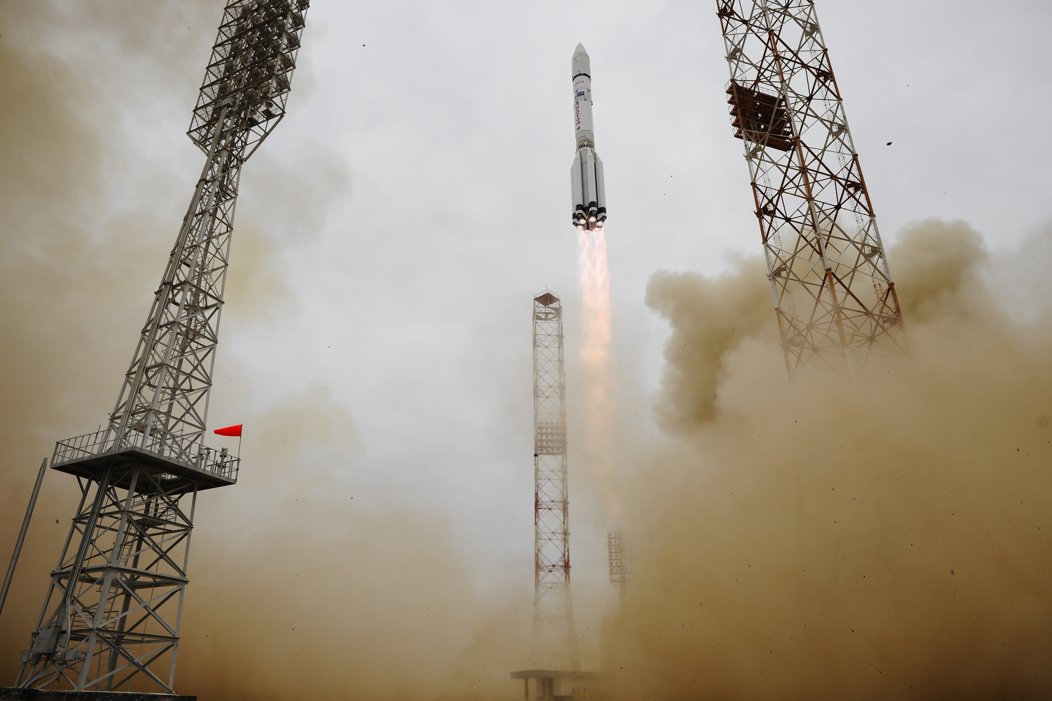
The first mission known as ExoMars 2016 was successfully launched last month from the Baikonur Cosmodrome in Kazakhstan atop a Russian Proton-M rocket on March 14.
The renamed ExoMars 2020 mission involves a European-led rover and a Russian-led surface platform and is also slated to blastoff on an Russian Proton rocket.
Roscosmos and ESA jointly decided to move the launch to the next available Mars launch window in July 2020. The costs associated with the delay are not known.
ExoMars 2016 lifted off on a Proton-M rocket from Baikonur, Kazakhstan at 09:31 GMT on 14 March 2016. Copyright ESA–Stephane Corvaja, 2016
The delay means that the Euro-Russian rover mission will launch the same year as NASA’s 2020 rover.
The rover is being built by prime contractor Airbus Defense and Space in Stevenage, England.
The descent module and surface science package are provided by Roscosmos with some contributions by ESA.
Recognizing the potential for a delay, ESA and Roscosmos set up a tiger team in late 2015 to assess the best options.
“Russian and European experts made their best efforts to meet the 2018 launch schedule for the mission, and in late 2015, a dedicated ESA-Roscosmos Tiger Team, also including Russian and European industries, initiated an analysis of all possible solutions to recover schedule delays and accommodate schedule contingencies,” said ESA in the statement.
The tiger team reported their results to ESA Director General Johann-Dietrich Woerner and Roscosmos Director General Igor Komarov.
Woerner and Komarov then “jointly decided to move the launch to the next available Mars launch window in July 2020, and tasked their project teams to develop, in cooperation with the industrial contactors, a new baseline schedule aiming towards a 2020 launch. Additional measures will also be taken to maintain close control over the activities on both sides up to launch.”
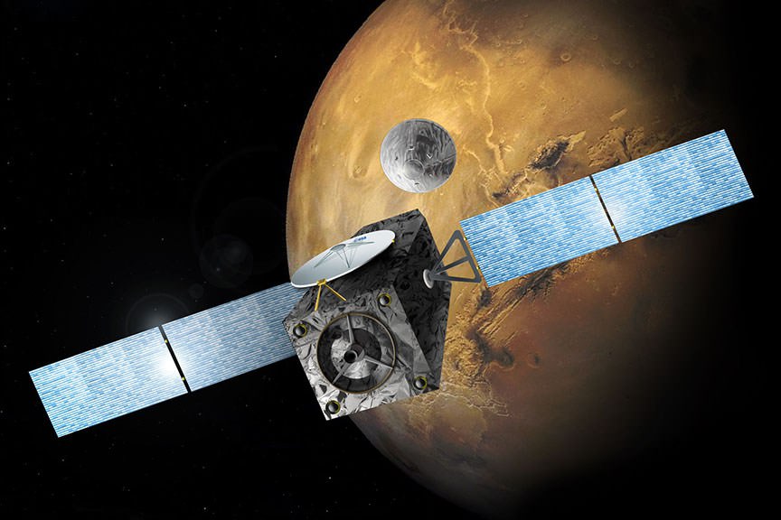
The ExoMars 2016 interplanetary mission is comprised of the Trace Gas Orbiter (TGO) and the Schiaparelli lander. The spacecraft are due to arrive at Mars in October 2016.
The ExoMars craft releases the Schiaparelli lander in October in this artist’s view. Credit: ESA
The goal of TGO is to search for possible signatures of life in the form of trace amounts of atmospheric methane on the Red Planet.
The main purpose of Schiaparelli is to demonstrate key entry, descent, and landing technologies for the follow on 2nd ExoMars mission that will land the first European rover on the Red Planet.
The now planned 2020 ExoMars mission will deliver an advanced rover to the Red Planet’s surface. It is equipped with the first ever deep driller that can collect samples to depths of 2 meters (seven feet) where the environment is shielded from the harsh conditions on the surface – namely the constant bombardment of cosmic radiation and the presence of strong oxidants like perchlorates that can destroy organic molecules.
ExoMars was originally a joint NASA/ESA project.
But thanks to hefty cuts to NASA’s budget by Washington DC politicians, NASA was forced to terminate the agencies involvement after several years of extremely detailed work and withdraw from participation as a full partner in the exciting ExoMars missions.
NASA is still providing the critical MOMA science instrument that will search for organic molecules.
Thereafter Russia agreed to take NASA’s place and provide the much needed funding and rockets for the pair of launches in March 2016 and May 2018.
TGO will also help search for safe landing sites for the ExoMars 2020 lander and serve as the all important data communication relay station sending signals and science from the rover and surface science platform back to Earth.
ExoMars 2016 is Europe’s most advanced mission to Mars and joins Europe’s still operating Mars Express Orbiter (MEX), which arrived back in 2004, as well as a fleet of NASA and Indian probes.
The Trace Gas Orbiter (TGO) and Schiaparelli lander arrive at Mars on October 19, 2016.
Stay tuned here for Ken’s continuing Earth and planetary science and human spaceflight news.
Special Guests:
Maggie Scholtz (@martianmagster), who is a Mechanical Engineer working at JPL. She worked on the Curiosity Rover, primarily on the development of the drill and sampling system.
When you’re walking around on soft ground, do you notice how your feet leave impressions? Perhaps you’ve tracked some of the looser earth in your yard into the house on occasion? If you were to pick up some of these traces – what we refer to as dirt or soil – and examine them beneath a microscope, what would you see?
Essentially, you would be seeing the components of what is known as regolith, which is a collection of particles of dust, soil, broken rock, and other materials found here on Earth. But interestingly enough, this same basic material can be found in other terrestrial environments as well – including the Moon, Mars, other planets, and even asteroids.
Definition:
The term regolith refers to any layer of material covering solid rock, which can come in the form of dust, soil or broken rock. The word is derived from the combination of two Greek words – rhegos (which means “blanket”) and lithos (which means “rock).
Earth:
On Earth, regolith takes the form of dirt, soil, sand, and other components that are formed as a result of natural weathering and biological processes. Due to a combination of erosion, alluvial deposits (i.e. moving water deposing sand), volcanic eruptions, or tectonic activity, the material is slowly ground down and laid out over solid bedrock.
Picture of Mt Magnet in the Central Yilgarn Craton in Western Australia, which dates to the Precambrian Era. Credit: geomorphologie.revues.org
It can be made up of clays, silicates, various minerals, groundwater, and organic molecules. Regolith on Earth can vary from being essentially absent to being hundreds of meters thick. Its can also be very young (in the form of ash, alluvium, or lava rock that was just deposited) to hundreds of millions of years old (regolith dating to the Precambrian age occurs in parts of Australia).
On Earth, the presence of regolith is one of the important factors for most life, since few plants can grow on or within solid rock and animals would be unable to burrow or build shelter without loose material. Regolith is also important for human beings since it has been used since the dawn of civilization (in the form of mud bricks, concrete and ceramics) to build houses, roads, and other civil works.
The difference in terminology between “soil” (aka. dirt, mud, etc.) and “sand” is the presence of organic materials. In the former, it exists in abundance, and is what separates regolith on Earth from most other terrestrial environments in our Solar System.
The Moon:
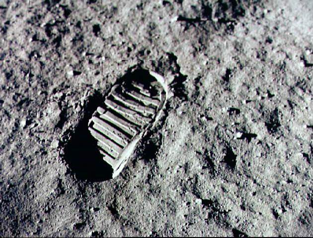
The surface of the Moon is covered with a fine powdery material that scientists refer to it as “lunar regolith”. Nearly the entire lunar surface is covered with regolith, and bedrock is only visible on the walls of very steep craters.
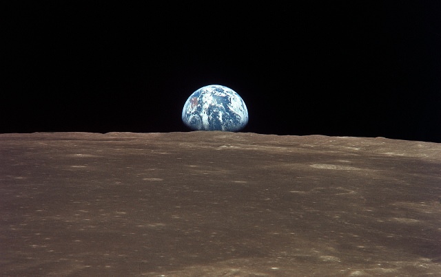
Earth viewed from the Moon by the Apollo 11 spacecraft, across a sea of lunar soil. Credit: NASA
The Moon regolith was formed over billions of years by constant meteorite impacts on the surface of the Moon. Scientists estimate that the lunar regolith extends down 4-5 meters in some places, and even as deep as 15 meters in the older highland areas.
When the plans were put together for the Apollo missions, some scientists were concerned that the lunar regolith would be too light and powdery to support the weight of the lunar lander. Instead of landing on the surface, they were worried that the lander would just sink down into it like a snowbank.
However, landings performed by robotic Surveyor spacecraft showed that the lunar soil was firm enough to support a spacecraft, and astronauts later explained that the surface of the Moon felt very firm beneath their feet. During the Apollo landings, the astronauts often found it necessary to use a hammer to drive a core sampling tool into it.
Once astronauts reached the surface, they reported that the fine moon dust stuck to their spacesuits and then dusted the inside of the lunar lander. The astronauts also claimed that it got into their eyes, making them red; and worse, even got into their lungs, giving them coughs. Lunar dust is very abrasive, and has been noted for its ability to wear down spacesuits and electronics.
Alan Bean takes a sample of lunar regolith during the Apollo 12 mission. Credit: NASA
The reason for this is because lunar regolith is sharp and jagged. This is due to the fact that the Moon has no atmosphere or flowing water on it, and hence no natural weathering process. When the micro-meteoroids slammed into the surface and created all the particles, there was no process for wearing down its sharp edges.
The term lunar soil is often used interchangeably with “lunar regolith”, but some have argued that the term “soil” is not correct because it is defined as having organic content. However, standard usage among lunar scientists tends to ignore that distinction. “Lunar dust” is also used, but mainly to refer to even finer materials than lunar soil.
As NASA is working on plans to send humans back to the Moon in the coming years, researchers are working to learn the best ways to work with the lunar regolith. Future colonists could mine minerals, water, and even oxygen out of the lunar soil, and use it to manufacture bases with as well.
Mars:
Landers and rovers that have been sent to Mars by NASA, the Russians and the ESA have returned many interesting photographs, showing a landscape that is covered with vast expanses of sand and dust, as well as rocks and boulders.
A successful scoop of Martian regolith performed by NASA’s Phoenix lander. Credit: NASA/JPL-Caltech/University of Arizona/Max Planck Institute
Compared to lunar regolith, Mars dust is very fine and enough remains suspended in the atmosphere to give the sky a reddish hue. The dust is occasionally picked up in vast planet-wide dust storms, which are quite slow due to the very low density of the atmosphere.
The reason why Martian regolith is so much finer than that found on the Moon is attributed to the flowing water and river valleys that once covered its surface. Mars researchers are currently studying whether or not martian regolith is still being shaped in the present epoch as well.
It is believed that large quantities of water and carbon dioxide ices remain frozen within the regolith, which would be of use if and when manned missions (and even colonization efforts) take place in the coming decades.
Mars moon of Deimos is also covered by a layer of regolith that is estimated to be 50 meters (160 feet) thick. Images provided by the Viking 2 orbiter confirmed its presence from a height of 30 km (19 miles) above the moon’s surface.
Asteroids and Outer Solar System:
The only other planet in our Solar System that is known to have regolith is Titan, Saturn’s largest moon. The surface is known for its extensive fields of dunes, though the precise origin of them are not known. Some scientists have suggested that they may be small fragments of water ice eroded by Titan’s liquid methane, or possibly particulate organic matter that formed in Titan’s atmosphere and rained down on the surface.
Another possibility is that a series of powerful wind reversals, which occur twice during a single Saturn year (30 Earth years), are responsible for forming these dunes, which measure several hundred meters high and stretch across hundreds of kilometers. Currently, Earth scientists are still not certain what Titan’s regolith is composed of.
Data returned by the Huygens Probe’s penetrometer indicated that the surface may be clay-like, but long-term analysis of the data has suggested that it may be composed of sand-like ice grains. The images taken by the probe upon landing on the moon’s surface show a flat plain covered in rounded pebbles, which may be made of water ice, and suggest the action of moving fluids on them.
Asteroids have been observed to have regolith on their surfaces as well. These are the result of meteoriod impacts that have taken place over the course of millions of years, pulverizing their surfaces and creating dust and tiny particles that are carried within the craters.
False color picture taken by NASA’s NEAR Shoemaker camera of Eros’ 5.3-kilometer (3.3-mile) surface crater, showing the presence of regolith inside. Credit: NASA/JPL/JHUAPL
NASA’s NEAR Shoemaker spacecraft produced evidence of regolith on the surface of the asteroid 433 Eros, which remains the best images of asteroid regolith to date. Additional evidence has been provided by JAXA’s Hayabusa mission, which returned clear images of regolith on an asteroid that was thought to be too small to hold onto it.
Images provided by the Optical, Spectroscopic, and Infrared Remote Imaging System (OSIRIS) cameras on board the Rosetta Spacecraft confirmed that the asteroid 21 Lutetia has a layer of regolith near its north pole, which was seen to flow in major landslides associated with variations in the asteriod’s albedo.
To break it down succinctly, wherever there is rock, there is likely to be regolith. Whether it is the product of wind or flowing water, or the presence of meteors impacting the surface, good old fashioned “dirt” can be found just about anywhere in our Solar System; and most likely, in the universe beyond…
We’ve done several articles about the Moon’s regolith here on Universe Today. Here’s a way astronauts might be able to extract water from lunar regolith with simple kitchen appliances, and an article about NASA’s search for a lunar digger.
Want to buy some lunar regolith simulant? Here’s a site that lets you buy it. Do you want to be a Moon miner? There’s lots of good metal in that lunar regolith.
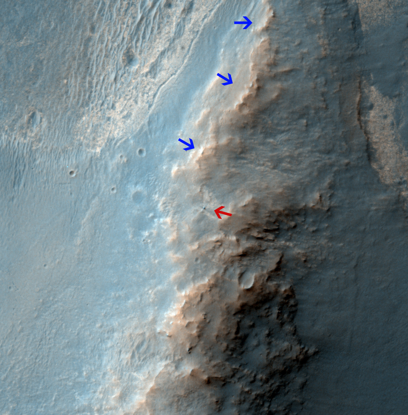
Opportunity Rover on 'Murray Ridge' Seen From Orbit on Valentine’s Day 2014 . The telescopic High Resolution Imaging Science Experiment (HiRISE) camera on NASA's Mars Reconnaissance Orbiter caught this view of NASA's Mars Exploration Rover Opportunity on Feb. 14, 2014 by the summit of Solander Point. The red arrow points to Opportunity at the center of the image. Blue arrows point to tracks left by the rover since it entered the area seen here, in October 2013. The scene covers a patch of ground about one-quarter mile (about 400 meters) wide. North is toward the top. The location is the "Murray Ridge" section of the western rim of Endeavour Crater. Credit: NASA/JPL-Caltech/Univ. of Arizona
Opportunity Rover on ‘Murray Ridge’ Seen From Orbit on Valentine’s Day 2014
The telescopic High Resolution Imaging Science Experiment (HiRISE) camera on NASA’s Mars Reconnaissance Orbiter caught this view of NASA’s Mars Exploration Rover Opportunity on Feb. 14, 2014 by the summit of Solander Point. The red arrow points to Opportunity at the center of the image. Blue arrows point to tracks left by the rover since it entered the area seen here, in October 2013. The scene covers a patch of ground about one-quarter mile (about 400 meters) wide. North is toward the top. The location is the “Murray Ridge” section of the western rim of Endeavour Crater. Credit: NASA/JPL-Caltech/Univ. of Arizona See below corresponding surface view snapped by Opportunity from this location[/caption]
NASA’s renowned Mars rover Opportunity has been spied anew in a fabulous new photo captured just days ago by NASA’s ‘Spy in the Sky’ orbiter circling overhead the Red Planet. See Opportunity from above and below – from today’s location. See orbital view above – just released today.
The highly detailed image was freshly taken on Feb. 14 (Valentine’s Day 2014) by the telescopic High Resolution Imaging Science Experiment (HiRISE) camera on NASA’s Mars Reconnaissance Orbiter (MRO) as the decade old Opportunity was investigating the tasty alien terrain on ‘Murray Ridge’ – nearby the celebrated ‘jelly doughnut’ rock by the summit of Solander Point. See surface views below.
The fabulous orbital image shows not only rover Opportunity at her location today, but also the breathtaking landscape around the robots current location as well as some of the wheel tracks created by the Martian mountaineer as she climbed from the plains below up to near the peak of Solander Point.
The scene is narrowly focused on a spot barely one-quarter mile (400 meters) wide.
Murray Ridge and Solander Point lie at the western rim of a vast crater named Endeavour that spans some 22 kilometers (14 miles) in diameter.
Here is the corresponding Martian surface view snapped by Opportunity on Feb. 16, 2014 (looking back and down to Endeavour crater), while she’s being imaged from Mars orbit on Feb. 14, 2014:
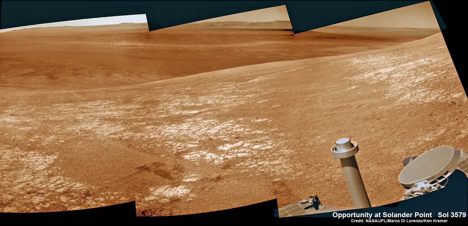
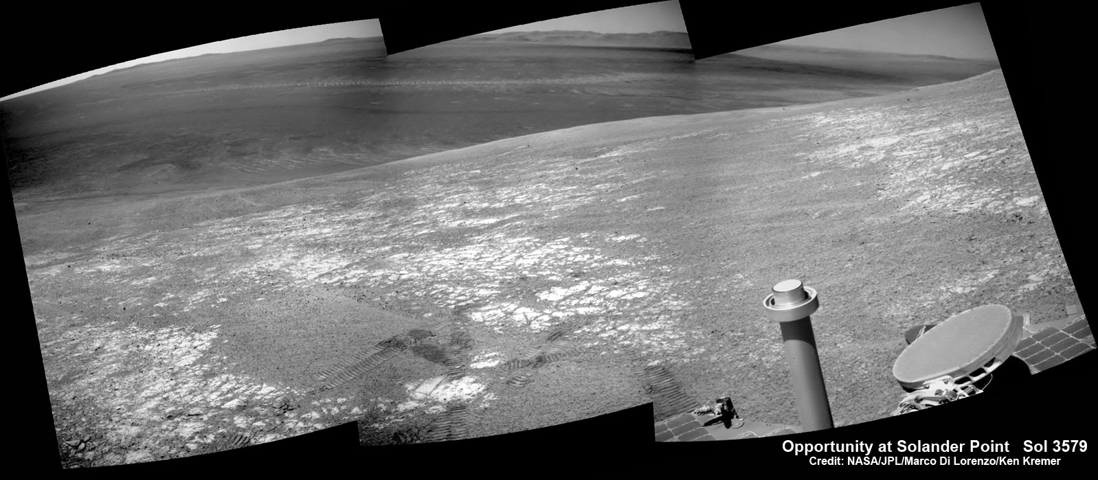
NASA’s Opportunity rover was imaged here from Mars orbit by MRO HiRISE camera on Feb. 14, 2014. This mosaic shows Opportunity’s view today while looking back to vast Endeavour crater from atop Murray Ridge by summit of Solander Point. Opportunity captured this photomosaic view on Feb. 16, 2014 (Sol 3579) from the western rim of Endeavour Crater where she is investigating outcrops of potential clay minerals formed in liquid water. Assembled from Sol 3579 colorized navcam raw images. Credit: NASA/JPL/Cornell/Marco Di Lorenzo/Ken Kremer-kenkremer.com
Endeavour is an impact scar created billions of years ago. See our 10 Year Opportunity traverse map below.
And believe it or not, that infamous ‘jelly doughnut’ rock was actually the impetus for this new imaging campaign by NASA’s MRO Martian ‘Spysat.’
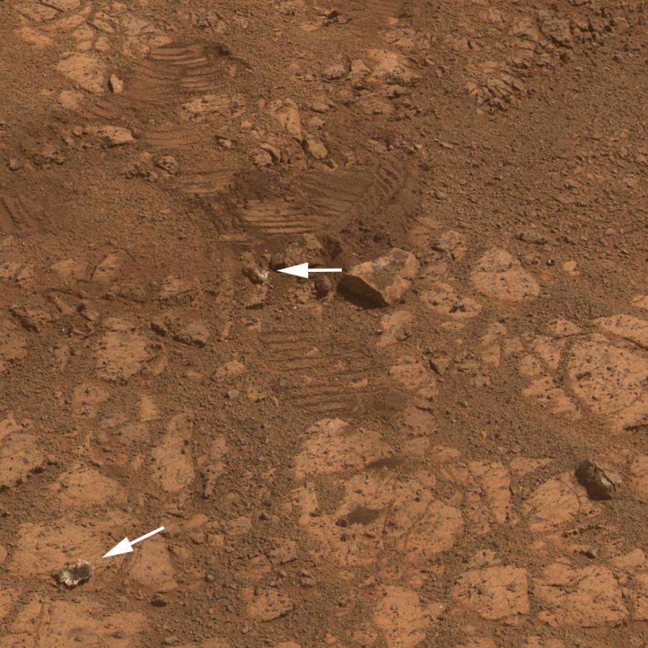
To help solve the mystery of the origin of the shiny 1.5 inches wide (4 centimeters) ‘jelly doughnut’ rock, dubbed ‘Pinnacle Island’, the science team decided to enlist the unparalleled capabilities of the HiRISE camera and imaging team in pursuit of answers.
Opportunity by Solander Point peak – 2nd Mars Decade Starts here!
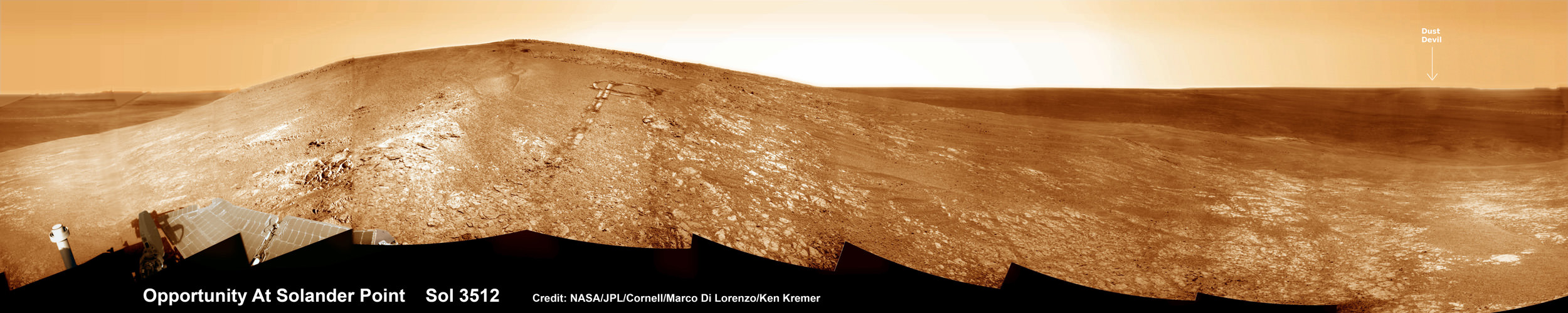
NASA’s Opportunity rover captured this panoramic mosaic on Dec. 10, 2013 (Sol 3512) near the summit of “Solander Point” on the western rim of Endeavour Crater where she starts Decade 2 on the Red Planet. She is currently investigating outcrops of potential clay minerals formed in liquid water on her 1st mountain climbing adventure. Assembled from Sol 3512 navcam raw images. Credit: NASA/JPL/Cornell/Marco Di Lorenzo/Ken Kremer-kenkremer.com
‘Pinnacle Island’ had suddenly appeared out of nowhere in a set of before/after pictures taken by Opportunity’s cameras on Jan, 8, 2014 (Sol 3540), whereas that exact same spot had been vacant of debris in photos taken barely 4 days earlier. And the rover hadn’t budged a single millimeter.
So the HiRISE research team was called in to plan a new high resolution observation of the ‘Murray Ridge’ area and gather clues about the rocky riddle.
The purpose was to “check the remote possibility that a fresh impact by an object from space might have excavated a crater near Opportunity and thrown this rock to its new location”- now known as Pinnacle Island, said NASA in a statement.
Well, no fresh crater impacting site was found in the new image.
“We see no obvious signs of a very recent crater in our image, but a careful comparison to prior images might reveal subtle changes,” wrote HiRISE principal investigator Alfred McEwen in a description today.
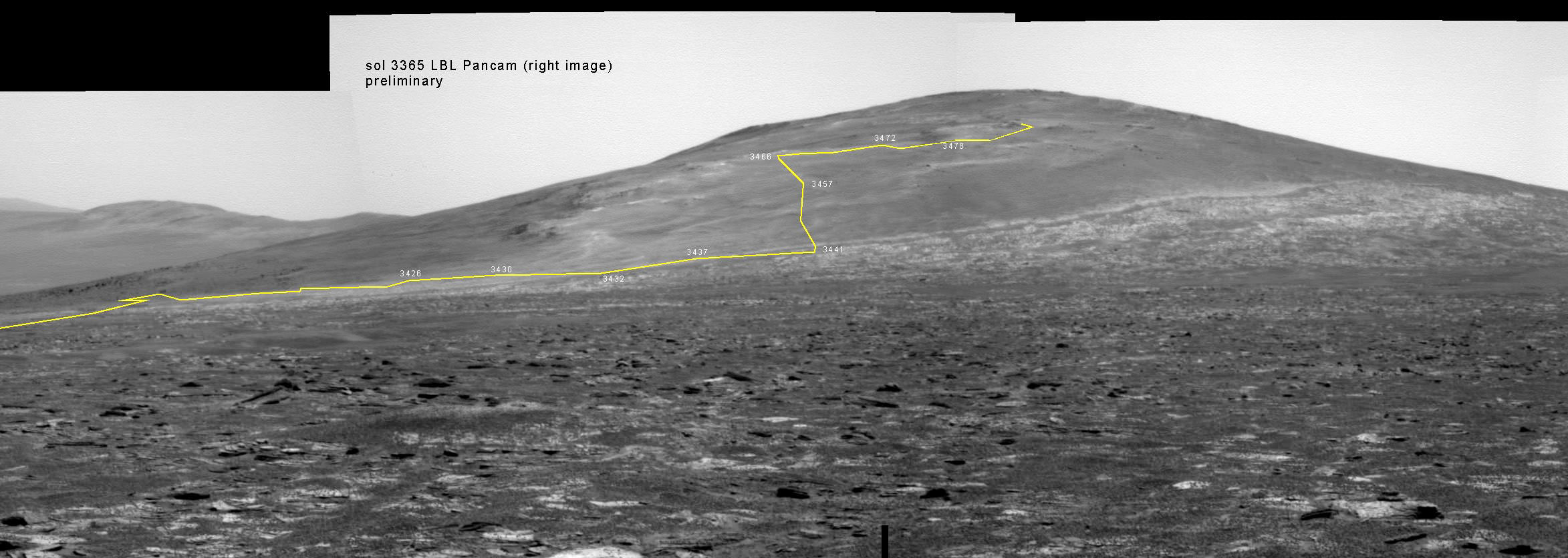
Back on sol 3365 we took this image of Solander Point as we approached it. Here I have plotted the subsequent route that Opportunity has taken in climbing up the ridge. The outcrop shown I the images below are near the end of the yellow traverse line. Caption and mosaic by Larry Crumpler/NASA/JPL/
In the meantime, as I reported here a few days ago the mystery was solved at last by the rover team after Opportunity drove a short distance away from the ‘jelly doughnut’ rock and snapped some ‘look back’ photographs to document the ‘mysterious scene’ for further scrutiny.
It turns out that the six wheeled Opportunity unknowingly ‘created’ the mystery herself when she drove over a larger rock, crushing and breaking it apart with the force from the wheels and her hefty 400 pound (185 kg) mass.
“Once we moved Opportunity a short distance, after inspecting Pinnacle Island, we could see directly uphill an overturned rock that has the same unusual appearance,” said Opportunity Deputy Principal Investigator Ray Arvidson of Washington University in St. Louis, in a NASA statement.
“Murray Ridge” and the Solander Point mountaintop are of great scientific interest because the region is riven with outcrops of minerals, including clay minerals, that likely formed in flowing liquid neutral water conducive to life – potentially a scientific goldmine.
Today, Feb 19, marks Opportunity’s 3582nd Sol or Martian Day roving Mars. She is healthy with plenty of power.
So far she has snapped over 188,800 amazing images on the first overland expedition across the Red Planet.
Her total odometry stands at over 24.07 miles (38.73 kilometers) since touchdown on Jan. 24, 2004 at Meridiani Planum.
Opportunity by Solander Point peak – 2nd Mars Decade Starts here!
NASA’s Opportunity rover captured this panoramic mosaic on Dec. 10, 2013 (Sol 3512) near the summit of “Solander Point” on the western rim of vast Endeavour Crater where she starts Decade 2 on the Red Planet. She is currently investigating summit outcrops of potential clay minerals formed in liquid water on her 1st mountain climbing adventure. See wheel tracks at center and dust devil at right. Assembled from Sol 3512 navcam raw images. Credit: NASA/JPL/Cornell/Marco Di Lorenzo/Ken Kremer-kenkremer.com
Meanwhile on the opposite side of Mars, Opportunity’s younger sister rover Curiosity is trekking towards gigantic Mount Sharp and just crested over the Dingo Gap sand dune. She celebrated 500 Sols on Mars on New Years Day 2014.
Finally, China’s Yutu rover has awoken for her 3rd workday on the Moon.
Stay tuned here for Ken’s continuing Opportunity, Curiosity, Chang’e-3, LADEE, MAVEN, Mars rover, MOM and continuing planetary and human spaceflight news.
This image from the panoramic camera (Pancam) on NASA’s rover Opportunity shows the location of a rock called “Pinnacle Island” before it appeared in front of the rover in early January 2014. Arrow at lower left. This image was taken during Sol 3567 of Opportunity’s work on Mars (Feb. 4, 2014). Credit: NASA/JPL-Caltech/Cornell Univ./Arizona State Univ.
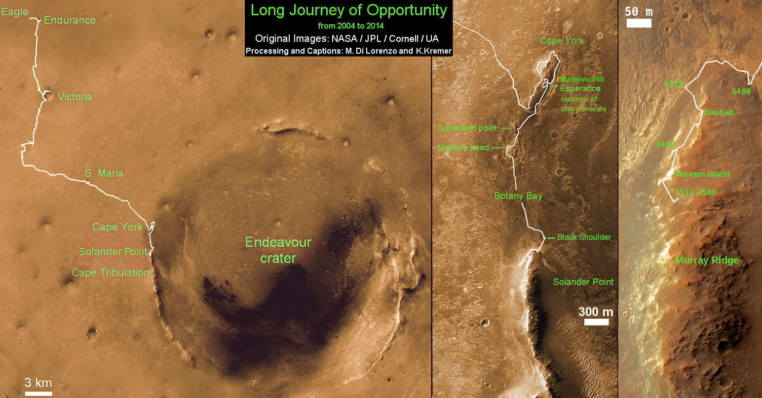
Traverse Map for NASA’s Opportunity rover from 2004 to 2014
This map shows the entire path the rover has driven during a decade on Mars and over 3560 Sols, or Martian days, since landing inside Eagle Crater on Jan 24, 2004 to current location by Solander Point summit at the western rim of Endeavour Crater. Rover will spend 6th winter here atop Solander. Opportunity discovered clay minerals at Esperance – indicative of a habitable zone. Credit: NASA/JPL/Cornell/ASU/Marco Di Lorenzo/Ken Kremer – kenkremer.com
NASA’s Opportunity rover was imaged here from Mars orbit by MRO HiRISE camera on Feb. 14, 2014. This mosaic shows Opportunity’s view today while looking back to vast Endeavour crater from atop Murray Ridge by summit of Solander Point. Opportunity captured this photomosaic view on Feb. 16, 2014 (Sol 3579) from the western rim of Endeavour Crater where she is investigating outcrops of potential clay minerals formed in liquid water. Assembled from Sol 3579 navcam raw images. Credit: NASA/JPL/Cornell/Marco Di Lorenzo/Ken Kremer-kenkremer.com
Special Guests: Stephen Pakbaz, designer of the LEGO Mars Rover Kit, and Ray Sanders from CosmoQuest, who is unboxing and building the kit as we hang out!