Perseverance’s Landing … Seen From Orbit!

The Mars 2020 descent stage holding NASA’s Perseverance rover can be seen falling through the Martian atmosphere, its parachute trailing behind, in this image taken on February 18, 2021 by the HiRISE camera on the Mars Reconnaissance Orbiter. Credit: NASA/JPL/UArizona

The HiRISE camera on the Mars Reconnaissance Orbiter has done it again.

The imaging team was able to capture the Perseverance rover as it descended through the Martian atmosphere, hanging under its parachute.

Stunning.

Continue reading “Perseverance’s Landing … Seen From Orbit!”

You Know it’s Spring on Mars When the Carbon Dioxide is Starting to Sublimate

The first signs of Spring in the northern polar ice cap on Mars: fans of dust launched by sublimating gas. Credit: NASA/JPL/UArizona

The northern hemisphere of Mars is beginning to thaw from winter. But for the red planet, that doesn’t mean that birds will sing and flowers will bloom. It means that the carbon dioxide will sublimate. It’s still beautiful though.

Continue reading “You Know it’s Spring on Mars When the Carbon Dioxide is Starting to Sublimate”

Layers Upon Layers of Rock in Candor Chasma on Mars

In many ways, Mars is the planet that is most similar to the Earth. The red world has polar ice caps, a nearly 24-hour rotation period (about 24 hours and 37 minutes), mountains, plains, dust storms, volcanoes, a population of robots, many of which are old and no longer work, and even a Grand Canyon of sorts. The ‘Grand Canyon’ on Mars is actually far grander than any Arizonan gorge. Valles Marineris dwarfs the Grand Canyon of the southwestern US, spanning 4,000 km in length (the distance between LA and New York City), and dives 7 kilometers into the Martian crust (compared to a measly 2km of depth seen in the Grand Canyon). Newly released photos from the High-Resolution Imaging Science Experiment (HiRISE) aboard the Mars Reconnaissance Orbiter (MRO) reveal a stunning look at eroding cliff faces in Candor Chasma, a gigantic canyon that comprises a portion of the Valles Marineris system.

Continue reading “Layers Upon Layers of Rock in Candor Chasma on Mars”

This Martian Lava Tube Skylight is 50 Meters Across. The Biggest Lava Tube on Earth is Only 15 Meters Across

This is the collapsed ceiling of a Martian lava tube. It measures 50 meters (150 ft) across, much larger than any Earth lava tubes. Image Credit: NASA/JPL/University of Arizona

NASA’s Mariner 9 was the first spacecraft to orbit another planet when it reached Mars in late 1971. It got there only a few weeks before the Soviet Union’s Mars 2 and Mars 3 spacecraft, despite being launched 11 days later than those missions. Unfortunately, there was a major dust storm when Mariner 9 arrived, and NASA had to wait until January before the spacecraft could get good images.

When it did get those images, they revealed a surprise: volcanoes and lava flows cover large portions of the Martian surface.

Continue reading “This Martian Lava Tube Skylight is 50 Meters Across. The Biggest Lava Tube on Earth is Only 15 Meters Across”

The Colorful Walls of an Exposed Impact Crater on Mars

A view of the interior of an impact crater on Mars shows prominent bright layer of bedrock. Credit: NASA/JPL/UArizona

Impact craters have been called the “poor geologists’ drill,” since they allow scientists to look beneath to the subsurface of a planet without actually digging down. It’s estimated that Mars has over 600,000 craters, so there’s plenty of opportunity to peer into the Red Planet’s strata – especially with the incredible HiRISE (High Resolution Imaging Science Experiment) camera on board the Mars Reconnaissance Orbiter which has been orbiting and studying Mars from above since 2006.

Continue reading “The Colorful Walls of an Exposed Impact Crater on Mars”

Machine Learning Software is Now Doing the Exhausting Task of Counting Craters On Mars

The tiny black speck in the lower left corner of this image within the red circle is a cluster of recently formed craters spotted on Mars using a new machine-learning algorithm. This image was taken by the Context Camera aboard NASA's Mars Reconnaissance Orbiter in a region called Noctis Fossae, located at latitude -3.213, longitude: 259.415. Image Credit: NASA/JPL-Caltech/MSSS

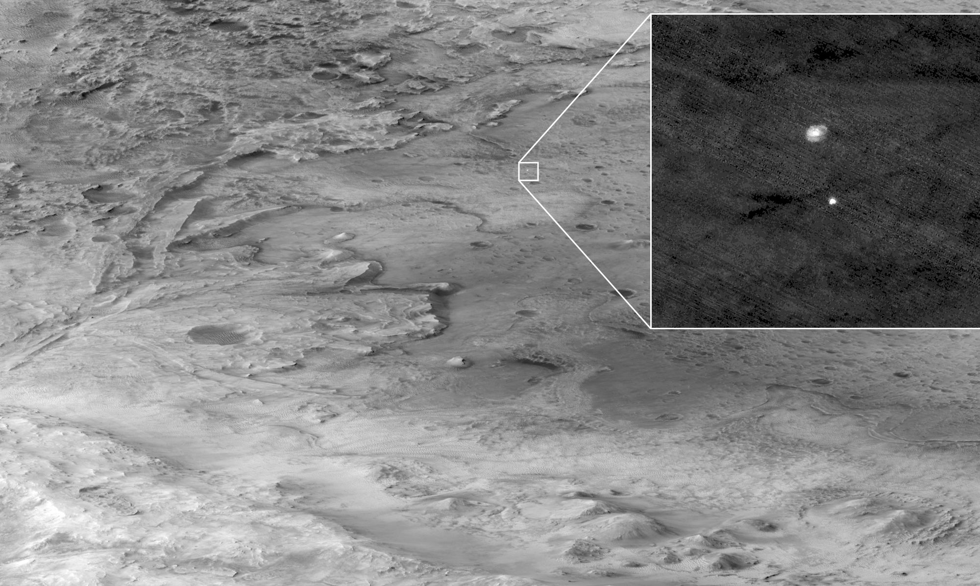
Does the life of an astronomer or planetary scientists seem exciting?

Sitting in an observatory, sipping warm cocoa, with high-tech tools at your disposal as you work diligently, surfing along on the wavefront of human knowledge, surrounded by fine, bright people. Then one day—Eureka!—all your hard work and the work of your colleagues pays off, and you deliver to humanity a critical piece of knowledge. A chunk of knowledge that settles a scientific debate, or that ties a nice bow on a burgeoning theory, bringing it all together. Conferences…tenure…Nobel Prize?

Well, maybe in your first year of university you might imagine something like that. But science is work. And as we all know, not every minute of one’s working life is super-exciting and gratifying.

Sometimes it can be dull and repetitious.

Continue reading “Machine Learning Software is Now Doing the Exhausting Task of Counting Craters On Mars”

Amazing View of How Dust Storms Grow on Mars

Two snapshots, about two weeks apart, of a 3D simulation of the 2018 Global Dust Storm performed with the NASA Ames Mars Global Climate Model. The storm began as a regional storm in Acidalia then moved eastward, triggering more dust lifting along the way (in Arabia, Sabaea, Hellas etc.). As the storm grew larger and became global, intense dust lifting events occurred in the Tharsis region, injecting dust at high altitudes. Credit: Tanguy Bertrand / Alex Kling / NASA Ames Research Center

In 2018, Mars experienced one of its global dust storms, a phenomenon seen nowhere else. As science would have it, there were no fewer than six spacecraft in orbit around Mars at the time, and two surface rovers. This was an unprecedented opportunity to watch and study the storm.

Continue reading “Amazing View of How Dust Storms Grow on Mars”

Sediments on Mars, Created By Blowing Wind or Flowing Water

The HiRISE Picture of the Day from May 9th 2020. Sedimentary rocks in and impact crater on Mars. Image Credit: NASA/JPL/UArizona

The HiRISE (High-Resolution Imaging Science Experiment) instrument on NASA’s Mars Reconnaissance Orbiter (MRO) has given us a steady stream of images of the Martian surface. It’s been in orbit around Mars since March 2006, and has greatly outlived its intended mission length.

One of the latest Hi-PODs, or HiRISE Pictures of the Day, is this one, of sedimentary rock on Mars being eroded away.

Continue reading “Sediments on Mars, Created By Blowing Wind or Flowing Water”

Dust Devils Have Left Dark Streaks All Over This Martian Crater

HiPOD from February 16th 2020 showing dust devil trails in a Martian crater. Image Credit: NASA/JPL/UArizona

There may be no life on Mars, but there’s still a lot going on there. The Martian surface is home to different geological process, which overlap and even compete with each other to shape the planet. Orbiters with powerful cameras give us an excellent view of Mars’ changing surface.

Continue reading “Dust Devils Have Left Dark Streaks All Over This Martian Crater”