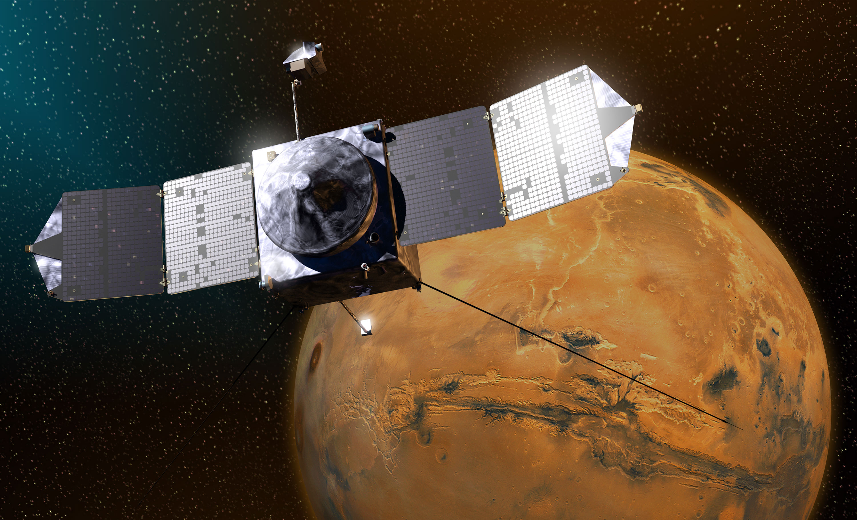
NASA’s Mars Atmosphere and Volatile EvolutioN (MAVEN) spacecraft celebrated one Earth year in orbit around Mars on Sept. 21, 2015. MAVEN was launched to Mars on Nov. 18, 2013 from Cape Canaveral Air Force Station in Florida and successfully entered Mars’ orbit on Sept. 21, 2014. Credit: NASA
Despite decades of exploration and study, Mars still has its fair share of mysteries. In particular, scientists are still trying to ascertain what happened to the water that once flowed on Mars’ surface. Unfortunately, billions of years ago, the Martian atmosphere began to be stripped away by the solar wind, which also resulted in the loss of its surface water over time – although it was not entirely clear where it went and what mechanisms were involved.
To address this, a team of scientists recently consulted data obtained by three orbiter missions studying the Martian atmosphere. In the process, they found evidence that the smaller regional dust storms that happen almost annually on Mars are making the planet drier over time. These findings suggest that storms are a major driving force behind the evolution of Mars’ atmosphere and its transition to the freezing and desiccated place we know today.
Since the 1960s and 70s, scientists have come to view Mars as something of a “dead planet.” As the first close-up images from orbit and the surface came in, previous speculation about canals, water, and a Martian civilization were dispelled. Subsequent studies also revealed that the geological activity that created features like the Tharsis Mons region (especially Olympus Mons) and Valles Marineris had ceased long ago.
However, in the past few decades, robotic missions have found ample evidence that Mars is still an active place. A recent indication was an image taken by the Mars Reconnaissance Orbiter (MRO), which showed relatively fresh landslides in a crater near Nili Fossae. This area is part of the Syrtis Major region and is located just north of the Jezero Crater (where the Perseverance rover will be landing in six weeks!)
Artist's impression of the Opportunity Rover, part of NASA's Mars Exploration Program. NASA/JPL-Caltech
Martian dust storms are a pretty common occurrence, and generally happen whenever the southern hemisphere is experiencing summer. Though they can begin quite suddenly, these storms typically stay contained to a local area and last only about a few weeks. However, on occasion, Martian dust storms can grow to become global phenomena, covering the entire planet.
One such storm began back in May, starting in the Arabia Terra region and then spreading to become a planet-wide dust storm within a matter of weeks. This storm caused the skies over the Perseverance Valley, where the Opportunity rover is stationed, to become darkened, forcing the rover into hibernation mode. And while no word has been heard from the rover, NASA recently indicated that the dust storm will dissipate in a matter of weeks.
The update was posted by NASA’s Mars Exploration Program, which oversees operations for the Opportunity and Curiosity rovers, as well as NASA’s three Mars orbiters (Mars Odyssey, MRO, and MAVEN) and the Insight lander (which will land on Mars in 109 days). According to NASA, the storm is beginning to end, though it may be weeks or months before the skies are clear enough for Opportunity to exit its hibernation mode.
This global map of Mars shows a growing dust storm as of June 6, 2018. The map was produced by the Mars Color Imager (MARCI) camera on NASA’s Mars Reconnaissance Orbiter spacecraft. The blue dot indicates the approximate location of Opportunity. Image Credit: NASA/JPL-Caltech/MSSS
As noted, dust storms occur on Mars when the southern hemisphere experiences summer, which coincides with the planet being closer to the Sun in its elliptical orbit. Due to increased temperatures, dust particles are lifted higher into the atmosphere, creating more wind. The resulting wind kicks up yet more dust, creating a feedback loop that NASA scientists are still trying to understand.
Since the southern polar region is pointed towards the Sun in the summer, carbon dioxide frozen in the polar cap evaporates. This has the effect of thickening the atmosphere and increasing the surface pressure, which enhances the process by helping suspend dust particles in the air. In some cases, the dust clouds can reach up to 60 km (40 mi) or more in elevation.
Planet-wide dust storms are a relatively rare occurrence on Mars, taking place every three to four Martian years (the equivalent of approximately 6 to 8 Earth years). Such storms have been viewed many times in the past by missions like Mariner 9 (1971), Viking I (1971) and the Mars Global Surveyor (2001). In 2007, a similar storm took place that darkened the skies over where Opportunity was stationed – which led to two weeks of minimal operations and no communications.
While smaller and less intense the storm that took place back in 2007, the current storm intensified to the point where it led to a level of atmospheric opacity that is much worse than the 2007 storm. In effect, the amount of dust in the atmosphere created a state of perpetual night over the rover’s location in Perseverance Valley, which forced the rover’s science team to suspend operations.
Simulated views of a darkening Martian sky blotting out the Sun from NASA’s Opportunity rover’s point of view, with the right side simulating Opportunity’s view in the global dust storm as of June 2018. Credit: NASA/JPL-Caltech/TAMU
This is due to the fact that Opportunity – unlike the Curiosity rover, which runs on nuclear-powered battery – relies on solar panels to keep its batteries charged. But beyond suspending operations, the prolonged dust storm also means that the rover might not be to keep its energy-intensive survival heaters running – which protect its batteries from the extreme cold of Mars’ atmosphere.
Luckily, NASA scientists who have been observing the global event indicated that, as of last Monday (July 23rd), more dust was falling out of the planet’s thin air than was being raised into it. This means that the global weather event has reached its decay phase, where dust-raising events either become confined to smaller areas or stop altogether.
Using its Mars Color Imager (MARCI) and Mars Climate Sounder (MCS), NASA’s Mars Reconnaissance Orbiter (MRO) also noted surface features were beginning to reappear and that temperatures in the middle atmosphere were no longer rising – which indicates less solar heating by dust. The Curiosity rover also noted a decline in dust above its position in the Gale Crater on the other side of the planet.
This is certainly good new for the Opportunity rover, though scientists expect that it will still be a few weeks or months before its solar panels can draw power again and communications can be reestablished. The last time communications took place with the rover was on June 10th, but if there’s one thing the Opportunity rover is known for, it’s endurance!
When the rover first landed on Mars on January 25th, 2004, its mission was only expected to last ninety Martian days (sols), which is the equivalent of about 92.5 Earth days. However, as of the writing of this article, the rover has endured for 14 years and 195 days, effectively exceeding its operational lifespan 55 times over. So if any rover can survive this enduring dust storm, its Opportunity!
In the meantime, multiple NASA missions are actively monitoring the storm in support of Opportunity and to learn more about the mechanics of Martian storms. By learning more about what causes these storms, and how smaller ones can merge to form global events, future robotic missions, crewed missions and (quite possibly) Martian colonists will be better prepared to deal with them.
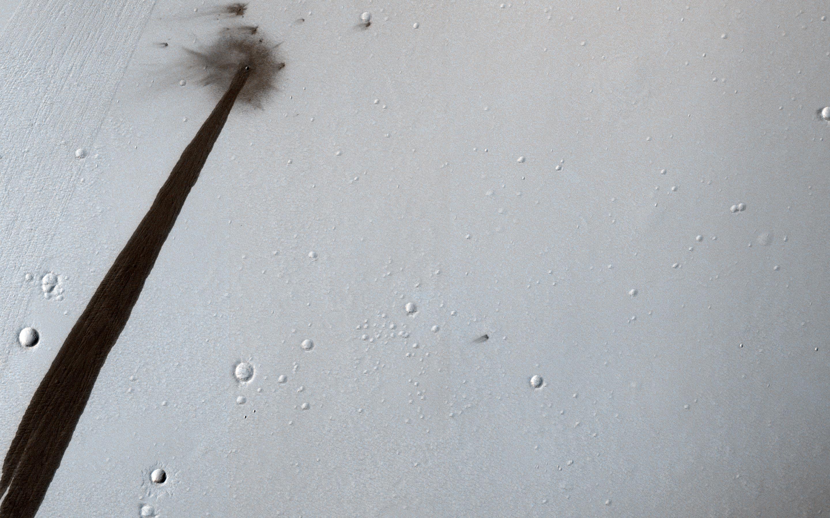
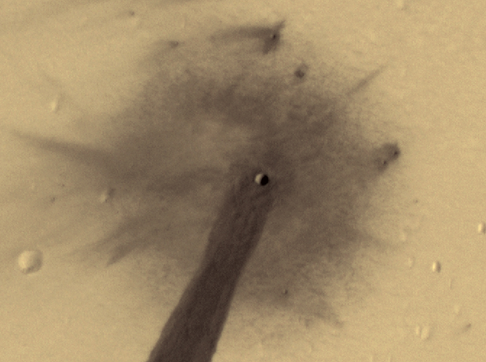
HiRISE image from NASA's Mars Reconnaissance Orbiter (MRO) showing an impact crater that triggered a slope streak. Credit: NASA/JPL/University of Arizona
In 2006, NASA’s Mars Reconnaissance Orbiter (MRO) established orbit around the Red Planet. Using an advanced suite of scientific instruments – which include cameras, spectrometers, and radar – this spacecraft has been analyzing landforms, geology, minerals and ice on Mars for years and assisting with other missions. While the mission was only meant to last two years, the orbiter has remained in operation for the past twelve.
In that time, the MRO has acted as a relay for other missions to send information back to Earth and provided a wealth of information of its own on the Red Planet. Most recently, it captured an image of an impact crater that caused a landslide, which left a long, dark streak along the crater wall. Such streaks are created when dry dust collapses down the edge of a Martian hill, leaving behind dark swaths.
Close up of the crater captured by the MRO’s HiRISE instrument. Credit: NASA/JPL/University of Arizona
In this respect, these avalanches are not unlike Recurring Slope Lineae (RSL), where seasonal dark streaks appear along slopes during warmer days on Mars. These are believed to be caused by either salt water flows or dry dust grains falling naturally. In this case, however, the dry dust on the slope was destabilized by the meteor’s impact, which exposed darker material beneath.
The impact that created the crater is believed to have happened about ten years ago. And while the crater itself (shown above) is only 5 meters (16.4 feet) across, the streak it resulted in is 1 kilometer (0.62 mi) long! The image also captured the faded scar of an old avalanche, which is visible to the side of the new dark streak.
Wider-angle view of the impact crater captured by the MRO’s HiRISE instrument and the resulting dark streak. Credit: NASA/JPL/University of Arizona
This is just the latest in a long-line of images and data packages sent back by the MRO. By providing daily reports on Mars’ weather and surface conditions, and studying potential landing sites, the MRO also paves the way for future spacecraft and surface missions. In the future, the orbiter will serve as a highly capable relay satellite for missions like NASA’s Mars 2020 rover, which will continue in the hunt for signs of past life on Mars.
At present, the MRO has enough propellant to keep functioning into the 2030s, and given its intrinsic value to the study of Mars, it is likely to remain in operation right up until it exhausts its fuel. Perhaps it will even be working when astronauts arrived on the Red Planet?
This image is a mosaic of all the images captured by the Context Camera (CTX) on NASA's Mars Reconnaissance Orbiter. The CTX has imaged over 99% of the Martian surface. Image: NASA/JPL-Caltech/MSSS
Most of us never do one thing 50,000 times in our life. So for NASA’s Mars Reconnaissance Orbiter (MRO), completing 50,000 orbits around the red planet is a big deal. And, it only took 10 years to do so.
The MRO could be called one of NASA’s flagship missions. It’s presence in orbit around Mars has helped open up our understanding of that planet immensely. And it’s done so while providing us a steady stream of eye candy.
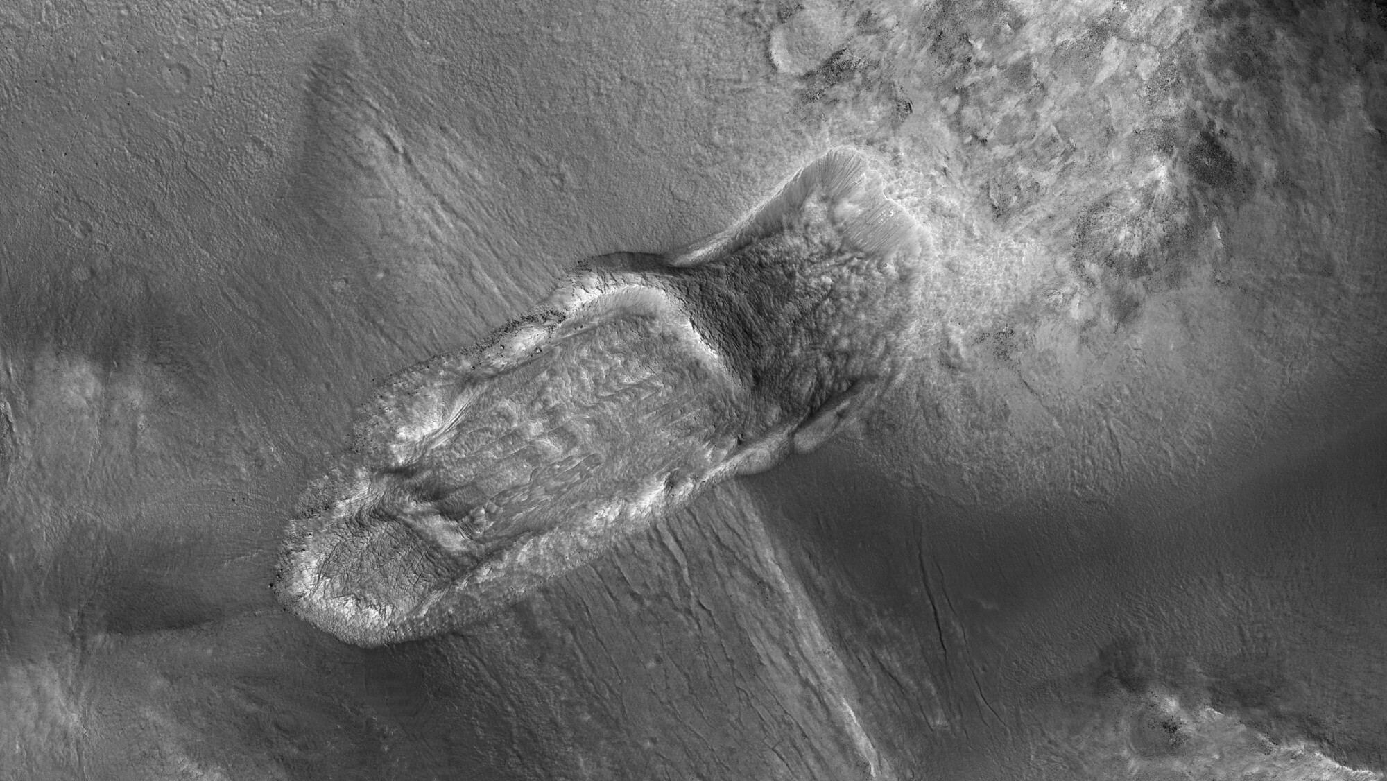
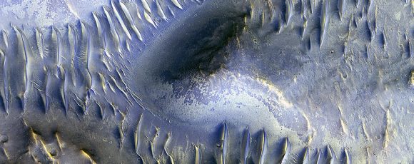
This recent image from MRO’s HiRise camera shows dune structure inside an impact crater. Image: NASA/JPL/University of Arizona
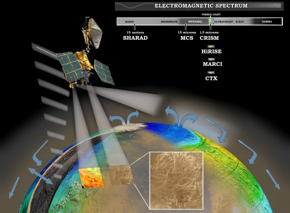
MRO was launched in 2005 and reached Mars orbit in March, 2006. After 10 years at work, it has accomplished a lot. In a recent press release, NASA calls the MRO “the most data-productive spacecraft yet.” Though most of us might know the orbiter because of it’s camera, the High-Resolution Imaging Science Experiment (HiRise), the MRO actually has a handful of other instruments that help the orbiter achieve its objectives. In broad terms, those objectives are:
to study the history of water on Mars
to look at small scale features on the surface, and identify landing sites for future Mars missions
to act as a communications relay between Mars and Earth
MRO investigating Martian water cycle – This artist’s concept represents the “Follow the Water” theme of NASA’s Mars Reconnaissance Orbiter mission. The orbiter’s science instruments monitor the present water cycle in the Mars atmosphere and the associated deposition and sublimation of water ice on the surface, while probing the subsurface to see how deep the water-ice reservoir extends. Image: By NASA/JPL/Corby Waste – http://photojournal.jpl.nasa.gov/catalog/PIA07241 (image link), Public Domain, https://commons.wikimedia.org/w/index.php?curid=374810 (Larger image here.
MRO’s HiRise camera gets all the glory, but it’s another onboard camera, the Context Camera (CTX), that is the real workhorse. The CTX is a much lower resolution than the HiRise, but its file sizes are much more manageable, an important consideration when every file has to travel from Mars to Earth—an average distance of about 225 million km.
CTX has captured 90,000 images so far in MRO’s mission, and each one captures details smaller than a tennis court. In the course of the mission so far, CTX has images that cover 99.1% of the Martian surface. Over 60% of the planet has been covered twice.
“Reaching 99.1-percent coverage has been tricky…” – Context Camera Team Leader Michael Malin
“Reaching 99.1-percent coverage has been tricky because a number of factors, including weather conditions, coordination with other instruments, downlink limitations, and orbital constraints, tend to limit where we can image and when,” said Context Camera Team Leader Michael Malin of Malin Space Science Systems, San Diego.
Malin said, “Single coverage provides a baseline we can use for comparison with future observations, as we look for changes. Re-imaging areas serves two functions: looking for changes and acquiring stereoscopic views from which we can make topographic maps.”
Because the CTX captures image of the same surface areas twice, it documents changes on the surface. There have been over 200 instances of impact craters appearing in a second image of the same area. Scientists have used this to calculate the rate that meteorites impact Mars.
The instruments on board the MRO work as a team. The CTX can capture images of areas of interest, and the HiRise can be used for higher-resolution images of the same area. By locating fresh impact craters, then studying them more closely, the MRO has helped discover the presence of what looked like sub-surface ice on Mars. A third instrument, the Compact Reconnaissance Imaging Spectrometer for Mars (CRISM), confirmed the presence of ice.
The CTX is the workhorse camera, and the HiRise is the diva, but MRO actually has a third camera: the Mars Color Imager (MARCI). MARCI is a very low resolution camera compared to the others. It’s also a wide-angle camera with really only one purpose: characterizing Martian weather. Every day, MARCI takes about 84 images which together create a daily global map of Mars. You can see a weekly Martian weather report from MARCI here.
The MRO recently manoeuvered itself into position for its next task—helping the InSight Lander. The MRO must receive critical radio transmissions from NASA’s InSight Lander as it descends to Mars. Insight will use its instruments to examine the interior of Mars for clues to how rocky planets form. Not only did MRO help find a landing spot for Insight, but it will hold the lander’s hand as it descends, and it will act as a data relay.
“After 11 and a half years in flight, the spacecraft is healthy and remains fully functional.” – MRO Project Manager Dan Johnston.
There’s no end in sight for the MRO. It just keeps going and going, and fulfilling its mission objectives on a continuing basis. “After 11 and a half years in flight, the spacecraft is healthy and remains fully functional,” said MRO Project Manager Dan Johnston at NASA’s Jet Propulsion Laboratory, Pasadena, California. “It’s a marvelous vehicle that we expect will serve the Mars Exploration Program and Mars science for many more years to come.”
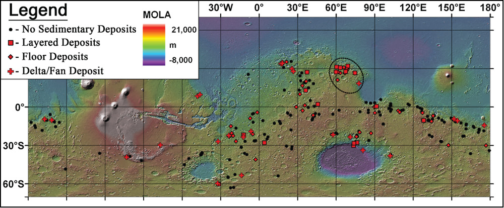
Map of 226 ancient lakes on Mars. Credit: Goudge, T.A., Head, J.W., Mustard, J.F. and Fassett, C.I./MOLA/NASA
[/caption]
Mars was once a much wetter world than it is now, with hot springs, rivers, lakes and perhaps even oceans. Just how wet exactly, and for how long, is still a subject of considerable debate. One vital clue comes from clay mineral deposits and sediments left over after the water disappeared, but still visible now. They provide a valuable insight into what Mars used to be like, and why it is the cold, dry place we see today.
A team of scientists from Brown University has just completed a new study of ancient lake beds on Mars, specifically looking at the clay deposits within them, to try to determine how many of these lakes still contain such deposits and their composition. So what do they tell us about conditions on early Mars? How does this affect the search for evidence of life?
As it turns out, about a third of the lake beds examined still show evidence for clay deposits. A total of 79 lake beds out of 226 studied to be exact, indicating that they are less common on Mars than on Earth. The reason for this may be that the chemistry of the water was not ideal for preserving clays or that the lakes were relatively short-lived.
The paper was just published in Icarus on March 2, 2012.
From the abstract:
“These results indicate that hydrated and evaporite minerals are not as commonly associated with lacustrine deposits on Mars as they are on Earth. This suggests in situ alteration and mineral precipitation, a common source of such minerals in terrestrial lakes, was not a major process occurring in these paleolacustrine systems, and that the observed minerals are likely to be present as transported material within the lacustrine deposits. The lack of widespread in situ alteration also suggests that either the water chemistry in these paleolake systems was not conducive to aqueous alteration and mineral precipitation, or that the open-basin lake systems were relatively short-lived.”
Images for the study came from the Mars Reconnaissance Orbiter, Mars Odyssey and Mars Express spacecraft.
Clay deposits have become a primary focus of study by orbiters and rovers, as they could preserve fossil traces of early life, just as they do on Earth. Even if they are less common on Mars, the fact that they do exist there is exciting, and there is now much interest in exploring them further. Apart from underground, they are the best places to look for such evidence of life. It is also possible that additional deposits have been buried underground, waiting to be discovered.
The Opportunity rover is currently very close to a treasure trove of clays in Endeavour crater, and it is expected to head straight for them after its winter “hibernation” is over in the next few months. The Curiosity rover, en route to Mars right now, will land in Gale crater next July, where there are also clay deposits near the base of a mountainous peak within the crater. Gale crater is thought to be another site of a former Martian lake.
The abstract is available here (with full paper available for purchase).
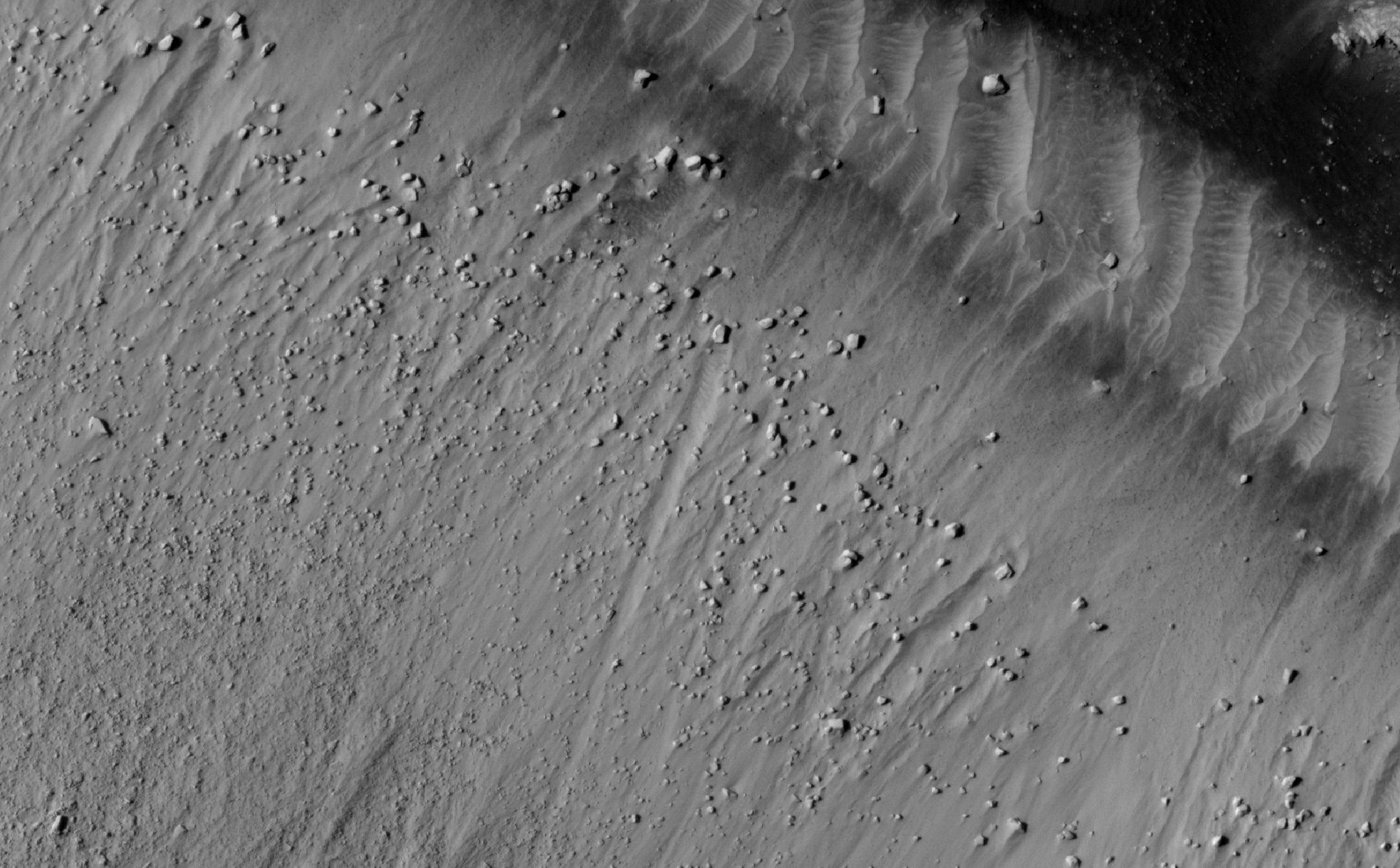
Boulders on the floor of Cerberus Fossae. Credit: NASA/JPL/University of Arizona
[/caption]
Compared to Earth, Mars is a relatively quiet planet, geologically speaking. Actually, very quiet, as in pretty much dead. While it has volcanoes much larger than any here, they have been inactive for a very long time; the latest studies suggest however that volcanic activity may have continued until only a matter of millions of years ago. That seems like an eternity to our human sense of time, but geologically, it is quite recent.
There is also the massive canyon system Valles Marineris, much larger than the Grand Canyon here on Earth, and evidence for ancient hot springs, glaciers, etc. which also show that Mars was once much more active than it is today.
Earthquakes are a common, daily occurrence on our planet, but what about Mars? If they do still happen, they would seem to be much more infrequent than they are here. The new study, however, supports the idea that Mars was geologically active for longer than previously thought, and perhaps still is.
Scientists in Europe have been examining images of a Martian fault system, Cerberus Fossae, taken by the Mars Reconnaissance Orbiter. They’ve found a spot where boulders have tumbled down cliffs near the fault; what’s interesting is that they are primarily found in one location, best explained by marsquakes rather than melting ice and avalanches. This grouping of boulders suggests that they were near the epicentre of a marsquake. The trails behind the rolling boulders are still visible, indicating that they must have fallen relatively recently, with not enough time yet for winds to erase the trails.
Closeup of boulders and trails in Cerberus Fossae. Credit: NASA/JPL/University of Arizona
Marsquakes would also be evidence for possible continued volcanism on the planet, even if only deep underground. That itself has further implications, since it is already known that there are massive ice deposits beneath the surface, even closer to the equator. Heat from any recent or current activity could create liquid water in places, which of course leads back to the question of possible present or past life.
Falling boulders, then, while an interesting observation in themselves, may actually also help to solve some of the ongoing mysteries about the Red Planet.
The study was published in the Journal of Geophysical Research. The paper is available here (by subscription or for $25.00 US).
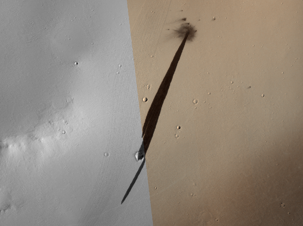
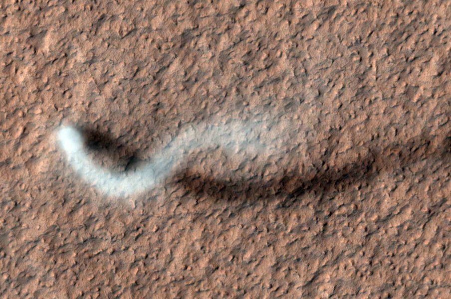
A towering dust devil, casts a serpentine shadow over the Martian surface in this image acquired by the High Resolution Imaging Science Experiment (HiRISE) camera on NASA's Mars Reconnaissance Orbiter. Image credit: NASA/JPL-Caltech/Univ. of Arizona
[/caption]
Mars orbiters, rovers and landers have all captured devils in action before. But this latest shot is a whopper (to speak in the vernacular of the peasantry…*) – not to mention incredibly awesome! The HiRISE camera (High Resolution Imaging Science Experiment) on the Mars Reconnaissance Orbiter has taken an image of an afternoon whirlwind on Mars lofting a twisting column of dust more than 800 meters (about a half a mile) high, with the dust plume about 30 meters or yards in diameter.
HiRISE captured the image on Feb. 16, 2012, in the Amazonis Planitia region of northern Mars. Evidence of many previous whirlwinds, or dust devils, are visible as streaks on the dusty surface shown in the image.
Scientists from JPL said the active dust devil and its delicate arc were produced by a westerly breeze partway up its height.
Just like on Earth, winds on Mars are powered by solar heating. However, Mars is now farthest from the Sun, and even though the exposure to the Sun’s rays is now less, even so, the dust devils are moving dust around on Mars’ surface.
Dust devils occur on Earth as well as on Mars. They are spinning columns of air, made visible by the dust they pull off the ground. Unlike a tornado, a dust devil typically forms on a clear day when the ground is heated by the sun, warming the air just above the ground. As heated air near the surface rises quickly through a small pocket of cooler air above it, the air may begin to rotate, if conditions are just right.
MRO and HiRISE continue to provide insights into the planet’s ancient environments and how processes such as wind, meteorite impacts and seasonal frosts continue to affect the Martian surface today. This mission – operating since 2006 in Mars orbit – has returned more data about Mars than all other orbital and surface missions combined.


