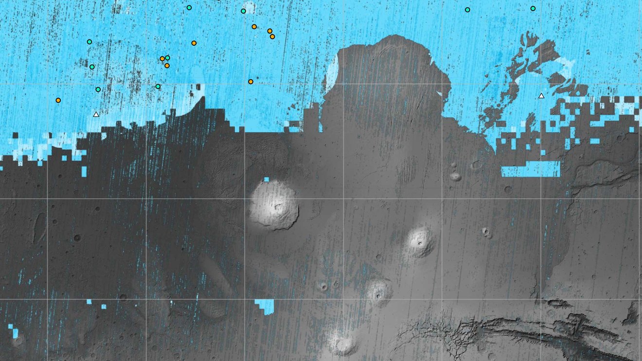
The blue areas on this map of Mars are regions where NASA missions have detected subsurface water ice (from the equator to 60 degrees north latitude). Scientists can use the map – part of the Subsurface Water Ice Mapping project – to decide where the ... Credit: NASA/JPL-Caltech/Planetary Science Institute.
Water will be one of the most important resources for human explorers on Mars. They’ll need it for drinking, propellant, breathing, and more. It makes sense to land near a spot where there’s water ice close to the surface.
NASA has released a new map of Mars’s northern hemisphere showing all the places where subsurface water ice has been detected, some of which are surprisingly close to the equator, as well as surprisingly close to the surface. This map could decide the first human landing site.
Mars has magnetized rocks in its crust that create localized, patchy magnetic fields (left). In the illustration at right, we see how those fields extend into space above the rocks. At their tops, auroras can form. Credit: NASA
The Zhurong rover has operated on the surface of Mars for over a year since it deployed on May 22nd, 2021. Before the rover suspended operations on May 20th, 2022, due to the onset of winter and the approach of seasonal sandstorms, Zhurong managed to traverse a total distance of 1.921 km (1.194 mi). During the first kilometer of this trek, the rover obtained vital data on Mars’ extremely weak magnetic fields. According to a new study by researchers from the Chinese Academy of Science (CAS), these readings indicate that the magnetic field is extremely weak beneath the rover’s landing site.
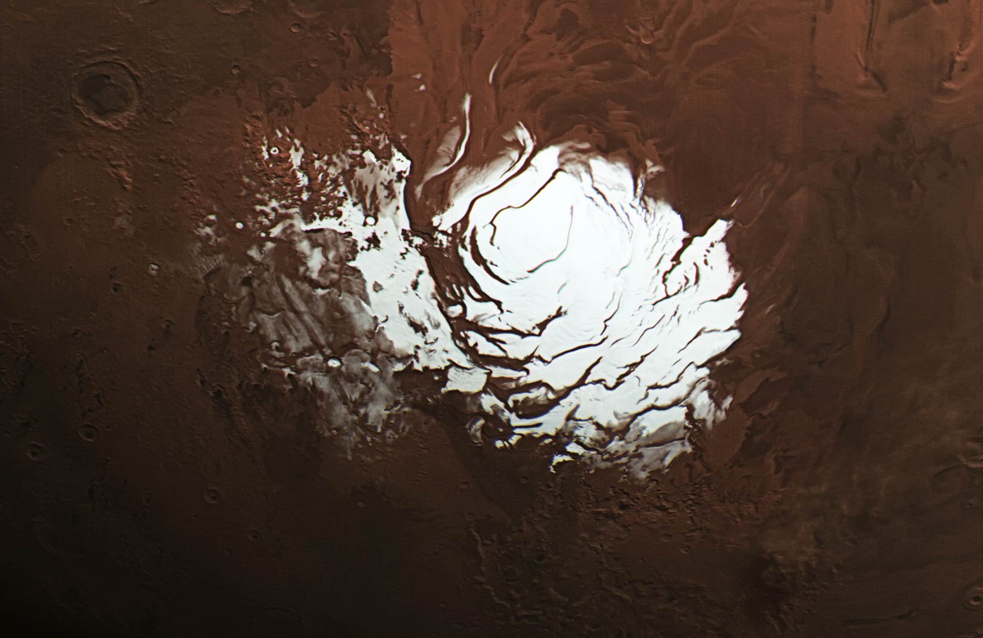
Mars’ south polar ice cap. Credit: ESA / DLR / FU Berlin /
Like Earth, Mars experiences climatic variations during the course of a year because of the obliquity of its rotational axis. This leads to the annual deposition/sublimation of the CO2 ice/snow, which results in the formation of the seasonal polar caps. Similarly, these variations in temperature result in interaction between the atmosphere and the polar ice caps, which has a seasonal effect on surface features.
On Mars, however, things work a little differently. In addition to water ice, a significant percentage of the Martian polar ice caps are made up of frozen carbon dioxide (“dry ice”). Recently, an international team of scientists used data from NASA’s Mars Global Surveyor (MGS) mission to measure how the planet’s polar ice caps grow and recede annually. Their results could provide new insights into how the Martian climate varies due to seasonal change.
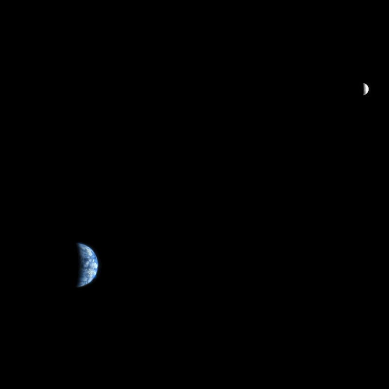
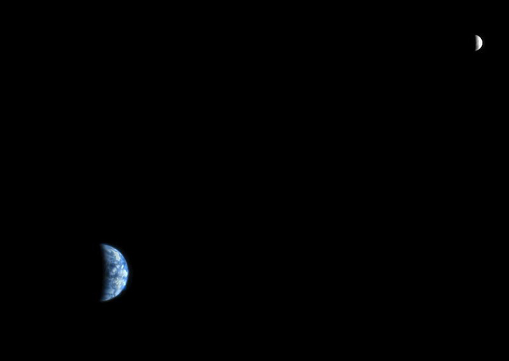
Image taken by the HiRISE camera on NASA's Mars Reconnaissance Orbiter, showing Earth and the Moon. Credit: NASA/JPL
Modern astronomy and space exploration has blessed us with a plethora of wonderful images. Whether they were images of distant planets, stars and galaxies taken by Earth-based telescopes, or close-ups of planets or moons in our own Solar System by spacecraft, there has been no shortage of inspiring pictures. But what would it look like to behold planet Earth from another celestial body?
We all remember the breathtaking photos taken by the Apollo astronauts that showed what Earth looked like from the Moon. But what about our next exploration destination, Mars? With all the robotic missions on or in orbit around the Red Planet, you’d think that there would have been a few occasions where they got a good look back at Earth. Well, as it turn out, they did!
Pictures from Space:
Pictures of Earth have been taken by both orbital missions and surface missions to Mars. The earliest orbiters, which were part of the Soviet Mars and NASA Mariner programs, began arriving in orbit around Mars by 1971. NASA’s Mariner 9 probe was the first to establish orbit around the planet’s (on Nov. 14, 1971), and was also the first spacecraft to orbit another planet.
Image of Earth and Moon, taken by the Mars Orbiter Camera of Mars Global Surveyor on May 8 2003. Credit: NASA/JPL/Malin Space Science Systems
The first orbiter to capture a picture of Earth from Mars, however, was the Mars Global Surveyor, which launched in Nov. 7th, 1996, and arrived in orbit around the planet on Sept. 12th, 1997. In the picture (shown above), which was taken in 2003, we see Earth and the Moon appearing closely together.
At the time the picture was taken, the distance between Mars and Earth was 139.19 million km (86.49 million mi; 0.9304 AU) while the distance between Mars and the Moon was 139.58 million km (86.73 million mi; 0.9330 AU). Interestingly enough, this is what an observer would see from the surface of Mars using a telescope, whereas a naked-eye observer would simply see a single point of light.
Usually, the Earth and Moon are visible as two separate points of light, but at this point in the Moon’s orbit they were too close to resolve with the naked eye from Mars. If you look closely at Earth, you can just make out the shape of South America.
Earth and the Moon, captured by the Mars Express spacecraft on July 3, 2003. Credit: ESA
The picture above was snapped by the Mars Express’s High Resolution Stereo Camera (HRSC) on the ESA’s Mars Express probe. It was also taken in 2003, and is similar in that it shows the Earth and Moon together. However, in this image, we see the two bodies at different points in their orbit – which is why the Moon looks like its farther away. Interestingly enough, this image was actually part of the first data sets to be sent by the spacecraft.
The next orbiter to capture an image of Earth from Mars was the Mars Reconnaissance Orbiter (MRO), which was launched in August of 2005 and attained Martian orbit on March 10th, 2006. When the probe reached Mars, it joined five other active spacecraft that were either in orbit or on the surface, which set a record for the most operational spacecraft in the vicinity of Mars at the same time.
In the course of its mission – which was to study Mars’ surface and weather conditions, as well as scout potential landing sites – the orbiter took many interesting pictures. The one below was taken on Oct. 3rd, 2007, which showed the Earth and the Moon in the same frame.
Image of Earth and the Moon taken by the Mars Reconnaissance Orbiter’s High Resolution Imaging Science Experiment (HiRISE) on Oct. 3rd, 2007. Credit: NASA/JPL
Pictures from the Surface:
As noted already, pictures of Earth have also been taken by robotic missions to the surface of Mars. This has been the case for as long as space agencies have been sending rovers or landers that came equipped with mobile cameras. The earliest rovers to reach the surface – Mars 2 and Mars 3– were both sent by the Soviets.
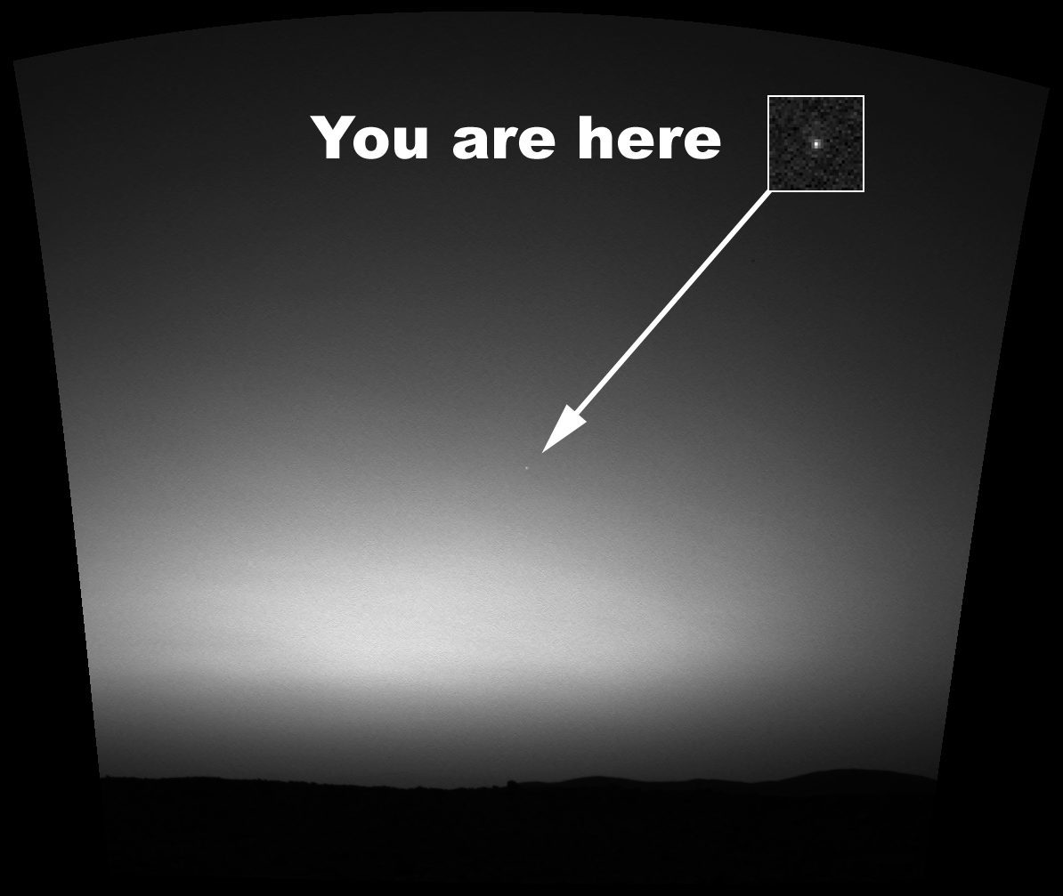
However, it was not until early March of 2004, while taking photographs of the Martian sky, that the Spirit rover became the first to snap a picture of Earth from the surface of another planet. This image was caught while the rover was attempting to observe Mars’ moon Deimos making a transit of the Sun (i.e. a partial eclipse).
This is something which happens quite often given the moon’s orbital period of about 30 hours. However, on this occasion, the rover managed to also capture a picture of distant Earth, which appeared as little more than a particularly bright star in the night sky.
Earth seen from Mars shortly before daybreak. This is the first image of the Earth from the surface of another planet. Credit: NASA/JPL
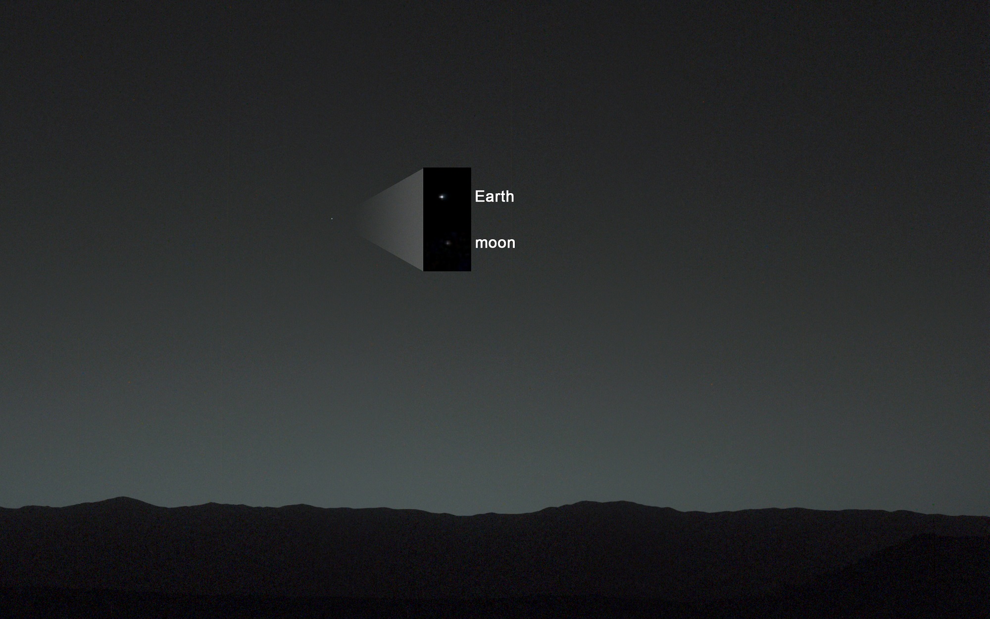
The next rover to snap an image of Earth from the Martian surface was Curiosity, which began sending back many breathtaking photos even before it landed on Aug. 6th, 2012. And on Jan. 31st, 2014 – almost a year and a half into its mission – the rover managed to capture an image of both Earth and the Moon in the night sky.
In the image (seen below), Earth and the Moon are just visible as tiny dots to the naked eye – hence the inset that shows them blown up for greater clarity. The distance between Earth and Mars when Curiosity took the photo was about 160 million km (99 million mi).
Earth has been photographed from Mars several times now over the course of the past few decades. Each picture has been a reminder of just how far we’ve come as a species. It also provides us with a preview of what future generations may see when looking out their cabin window, or up at the night sky from other planets.
Image taken by NASA’s Curiosity Mars rover, showing Earth and the Moon shining in the night sky. Credit: NASA/JPL
Phobos and Deimos, photographed here by the Mars Reconnaissance Orbiter, are tiny, irregularly-shaped moons that are probably strays from the main asteroid belt. Credit: NASA - See more at: http://astrobob.areavoices.com/2013/07/05/rovers-capture-loony-moons-and-blue-sunsets-on-mars/#sthash.eMDpTVPT.dpuf
Many of the planets in our Solar System have a system of moons. But among the rocky planets that make up the inner Solar System, having moons is a privilege enjoyed only by two planets: Earth and Mars. And for these two planets, it is a rather limited privilege compared to gas giants like Jupiter and Saturn which each have several dozen moons.
Whereas Earth has only one satellite (aka. the Moon), Mars has two small moons in orbit around it: Phobos and Deimos. And whereas the vast majority of moons in our Solar System are large enough to become round spheres similar to our own Moon, Phobos and Deimos are asteroid-sized and misshapen in appearance.
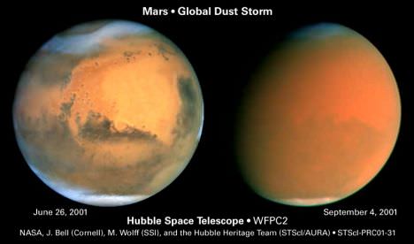
In the Journal Nature, astronomers deliver an exhaustive study of limited albeit high quality ground-based observations of Mars and come up short. A Martian mystery remains. What caused the extremely high-altitude plumes on Mars? (Credit: Nature, Sánchez-Lavega, A. et al. Feb 16, 2015, Figures 1a, 2)
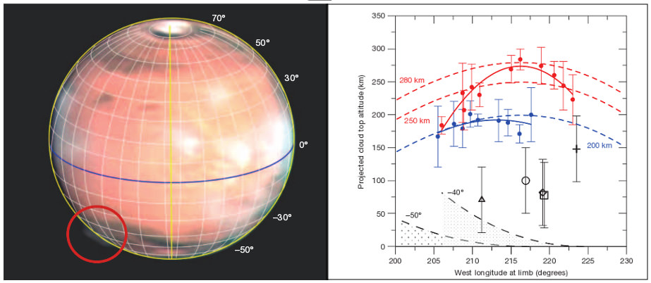
In March 2012, amateur astronomers began observing unusual clouds or plumes along the western limb of the red planet Mars. The plumes, in the southern hemisphere rose to over 200 kilometers altitude persisting for several days and then reappeared weeks later.
So a group of astronomers from Spain, the Netherlands, France, UK and USA have now reported their analysis of the phenomena. Their conclusions are inconclusive but they present two possible explanations.
Was dust lofted to extreme altitudes or ice crystals transported into space.? Hubble images show cloud formations (left) and the effects of a global dust storm on Mars (Credit: NASA/Hubbble)
Mars and mystery are synonymous. Among Martian mysteries, this one has persisted for three years. Our own planet, much more dynamic than Mars, continues to raise new questions and mysteries but Mars is a frozen desert. Frozen in time are features unchanged for billions of years.
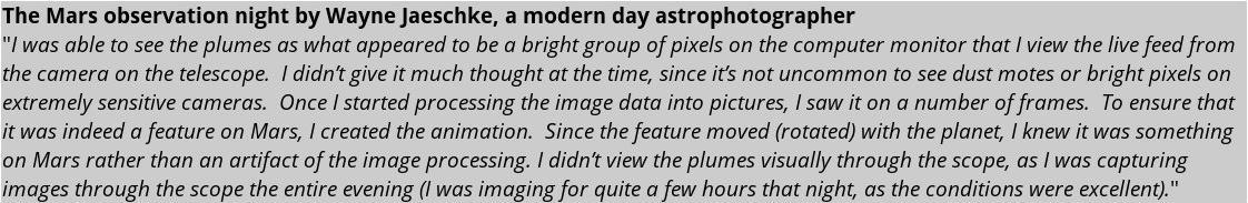
An animated sequence of images taken by Wayne Jaeschke on March 20, 2012 showing the mystery plume over the western limb of the red planet (upper right). South is up in the photo. (Credit: W. Jaeschke)
In March 2012, the news of the observations caught the attention of Universe Today contributing writer Bob King. Reported on his March 22nd 2012 AstroBob blog page, the plumes or clouds were clear to see. The amateur observer, Wayne Jaeschke used his 14 inch telescope to capture still images which he stitched together into an animation to show the dynamics of the phenomena.
Now on February 16 of this year, a team of researchers led by Agustín Sánchez-Lavega of the University of the Basque Country in Bilbao, Spain, published their analysis in the journal Nature of the numerous observations, presenting two possible explanations. Their work is entitled: “An Extremely high-altitude plume seen at Mars morning terminator.”
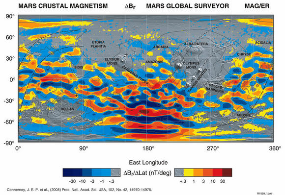
Map from the Mars Global Surveyor of the current magnetic fields on Mars. Credit: NASA/JPL
The phenomena occurred over the Terra Cimmeria region centered at 45 degree south latitude. This area includes the tiger stripe array of magnetic fields emanating from concentrations of ferrous (iron) ore deposits on Mars; discovered by the Mars Global Surveyor magnetometer during low altitude aerobraking maneuvers at the beginning of the mission in 1998. Auroral events have been observed over this area from the interaction of the Martian magnetic field with streams of energetic particles streaming from the Sun. Sánchez-Lavega states that if these plumes are auroras, they would have to be over 1000 times brighter than those observed over the Earth.
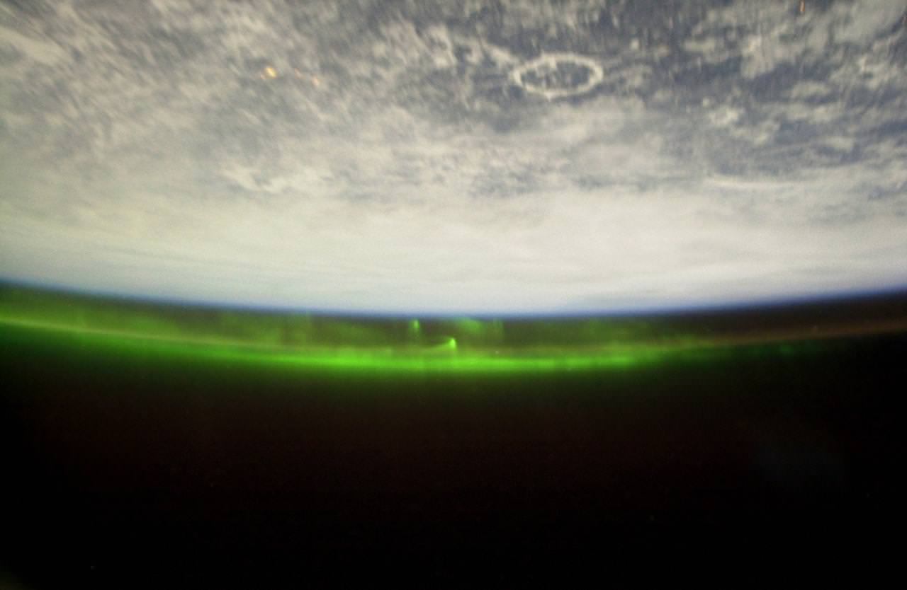
Auroras photographed from The International Space Station. The distinct Manicouagan impact crater is seen in northern Canada. Terrestial aurora exist at altitudes of 100 km (60 miles) (Credit: NASA)
The researchers also state that another problem with this scenario is the altitude. Auroras over Mars in this region have been observed up to 130 km, only half the height of the features. In the Earth’s field, aurora are confined to ionospheric altitudes – 100 km (60 miles). The Martian atmosphere at 200 km is exceedingly tenuous and the production of persistent and very bright aurora at such an altitude seems highly improbable.
The duration of the plumes – March 12th to 23rd, eleven days (after which observations of the area ended) and April 6th to 16th – is also a problem for this explanation. Auroral arcs on Earth are capable of persisting for hours. The Earth’s magnetic field functions like a capacitor storing charged particles from the Sun and some of these particles are discharged and produced the auroral oval and arcs. Over Mars, there is no equivalent capacitive storage of particles. Auroras over Mars are “WYSIWYG” – what you see is what you get – directly from the Sun. Concentrated solar high energy streams persisting for this long are unheard of.
The second explanation assessed by the astronomers is dust or ice crystals lofted to this high altitude. Again the altitude is the big issue. Martian dust storms will routinely lift dust to 60 km, still only one-third the height of the plumes. Martian dust devils will lift particles to 20 km. However, it is this second explanation involving ice crystals – Carbon Dioxide and Water – that the researchers give the most credence. In either instance, the particles must be concentrated and their reflectivity must account for the total brightness of the plumes. Ice crystals would be more easily transported to these heights, and also would be most highly reflective.
The paper also considered the shape of the plumes. The remarkable quality of modern amateur astrophotography cannot be overemphasized. Also the duration of the plumes was considered. By local noon and thereafter they were not observed. Again, the capabilities tendered by ground-based observations were unique and could not be duplicated by the present set of instruments orbiting Mars.
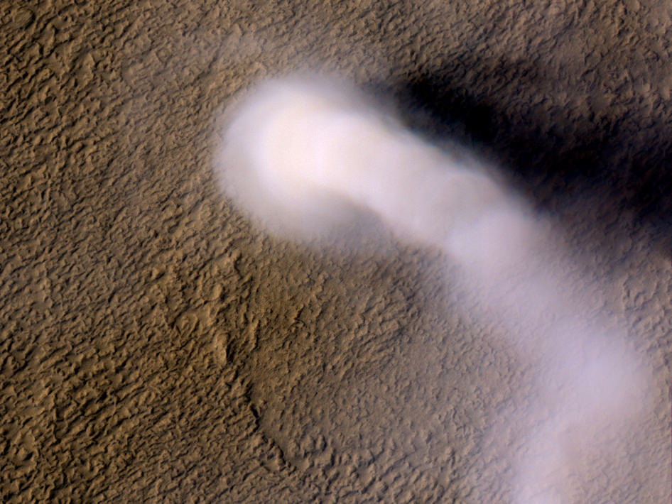
A Martian dust devil roughly 12 miles (20 kilometers) high was captured on Amazonis Planitia region of Mars, March 14, 2012 by the HiRISE camera on NASA’s Mars Reconnaissance Orbiter. The plume is little more than three-quarters of a football field wide (70 yards, or 70 meters). (Image credit: NASA/JPL-Caltech/UA)
Still too many questions remain and the researchers state that “both explanations defy our present understanding of the Mars’ upper atmosphere.” By March 20th and 21st, the researchers summarized that at least 18 amateur astronomers observed the plume using from 20 to 40 cm telescopes (8 to 16 inch diameter) at wavelengths from blue to red. At Mars, the Mars Color Imager on MRO (MARCI) could not detect the event due to the 2 hour periodic scans that are compiled to make global images.
Of the many ground observations, the researchers utilized two sets from the venerable astrophotographers Don Parker and Daiman Peach. While observations and measurements were limited, the researchers analysis was exhaustive and included modeling assuming CO2, Water and dust particles. The researchers did find a Hubble observation from 1997 that compared favorably with the 2012 events and likewise modeled that event for comparison. However, Hubble results provided a single observation and the height estimate could not be narrowly constrained.
Explanation of these events in 2012 are left open-ended by the research paper. Additional observations are clearly necessary. With increased interest from amateurs and continued quality improvements plus the addition of the Maven spacecraft suite of instruments plus India’s Mars Orbiter mission, observations will eventually be gained and a Martian mystery solved to make way for yet another.
Clouds above the rim of "Endurance Crater" in this image from NASA's Mars Exploration Rover Opportunity. These clouds occur in a region of strong vertical shear. The cloud particles (ice in this martian case) fall out, and get dragged along away from the location where they originally condensed, forming characteristic streamers. Opportunity took this picture with its navigation camera during the rover's 269th martian day (Oct. 26, 2004). Image Credit: NASA/JPL
Predicting the weather here on Earth is never an easy thing, but predicting it on Mars may be ever trickier. Such is the argument presented by a recent study concerning “macroweather” patterns on the Red Planet, a new regime for understanding how planetary environments work.
When it comes to describing the climate of a planet, two important concepts come into play. First, there’s weather, which covers day-to-day changes due to fluctuations in the atmosphere. Second, there’s climate, which is more stable and subject to change over the course of decades. Macroweather, the latest addition to the game, describes the relatively stable periods that exist between short-term weather and long-term climate.
For those of us dwelling here on planet Earth, these are familiar concepts. But researchers say this same three-part pattern applies to atmospheric conditions on Mars. The results of a new paper, published today in Geophysical Research Letters also show that the Sun plays a major role in determining macroweather.
Several dust devils cross a plain in this animation of a series of images acquired by NASA’s Mars Rover Spirit in May, 2005. (NASA/JPL-Caltech/Cornell/USGS)
The scientists chose to study Mars because of the wealth of data it has provided in recent decades, which they then used to test their theory that a transitional “macroweather” regime exists on a planet other than Earth. They used information collected from the Viking Mars lander mission from the 1970s and 1980s, and more recent data from the Mars Global Surveyor.
By taking into account how the sun heats Mars, as well as the thickness of the planet’s atmosphere, the scientists predicted that temperatures and wind would fluctuate on Mars similar to how they fluctuate on Earth. However, this transition from weather to macroweather would take place over 1.8 Martian days (about two Earth days), compared with a week to 10 days here on Earth.
“Our analysis of the data from Mars confirmed this prediction quite accurately,” said Shaun Lovejoy, a physics professor at McGill University in Montreal, Canada, and lead author of the paper. “This adds to evidence, from studies of Earth’s atmosphere and oceans, that the sun plays a central role in shaping the transition from short-term weather fluctuations to macroweather.”
Early Spring Dust Storms at the North Pole of Mars, taken by the Mars Global Surveyor spacecraft in 2002. Image Credit: NASA/JPL/Malin Space Science Systems
The findings also indicate that weather on Mars can be predicted with some skill only two days in advance, compared to 10 days on Earth.
“We’re going to have a very hard time predicting the weather on Mars beyond two days given what we have found in weather records there,” said co-author Jan-Peter Muller from the University College London Mullard Space Science Laboratory in the UK, “which could prove tricky for the European lander and rover.”
This research promises to advance scientists’ understanding of the dynamics of Earth’s own atmosphere, and could potentially provide insights into the weather of Venus, Saturn’s moon Titan, and possibly the gas giants Jupiter, Saturn, Uranus, and Neptune.
As always, in learning about other planets and their climates, scientists are finding that the planets of our Solar System may have more in common with Earth than previously thought. Because of this, studying these other worlds will inevitably help us to better understand our own.
While we’re unsure about the status of chocolates and flowers in locations far beyond Earth, there certainly is no lack of hearts for us to look at to enjoy Valentine’s Day. If you look at enough geologic features or gas clouds, statistically some of them will take on shapes that we recognize (such as faces).
Below, we’ve collected some hearts on Mars and other places in the universe. Have we missed any? Share other astronomy hearts in the comments!
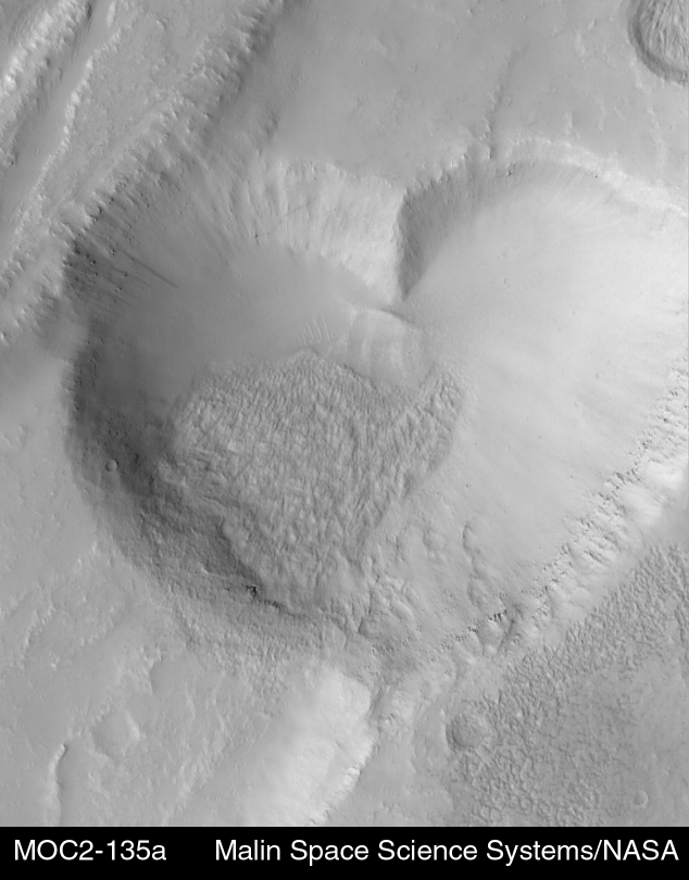
This heart-shaped feature on Mars “is actually a pit formed by collapse within a straight-walled trough known in geological terms as a graben,” wrote Malin Space Systems in 1999. Picture taken by Mars Global Surveyor. Credit: Malin Space Science Systems, MGS, JPL, NASA
A heart-shaped mesa captured by Mars Global Surveyor in 1999, in the Promethei Rupes region. Credit: Malin Space Science Systems, MGS, JPL, NASA
The Heart and Soul nebulae in an infrared mosaic from NASA’s Wide-field Infrared Survey Explorer (WISE). It is located about about 6,000 light-years from Earth. Credit: NASA/JPL-Caltech/UCLA
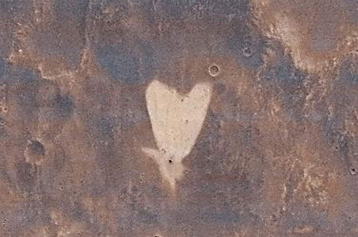
A heart-shaped feature in the Arabia Terra region of Mars is show on the left, with additional context on the right, in excerpts of an image taken by the Context Camera on NASA's Mars Reconnaissance Orbiter. Image Credit: NASA/JPL-Caltech/MSSS
[/caption]
Happy Valentine’s Day from Mars to all the readers of Universe Today !
Well it’s truly a solar system wide Valentines celebration. From the Moon, Mars and even Comet Temple 1 with some pixie Stardust for the romantic rendezvous upcoming in a few short hours [Stardust-NExT Flyby at 11:37 p.m. EST Feb 14].
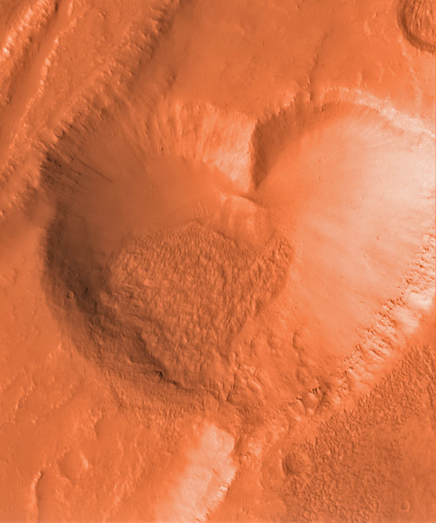
The Martian camera team from Malin Space Systems, San Diego, wishes to share a special heart-shaped feature from Arabia Terra – images above and below – with all Mars fans on this St. Valentine’s Day, Feb. 14, 2011. And certainly, I love Mars ! Especially those gorgeous and brainy twin gals Spirit & Opportunity.
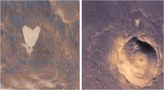
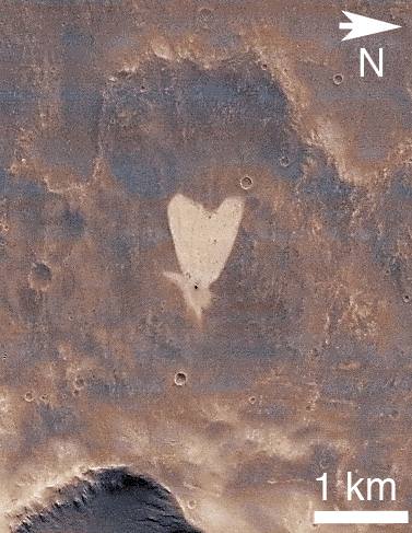
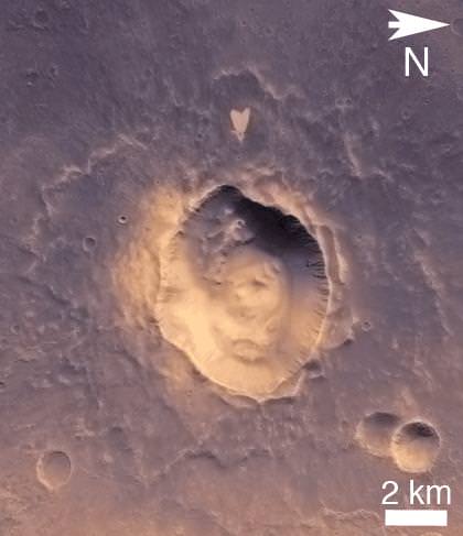
Heart-shaped feature in Arabia Terra on Mars at 21.9 degrees north latitude, 12.7 degrees west longitude. Credit: NASA/JPL-Caltech/MSSS.The image was taken on May 23, 2010 – at the start of northern summer on Mars – by the Malin-built and operated Context Camera on NASA’s Mars Reconnaissance Orbiter.
The bright heart shaped feature is about 1 kilometer (0.6 mile) long. Arabia Terra lies in the northern hemisphere of Mars
The tip of the heart lies above a small impact crater centered at 21.9 degrees north latitude, 12.7 degrees west longitude.
According to a JPL press release, “The crater is responsible for the formation of the bright, heart-shaped feature. When the impact occurred, darker material on the surface was blown away, and brighter material beneath it was revealed.
PIA13799: Heart-Shaped Feature in Arabia Terra (Wide View). Credit: NASA/JPL-Caltech/MSSS.Some of this brighter material appears to have flowed further downslope to form the heart shape, as the small impact occurred on the blanket of material ejected from a much larger impact crater.
The Jet Propulsion Laboratory, Pasadena, Calif manages MRO for NASA.
More Martian hearts images below from another Malin built camera aboard NASA’s Mars Global Surveyor orbiter
Happy Valentines Day from Mars Global Surveyor (MGS)
This heart shaped pit on Mars is located on the east flank of the Alba Patera volcano in northern Tharsis. The pit was formed by collapse within a straight-walled trough known in geological terms as a graben. Graben are formed along fault lines by expansion of the bedrock terrain. Credit: NASA/JPL-Caltech/MSSS.
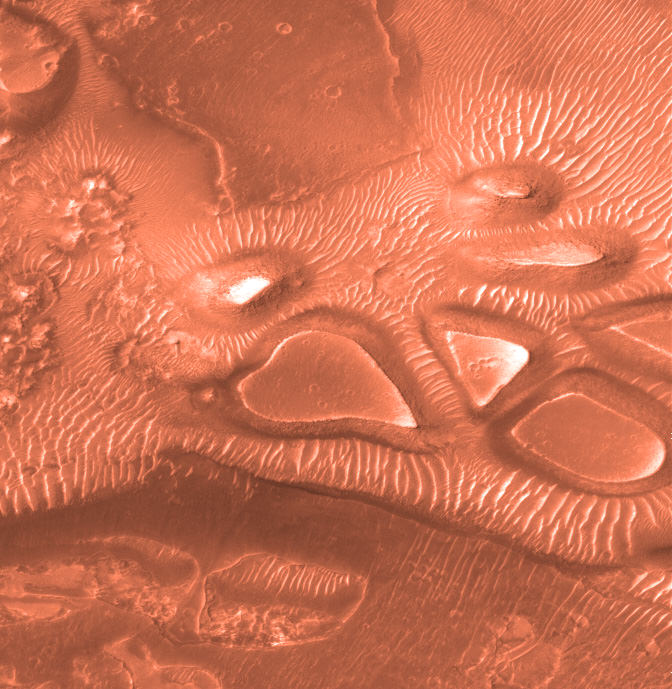
10 Martian Hearts for Valentine’s Day.
Mesas and depressions from all across Mars. Images taken by Mars Global Surveyor from 2001 to 2004. Credit: NASA/JPL-Caltech/MSSS.
Heart shaped landforms on Mars – or perhaps a box of chocolates !
Image taken by Mars Global Surveyor. Credit: NASA/JPL-Caltech/MSSS
Gullies on a Martian sand dune in this trio of images from NASA's Mars Reconnaissance Orbiter deceptively resemble features on Earth that are carved by streams of water. However, these gullies likely owe their existence to entirely different geological processes apparently related to the winter buildup of carbon-dioxide frost. Image Credit: NASA/JPL-Caltech/University of Arizona
[/caption]
Intriguing images of brand new, fresh gullies on Mars has most of us thinking of one thing: water. But at least for one type of Mars gully, carbon dioxide frost is the impetus behind fresh flows showing up on images from orbiting spacecraft.
“Gullies that look like this on Earth are caused by flowing water, but Mars is a different planet with its own mysteries,” said Serina Diniega, author of a new paper published in the journal Geology. “The timing we see points to carbon dioxide, and if the mechanism is linked to carbon-dioxide frost at these dune gullies, the same could be true for other gullies on Mars.”
Scientists have seen evidence of fresh gullies on Mars, beginning 2000 with images from the Mars Global Surveyor. Different mechanisms were proposed including water and carbon dioxide, as well as other forces.
On the HiRISE website, searching for “gullies” provides a bounty of images. Some fresh gullies are on sand dunes, commonly starting at a crest. Others are on rockier slopes, such as the inner walls of craters, sometimes starting partway down the slope.
Active Dune Gullies in Kaiser Crater (ESP_018186_1330) Active Dune Gullies in Kaiser Crater. Credit: NASA/JPL/University of Arizona
While a graduate student at the University of Arizona, Tucson, Diniega tracked changes in gullies on faces of sand dunes in seven locations on southern Mars. In looking at before-and-after images, in all cases, the gullies appeared after the known winter build-up of carbon-dioxide frost on the dunes. Before-and-after images that looked at periods in spring, summer and autumn showed no new activity.
Because new flows in these gullies apparently occured in winter, rather than at a time when any frozen water might be most likely to melt, Diniega and co-authors at the University of Arizona and Johns Hopkins University Applied Physics Laboratory believe they found evidence that carbon dioxide, rather than water, were responsible for the flows. Some carbon dioxide from the Martian atmosphere freezes on the ground during winter and sublimates back to gaseous form as spring approaches.
A series of images from HiRISE taken from 2008 to 2010 showing changes in a gully. Credit: NASA/JPL/University of Arizona
“One possibility is that a pile of carbon-dioxide frost accumulating on a dune gets thick enough to avalanche down and drag other material with it,” Diniega said. Other suggested mechanisms are that gas from sublimating frost could lubricate a flow of dry sand or erupt in puffs energetic enough to trigger slides.
The team focused their study on dune gullies that are shaped like rockier slope gullies, with an alcove at the top, a channel or multiple channels in the middle, and an apron at the bottom. The 18 dune gullies in which the researchers observed new activity range in size from about 50 meters or yards long to more than 3 kilometers (2 miles) long.


 Active Dune Gullies in Kaiser Crater. Credit: NASA/JPL/University of Arizona")
