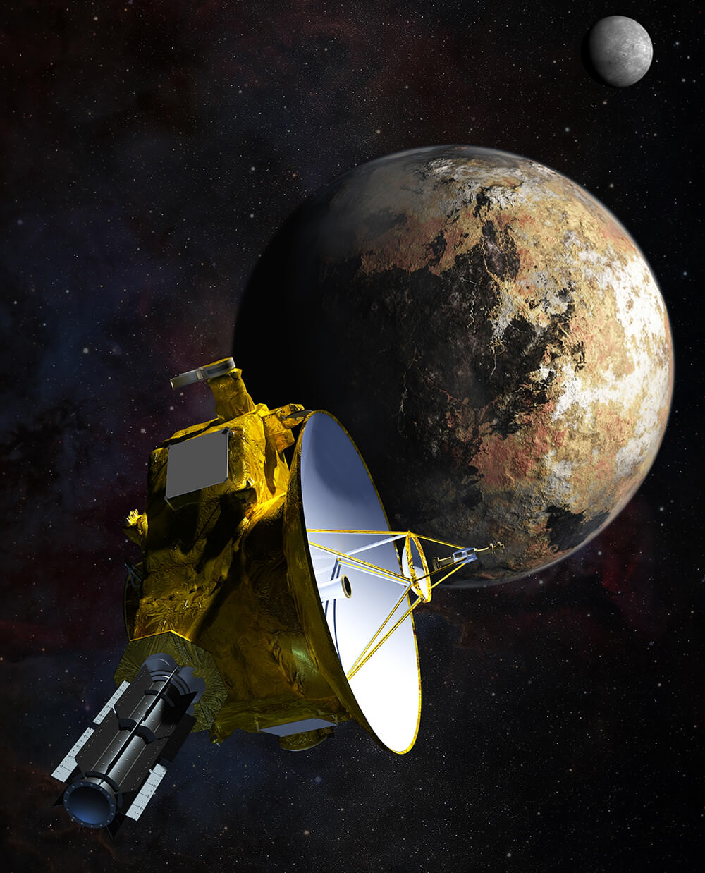
Artist's impression of New Horizons' close encounter with the Pluto–Charon system. Credit: NASA/JHU APL/SwRI/Steve Gribben
In July of 2015, NASA’s New Horizons probe made history when it became the first mission ever to conduct a close flyby of Pluto. This was followed by the spacecraft making the first-ever encounter with a Kuiper Belt Object (KBO) – known as Arrokoth (aka. 2014 MU69) – on Dec.31st, 2018. In addition, its unique position in the outer Solar System has allowed astronomers to conduct rare and lucrative science operations.
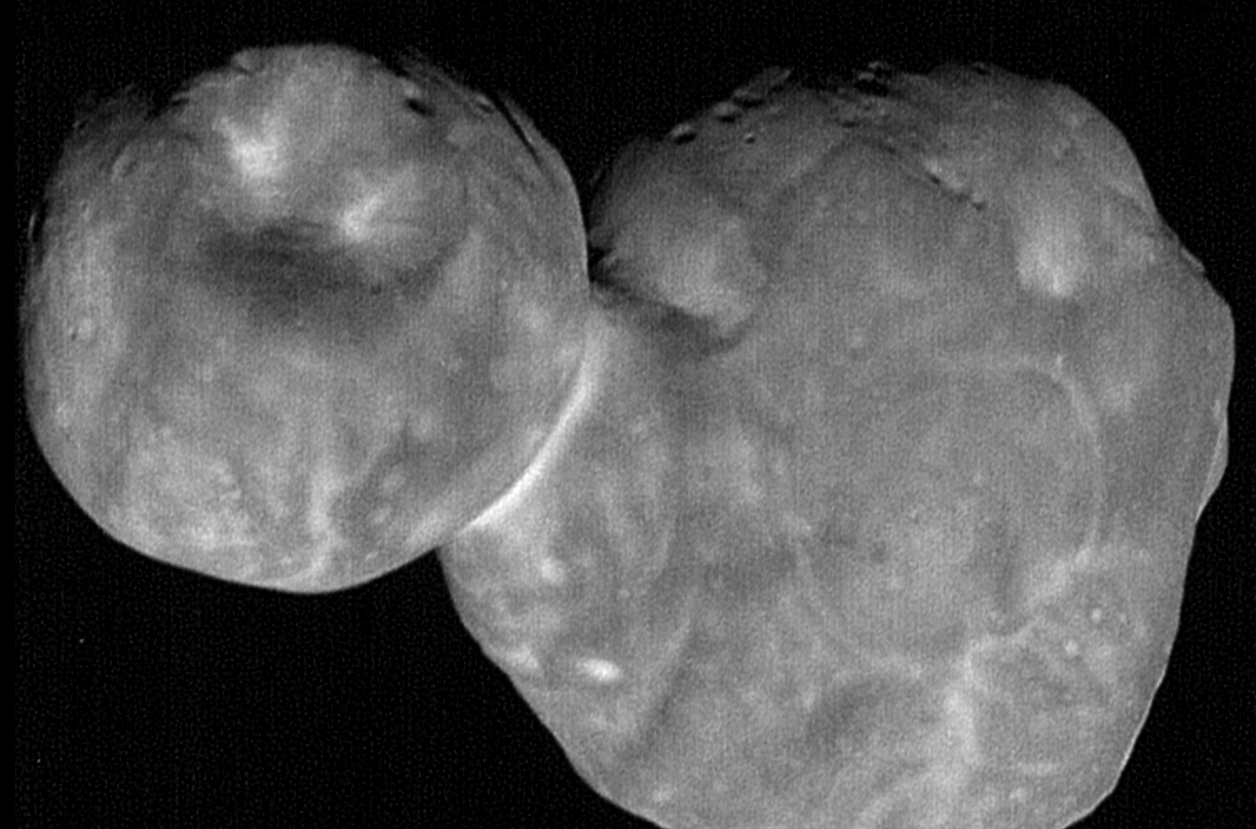
The most detailed image of Ultima Thule yet. Credits: NASA/Johns Hopkins Applied Physics Laboratory/Southwest Research Institute, National Optical Astronomy Observatory
On December 31st, 2018, the New Horizons probe conducted the first flyby in history of a Kuiper Belt Object (KBO). Roughly half an hour later, the mission controllers were treated to the first clear images of Ultima Thule (aka. 2014 MU69). Over the course of the next two months, the first high-resolution images of the object were released, as well as some rather interesting findings regarding the KBOs shape.
Just recently, NASA released more new images of Ultima Thule, and they are the clearest and most detailed to date! The images were taken as part of what the mission team described as a “stretch goal”, an ambitious objective to take pictures of Ultima Thule mere minutes before the spacecraft made its closest approach. And as you can no doubt tell from the pictures NASA provided, mission accomplished!
Artist's impression of New Horizons' close encounter with the Pluto–Charon system. Credit: NASA/JHU APL/SwRI/Steve Gribben
The New Horizons probe made history in July of 2015, being the first mission to ever conduct a close flyby of Pluto. In so doing, the mission revealed some never-before-seen things about this distant world. This included information about its many surface features, its atmosphere, magnetic environment, and its system of moons. It also provided images that allowed for the first detailed maps of the planet.
Having completed its rendezvous with Pluto, the probe has since been making its way towards its first encounter with a Kuiper Belt Object (KBO) – known as 2014 MU69. And in the meantime, it has been given a special task to keep it busy. Using archival data from the probe’s Long Range Reconnaissance Imager (LORRI), a team of scientists is taking advantage of New Horizon‘s position to conduct measurements of the Cosmic Optical Background (COB).
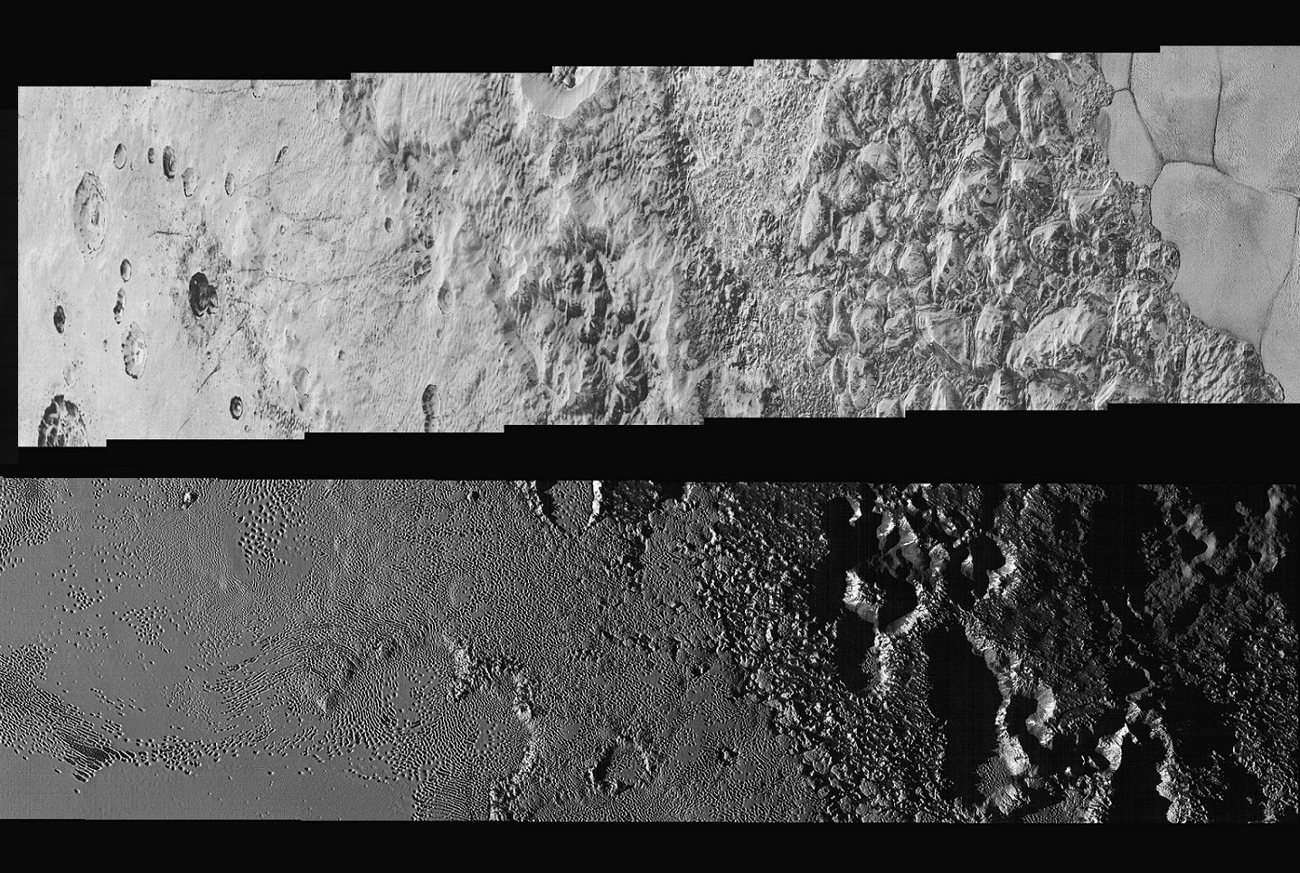
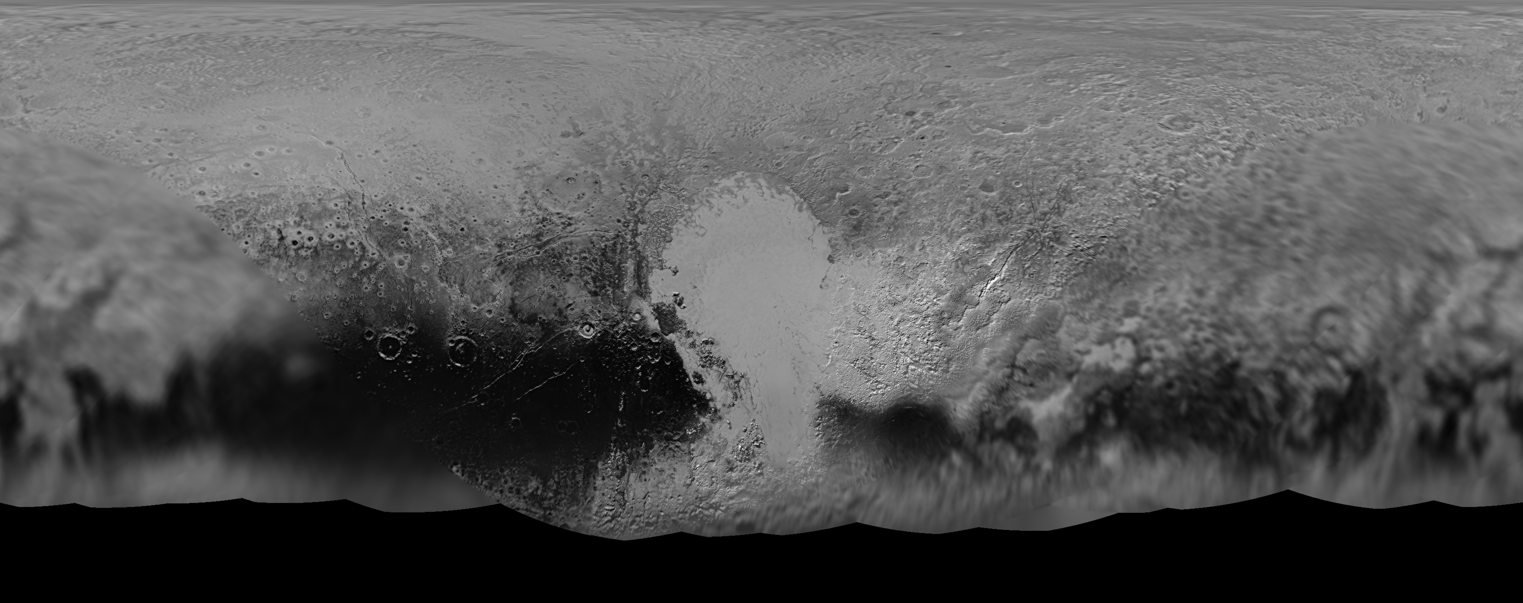
This mosaic of Pluto's surface was created from images taken by the New Horizons probe just 23 minutes before its closest approach. Credit: NASA/JHUAPL/SwRI
The New Horizons mission, which its conducted its historic flyby on July 14th, 2015, has yielded a wealth of scientific data about Pluto. This has included discoveries about Pluto’s size, its mountainous regions, its floating ice hills, and (more recently) how the dwarf planet interacts with solar wind – a discovery which showed that Pluto is actually more planet-like than previously thought.
But beyond revelations about the planet’s size, geography and surface features, it has also provided the most breathtaking, clear, and inspiring images of Pluto and its moons to date. And with this latest release of images taken by the New Horizon‘s Long Range Reconnaissance Imager (LORRI), people here on Earth are being treated to be the best close-up of Pluto yet.
These images, which were taken while the New Horizon’s probe was still 15,850 km (9,850 mi) away from Pluto (just 23 minutes before it made its closest approach), extend across the hemisphere that the probe was facing as it flew past. It shows features ranging from the cratered northern uplands and the mountainous regions in Voyager Terra before slicing through the flatlands of “Pluto’s Heart” – aka. Tombaugh Regio – and ending up in another stretch of rugged highlands.
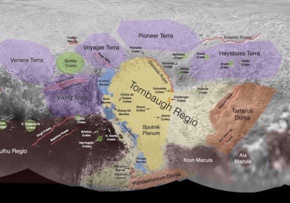
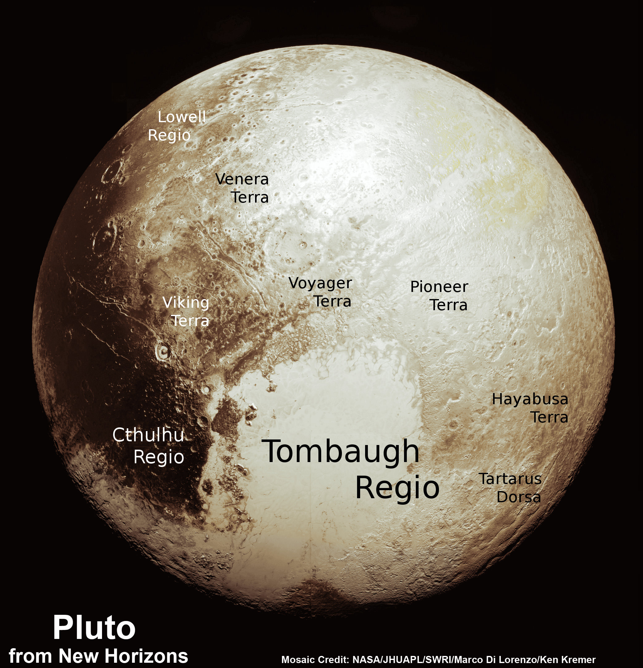
Informal names given to Pluto’s surface features. Credit: earthsky.org
The width of the strip varies as the images pass from north to south, from more than 90 km (55 mi) across at the northern end to about 75 km (45 mi) at its southern point. The perspective also changes, with the view appearing virtually horizontal at the northern end and then shifting to an almost top-down view onto the surface by the end.
The crystal clear photographs that make up the mosaic – which have a resolution of about 80 meters (260 feet) per pixel – offer the most detailed view of Pluto’s surface ever. With this kind of clarity, NASA scientists are able to discern features that were never before visible, and learn things about the kinds of geological processes which formed them.
This includes the chaotic nature of the mountains in the northern hemisphere, and the varied nature of the icy nitrogen plains across Tombaugh Regio – which go from being cellular, to non-cellular, to a cross-bedding pattern. These features are a further indication that Pluto’s surface is the product of a combination of geological forces, such as cryovolcanism, sublimation, geological activity, convection between water and nitrogen ice, and interaction between the surface and atmosphere.
Images snapped by New Horizons’ Long Range Reconnaissance Imager (LORRI) while the probe was still on approach to Pluto were combined with color data from the Ralph instrument to create this global view of Pluto. Credits: NASA/JHUAPL/SwRI
Alan Stern, the principal investigator of the New Horizons mission and the Associate Vice President of Research and Development at the Southwest Research Institute, was especially impressed with this latest find. As he told Universe Today via email:
“This new high resolution image mosaic is the complete highest resolution strip of images New Horizons obtained, and its both eye candy gorgeous and scientifically rich. Think about it— one flyby and we have this mosaic, plus so much more; no dataset like this existed on Mars until we’d flown half a dozen missions there!”
The most distant flyby in the history of space exploration, and yet we’ve obtained more from this one mission than multiple flybys were able to provide from one of Earth’s closest neighbors. Fascinating! And what’s more, new information is expected to be coming from the New Horizons probe until this coming October. To top it off, our scientists are still not finished analyzing all the information the mission collected during its flyby.
The full-resolution image can be viewed here, and be sure to enjoy this NASA video of the mosaic:
View from the surface of Pluto, showing its large moon Charon in the distance. Credit: New York Times
On July 14th, 2015, the New Horizons probe made history as it passed within 12,500 km (7,800 mi) of Pluto, thus making it the first spacecraft to explore the dwarf planet up close. And since this historic flyby, scientists and the astronomy enthusiasts here at Earth have been treated to an unending stream of breathtaking images and scientific discoveries about this distant world.
And thanks to the New York Times and the Universities Space Research Association‘s Lunar and Planetary Institute in Texas, it is now possible to take a virtual reality tour of Pluto. Using the data obtained by the New Horizon’s instruments, users will be able to experience what it is like to explore the planet using their smartphone or computer, or in 3D using a VR headset.
The seven-minute film, titled “Seeking Pluto’s Frigid Heart“, which is narrated by science writer Dennis Overbye of the New York Times – shows viewers what it was like to approach the dwarf planet from the point of the view of the New Horizon’s probe. Upon arrival, they are then able to explore Pluto’s surface, taking in 360 degree views of its icy mountains, heart-shaped plains, and largest moon, Charon.
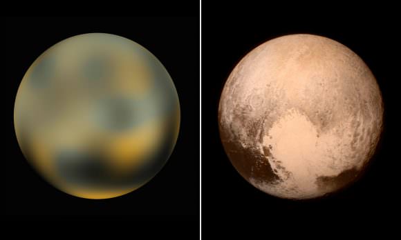
This represents the most detailed and clear look at Pluto to date. A few decades ago, the few maps of Pluto we had were the result of close observations that measured changes in the planet’s total average brightness as it was eclipsed by its largest moon, Charon. Computer processing yielded brightness maps, which were very basic by modern standards.
In the early 2000s, images taken by the Hubble Space Telescope were processed in order to create a more comprehensive view. Though the images were rather undetailed, they offered a much higher resolution view than the previous maps, allowing certain features – like Pluto’s large bright spots and the dwarf planet’s polar regions – to be resolved for the first time.
However, with the arrival of the New Horizons mission, human beings have been finally treated to a close-up view of Pluto and its surface. This included Pluto’s now-famous heart-shaped plains, which were captured by the probe’s Long Range Reconnaissance Imager (LORRI) while it was still several days away from making its closest approach.
Our changing impression of Pluto, represented by images taken by Hubble in 2002-3 (left), and images taken by the New Horizons mission in 2015 (right). Credit: theguardian.com
This was then followed-up by very clear images of its surface features and atmosphere, which revealed floating ice hills, mountains and icy flow plains, and surface clouds composed of methane and tholins. From all of these images, we now know what the surface of this distant world looks like with precision. All of this has allowed scientists here at Earth to reconstruct, in stunning detail, what it would be like to travel to Pluto and stand on its surface.
Amazingly, only half of New Horizon’s images and measurements have been processed so far. And with fresh data expected to arrive until this coming October, we can expect that scientists will be working hard for many years to analyze it all. One can only imagine what else they will learn about this mysterious world. And one can only hope that any news findings will be uploaded to the app (and those like it)!
The VR app can be downloaded at the New York Times VR website, and is available for both Android and Apple devices. It can also be viewed using headset’s like Google Cardboard, a smartphone, and a modified version exists for computer browsers.
NASA’s New Horizons mission science team has produced this updated panchromatic (black-and-white) global map of Pluto. Credits: NASA/JHUAPL/SWRI
NASA’s New Horizons mission science team has produced this updated panchromatic (black-and-white) global map of Pluto. Credits: NASA/JHUAPL/SWRI
The science team leading NASA’s New Horizons mission that unveiled the true nature of Pluto’s long hidden looks during the history making maiden close encounter last July, have published a fresh global map that offers the sharpest and most spectacular glimpse yet of the mysterious, icy world.
The newly updated global Pluto map is comprised of all the highest resolution images transmitted back to Earth thus far and provides the best perspective to date.
Click on the lead image above to enjoy Pluto revealed at its finest thus far. Click on this link to view the highest resolution version.
Prior to the our first ever flyby of the Pluto planetary system barely 8 months ago, the planet was nothing more than a fuzzy blob with very little in the way of identifiable surface features – even in the most powerful telescopic views lovingly obtained from the Hubble Space Telescope (HST).
Dead center in the new map is the mesmerizing heart shaped region informally known as Tombaugh Regio, unveiled in all its glory and dominating the diminutive world.
The panchromatic (black-and-white) global map of Pluto published by the team includes the latest images received as of less than one week ago on April 25.
The images were captured by New Horizons’ high resolution Long Range Reconnaissance Imager (LORRI).
The science team is working on assembling an updated color map.
During its closest approach at approximately 7:49 a.m. EDT (11:49 UTC) on July 14, 2015, the New Horizons spacecraft swoop to within about 12,500 kilometers (nearly 7,750 miles) of Pluto’s surface and about 17,900 miles (28,800 kilometers) from Charon, the largest moon.
The map includes all resolved images of Pluto’s surface acquired in the final week of the approach period ahead of the flyby starting on July 7, and continuing through to the day of closest approach on July 14, 2015 – and transmitted back so far.
The pixel resolutions are easily seen to vary widely across the map as you scan the global map from left to right – depending on which Plutonian hemisphere was closest to the spacecraft during the period of close flyby.
They range from the highest resolution of 770 feet (235 meters), at center, to 18 miles (30 kilometers) at the far left and right edges.
The Charon-facing hemisphere (left and right edges of the map) had a pixel resolution of 18 miles (30 kilometers).
“This non-encounter hemisphere was seen from much greater range and is, therefore, in far less detail,” noted the team.
However the hemisphere facing New Horizons during the spacecraft’s closest approach on July 14, 2015 (map center) had a far higher pixel resolution reaching to 770 feet (235 meters).
Coincidentally and fortuitously the spectacularly diverse terrain of Tombaugh Regio and the Sputnik Planum area of the hearts left ventricle with ice flows and volcanoes, mountains and river channels was in the region facing the camera and sports the highest resolution imagery.
See below a newly released shaded relief map of Sputnik Planum.
This new shaded relief view of the region surrounding the left side of Pluto’s heart-shaped feature – informally named Sputnik Planum – shows that the vast expanse of the icy surface is on average 2 miles (3 kilometers) lower than the surrounding terrain. Angular blocks of water ice are “floating” in the bright deposits of softer, denser solid nitrogen. Credits: NASA/JHUAPL/SwRI
“Sputnik Planum – shows that the vast expanse of the icy surface is on average 2 miles (3 kilometers) lower than the surrounding terrain. Angular blocks of water ice along the western edge of Sputnik Planum can be seen “floating” in the bright deposits of softer, denser solid nitrogen,” according to the team.
Even more stunning images and groundbreaking data will continue streaming back from New Horizons until early fall, across over 3 billion miles of interplanetary space.
Thus the global map of Pluto will be periodically updated.
Its taking over a year to receive the full complement of some 50 gigabits of data due to the limited bandwidth available from the transmitter on the piano-shaped probe as it hurtled past Pluto, its largest moon Charon and four smaller moons.
Pluto is the last planet in our solar system to be visited in the initial reconnaissance of planets by spacecraft from Earth since the dawn of the Space Age.
This new global mosaic view of Pluto was created from the latest high-resolution images to be downlinked from NASA’s New Horizons spacecraft and released on Sept. 11, 2015. The images were taken as New Horizons flew past Pluto on July 14, 2015, from a distance of 50,000 miles (80,000 kilometers). This new mosaic was stitched from over two dozen raw images captured by the LORRI imager and colorized. Annotated with informal place names. Credits: NASA/Johns Hopkins University Applied Physics Laboratory/Southwest Research Institute/Marco Di Lorenzo/Ken Kremer/kenkremer.com
New Horizons remains on target to fly by a second Kuiper Belt Object (KBO) on Jan. 1, 2019 – tentatively named PT1, for Potential Target 1. It is much smaller than Pluto and was recently selected based on images taken by NASA’s Hubble Space Telescope.
Stay tuned here for Ken’s continuing Earth and planetary science and human spaceflight news.
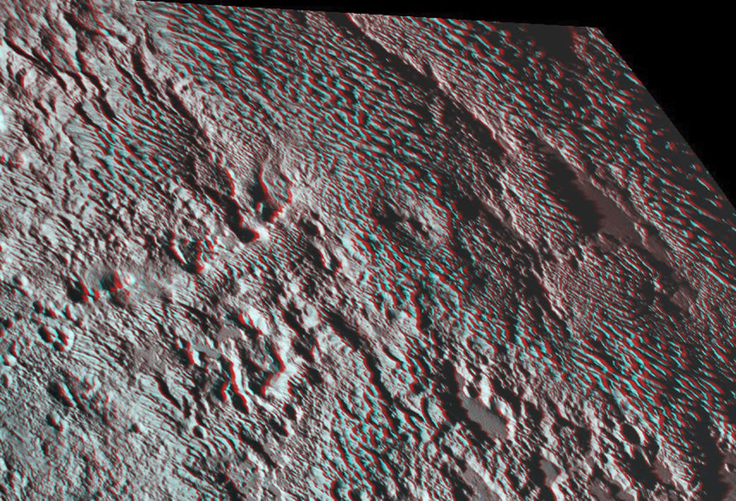
The amazing stereo view of a broad area informally named Tartarus Dorsa combines two images from the Ralph/Multispectral Visible Imaging Camera (MVIC) taken about 14 minutes apart on July 14, 2015. The first was taken when New Horizons was 16,000 miles (25,000 kilometers) away from Pluto, the second when the spacecraft was 10,000 miles (about 17,000 kilometers) away. Credits: NASA/JHUAPL/SwRI
The amazing stereo view of a broad area informally named Tartarus Dorsa combines two images from the Ralph/Multispectral Visible Imaging Camera (MVIC) taken about 14 minutes apart on July 14, 2015. The first was taken when New Horizons was 16,000 miles (25,000 kilometers) away from Pluto, the second when the spacecraft was 10,000 miles (about 17,000 kilometers) away. Credits: NASA/JHUAPL/SwRI
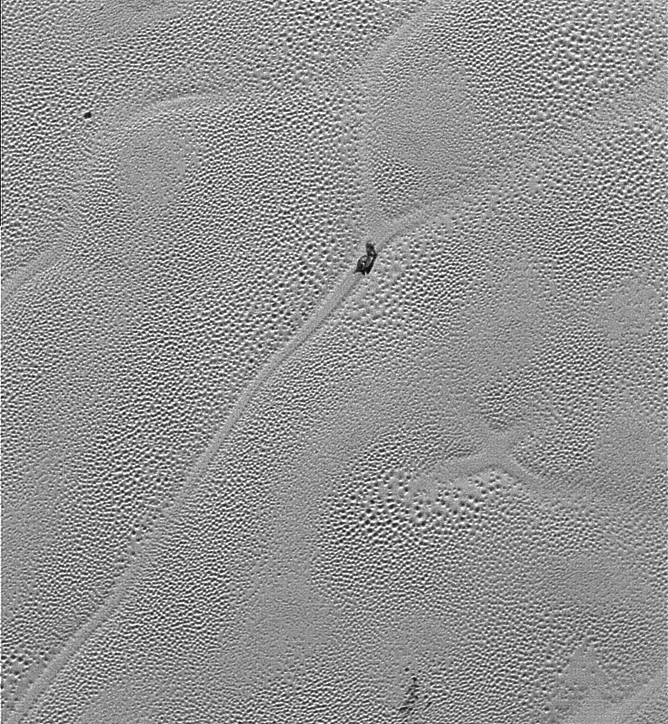
It’s time to whip out your 3-D glasses to enjoy and scrutinize the remarkable detail of spectacular terrain revealed in a new high resolution stereo image of Pluto – King of the Kuiper Belt! – taken by NASA’s New Horizons spacecraft.
The amazing new stereo Plutonian image focuses on an area dominated by a mysterious feature that geologists call ‘bladed’ terrain – seen above – and its unlike anything seen elsewhere in our solar system.
Its located in a broad region of rough highlands informally known as Tartarus Dorsa – situated to the east of the Pluto’s huge heart shaped feature called Tombaugh Regio. The best resolution is approximately 1,000 feet (310 meters).
The stereo view combines a pair of images captured by New Horizons Ralph/Multispectral Visible Imaging Camera (MVIC) science instruments. They were taken about 14 minutes apart on during history making first ever flyby of the Pluto planetary system on July 14, 2015.
The first was taken when New Horizons was 16,000 miles (25,000 kilometers) away from Pluto, the second when the spacecraft was 10,000 miles (about 17,000 kilometers) away.
The blades align from north to south, typically reach up to about 550 yards (500 meters) high and are spaced about 2-4 miles (3-5 kilometers). Thus they are among the planets steepest features. They are “perched on a much broader set of rounded ridges that are separated by flat valley floors,” according to descriptions from the New Horizons science team.
This color image of Pluto taken by NASA’s New Horizons spacecraft shows rounded and bizarrely textured mountains, informally named the Tartarus Dorsa, rise up along Pluto’s terminator and show intricate but puzzling patterns of blue-gray ridges and reddish material in between. This view, roughly 330 miles (530 kilometers) across, combines blue, red and infrared images taken by the Ralph/Multispectral Visual Imaging Camera (MVIC) on July 14, 2015, and resolves details and colors on scales as small as 0.8 miles (1.3 kilometers). Credits: NASA/JHUAPL/SWRI
Mission scientists have also noted that the bladed terrain has the texture of “snakeskin” owing to their “scaly raised relief.”
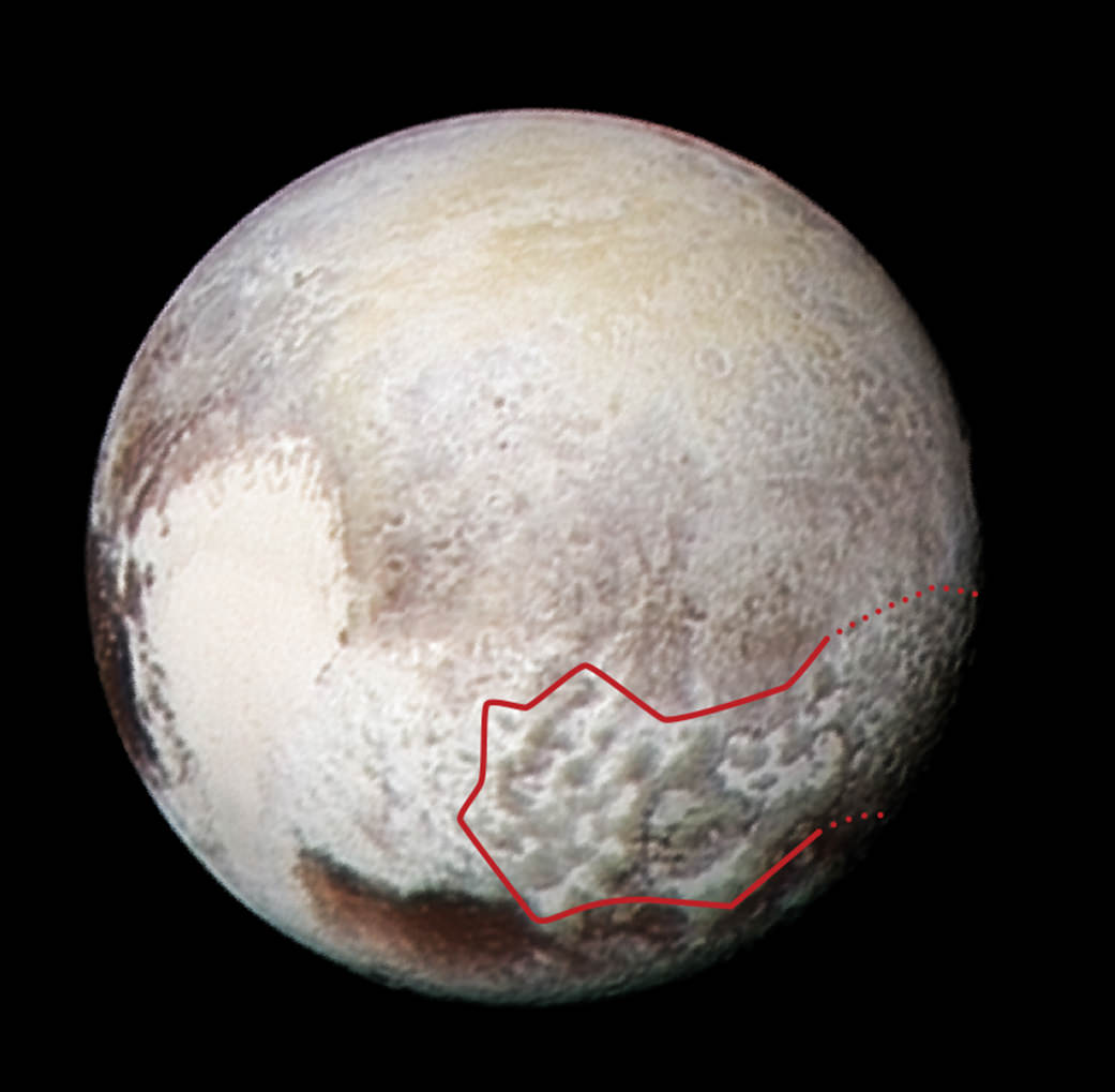
In the companion global image from NASA (below), the bladed terrain is outlined in red and shown to extend quite far to the east of Tombaugh Regio.
The composite image was taken on July 13, 2015, the day before the closest approach flyby, when the probe was farther away thus shows lower resolution. It combines a pair of images from two of the science instruments – a Ralph/Multispectral Visible Imaging Camera (MVIC) color scan and an image from the Long Range Reconnaissance Imager (LORRI).
This global view of Pluto combines a Ralph/Multispectral Visible Imaging Camera (MVIC) color scan and an image from the Long Range Reconnaissance Imager (LORRI), both obtained on July 13, 2015 – the day before New Horizons’ closest approach. The red outline marks the large area of mysterious, bladed terrain extending from the eastern section of the large feature informally named Tombaugh Regio. Credits: NASA/JHUAPL/SwRI
The MVIC scan was taken from a range of 1 million miles (1.6 million kilometers), at a resolution of 20 miles (32 kilometers) per pixel. The corresponding LORRI image was obtained from roughly the same range, but has a higher spatial resolution of 5 miles (8 kilometers) per pixel, say officials.
Scientists have developed several possible theories about the origins of the bladed terrain, including erosion from evaporating ices or deposition of methane ices.
Measurements from the Linear Etalon Imaging Spectral Array (LEISA) instrument reveal that that this region “is composed of methane (CH4) ice with a smattering of water,” reports New Horizons researcher Orkan Umurhan.
He speculates that “the material making up the bladed terrain is a methane clathrate. A clathrate is a structure in which a primary molecular species (say water, or H2O) forms a crystalline ‘cage’ to contain a guest molecule (methane or CH4, for example).”
But the question of whether that methane ice is strong enough to maintain the steep walled snakeskin features, will take much more research to determine a conclusive answer.
Umurhan suggests that more research could help determine if the “methane clathrates in the icy moons of the outer solar system and also in the Kuiper Belt were formed way back before the solar system formed – i.e., within the protosolar nebula – potentially making them probably some of the oldest materials in our solar system.”
Pluto continues to amaze and surprise us as the data streams back to eagerly waiting scientists on Earth over many more months to come – followed by years and decades of painstaking analysis.
This new global mosaic view of Pluto was created from the latest high-resolution images to be downlinked from NASA’s New Horizons spacecraft and released on Sept. 11, 2015. The images were taken as New Horizons flew past Pluto on July 14, 2015, from a distance of 50,000 miles (80,000 kilometers). This new mosaic was stitched from over two dozen raw images captured by the LORRI imager and colorized. Annotated with informal place names. Credits: NASA/Johns Hopkins University Applied Physics Laboratory/Southwest Research Institute/Marco Di Lorenzo/Ken Kremer/kenkremer.com
During New Horizons flyby on July 14, 2015, it discovered that Pluto is the biggest object in the outer solar system and thus the ‘King of the Kuiper Belt.”
The Kuiper Belt comprises the third and outermost region of worlds in our solar system.
Pluto is the last planet in our solar system to be visited in the initial reconnaissance of planets by spacecraft from Earth since the dawn of the Space Age.
New Horizons remains on target to fly by a second Kuiper Belt Object (KBO) on Jan. 1, 2019 – tentatively named PT1, for Potential Target 1. It is much smaller than Pluto and was recently selected based on images taken by NASA’s Hubble Space Telescope.
Stay tuned here for Ken’s continuing Earth and planetary science and human spaceflight news.
Learn more about NASA Mars rovers, Orion, SLS, ISS, Orbital ATK, ULA, SpaceX, Boeing, Space Taxis, NASA missions and more at Ken’s upcoming outreach events:
Apr 9/10: “NASA and the Road to Mars Human Spaceflight programs” and “Curiosity explores Mars” at NEAF (NorthEast Astronomy and Space Forum), 9 AM to 5 PM, Suffern, NY, Rockland Community College and Rockland Astronomy Club – http://rocklandastronomy.com/neaf.html
Apr 12: Hosting Dr. Jim Green, NASA, Director Planetary Science, for a Planetary sciences talk about “Ceres, Pluto and Planet X” at Princeton University; 7:30 PM, Amateur Astronomers Assoc of Princeton, Peyton Hall, Princeton, NJ – http://www.princetonastronomy.org/
Apr 17: “NASA and the Road to Mars Human Spaceflight programs”- 1:30 PM at Washington Crossing State Park, Nature Center, Titusville, NJ – http://www.state.nj.us/dep/parksandforests/parks/washcros.html
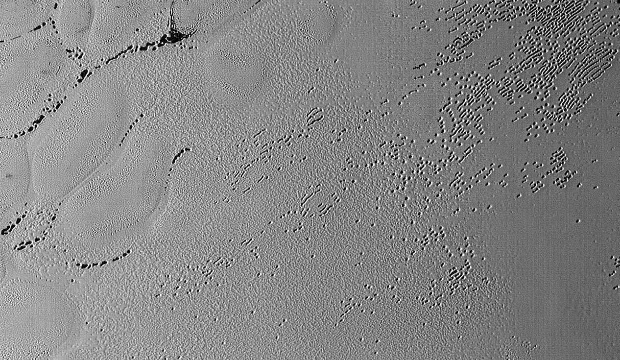
“X” marks the spot in this image transmitted to Earth on Dec. 24, 2015 from the Long Range Reconnaissance Imager (LORRI) from NASA’s New Horizons’ showing the highest-resolution swath of Pluto at the center of Sputnik Planum, the informally named plain that forms the left side of Pluto’s “heart.” The pattern of polygonal cells stems from the slow thermal convection of the nitrogen-dominated ices. Also visible is a a dirty block of water ice “floating” in denser solid nitrogen. Credits: NASA/JHUAPL/SwRI
“X” marks the spot that’s illustrative of “convective churning” resulting from subsurface planetary heating, as seen in a fascinating new super high resolution image received from NASA’s New Horizons spacecraft on Christmas Eve, Dec. 24, 2015. Its situated at the very center of the left ventricle of Pluto’s huge “heart” – an icy flow plain that’s informally named “Sputnik Planum.”
The “X” feature – see image above – is located in an area of intersecting cells, shaped like polygons, on the plains of “Sputnik Planum” which are mostly comprised of frozen nitrogen ices.
This image was taken by the Long Range Reconnaissance Imager (LORRI) on NASA's New Horizons spacecraft shortly before closest approach to Pluto on July 14, 2015; it resolves details as small as 270 yards (250 meters). The scene shown is about 130 miles (210 kilometers) across. The sun illuminates the scene from the left, and north is to the upper left.
Credits: NASA/JHUAPL/SwRI
A brand new batch of Pluto and Charon photos showed up today on the New Horizons LORRI (LOng-Range Reconnaissance Imager) site. The photos were taken during the close flyby of the system on July 14, 2015 and show rich detail including craters and parallel cracks on Charon and thousands of small pits punctuating Pluto’s nitrogen ice landscape. Have at ’em!
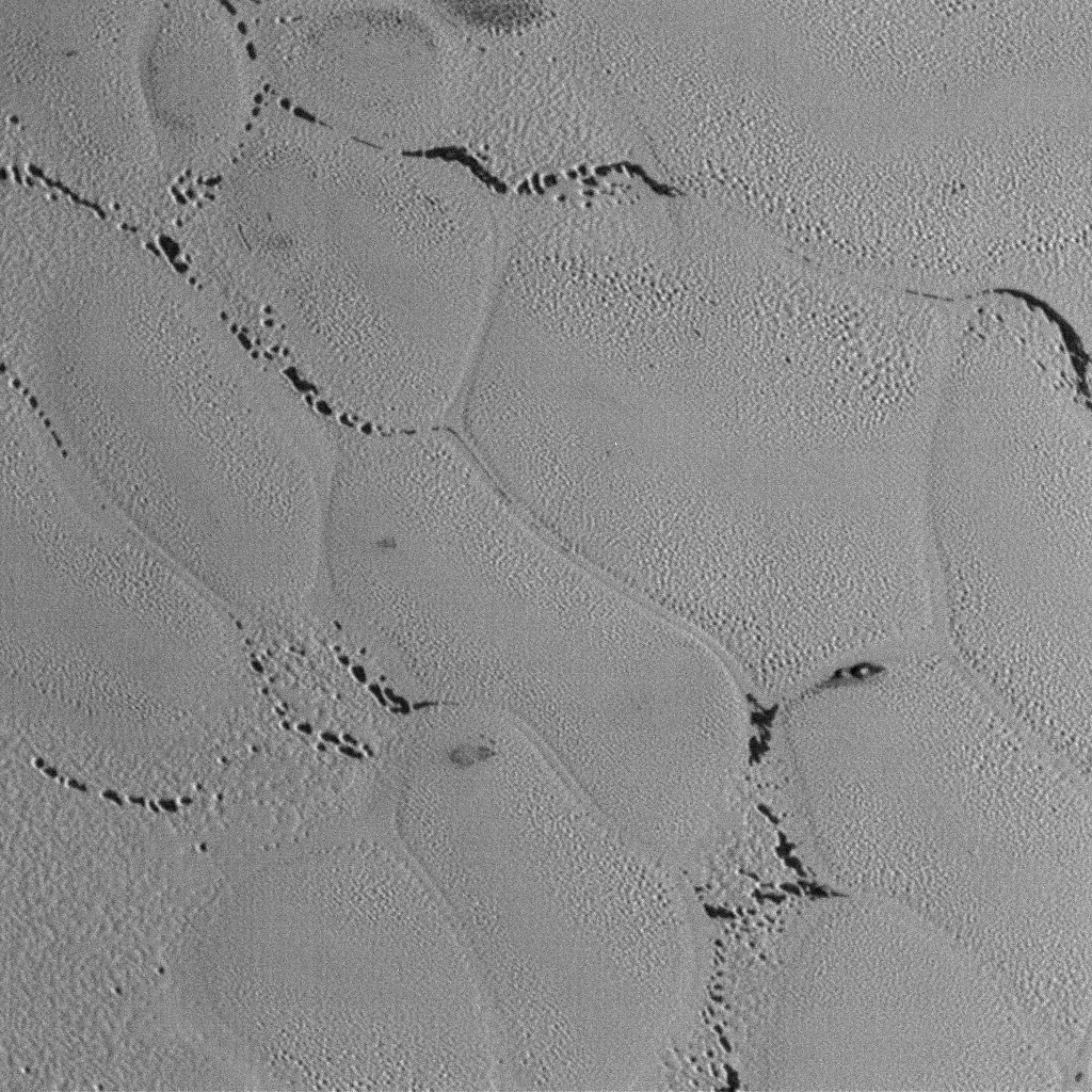
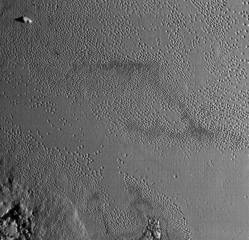
This wider view shows the snakeskin-like textured surface of Pluto’s icy plains riddled with small pits. It almost looks like the dark areas in the sinuous channels between the mounds were once covered with frost or ice that has since sublimated away. They look similar to the polar regions on Mars where carbon dioxide frost burns off in the spring to reveal darker material beneath. Credit: NASA/JHUAPL/SwRI
The first couple images feature the region informally known as Sputnik Planum. According to a releasefrom NASA today, scientists think the region is composed of volatile ices such as solid nitrogen. They theorize that the pits and troughs – typically hundreds of meters across and tens of meters deep – are possibly formed by sublimation or evaporation of these ices in Pluto’s thin atmosphere. Still, their curious shapes and alignments remain a mystery. Adding to the intrigue is that even when seen up close, no impact craters are visible, testifying to the icy plain’s extreme geologic youth.
By the way, there are more images at the LORRI link at top. I picked a representative selection but I encourage you to visit and explore.
Now that’s what I call getting a photo in low light. Sunlight scrapes across rugged mountains as well as highlight the ubiquitous pitted terrain. Credit: NASA/JHUAPL/SwRI
Life’s definitely the pits on Pluto’s Tombaugh Regio. This photo shows the fainter “ghost” pits well. Is ice filling them in or are we seeing the beginning of a pit’s formation? Credit: NASA/JHUAPL/SwRI
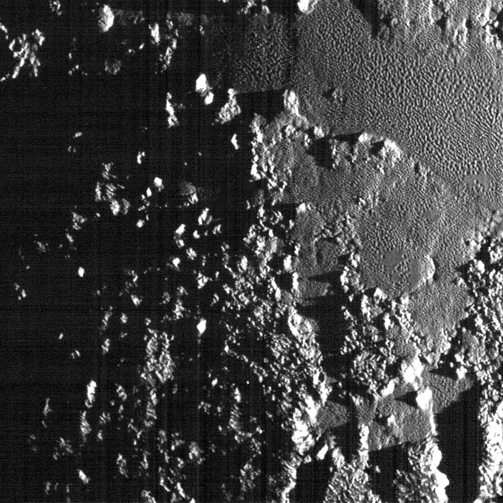
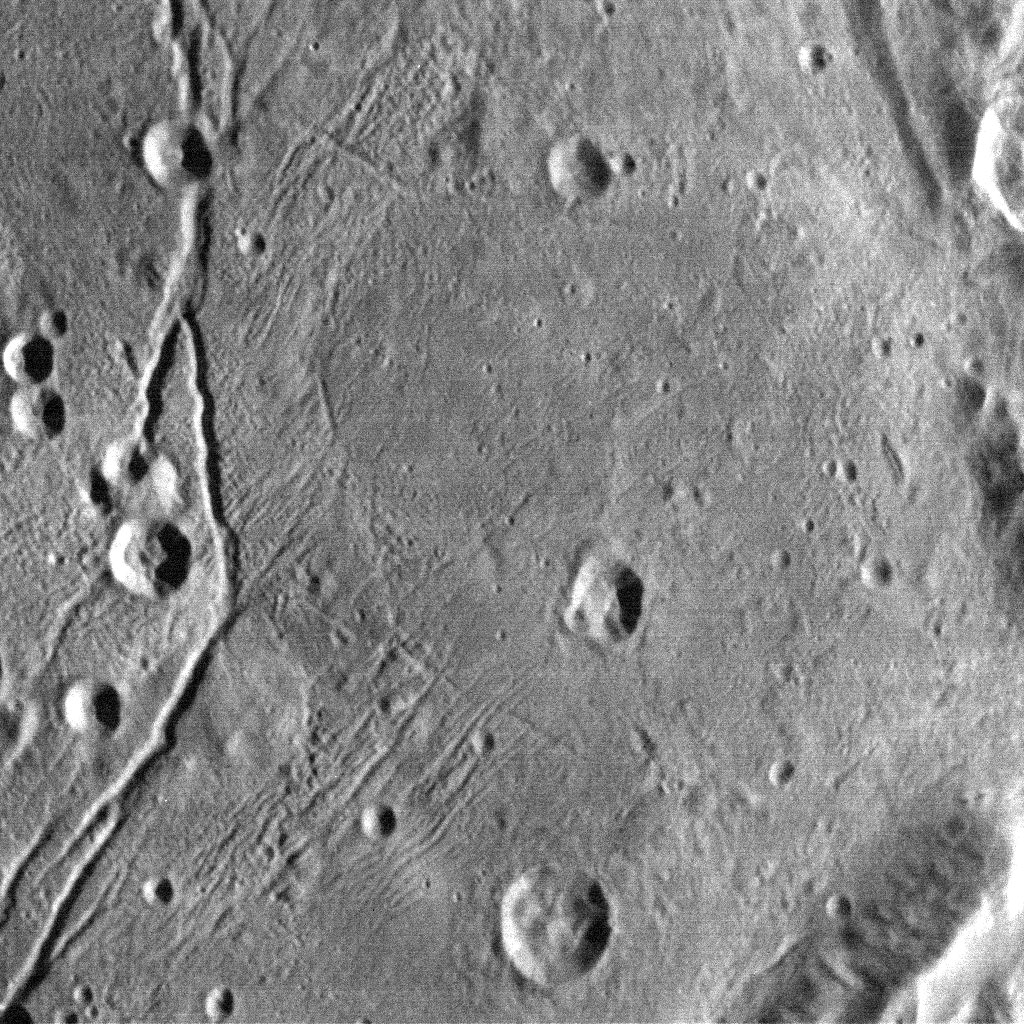
A fine view of Pluto’s largest moon Charon and its vast canyon system. Credit: NASA/JHUAPL/SwRI
Looking over Charon’s dark north polar region, the border of which is highlighted by several beautiful rayed craters. Not that it’s necessarily related, but the dark spot reminds me of a lunar mare or sea. On the moon, cracks in the crust allowed lava to fill gigantic basins to create the maria. Could material from beneath Charon have bubbled up to fill an ancient impact? Credit: NASA/JHUAPL/SwRI
Speaking of the Moon, the large cracks at left resemble lunar rills, some of which formed through faulting / fracturing and others as conduits for lava flows. The multiple, fine cracks are interesting. Credit: NASA/JHUAPL/SwRI
Splendid rayed crater with an interesting contrast between dark and light ejecta. Credit: NASA/JHUAPL/SwRI
A busy region on Charon, the meeting place of different terrains. Credit: NASA/JHUAPL/SwRI
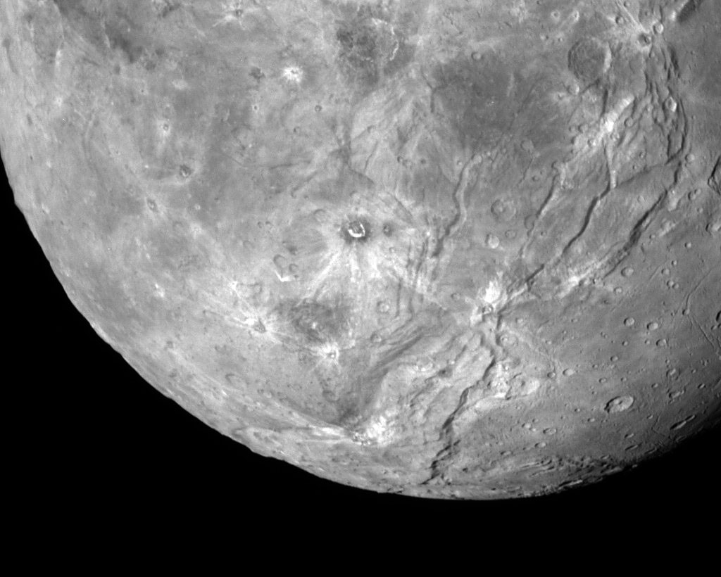
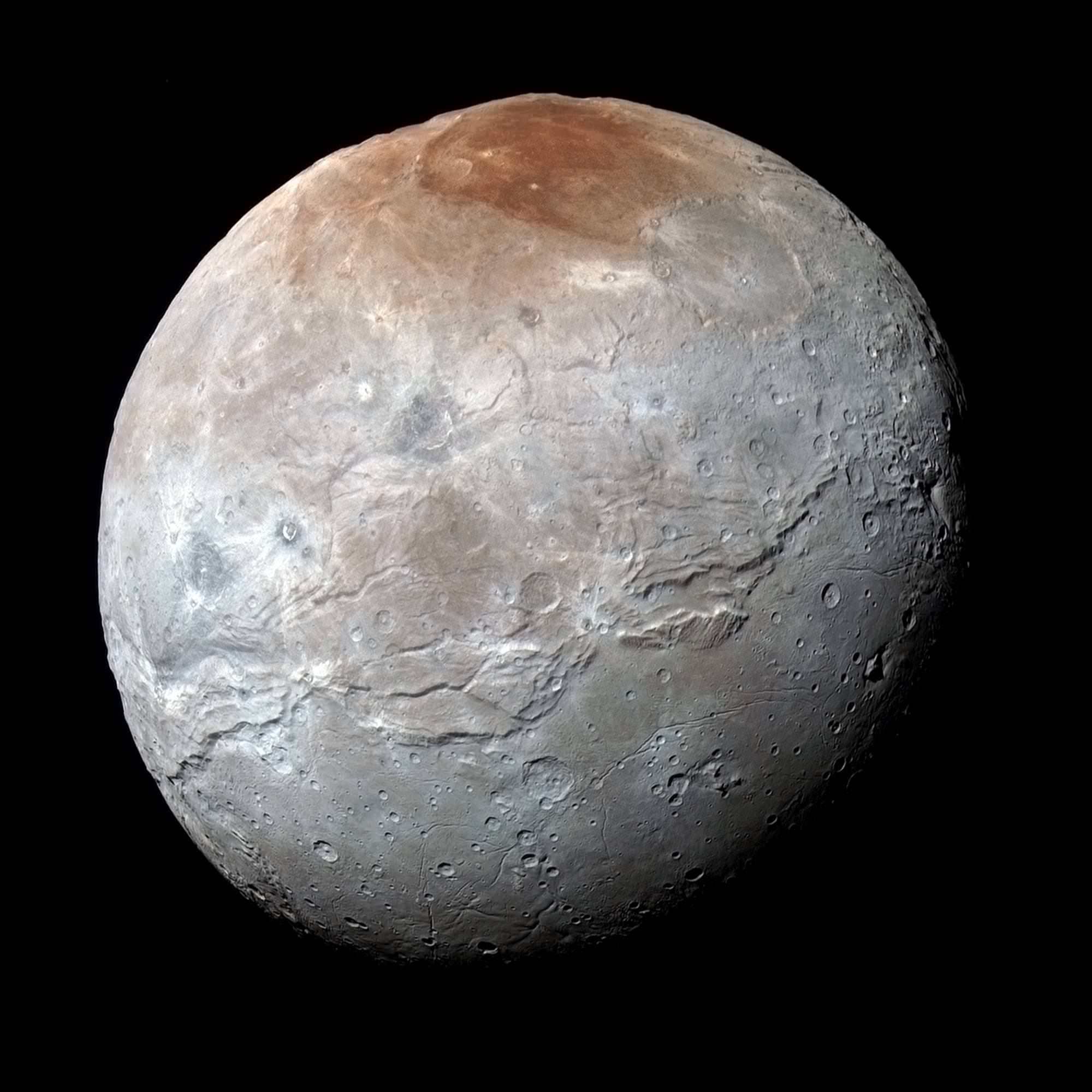
Charon in Enhanced Color. NASA's New Horizons captured this high-resolution enhanced color view of Charon just before closest approach on July 14, 2015. The image combines blue, red and infrared images taken by the spacecraft’s Ralph/Multispectral Visual Imaging Camera (MVIC); the colors are processed to best highlight the variation of surface properties across Charon. Charon’s color palette is not as diverse as Pluto’s; most striking is the reddish north (top) polar region, informally named Mordor Macula. Charon is 754 miles (1,214 kilometers) across; this image resolves details as small as 1.8 miles (2.9 kilometers). Credits: NASA/JHUAPL/SwRI
Charon in Enhanced Color with Grand Canyon
NASA’s New Horizons captured this high-resolution enhanced color view of Charon and its Grand Canyon just before closest approach on July 14, 2015. The image combines blue, red and infrared images taken by the spacecraft’s Ralph/Multispectral Visual Imaging Camera (MVIC); the colors are processed to best highlight the variation of surface properties across Charon. Charon’s color palette is not as diverse as Pluto’s; most striking is the reddish north (top) polar region, informally named Mordor Macula. Charon is 754 miles (1,214 kilometers) across; this image resolves details as small as 1.8 miles (2.9 kilometers). Credits: NASA/JHUAPL/SwRI[/caption]
Charon suffered such a surprisingly violent past of titanic upheavals that they created a humongous canyon stretching across the entire face of Pluto’s largest moon – as revealed in a fresh batch of images just returned from NASA’s New Horizons spacecraft.
We have been agog in amazement these past few weeks as New Horizons focused its attention on transmitting astounding high resolution imagery and data of Pluto, captured during mankind’s history making first encounter with our solar systems last unexplored planet on July 14, 2015, at a distance of 7,750 miles (12,500 kilometers).
“You’ll love this,” said New Horizons Principal Investigator Alan Stern of the Southwest Research Institute, Boulder, Colorado, in a blog posting.
Indeed researches say Charon’s tortured landscape of otherworldly canyons, mountains and more far exceeds scientists preconceived notions of a “monotonous, crater-battered world; instead, they’re finding a landscape covered with mountains, canyons, landslides, surface-color variations and more.”
“We thought the probability of seeing such interesting features on this satellite of a world at the far edge of our solar system was low,” said Ross Beyer, an affiliate of the New Horizons Geology, Geophysics and Imaging (GGI) team from the SETI Institute and NASA Ames Research Center in Mountain View, California, in a statement.
“But I couldn’t be more delighted with what we see.”
Measuring 754 miles (1,214 kilometers) across, Charon is half the diameter of Pluto and forms a double planet system. Charon also ranks as the largest satellite relative to its planet in the solar system. By comparison, Earth’s moon is one quarter the size of our home planet.
The new images of the Pluto-facing hemisphere of Charon were taken by New Horizons’ Long Range Reconnaissance Imager (LORRI) and the Ralph/Multispectral Visual Imaging Camera (MVIC) during the July 14 flyby and downlinked over about the past week and a half.
They reveal details of a belt of fractures and canyons just north of the moon’s equator.
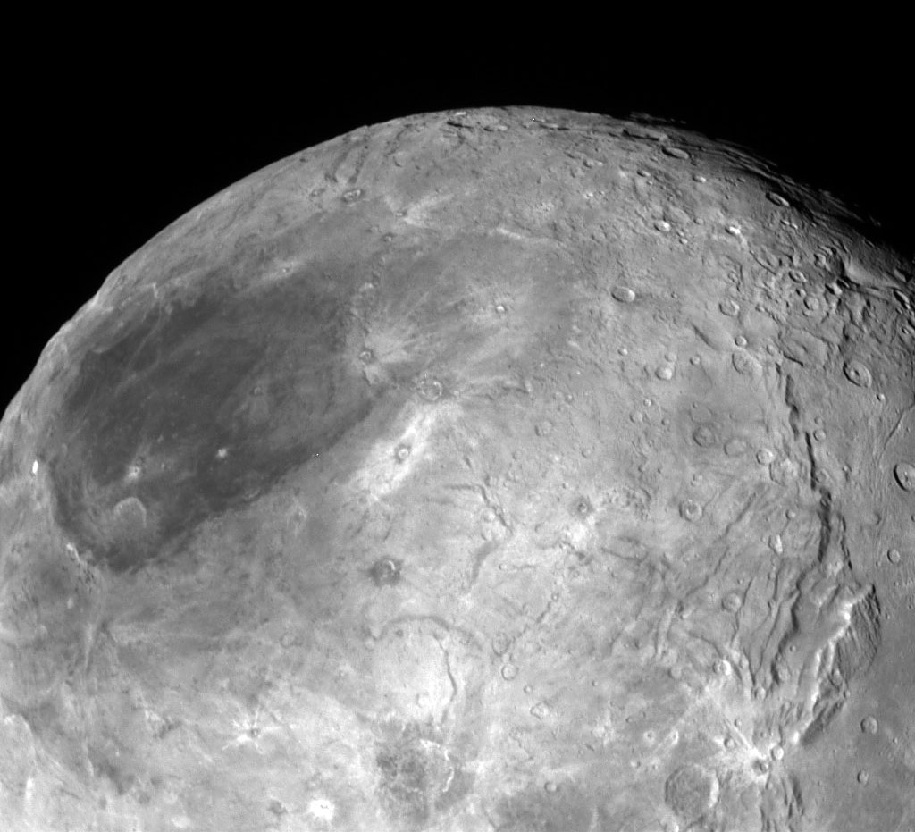
High-resolution images of Charon were taken by the Long Range Reconnaissance Imager on NASA’s New Horizons spacecraft, shortly before closest approach on July 14, 2015, and overlaid with enhanced color from the Ralph/Multispectral Visual Imaging Camera (MVIC). Charon’s cratered uplands at the top are broken by series of canyons, and replaced on the bottom by the rolling plains of the informally named Vulcan Planum. The scene covers Charon’s width of 754 miles (1,214 kilometers) and resolves details as small as 0.5 miles (0.8 kilometers). Credits: NASA/JHUAPL/SwRI
The “Grand Canyon of Charon” stretches more than 1,000 miles (1,600 kilometers) across the entire face of Charon visible in the new images. Furthermore the deep canyon probably extends onto the far side of Pluto and hearkens back to Valles Marineris on Mars.
“It looks like the entire crust of Charon has been split open,” said John Spencer, deputy lead for GGI at the Southwest Research Institute in Boulder, Colorado, in a statement.
“With respect to its size relative to Charon, this feature is much like the vast Valles Marineris canyon system on Mars.”
Charon’s “Grand Canyon” is four times as long as the Grand Canyon of the United States. Plus its twice as deep in places. “These faults and canyons indicate a titanic geological upheaval in Charon’s past,” according to the New Horizons team.
This composite of enhanced color images of Pluto (lower right) and Charon (upper left), was taken by NASA’s New Horizons spacecraft as it passed through the Pluto system on July 14, 2015. This image highlights the striking differences between Pluto and Charon. The color and brightness of both Pluto and Charon have been processed identically to allow direct comparison of their surface properties, and to highlight the similarity between Charon’s polar red terrain and Pluto’s equatorial red terrain. Pluto and Charon are shown with approximately correct relative sizes, but their true separation is not to scale. The image combines blue, red and infrared images taken by the spacecraft’s Ralph/Multispectral Visual Imaging Camera (MVIC). Credits: NASA/JHUAPL/SwRI
Another intriguing finding is the area south of the canyon is much smoother, with fewer craters and may have been resurfaced by a type of “cryovolcanism.”
The southern plains are informally named “Vulcan Planum” and may be much younger.
“The team is discussing the possibility that an internal water ocean could have frozen long ago, and the resulting volume change could have led to Charon cracking open, allowing water-based lavas to reach the surface at that time,” said Paul Schenk, a New Horizons team member from the Lunar and Planetary Institute in Houston.
The piano shaped probe gathered about 50 gigabits of data as it hurtled past Pluto, its largest moon Charon and four smaller moons.
Barely 5 or 6 percent of the 50 gigabits of data captured by New Horizons has been received by ground stations back on Earth due to the slow downlink rate.
Stern says it will take about a year for all the data to get back. Many astounding discoveries await.
“I predict Charon’s story will become even more amazing!” said mission Project Scientist Hal Weaver, of the Johns Hopkins University Applied Physics Laboratory in Laurel, Maryland.
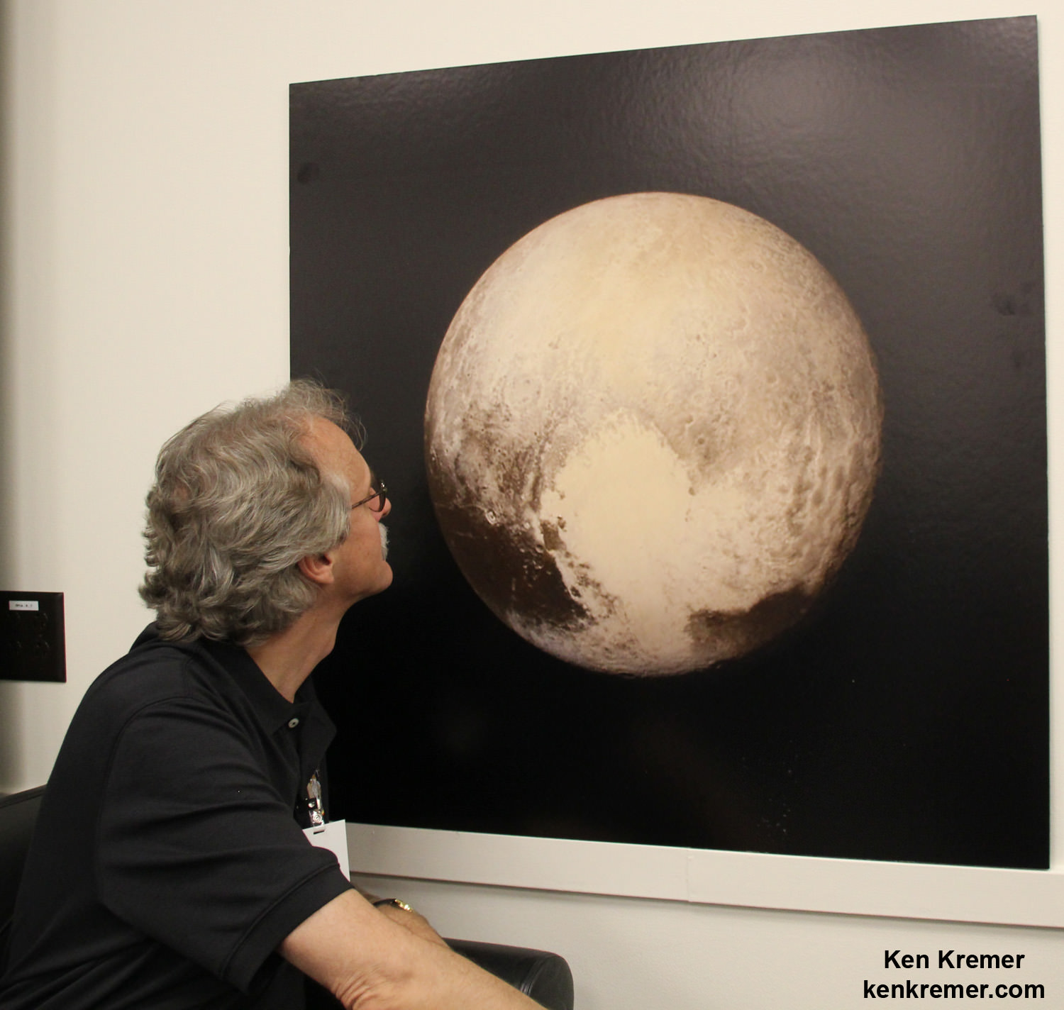
New Horizons science team co-investigator John Spencer examines print of the newest Pluto image taken on July 13, 2015 after the successful Pluto flyby. Credit: Ken Kremer/kenkremer.com
Stay tuned here for Ken’s continuing Earth and planetary science and human spaceflight news.
This new global mosaic view of Pluto was created from the latest high-resolution images to be downlinked from NASA’s New Horizons spacecraft and released on Sept. 11, 2015. The images were taken as New Horizons flew past Pluto on July 14, 2015, from a distance of 50,000 miles (80,000 kilometers). This new mosaic was stitched from over two dozen raw images captured by the LORRI imager and colorized. Annotated with informal place names. Credits: NASA/Johns Hopkins University Applied Physics Laboratory/Southwest Research Institute/Marco Di Lorenzo/Ken Kremer/kenkremer.com


