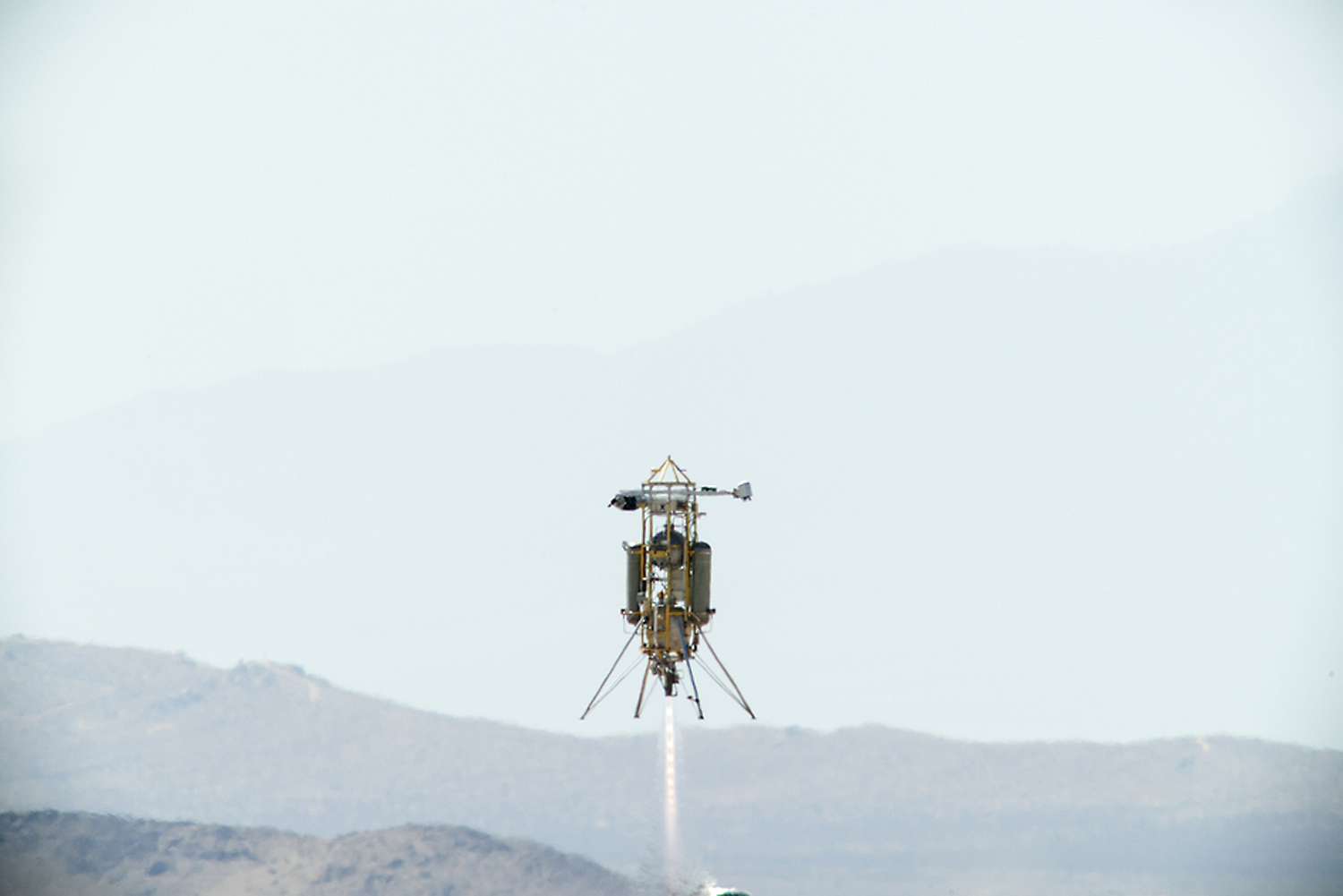
NASA is testing autonomous lunar launch systems in the Mojave Desert in California. Pictured is a tethered test of Draper relative terrain navigation system on a Masten Space Systems Zodiac rocket. Image Credit: NASA/Masten Space Systems
In anticipation of many Moon landings to come, NASA is testing an autonomous lunar landing system in the Mojave Desert in California. The system is called a “terrain relative navigation system.” It’s being tested on a launch and landing of a Zodiac rocket, built by Masten Space Systems. The test will happen on Wednesday, September 11th.
To really study something, you want to reach out and touch it. But what can you do if you’re separated by a huge distance? You reach out with electromagnetic or sound waves and watch how they bounce back. Thanks to radar, sonar and lidar.
If you would like to join the Weekly Space Hangout Crew, visit their site here and sign up. They’re a great team who can help you join our online discussions!
The Phoenix Mars Lander used a lidar device built by Teledyne Optech to detect snow in the Martian atmosphere in 2008. Credits: NASA
Oklahoma’s Beaver River is an incredibly historic place. Anthropologists estimate that as early as 10,500 years ago, human beings hunted bison in the region. Being without horses, the hunter-gatherers would funnel herds into narrow, dead-end gullies cut into the hillside by the river. Once there, they would kill them en masse, taking the meat and organs and leaving the skeletons behind.
Sadly, no visible trace of this history remains in the region today, thanks to weathering and erosion. But according to a recent story released by NASA, the same technology that powers the Origins, Spectral Interpretation, Resource Identification, Security-Regolith Explorer (OSIRIS-REx) mission has made the ancient history of this region visible for all to see.
Having launched back in September of 2016, the robotic spacecraft OSIRIS-REx is scheduled to rendezvous with the Near-Earth Asteroid Bennu in 2023. The purpose of the mission is to obtain samples of the carbonaceous object and return them to Earth, thus helping scientists to get a better understanding of the formation and evolution of the Solar System, as well as the source of organic compounds that led to the formation of life on Earth.
Once it reaches Bennu, it will rely on light-detection and ranging (aka. lidar) to map the asteroid and help the mission team select a landing site. This technology uses one or more lasers to send out short pulses that bounce off of nearby objects. The instrument then measures how long it takes for the signal to return to get an accurate assessment of distance and generate topographical information.
The OSIRIS-REx Laser Altimeter (OLA) instrument was designed by Teledyne Optech, a company that has worked with NASA many times in the past. Their work includes the laser instrument that was used by the Phoenix Lander to detect snow in the Martian atmosphere back in 2008. And more recently, it was used by an archeological research team in the Beaver River area to create a detailed picture of its past.
Using an airborne version of the Teledyne Optech lidar device, the team was able to create a 3-D model of the surface. They were also able to generate as a ‘bare-earth” version of the area that showed what the land looked like without all of the concealing features – i.e. rocks, trees and grass – that hide its past.
In so doing, they were able to figure out where they should dig to find evidence that the region was once a major hunting ground. As Paul LaRoque, vice president of special projects at Teledyne Optech, explained, this process allowed the archaeologists to “see structures or features that were so overgrown that they wouldn’t be obvious at all to someone on the ground.”
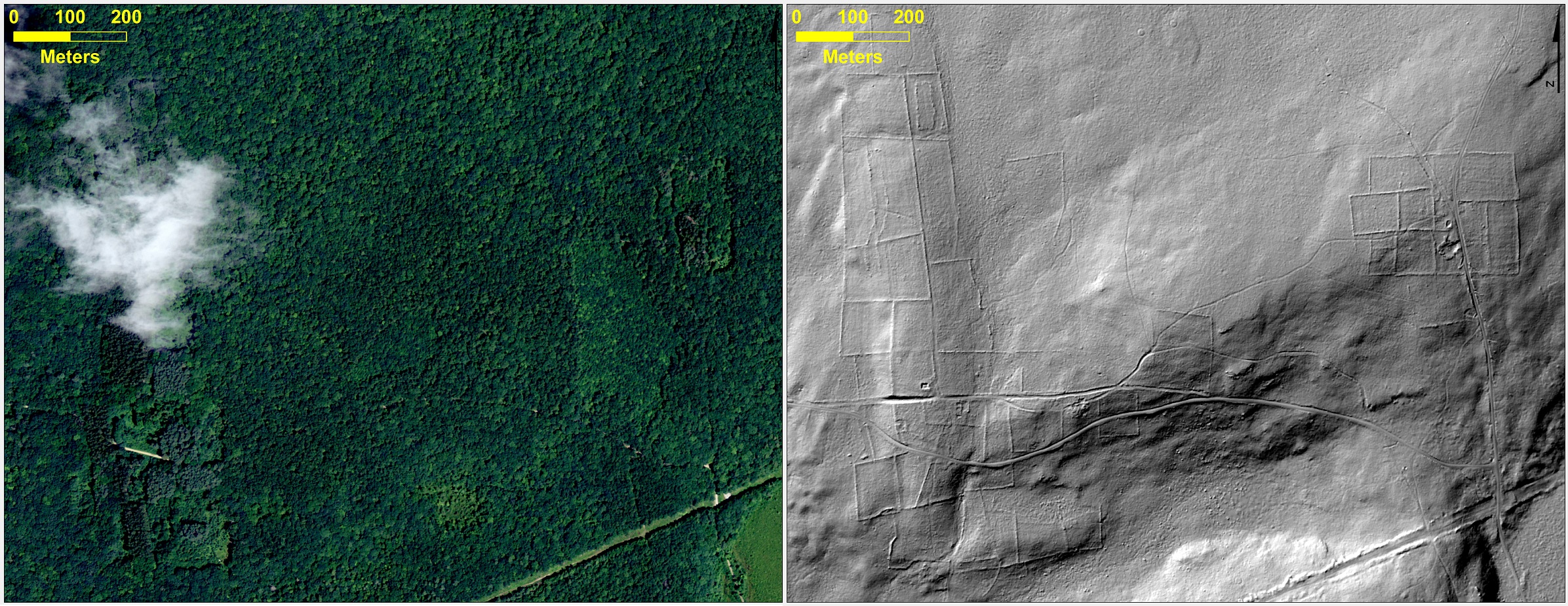
Aerial photograph of a forest in Connecticut (left), and bare-earth lidar image beneath the vegetation (right) showing archaeological remains. Credits: UofConn/Katharine Johnson
This sort of process has also been used by other archaeological teams to make major finds, like uncovering the lost “Ciudad Blanca” (aka. the “City of the Monkey God”) of Honduras. This ancient Mesoamerican settlement, which is believed to have been built between the 1st and 2nd millennium CE, had remained the stuff of legend for centuries. Despite multiple claims by explorers, no confirmed discovery was ever made.
But thanks to a joint effort by archaeologists from the University of Florida and the Houston-based National Center for Airborne Laser Mapping, an archaeological team was able to create images that stripped away the lush rainforest to revealed multiple structures – including pyramids, a plaza, a possible ball court, and many houses.
Lidar was also used by a research team from the University of Connecticut for the sake of studying the dynamics between human settlement and the historic landscape of New England. Using publicly available data, they were able to peer beneath all the current vegetation to detect the remnants of stone walls, building foundations, abandoned roads and what was once cleared farm land.
The revealing look at Beaver River is one of 50 stories that will be released on Dec. 5th, as part of a NASA Spinoff publication. Each year, Spinoff profiles about 50 NASA technologies that have transformed into commercial products and services, demonstrating the wider benefits of America’s investment in its space program. Spinoff is a publication of the Technology Transfer Program in NASA’s Space Technology Mission Directorate.
The International Space Station will be getting its very own laser at the end of 2014. And unlike the planet-smashing capabilities of the Death Star of Star Wars fame, this laser will to be enlisted for the purpose of science.
It’s called CATS, and no, it isn’t the latest attempt to put feline astronauts in space. CATS stands for the Cloud Aerosol Transport System. The goal of CATS is to study the distribution of tiny particles of dust and air contaminants known as aerosols.
Developed by research scientist Matt McGill at NASA’s Goddard Space Flight Center in Greenbelt Maryland, CATS is slated to head to the International Space Station later this year on September 12th aboard SpaceX’s CRS-5 flight of the Dragon spacecraft. CATS will be installed on the Japanese Experiment Module-Exposed Facility (JEM-EF) and will demonstrate the utility of state-of-the-art multi-wavelength laser technology to study aerosol distribution and transport in the atmosphere.
Such knowledge is critical in understanding the path and circulation of aerosols and pollutants worldwide. When the Eyjafjallajökull volcano erupted in Iceland back in 2010, many trans-Atlantic flights were grounded as a precaution. These measures are necessary as several flights have suffered engine failures in the past due to encounters with volcanic ash clouds, such as the four engine failure of KLM Fight 867 in 1989 and the British Airways Flight 9 incident over Southeast Asia in 1982. Knowing where these dangerous ash clouds are is crucial to the safety of air travel.
The expanding ash cloud spewing from Iceland’s Eyjafjallajökull volcano as seen from space in 2010. Credit: NASA.
To accomplish this, CATS will emit 5,000 1 milliJoule laser pulses a second at the 1064, 532 and 355 nanometer wavelengths. This represents a vast improvement in power requirements and thermal capabilities over a similar instrument currently in service aboard the Cloud-Aerosol Lidar and Infrared Pathfinder Satellite Observations (CALIPSO) Earth remote sensing spacecraft.
And it’s that third 355 nanometer wavelength that will make CATS stand out from CALIPSO. This will also allow researchers to differentiate between particle size and measure the horizontal and vertical distribution of aerosol particles in the atmosphere. CATS will also be capable of measuring the number of individual photons being reflected back at it, which will provide a much better resolution and understanding of current atmospheric activity.
“You get better data quality because you make fewer assumptions, and you get, presumably, a more accurate determination of what kind of particles you’re seeing in the atmosphere,” McGill said in a recent press release.
The International Space Station also provides a unique vantage point for CATS. In a highly inclined 51.7 degree orbit, the station passes over a good swath of the planet on 16 orbits daily on a westward moving ground track that repeats roughly every three days. This will assure CATS has coverage over a large percentage of the planet, including known pollutant transport routes across the northern Pacific and down from Canada over the U.S. Great Lakes region.
While the first two lasers will operate in the infrared and visual wavelengths, said third laser will work in the ultraviolet. And while this will give CATS an enhanced capability, engineers also worry that it may also be susceptible to contamination. “If you get contamination on any of your outgoing optics, they can self-destruct, and then your system is dead. You end up with a very limited instrument lifetime,” McGill said.
Still, if CATS is successful, it may pave the way for larger, free-flying versions that will monitor long-range atmospheric patterns and shifts in climate due to natural and man-made activity. And the ISS makes a good platform to test pathfinder missions like CATS at low cost. “In our current budget-constrained environment, we need to use what we already have, such as the [station], to do more with less,” McGill said.
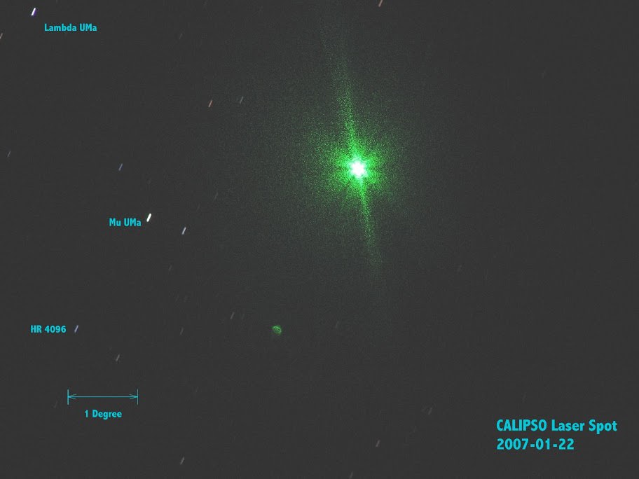
CALIPSO’s LiDAR imagedfrom the ground by Gregg Hendry in 2008. Used with permission.
The advent of a LiDAR system aboard the ISS has also generated a spirited discussion in the satellite tracking community concerning prospects for spotting CATS in operation from the ground. The CALIPSO LiDAR has been captured by ground spotters in the past. However, CALIPSO fires a much more powerful 110 milliJoule pulse at a rate of 20 times a second. Still, the lower power CATS system will be firing at a much faster rate, delivering a cumulative 5,000 milliJoules a second. CATS won’t be bright enough to show up on an illuminated pass of the ISS, but it just might be visible during darkened passes of the ISS through the Earth’s shadow. And, unlike CALLIPSO — which is part of the difficult to observe A-Train of Earth-observing satellites — the ISS passes in view of a majority of humanity. At very least, activity from CATS will be worth watching out for, and may well be seen either visually or photographically.
We’ll soon be adding CATS to the long list of outstanding science experiments being conducted aboard the International Space Station, and the sight of this “fully armed and operational battle station” may soon be coming to a dark sky site near you!