NASA: Reaches for New Heights – Greatest Hits Video

Video Caption: At NASA, we’ve been a little busy: landing on Mars, developing new human spacecraft, going to the space station, working with commercial partners, observing the Earth and the Sun, exploring our solar system and understanding our universe. And that’s not even everything.Credit: NASA

Check out this cool action packed video titled “NASA: Reaching for New Heights” – to see NASA’s ‘Greatest Hits’ from the past year

The 4 minute film is a compilation of NASA’s gamut of Robotic Science and Human Spaceflight achievements to explore and understand Planet Earth here at home and the heavens above- ranging from our Solar System and beyond to the Galaxy and the vast expanse of the Universe.

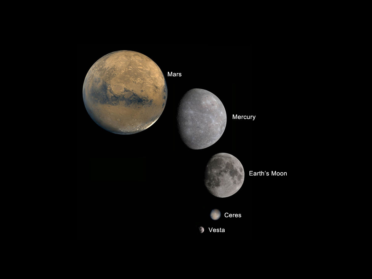
Image caption: Planets and Moons in perspective. Credit: NASA

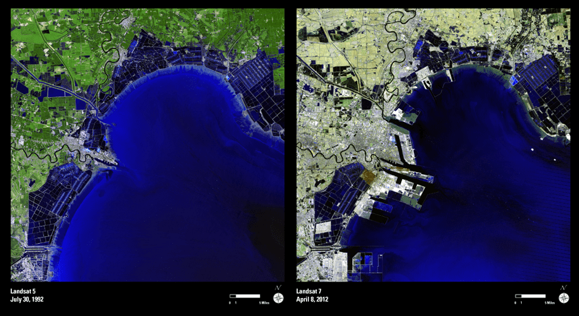
The missions and programs featured include inspiringly beautiful imagery from : Curiosity, Landsat, Aquarius, GRACE, NuSTAR, GRAIL, Dawn at Asteroid Vesta, SDO, X-48C Amelia, Orion, SLS, Apollo, SpaceX, Sierra Nevada Dream Chaser, Boeing CST-100, Commercial Crew, Hurricane Sandy from the ISS, Robonaut and more !

And even more space exploration thrills are coming in 2013 !

Ken Kremer

IMG_3760a_SpaceX launch 22 May 2012

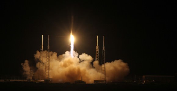
Image caption: SpaceX Falcon 9 rocket blasts off on May 22, 2012 with Dragon cargo capsule from Space Launch Complex-40 at Cape Canaveral Air Force Station, Fla., on the first commercial mission to the International Space Station. The next launch is set for March 1, 2013. Credit: Ken Kremer

The Top 5 “Earth as Art” Images, Thanks to Landsat

NASA’s first Earth-observing Landsat satellite launched from Vandenberg Air Force Base on July 23, 1972, and to celebrate the 40th anniversary of the program they asked the public to vote on their favorite images of the planet from the Landsat Earth as Art gallery. After over 14,000 votes, these were chosen as the top 5 favorites. Happy 40th anniversary, Landsat!

Landsat images from space are not merely pictures. They contain many layers of data collected at different points along the visible and invisible light spectrum. A single Landsat scene taken from 400 miles above Earth can accurately detail the condition of hundreds of thousands of acres of grassland, agricultural crops or forests.

“Landsat has given us a critical perspective on our planet over the long term and will continue to help us understand the big picture of Earth and its changes from space,” said NASA Administrator Charles Bolden. “With this view we are better prepared to take action on the ground and be better stewards of our home.”

In cooperation with the U.S. Geological Survey (USGS), a science agency of the Interior Department, NASA launched six of the seven Landsat satellites. The resulting archive of Earth observations forms a comprehensive record of human and natural land changes.

“The first 40 years of the Landsat program have delivered the most consistent and reliable record of Earth’s changing landscape.”

– Michael Freilich, director of NASA’s Earth Science Division

“Over four decades, data from the Landsat series of satellites have become a vital reference worldwide for advancing our understanding of the science of the land,” said Interior Department Secretary Ken Salazar. “The 40-year Landsat archive forms an indelible and objective register of America’s natural heritage and thus it has become part of this department’s legacy to the American people.”

The next satellite in the series, the Landsat Data Continuity Mission (LDCM) is scheduled to launch on February 11, 2013.

(Source: NASA/GSFC)

Find out more about the ongoing Landsat mission here, and see recent visualizations from Landsat on the USGS site here.

Video: NASA/GSFC. Inset image: Industrial growth in Binhai New Area, China.  Sub-feature: Erg Iguidi, an area of ever-shifting sand dunes extending from Algeria into Mauritania in northwestern Africa, one of the chosen top 5 Earth as Art images. NASA/GSFC/USGS.

Super Bowl Cities Seen From Space

Satellite image of RI and portions of southeastern Massachusetts. Credit: NASA/GSFC/Landsat 7

[/caption]

If you live in or are from the US, you probably know that today is Super Bowl Sunday. Whatever you happen to be doing, be it tailgating in Indianapolis, getting together with friends and family (and plenty of hot wings and nachos) in your living room or just waiting for all the fuss to be over, remember that, high above, NASA Earth-observing satellites are working hard doing what they do best: observing the Earth. Chances are they’ve imaged your home town many times.

Whichever team you’re rooting for, here’s a little bit of space science fun: the folks over at Goddard Space Flight Center in Greenbelt, MD, have shared some Landsat images of the home cities of this year’s big game.

The image above shows the central and northern RI and southeastern Massachusetts area, with Providence and Pawtucket seen as the densely-built central region and Foxborough, MA, where the Patriots’ home stadium is located, is just to the north of the image. This image was acquired by Landsat 7 in July 2002.

(Being of my home state, I admit I’m partial to that particular shot. I was down there somewhere!)

The NYC area seen from satellite. Credit: NASA/GSFC/Landsat 7

If you’re a die-hard Giants fan, you may recognize this area… you may even be in it! It’s a Landsat 7 image of the New York metro area acquired on August 8, 2002. Manhattan is in the center, most easily recognizable from space by the green rectangle of Central Park. New Jersey is on the left side, and Brooklyn on the center-right with Long Island stretching away to the east.

Indianapolis from Landsat 7 satellite. Credit: NASA/GSFC/Landsat 7

If you’re lucky enough to have tickets to the big game, you may be here: it’s a Landsat image of Indianapolis, IN acquired on July 11, 2001. The Colts may not have made it this year but right now the city is definitely “ready for some football!”

Of course, team and town loyalty aside, this gorgeous image from Expedition 30 crew members aboard the ISS shows everyone all in one place on the night of January 29, 2012 – with a nice touch of northern lights thrown in for good measure:

US East Coast on Jan. 29, 2012. (NASA)

Bright lights, big cities… but a small world, when you think about it. And remember, whichever team comes out on top today, tomorrow we’re all winners. (Until next season, of course!)

You can see these and more images from Goddard Space Flight Center on their Flickr album, and find out more about Landsat and how it benefits people around the world.

And you can follow Super Bowl XLVI news – and watch online – on the official NFL site here.

Get a $36 Million World Map for Free

When the first Landsat Earth-observing satellite launched in 1972, virtually every piece of technology that we think of as essential for viewing, sharing, or analyzing digital images — like the internet or DVD’s — either hadn’t been invented or commercialized, like the microprocessors that run desktop computers. “It cost about $4,000 for a single Landsat image, and it takes about 9,000 of them to map the land area of the globe,” said Jeff Masek, from NASA. “To make a global image for just one time period would have cost $36 million.” But now, in this age where everything is digital and it’s easy to exchange information, anyone can download Landsat images for free. Recently, NASA and the U.S. Geological Survey put the finishing touches on a new collection of mapped images covering the entire land surface of the Earth. However, if you want the entire full-size version, it would be as big as the Hoover Dam.

This collaboration between NASA, the U.S. Geological Survey, and the U.S. National Geospatial Agency, the Global Land Survey 2005 features around 9,500 images from NASA’s Landsat satellites captured between 2004–2007.

A Landsat image that could be artwork.

The images are detailed enough to make out features as small as 30 meters (about one-third the length of an American football field), they have been carefully screened for clouds, and each one shows the landscape during its growing season.

Some of the images are as striking as a piece of artwork. Stitched together into a single mosaic, the collection paints the most detailed picture of Earth’s land surface a person can get for free.

For more information see these two Landsat sites:

http://landsat.gsfc.nasa.gov/

http://www.landsat.org/

Source: NASA Earth Observatory