What’s Ahead for Rosetta – ‘Finding a Landing Strip’ on Bizarre Comet 67P/Churyumov-Gerasimenko

NAVCAM image taken by Rosetta on 5 August 2014 from a distance of about 145 km from comet 67P/Churyumov-Gerasimenko. Image has been rotated 180 degrees. Credit: ESA/Rosetta/NAVCAM

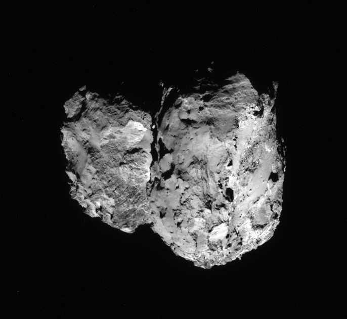
Where would you land here?
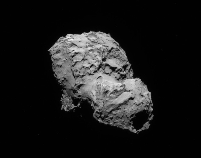
Newly released NAVCAM image taken by Rosetta on 5 August 2014 from a distance of about 145 km from comet 67P/Churyumov-Gerasimenko. Image has been rotated 180 degrees. Credit: ESA/Rosetta/NAVCAM[/caption]

Following the flawless and history making arrival of the European Space Agency’s (ESA) Rosetta spacecraft at its long sought destination of Comet 67P/Churyumov-Gerasimenko on Wednesday, Aug. 6, the goal of conducting ground breaking science at this utterly alien and bizarre icy wanderer that looks like a ‘Scientific Disneyland’ can actually begin.

Rosetta is the first spacecraft in history to rendezvous with a comet and enter orbit – after a more than 10 year chase of 6.4 billion kilometers (4 Billion miles) along a highly complex trajectory from Earth. The arrival event was broadcast live from mission control at ESA’s spacecraft operations centre (ESOC) in Darmstadt, Germany. Read my complete arrival story – here.

So what’s ahead for Rosetta? Another audacious and history making event – Landing on the comet!

A top priority task is also another highly complex task – ‘Finding a landing strip’ on the bizarre world of Comet 67P for the piggybacked Philae comet lander equipped with 10 science instruments.

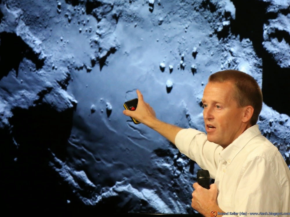
“The challenge ahead is to map the surface and find a landing strip,” said Andrea Accomazzo, ESA Rosetta Spacecraft Operations Manager, at the Aug. 6 ESA webcast.

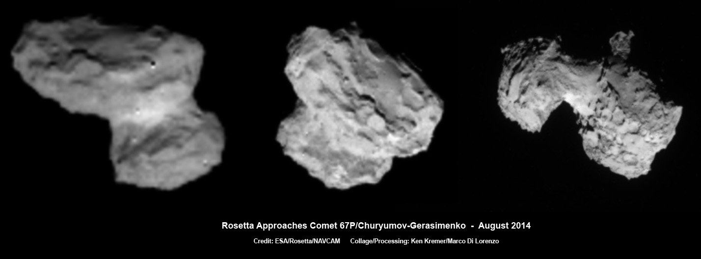
That will be no easy task based on the spectacular imagery captured by the OSIRIS high resolution science camera and the Navcam camera that has revealed an utterly wacky and incredibly differentiated world like none other we have ever visited or expected when the mission was conceived.

Magnificently detailed new navcam images were released by ESA today, Aug, 7, streaming back to Earth across some 405 million kilometers (250 million miles) of interplanetary space – see above and below.

The team will have its hand full trying to find a safe spot for touchdown.

“We now see lots of structure and details. Lots of topography is visible on the surface,” said Holger Sierks, principal investigator for Rosetta’s OSIRIS camera from the Max Planck Institute for Solar System Research in Gottingen, Germany, during the webcast.

“There is a big depression and 150 meter high cliffs, rubble piles, and also we see smooth areas and plains. It’s really fantastic”

“We see a village of house size boulders. Some about 10 meters in size and bigger and they vary in brightness. And some with sharp edges. We don’t know their composition yet,” explained Sierks.

NAVCAM image taken on 6 August 2014 from a distance of about 96 km from comet 67P/Churyumov-Gerasimenko.   Credit: ESA/Rosetta/NAVCAM
Newly released NAVCAM image taken on 6 August 2014 from a distance of about 96 km from comet 67P/Churyumov-Gerasimenko. Credit: ESA/Rosetta/NAVCAM

The key to finding a safe landing site for Philae will be quickly conducting a global comet mapping campaign with OSIRIS, Navcam and the remaining suite of 11 science instruments to provide a detailed scientific study of the physical characteristics and chemical composition of the surface.

They also need to determine which areas are hard or soft.

Holger Sierks, OSIRIS principal investigator, discuss spectacular hi res comet images returned so far by Rosetta during the Aug. 6 ESA webcast from mission control at ESOC, Darmstadt, Germany. Credit: Roland Keller
Holger Sierks, OSIRIS principal investigator, discusses spectacular hi res comet images returned so far by Rosetta during the Aug. 6 ESA webcast from mission control at ESOC, Darmstadt, Germany. Credit: Roland Keller

“Our first clear views of the comet have given us plenty to think about,” says Matt Taylor, ESA’s Rosetta project scientist.

“Is this double-lobed structure built from two separate comets that came together in the Solar System’s history, or is it one comet that has eroded dramatically and asymmetrically over time? Rosetta, by design, is in the best place to study one of these unique objects.”

The image of Comet 67P/Churyumov-Gerasimenko was taken by Rosetta’s OSIRIS narrow-angle camera on 3 August 2014 from a distance of 285 km.   Credits: ESA/Rosetta/MPS for OSIRIS Team MPS/UPD/LAM/IAA/SSO/INTA/UPM/DASP/IDA
The image of Comet 67P/Churyumov-Gerasimenko was taken by Rosetta’s OSIRIS narrow-angle camera on 3 August 2014 from a distance of 285 km. Credits: ESA/Rosetta/MPS for OSIRIS Team MPS/UPD/LAM/IAA/SSO/INTA/UPM/DASP/IDA

Yesterday’s (Aug. 6) critical final thruster firing placed the 1.3 Billion euro robotic emissary from Earth into a triangular shaped orbit about 100 kilometers (62 miles) above and in front of the comet’s incredibly varied surface.

Therefore the initial mapping will be conducted from the 100 km (62 mi.) standoff distance.

Since the landing is currently targeted for November 11, 2014, in barely three months time there is not a moment to waste.

“Over the next few months, in addition to characterizing the comet nucleus and setting the bar for the rest of the mission, we will begin final preparations for another space history first: landing on a comet,” says Taylor.

The team will identify up to five possible landing sites by late August and expect to choose the primary site by mid-September.

Then the team has to plan and build the programming and maneuvers for the final timeline to implement the sequence of events leading to the nailbiting landing.

With Rosetta now travelling in a series of 100 kilometer-long (62 mile-long) triangular arcs in front of the comet lasting about 3 days each, it will also be firing thrusters at each apex.

After catching up with the comet Rosetta will slightly overtake and enter orbit from the ‘front’ of the comet as both the spacecraft and 67P/CG move along their orbits around the Sun. Rosetta will carry out a complex series of manoeuvres to reduce the separation between the spacecraft and comet from around 100 km to 25-30 km. From this close orbit, detailed mapping will allow scientists to determine the landing site for the mission’s Philae lander. Immediately prior to the deployment of Philae in November, Rosetta will come to within just 2.5 km of the comet’s nucleus.  This animation is not to scale; Rosetta’s solar arrays span 32 m, and the comet is approximately 4 km wide.  Credit: ESA–C. Carreau
After catching up with the comet Rosetta will slightly overtake and enter orbit from the ‘front’ of the comet as both the spacecraft and 67P/CG move along their orbits around the Sun. Rosetta will carry out a complex series of manoeuvres to reduce the separation between the spacecraft and comet from around 100 km to 25-30 km. From this close orbit, detailed mapping will allow scientists to determine the landing site for the mission’s Philae lander. Immediately prior to the deployment of Philae in November, Rosetta will come to within just 2.5 km of the comet’s nucleus. This animation is not to scale; Rosetta’s solar arrays span 32 m, and the comet is approximately 4 km wide. Credit: ESA–C. Carreau

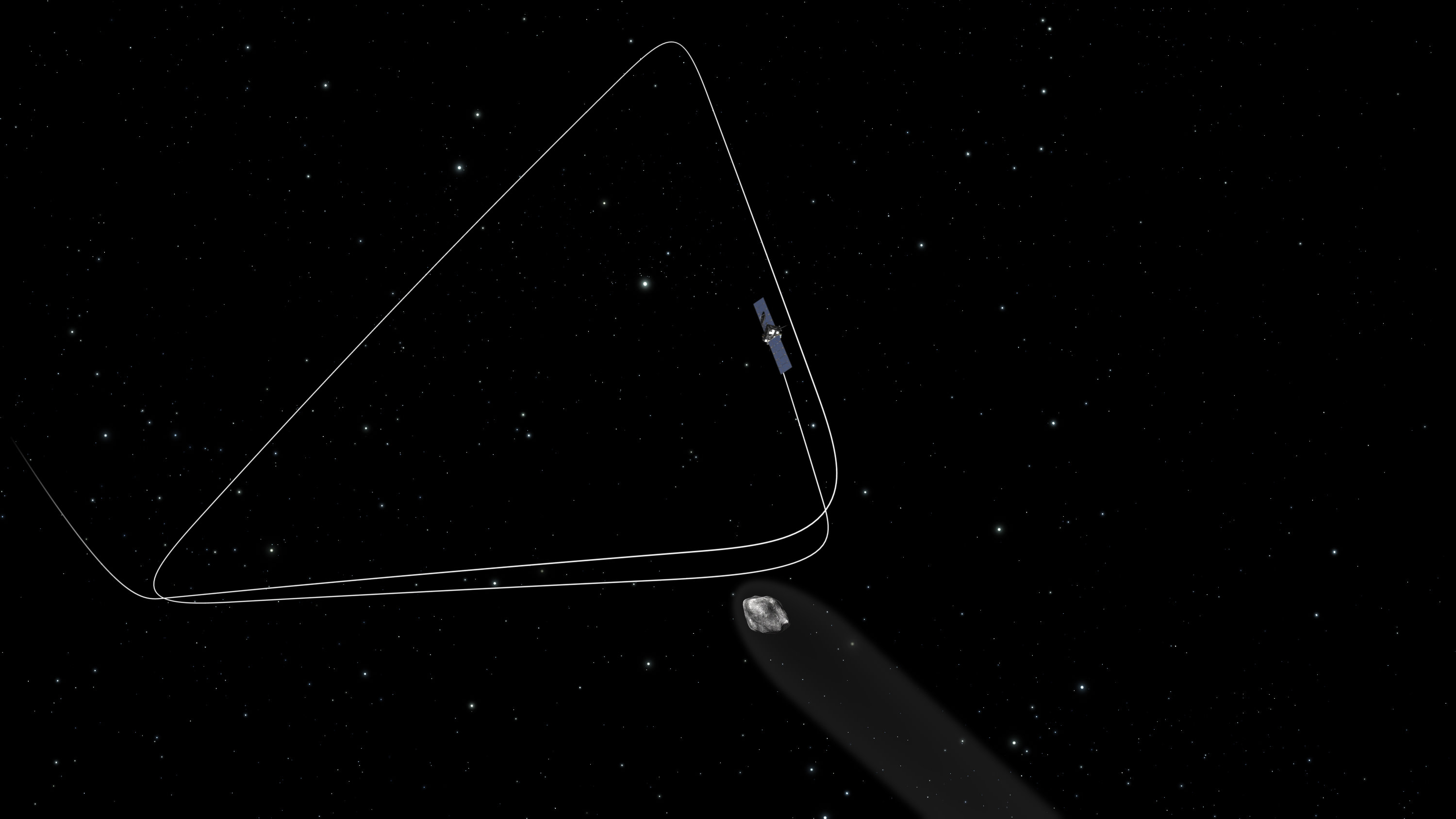
But it will also gradually edge closer over the next six weeks to about 50 km distance and then even closer to lower Rosetta’s altitude about Comet 67P until the spacecraft is captured by the comet’s gravity.

In November 2014, Rosetta will attempt another historic first when it deploys the Philae science lander from an altitude of just about 2.5 kilometers above the comet for the first ever attempt to land on a comet’s nucleus.

The three-legged lander will fire harpoons and use ice screws to anchor itself to the 4 kilometer (2.5 mile) wide comet’s surface. Philae will collect stereo and panoramic images and also drill into and sample its incredibly varied surface.

How will Philae land?

Stefan Ulamec, Philae Lander Manager from the German Aerospace Center (DLR) talked about the challenges of landing in a low gravity environment during the ESA webcast.

“The touchdown will be at a speed of just 1 m/s,” Ulamec explained. “This is like walking and bouncing against a wall.”

Details in an upcoming story!

Why study comets?

Comets are leftover remnants from the formation of the solar system. Scientists believe they delivered a vast quantity of water to Earth. They may have also seeded Earth with organic molecules.

ESA’s Rosetta spacecraft on final approach to Comet 67P/Churyumov-Gerasimenko in early August 2014. This collage of navcam imagery from Rosetta was taken on Aug. 1, 2, 3 and 4 from distances of 1026 km, 500 km, 300 km and 234 km. Not to scale.  Credit: ESA/Rosetta/NAVCAM - Collage/Processing: Marco Di Lorenzo/Ken Kremer- kenkremer.com
ESA’s Rosetta spacecraft on final approach to Comet 67P/Churyumov-Gerasimenko in early August 2014. This collage of navcam imagery from Rosetta was taken on Aug. 1, 2, 3 and 4 from distances of 1026 km, 500 km, 300 km and 234 km. Not to scale. Credit: ESA/Rosetta/NAVCAM – Collage/Processing: Marco Di Lorenzo/Ken Kremer- kenkremer.com

Stay tuned here for Ken’s continuing Rosetta, Curiosity, Opportunity, Orion, SpaceX, Boeing, Orbital Sciences, commercial space, MAVEN, MOM, Mars and more Earth and Planetary science and human spaceflight news.

Ken Kremer

…….

Read my Rosetta series here:

Rosetta Arrives at ‘Scientific Disneyland’ for Ambitious Study of Comet 67P/Churyumov-Gerasimenko after 10 Year Voyage

Rosetta on Final Approach to Historic Comet Rendezvous – Watch Live Here

Rosetta Probe Swoops Closer to Comet Destination than ISS is to Earth and Reveals Exquisite Views

Rosetta Orbiter less than 500 Kilometers from Comet 67P Following Penultimate Trajectory Burn

Rosetta Closing in on Comet 67P/Churyumov-Gerasimenko after Decade Long Chase
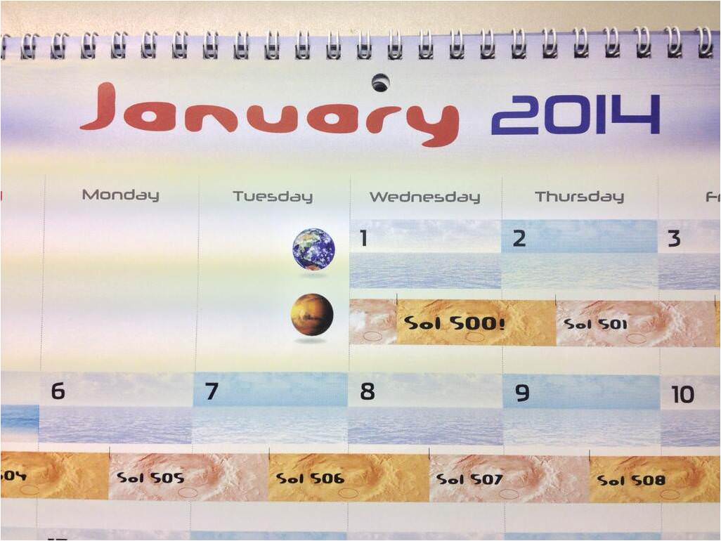
ESA’s Rosetta Spacecraft nears final approach to Comet 67P/Churyumov-Gerasimenko in late July 2014. This collage of imagery from Rosetta combines Navcam camera images at right taken nearing final approach from July 25 (3000 km distant) to July 31, 2014 (1327 km distant), with OSIRIS wide angle camera image at left of comet’s expanding coma cloud on July 25. Images to scale and contrast enhanced to show further detail. Credit: ESA/Rosetta/NAVCAM/OSIRIS/MPS/UPD/LAM/IAA/SSO/INTA/UPM/DASP/IDA   Collage/Processing: Marco Di Lorenzo/Ken Kremer
ESA’s Rosetta Spacecraft nears final approach to Comet 67P/Churyumov-Gerasimenko in late July 2014. This collage of imagery from Rosetta combines Navcam camera images at right taken nearing final approach from July 25 (3000 km distant) to July 31, 2014 (1327 km distant), with OSIRIS wide angle camera image at left of comet’s expanding coma cloud on July 25. Images to scale and contrast enhanced to show further detail. Credit: ESA/Rosetta/NAVCAM/OSIRIS/MPS/UPD/LAM/IAA/SSO/INTA/UPM/DASP/IDA Collage/Processing: Marco Di Lorenzo/Ken Kremer

Rosetta on Final Approach to Historic Comet Rendezvous – Watch Live Here

ESA’s Rosetta spacecraft on final approach to Comet 67P/Churyumov-Gerasimenko in early August 2014. This collage of navcam imagery from Rosetta was taken on Aug. 1, 2, 3 and 4 from distances of 1026 km, 500 km, 300 km and 234 km. Not to scale. Credit: ESA/Rosetta/NAVCAM - Collage/Processing: Marco Di Lorenzo/Ken Kremer- kenkremer.com

ESA’s Rosetta spacecraft on final approach to Comet 67P/Churyumov-Gerasimenko in early August 2014. This collage of navcam imagery from Rosetta was taken on Aug. 1, 2, 3 and 4 from distances of 1026 km, 500 km, 300 km and 234 km. Not to scale. Credit: ESA/Rosetta/NAVCAM – Collage/Processing: Marco Di Lorenzo/Ken Kremer- kenkremer.com
Watch ESA’s Live Webcast here on Aug. 6 starting at 4 AM EDT/ 8 AM GMT[/caption]

After a decade long chase of 6.4 billion kilometers (4 Billion miles) through interplanetary space the European Space Agency’s (ESA) Rosetta spacecraft is now on final approach for its historic rendezvous with its target comet 67P scheduled for Wednesday morning, Aug. 6. some half a billion kilometers from the Sun. See online webcast below.

Rosetta arrives at Comet 67P/Churyumov-Gerasimenko in less than 12 hours and is currently less than 200 kilometers away.

You can watch a live streaming webcast of Rosetta’s Aug. 6 orbital arrival here, starting at 10:00 a.m. CEST/8 a.m. GMT/4 a.m. EDT/1 a.m. PDT via a transmission from ESA’s spacecraft operations centre in Darmstadt, Germany.

Rosetta is the first mission in history to rendezvous with a comet and enter orbit around it. The probe will then escort comet 67P as it loops around the Sun, as well as deploy the piggybacked Philae lander to its uneven surface.

Orbit entry takes place after the probe initiates the last of 10 orbit correction maneuvers (OCM’s) on Aug. 6 starting at 11:00 CEST/09:00 GMT.

The thruster firing, dubbed the Close Approach Trajectory – Insertion (CATI) burn, is scheduled to last about 6 minutes 26 seconds. Engineers transmitted the commands last night, Aug. 4.

CATI will place the 1.3 Billion Euro Rosetta into an initial orbit at a distance of about 100 kilometers (62 miles).

Since the one way signal time is 22 min 29 sec, it will take that long before engineers can confirm the success of the CATI thruster firing.

As engineers at ESOC mission control carefully navigate Rosetta ever closer, the probe has been capturing spectacular imagery showing rocks, gravel and tiny crater like features on its craggily surface with alternating smooth and rough terrain and deposits of water ice.

See above and below our collages (created by Marco Di Lorenzo & Ken Kremer) of navcam camera approach images of the comet’s two lobed nucleus captured over the past week and a half. Another shows an OSIRIS camera image of the expanding coma cloud of water and dust.

ESA’s Rosetta Spacecraft nears final approach to Comet 67P/Churyumov-Gerasimenko in late July 2014. This collage of imagery from Rosetta combines Navcam camera images at right taken nearing final approach from July 25 (3000 km distant) to July 31, 2014 (1327 km distant), with OSIRIS wide angle camera image at left of comet’s expanding coma cloud on July 25. Images to scale and contrast enhanced to show further detail. Credit: ESA/Rosetta/NAVCAM/OSIRIS/MPS/UPD/LAM/IAA/SSO/INTA/UPM/DASP/IDA   Collage/Processing: Marco Di Lorenzo/Ken Kremer
ESA’s Rosetta Spacecraft nears final approach to Comet 67P/Churyumov-Gerasimenko in late July 2014. This collage of imagery from Rosetta combines Navcam camera images at right taken nearing final approach from July 25 (3000 km distant) to July 31, 2014 (1327 km distant), with OSIRIS wide angle camera image at left of comet’s expanding coma cloud on July 25. Images to scale and contrast enhanced to show further detail. Credit: ESA/Rosetta/NAVCAM/OSIRIS/MPS/UPD/LAM/IAA/SSO/INTA/UPM/DASP/IDA Collage/Processing: Marco Di Lorenzo/Ken Kremer

The up close imagery revealed that the mysterious comet looks like a ‘rubber ducky’ and is comprised of two lobes merged at a bright band at the narrow neck in between.

Rosetta’s navcam camera has been commanded to capture daily images of the comet that rotates around once every 12.4 hours.

After orbital insertion on Aug. 6, Rosetta will initially be travelling in a series of 100 kilometer-long (62 mile-long) triangular arcs in front of the comet while firing thrusters at each apex. Further engine firings will gradually lower Rosetta’s altitude about Comet 67P until the spacecraft is captured by the comet’s gravity.

ESA’s Rosetta Spacecraft on final approach to Comet 67P/Churyumov-Gerasimenko in early August 2014. This collage of navcam imagery from Rosetta was taken on Aug. 1, 2 and 3 from distances of 1026 km, 500 km and 300 km. Not to scale.  Credit: ESA/Rosetta/NAVCAM   Collage/Processing: Ken Kremer/Marco Di Lorenzo
ESA’s Rosetta Spacecraft on final approach to Comet 67P/Churyumov-Gerasimenko in early August 2014. This collage of navcam imagery from Rosetta was taken on Aug. 1, 2 and 3 from distances of 1026 km, 500 km and 300 km. Not to scale. Credit: ESA/Rosetta/NAVCAM Collage/Processing: Ken Kremer/Marco Di Lorenzo

Rosetta will continue in orbit at comet 67P for a 17 month long study.

In November 2014, Rosetta will attempt another historic first when it deploys the piggybacked Philae science lander from an altitude of just about 2.5 kilometers above the comet for the first ever attempt to land on a comet’s nucleus. The lander will fire harpoons to anchor itself to the 4 kilometer (2.5 mile) wide comet’s surface.

Together, Rosetta and Philae will investigate how the pristine frozen comet composed of ice and rock is transformed by the warmth of the Sun. They will also search for organic molecules, nucleic acids and amino acids, the building blocks for life as we know it.

Rosetta was launched on 2 March 2004 on an Ariane 5 G+ rocket from Europe’s spaceport in Kourou, French Guiana.

Stay tuned here for Ken’s continuing Rosetta, Curiosity, Opportunity, Orion, SpaceX, Boeing, Orbital Sciences, commercial space, MAVEN, MOM, Mars and more Earth and Planetary science and human spaceflight news.

Ken Kremer

Ranger 7 Takes 1st Image of the Moon by a US Spacecraft 50 Years Ago – July 31, 1964

Ranger 7 took this image, the first picture of the Moon by a U.S. spacecraft, on 31 July 1964 at 13:09 UT (9:09 AM EDT) about 17 minutes before impacting the lunar surface. Credit: NASA/JPL-Caltech

As we remember the 45th anniversary of Earth’s historic 1st manned lunar landing last week by America’s Apollo 11 crew of Neil Armstrong and Buzz Aldrin on July 20, 1969, it’s likewise well worth recalling NASA’s pioneering and historic unmanned robotic mission Ranger 7 – that led the way to the Moon almost exactly 5 years earlier and that paved the path for the eventual 1st human footsteps on another celestial body.

Indeed the first critical robotic step to the manned landings was successfully taken when NASA’s unmanned Ranger 7 probe captured the first image of the Moon by a U.S. spacecraft 50 Years ago on July 31, 1964.

Ranger 7 took the milestone maiden picture of the Moon by an American spacecraft, on 31 July 1964, shown above, at 13:09 GMT (9:09 AM EDT) about 17 minutes before impacting the lunar surface on a suicide dive.

The history making image was taken at an altitude of 2110 kilometers and is centered at 13 S, 10 W and covers about 360 kilometers from top to bottom. The large Alphonsus crater is at center right and 108 km in diameter. Ptolemaeus crater is above and Arzachel is below.

Ranger 7 impacted out of view of the lead image, off to the left of the upper left corner.

“It looks as though this particular shot has been indeed a textbook operation,” William H. Pickering, the director of JPL during the mission, said at the time.

Guericke Crater as seen by Ranger 7. Ranger 7 B-camera image of Guericke crater (11.5 S, 14.1 W, diameter 63 km) taken from a distance of 1335 km. The dark flat floor of Mare Nubium dominates most of the image, which was taken 8.5 minutes before Ranger 7 impacted the Moon on 31 July 1964. The frame is about 230 km across and north is at 12:30. The impact site is off the frame to the left. Credit:  NASA/JPL-Caltech
Guericke Crater as seen by Ranger 7
Ranger 7 B-camera image of Guericke crater (11.5 S, 14.1 W, diameter 63 km) taken from a distance of 1335 km. The dark flat floor of Mare Nubium dominates most of the image, which was taken 8.5 minutes before Ranger 7 impacted the Moon on 31 July 1964. The frame is about 230 km across and north is at 12:30. The impact site is off the frame to the left. Credit: NASA/JPL-Caltech

The purpose of NASA’s robotic Ranger program was to take high-quality pictures of the Moon and transmit them back to Earth in real time before being decimated on impact.

NASA Ranger 7 spacecraft. Credit:  NASA/JPL-Caltech
NASA Ranger 7 spacecraft. Credit: NASA/JPL-Caltech

The priceless pictures would be used for science investigations as well as to search for suitable landing sites for NASA’s then planned Apollo manned Moon landers.

It’s hard to conceive now, but 5 decades ago at the dawn of the Space Age no one knew what the surface of the Moon was really like. There were vigorous debates back then on whether it was even hard or soft. Was it firm? Would a landed spacecraft or human astronaut sink?

Last Ranger 7 images taken before impact on the Moon.  They were taken by the number 1 and 3 P-channel cameras at 0.39 and 0.19 s before impact from an altitude of 1070 and 519 meters, respectively. The pictures are cut off because the spacecraft impacted the surface before completing the transmission. The top image was taken by the P3 camera and the bottom image by P1. The P3 image is about 25 m across. North is at 12:30 for both images. The impact occurred on 31 July 1964 at 13:25:48.82 UT. Credit: Credit:  NASA/JPL-Caltech
Last Ranger 7 images taken before impact on the Moon. They were taken by the number 1 and 3 P-channel cameras at 0.39 and 0.19 s before impact from an altitude of 1070 and 519 meters, respectively. The pictures are cut off because the spacecraft impacted the surface before completing the transmission. The top image was taken by the P3 camera and the bottom image by P1. The P3 image is about 25 m across. North is at 12:30 for both images. The impact occurred on 31 July 1964 at 13:25:48.82 UT. Credit: NASA/JPL-Caltech

Altogether the probe took 4,308 excellent quality pictures during its final 17 minutes before crashing into the Moon at 13:26 GMT (9:26 p.m. EDT) in an area between Mare Nubium and Oceanus Procellarum at a spot subsequently named Mare Cognitum at 10.63 S latitude, 20.60 W longitude.

The final image from Ranger 7 shown herein had a resolution of 0.5 meter/pixel.

Ranger 7 was launched atop an Atlas Agena B rocket on 28 July 1964 from what was then known as Cape Kennedy and smashed into our nearest neighbor after 68.6 hours of flight at a velocity of 2.62 km/s (1.62 miles per second).

The 365.7 kilogram (806 lb) vehicle was 4.5 m wide and stood 3.6 m (11 ft) tall and was the Block 3 version of the Ranger spacecraft. It was powered by a pair of 1.5 m long solar panels and was equipped with a science payload of six television vidicon cameras transmitting data via the pointable high gain antennae mounted at the base.

Ranger 7 was the first successful mission in the Ranger series. The flight was entirely successful and was followed by Ranger’s 8 and 9. They were built by NASA’s Jet Propulsion Laboratory, Pasadena, California.

Here’s a short 1964 documentary chronicling Ranger 7 titled “Lunar Bridgehead” that truly harkens back to the 1950s and 1960s and sci fi movies of the time. No wonder since that’s when it was produced.

Video Caption. This 1964 documentary titled “Lunar Bridgehead produced by NASA’s Jet Propulsion Laboratory, Pasadena, California, chronicles the moments leading up to and following the Ranger 7 mission’s lunar impact 50 years ago. Credit: NASA/JPL-Caltech

During the 1960’s NASA implemented an ambitions three pronged strategy of robotic missions – including Ranger, Lunar Orbiter and Surveyor – that imaged the Moon and studied it’s physical and chemical properties and supported and enabled the Apollo program and led directly to Neil Armstrong stepping onto the alien lunar landscape.

Three members of the Ranger 7 television experiment team stand near a scale model and lunar globe at NASA’s Jet Propulsion Laboratory (JPL). From left: Ewen Whitaker, Dr. Gerard Kuiper, and Ray Heacock. Kuiper was the director of the Lunar and Planetary Laboratory (LPL) at the University of Arizona. Whitaker was a research associate at LPL. Heacock was the Lunar and Planetary Instruments section chief at JPL.  Credit:  NASA/JPL-Caltech
Three members of the Ranger 7 television experiment team stand near a scale model and lunar globe at NASA’s Jet Propulsion Laboratory (JPL). From left: Ewen Whitaker, Dr. Gerard Kuiper, and Ray Heacock. Kuiper was the director of the Lunar and Planetary Laboratory (LPL) at the University of Arizona. Whitaker was a research associate at LPL. Heacock was the Lunar and Planetary Instruments section chief at JPL. Credit: NASA/JPL-Caltech

Read more about pathfinding space missions in my earlier space history story about Mariner 10 – the first space probe to ever carry out a planetary gravity assist maneuver used to alter its speed and trajectory – in order to reach another celestial body – here.

Read my 45th Apollo 11 anniversary articles here:

Apollo 11 Splashdown 45 Years Ago on July 24, 1969 Concludes 1st Moon Landing Mission – Gallery

Historic Human Spaceflight Facility at Kennedy Renamed in Honor of Neil Armstrong – 1st Man on the Moon

Apollo 11 Moon Landing 45 Years Ago on July 20, 1969: Relive the Moment! – With an Image Gallery and Watch the Restored EVA Here

Book Review: Neil Armstrong – A Life of Flight by Jay Barbree

Stay tuned here for Ken’s Earth & Planetary science and human spaceflight news.

Ken Kremer

Liftoff of Ranger 7 on July 28, 1964 from Cape Kennedy at Launch Complex 12.  Credit: NASA
Liftoff of Ranger 7 on July 28, 1964 from Cape Kennedy at Launch Complex 12. Credit: NASA
Neil Armstrong and Buzz Aldrin plant the US flag on the Lunar Surface during 1st human moonwalk in history 45 years ago on July 20, 1969 during Apollo 1l mission. Credit: NASA
Neil Armstrong and Buzz Aldrin plant the US flag on the Lunar Surface during 1st human moonwalk in history 45 years ago on July 20, 1969 during Apollo 11 mission. Credit: NASA

Curiosity Marks Milestone Anniversary – 1 Martian Year On Mars!

NASA's Mars Curiosity Rover captures a selfie to mark a full Martian year -- 687 Earth days -- spent exploring the Red Planet. Curiosity Self-Portrait was taken at the 'Windjana' Drilling Site in April and May 2014 using the Mars Hand Lens Imager (MAHLI) camera at the end of the roboic arm. Credit: NASA/JPL-Caltech/MSSS

NASA’s Curiosity rover celebrated a milestone anniversary today, June 24 – 1 Martian Year on Mars!

A Martian year is equivalent to 687 Earth days, or nearly two Earth years.

NASA marked the illustrious achievement with the release of a new ‘selfie’ captured recently while drilling deep into the Red Planet to unlock the secrets of Mars hidden past eons ago when the planet was far warmer and wetter and more conducive to the origin of life.

Curiosity’s new self-portrait was taken at the ‘Windjana’ Drilling Site in April and May 2014 using the Mars Hand Lens Imager (MAHLI) camera at the end of the robotic arm.

As of today the 1 ton rover has been exploring the alien surface for a full Martian year since her nail biting touchdown inside Gale Crater on Aug. 5, 2012 – using the unprecedented sky crane maneuver which culminated in a rocket assisted touchdown astride a humongous mountain named Mount Sharp.

Mount Sharp dominates the center of Gale Crater and reaches 3.4 miles (5.5 km) into the Martian sky – taller than Mount Rainier.

During Mars Year 1 on Mars, Earth’s metallic emissary has already accomplished her primary objective of discovering a habitable zone on the Red Planet that contains the chemical ingredients necessary to support microbial life in the ancient past.

Curiosity rover panorama of Mount Sharp captured on June 6, 2014 (Sol 651) during traverse inside Gale Crater.  Note rover wheel tracks at left.  She will eventually ascend the mountain at the ‘Murray Buttes’ at right later this year. Assembled from Mastcam color camera raw images and stitched by Marco Di Lorenzo and Ken Kremer.   Credit:   NASA/JPL/MSSS/Marco Di Lorenzo/Ken Kremer-kenkremer.com
Curiosity rover panorama of Mount Sharp captured on June 6, 2014 (Sol 651) during traverse inside Gale Crater. Note rover wheel tracks at left. She will eventually ascend the mountain at the ‘Murray Buttes’ at right later this year. Assembled from Mastcam color camera raw images and stitched by Marco Di Lorenzo and Ken Kremer. Credit: NASA/JPL/MSSS/Marco Di Lorenzo/Ken Kremer-kenkremer.com

During 2013, Curiosity conducted the first two drill campaigns at the ‘John Klein’ and ‘Cumberland’ outcrop targets inside Yellowknife Bay. They were both mudstone rock outcrops and the interiors were markedly different in color and much lighter compared to the new drill site at ‘Windjana’ into a slab of red, sandstone rock.

The fresh bore hole was drilled into the “Windjana” rock outcrop on May 5, 2014, Sol 621, at the base of Mount Remarkable at a science stopping point called “The Kimberley Waypoint.”

It was 0.63 inch (1.6 centimeters) in diameter and about 2.6 inches (6.5 centimeters) deep and resulted in a mound of dark grey colored drill tailings piled around.

NASA’s Curiosity rover trundles towards Mount Sharp (right) across the alien terrain of Mars - our Solar Systems most Earth-like planet - and leaves behind dramatic wheel tracks in her wake, with Gale crater rim visible in the distance at left. Curiosity captured this photo mosaic of her wheel tracks, mountain and crater rim on Sol 644 after departing ‘Kimberley’ drill site in mid-May 2014. Navcam raw images were stitched and colorized and contrast enhanced to bring out detail. Credit: NASA/JPL-Caltech/Marco Di Lorenzo/Ken Kremer – kenkremer.com
NASA’s Curiosity rover trundles towards Mount Sharp (right) across the alien terrain of Mars – our Solar Systems most Earth-like planet – and leaves behind dramatic wheel tracks in her wake, with Gale crater rim visible in the distance at left. Curiosity captured this photo mosaic of her wheel tracks, mountain and crater rim on Sol 644 after departing ‘Kimberley’ drill site in mid-May 2014. Navcam raw images were stitched and colorized and contrast enhanced to bring out detail. Credit: NASA/JPL-Caltech/Marco Di Lorenzo/Ken Kremer – kenkremer.com

Windjana lies some 2.5 miles (4 kilometers) southwest of Yellowknife Bay.

Curiosity has successfully delivered pulverized and sieved samples from all three drill sites to the pair of onboard miniaturized chemistry labs; the Chemistry and Mineralogy instrument (CheMin) and the Sample Analysis at Mars instrument (SAM) – for chemical and compositional analysis.

Composite photo mosaic shows deployment of NASA Curiosity rovers robotic arm and two holes after drilling into ‘Windjana’ sandstone rock on May 5, 2014, Sol 621, at Mount Remarkable as missions third drill target for sample analysis by rover’s chemistry labs.  The navcam raw images were stitched together from several Martian days up to Sol 621, May 5, 2014 and colorized.   Credit: NASA/JPL-Caltech/Ken Kremer - kenkremer.com/Marco Di Lorenzo
Composite photo mosaic shows deployment of NASA Curiosity rovers robotic arm and two holes after drilling into ‘Windjana’ sandstone rock on May 5, 2014, Sol 621, at Mount Remarkable as missions third drill target for sample analysis by rover’s chemistry labs. The navcam raw images were stitched together from several Martian days up to Sol 621, May 5, 2014 and colorized. Credit: NASA/JPL-Caltech/Ken Kremer – kenkremer.com/Marco Di Lorenzo

It was through the results of the SAM and CheMin analysis and the discovery of clay minerals that the science team was able to determine that this area on the floor of Gale Crater is a habitable zone.

“Windjana has more magnetite than previous samples we’ve analyzed,” said David Blake, principal investigator for Curiosity’s Chemistry and Mineralogy (CheMin) instrument at NASA’s Ames Research Center, Moffett Field, California, in a statement.

“A key question is whether this magnetite is a component of the original basalt or resulted from later processes, such as would happen in water-soaked basaltic sediments. The answer is important to our understanding of habitability and the nature of the early-Mars environment.”

Chemical analysis and further sample deliveries are in progress as NASA’s rover is ‘on the go’ to simultaneously maximize movement and research activities.

Curiosity’s Panoramic view of Mount Remarkable at ‘The Kimberley Waypoint’ where rover conducted 3rd drilling campaign inside Gale Crater on Mars. The navcam raw images were taken on Sol 603, April 17, 2014, stitched and colorized. Credit: NASA/JPL-Caltech/Ken Kremer – kenkremer.com/Marco Di Lorenzo.  Featured on APOD - Astronomy Picture of the Day on May 7, 2014
Curiosity’s Panoramic view of Mount Remarkable at ‘The Kimberley Waypoint’ where rover conducted 3rd drilling campaign inside Gale Crater on Mars. The navcam raw images were taken on Sol 603, April 17, 2014, stitched and colorized. Credit: NASA/JPL-Caltech/Ken Kremer – kenkremer.com/Marco Di Lorenzo
Featured on APOD – Astronomy Picture of the Day on May 7, 2014

The lower reaches of Mount Sharp are the rovers ultimate goal because the sedimentary layers are believed to hold caches of water altered minerals based on high resolution measurements obtained by the CRISM spectrometer aboard NASA’s powerful Martian ‘Spysat’ – the Mars Reconnaissance Orbiter (MRO) – soaring overhead.

Curiosity still has about another 2.4 miles (3.9 kilometers) to go to reach the entry way at a gap in the dunes at the foothills of Mount Sharp sometime later this year.

Curiosity snaps selfie at Kimberley waypoint with towering Mount Sharp backdrop on April 27, 2014 (Sol 613). Inset shows MAHLI camera image of rovers mini-drill test operation on April 29, 2014 (Sol 615) into “Windjama” rock target at Mount Remarkable butte.  MAHLI color photo mosaic assembled from raw images snapped on Sol 613, April 27, 2014. Credit: NASA/JPL/MSSS/Marco Di Lorenzo/Ken Kremer - kenkremer.com
Curiosity snaps selfie at Kimberley waypoint with towering Mount Sharp backdrop on April 27, 2014 (Sol 613). Inset shows MAHLI camera image of rovers mini-drill test operation on April 29, 2014 (Sol 615) into “Windjama” rock target at Mount Remarkable butte. MAHLI color photo mosaic assembled from raw images snapped on Sol 613, April 27, 2014. Credit: NASA/JPL/MSSS/Marco Di Lorenzo/Ken Kremer – kenkremer.com

To date, Curiosity’s odometer totals over 4.9 miles (7.9 kilometers) since landing inside Gale Crater on Mars in August 2012. She has taken over 159,000 images.

This map shows in red the route driven by NASA's Curiosity Mars rover from the "Bradbury Landing" location where it landed in August 2012 (blue star at upper right) to nearly the completion of its first Martian year. The white line shows the planned route ahead.  Image Credit: NASA/JPL
This map shows in red the route driven by NASA’s Curiosity Mars rover from the “Bradbury Landing” location where it landed in August 2012 (blue star at upper right) to nearly the completion of its first Martian year. The white line shows the planned route ahead. Image Credit: NASA/JPL

Stay tuned here for Ken’s continuing Curiosity, Opportunity, Orion, SpaceX, Boeing, Orbital Sciences, commercial space, MAVEN, MOM, Mars and more planetary and human spaceflight news.

Ken Kremer
…………….

Learn more about NASA’s Mars missions, upcoming sounding rocket and Orbital Sciences Antares ISS launch from NASA Wallops, VA in July and more about SpaceX, Boeing and commercial space and more at Ken’s upcoming presentations.

June 25: “Antares/Cygnus ISS Launch (July 10) and Suborbital Rocket Launch (June 26) from Virginia” & “Space mission updates”; Rodeway Inn, Chincoteague, VA, evening

Opportunity Overlooks Ridge for Spectacular Vista of Vast Martian Crater and Habitable Zone Ahead

NASA’s Opportunity Mars rover captures sweeping panoramic vista near the ridgeline of 22 km (14 mi) wide Endeavour Crater’s western rim. The center is southeastward and also clearly shows the distant rim. See the complete panorama below. This navcam panorama was stitched from images taken on May 10, 2014 (Sol 3659) and colorized. Credit: NASA/JPL/Cornell/Marco Di Lorenzo/Ken Kremer-kenkremer.com

NASA’s Opportunity Mars rover captures sweeping panoramic vista near the ridgeline of 22 km (14 mi) wide Endeavour Crater’s western rim. The center is southeastward and also clearly shows the distant rim. See the complete panorama below. This navcam panorama was stitched from images taken on May 10, 2014 (Sol 3659) and colorized. Credit: NASA/JPL/Cornell/Marco Di Lorenzo/Ken Kremer-kenkremer.com
More mosaics and 10 year route map below[/caption]

NASA’s incredibly long lived Opportunity rover has driven to the ridgeline of a Martian mountain and captured spectacular panoramic vistas peering down into the vast expanse of huge Endeavour crater and out along the jagged rim segments leading to her next target – which scientists believe holds minerals indicative of a habitable zone. See mosaic views above and below.

Since departing the world famous ‘Jelly Doughnut’ rock by the summit of ‘Solander Point’ in February, Opportunity has spent the past several months driving south and exploring intriguing rock outcrops on ‘Murray Ridge’ located along the eroded western rim of Endeavour Crater.

The renowned robot is now exploring a region of outcrops atop the rims ridge that’s a possible site harboring deposits of hydrated clay minerals, formed in the ancient past when Mars was warmer and wetter.

The ten year old Red Planet rover first reached the rim of Endeavour Crater in August 2011. She has captured numerous sweeping gorgeous vistas during her first of its kind expedition on the surface of another planet by an alien probe from Earth.

Read my earlier story detailing the top 10 discoveries from twin sisters Spirit and Opportunity according to Deputy Principal Investigator Prof. Ray Arvidson – here.

The gigantic crater spans 14 miles (22 kilometers) in diameter.

So there is endless enthralling terrain to investigate – for at least another 10 years!

The floor of Endeavour crater is filled with dark sand, brighter dust, and, in the distance, dusty haze, says NASA.

This vista of the Endeavour Crater rim was acquired by NASA's Mars Exploration Rover Opportunity's panoramic camera on April 18, 2014, from the southern end of "Murray Ridge" on the western rim of the crater. In mid-May, the rover approached the dark outcrops on the flank of the hill at right. The high peak in the distance on the right is informally named "Cape Tribulation" and is about 1.2 miles (2 kilometers) to the south of Opportunity's position when this view was recorded Credit: NASA/JPL-Caltech/Cornell Univ./Arizona State Univ.
This vista of the Endeavour Crater rim was acquired by NASA’s Mars Exploration Rover Opportunity’s panoramic camera on April 18, 2014, from the southern end of “Murray Ridge” on the western rim of the crater. In mid-May, the rover approached the dark outcrops on the flank of the hill at right. The high peak in the distance on the right is informally named “Cape Tribulation” and is about 1.2 miles (2 kilometers) to the south of Opportunity’s position when this view was recorded Credit: NASA/JPL-Caltech/Cornell Univ./Arizona State Univ.

Opportunity’s goal all the while has been to doggedly trek southwards towards exposures of aluminum-rich clays detected from orbit by NASA’s powerful Martian ‘Spysat’ – the Mars Reconnaissance Orbiter (MRO) – while gathering context data at rock outcrops at Murray Ridge along the winding way.

These aluminum-rich clay minerals, or phyllosilicates, likely formed billions of years ago in flowing liquid neutral water which is more conducive to life, compared to more acidic environments explored earlier in the mission, and is therefore potentially indicative of a Martian habitable zone and a scientific goldmine.

The science and engineering team has used the high resolution MRO spectral and imaging data to more efficiently direct Opportunity southwards along the Endeavour crater rim and towards the biggest caches of the clay minerals – which were detected at a mountainous rim segment called ‘Cape Tribulation’ and which is seen in the panoramic vistas.

Although Cape Tribulation still lies some 1.2 miles (2 kilometers) further south, the rover has just arrived at a region which the team believes shows the first signatures of the clay minerals.

NASA’s Opportunity Mars rover captures sweeping panoramic vista near the ridgeline of 22 km (14 mi) wide Endeavour Crater's western rim. The center is southeastward and the distant rim is visible in the center. An outcrop area targeted for the rover to study is at right of ridge.  This navcam panoram was stitched from images taken on May 10, 2014 (Sol 3659) and colorized.  Credit: NASA/JPL/Cornell/Marco Di Lorenzo/Ken Kremer-kenkremer.com
NASA’s Opportunity Mars rover captures sweeping panoramic vista near the ridgeline of 22 km (14 mi) wide Endeavour Crater’s western rim. The center is southeastward and the distant rim is visible in the center. An outcrop area targeted for the rover to study is at right of ridge. This navcam panorama was stitched from images taken on May 10, 2014 (Sol 3659) and colorized. Credit: NASA/JPL/Cornell/Marco Di Lorenzo/Ken Kremer-kenkremer.com

“The rover is exploring the region of aluminum-hydroxyl clay minerals seen from orbit,” said NASA in a mission update.

The six wheeled robot will utilize her mast mounted cameras and arm mounted microscopic imager (MI) and APXS spectrometer to gather images and measurements to unlock the mysteries of Mars ability to support life – past or present.

“The more we explore Mars, the more interesting it becomes. These latest findings present yet another kind of gift that just happens to coincide with Opportunity’s 10th anniversary on Mars,” said Michael Meyer, lead scientist for NASA’s Mars Exploration Program.

“We’re finding more places where Mars reveals a warmer and wetter planet in its history. This gives us greater incentive to continue seeking evidence of past life on Mars.”

Opportunity Mars rover peers over mountain ridge for gorgeous vista into floor and out to distant rim of 22 km (14 mi) wide Endeavour Crater.  This pancam camera view was assembled from images taken on May 16, 2014 (Sol 3665) with false color sky.  Credit: NASA/JPL/Cornell/Marco Di Lorenzo/Ken Kremer-kenkremer.com
Opportunity Mars rover peers over mountain ridge for gorgeous vista into floor and out to distant rim of 22 km (14 mi) wide Endeavour Crater. This pancam camera view was assembled from images taken on May 16, 2014 (Sol 3665) with false color sky. Credit: NASA/JPL/Cornell/Marco Di Lorenzo/Ken Kremer-kenkremer.com

And Opportunity is now power-rich following a series of fortuitous wind cleaning events that substantially cleared the dust off the power generating solar wing arrays.

The solar array energy production has reached 761 watt-hours compared to about 900 watt-hours at landing in 2004 and only about 270 watt-hours just before Christmastime in December 2013.

“Solar panels [are] cleanest since about sol 1600 [September 2008],” says mission science team member Larry Crumpler.

More power means more work time and more bonus science studies and data return.

So the robot survived magnificently through her 6th harsh Martian winter with plenty of science rich targets planned ahead during the southern hemisphere Martian spring and summer.

Opportunity by Solander Point peak – 2nd Mars Decade Starts here!  NASA’s Opportunity rover captured this panoramic mosaic on Dec. 10, 2013 (Sol 3512) near the summit of “Solander Point” on the western rim of Endeavour Crater where she starts Decade 2 on the Red Planet. She is currently investigating outcrops of potential clay minerals formed in liquid water on her 1st mountain climbing adventure. Assembled from Sol 3512 navcam raw images. Credit: NASA/JPL/Cornell/Marco Di Lorenzo/Ken Kremer-kenkremer.com
Opportunity by Solander Point peak – 2nd Mars Decade Starts here!
NASA’s Opportunity rover captured this panoramic mosaic on Dec. 10, 2013 (Sol 3512) near the summit of “Solander Point” on the western rim of Endeavour Crater where she starts Decade 2 on the Red Planet. She is currently investigating outcrops of potential clay minerals formed in liquid water on her 1st mountain climbing adventure. Assembled from Sol 3512 navcam raw images. Credit: NASA/JPL/Cornell/Marco Di Lorenzo/Ken Kremer-kenkremer.com

Today, May 24, marks Opportunity’s 3673nd Sol or Martian Day roving Mars – compared to a warranty of just 90 Sols.

So far she has snapped over 192,600 amazing images on the first overland expedition across the Red Planet.

Her total odometry stands at over 24.49 miles (39.41 kilometers) since touchdown on Jan. 24, 2004 at Meridiani Planum.

Meanwhile on the opposite side of Mars, Opportunity’s younger sister rover Curiosity is trekking towards gigantic Mount Sharp and just drilled into her 3rd Red Planet rock at Kimberley.

Stay tuned here for Ken’s continuing Curiosity, Opportunity, Orion, SpaceX, Boeing, Orbital Sciences, MAVEN, MOM, Mars and more planetary and human spaceflight news.

Ken Kremer

Traverse Map for NASA’s Opportunity rover from 2004 to 2014 - A Decade on Mars.  This map shows the entire path the rover has driven during a decade on Mars and over 3660 Sols, or Martian days, since landing inside Eagle Crater on Jan 24, 2004 to current location along Murray Ridge south of Solander Point summit at the western rim of Endeavour Crater and heading to clay minerals at Cape Tribulation.  Opportunity discovered clay minerals at Esperance - indicative of a habitable zone.  Credit: NASA/JPL/Cornell/ASU/Marco Di Lorenzo/Ken Kremer
Traverse Map for NASA’s Opportunity rover from 2004 to 2014 – A Decade on Mars
This map shows the entire path the rover has driven during a decade on Mars and over 3660 Sols, or Martian days, since landing inside Eagle Crater on Jan 24, 2004 to current location along Murray Ridge south of Solander Point summit at the western rim of Endeavour Crater and heading to clay minerals at Cape Tribulation. Opportunity discovered clay minerals at Esperance – indicative of a habitable zone. Credit: NASA/JPL/Cornell/ASU/Marco Di Lorenzo/Ken Kremer

Curiosity says ‘Goodbye Kimberley’ after Parting Laser Blasts and Seeking New Adventures Ahead

The Mars Hand Lens Imager on NASA's Curiosity Mars rover provided this nighttime view of a hole produced by the rover's drill and, inside the hole, a line of scars produced by the rover's rock-zapping laser. The hole is 0.63 inch (1.6 centimeters) in diameter. The camera used its own white-light LEDs to illuminate the scene on May 13, 2014. Credit: NASA/JPL-Caltech/MSSS

NASA’s rover Curiosity said ‘Goodbye Kimberley’ having fulfilled her objectives of drilling into a cold red sandstone slab, sampling the tantalizing grey colored interior and pelting the fresh bore hole with a pinpoint series of parting laser blasts before seeking new adventures on the road ahead towards the inviting slopes of Mount Sharp, her ultimate destination.

Curiosity successfully drilled her 3rd hole deep into the ‘Windjama’ rock target at the base of Mount Remarkable and within the science waypoint at a region called “The Kimberley” on May 5, Sol 621.

Since then, the 1 ton robot carefully scrutinized the resulting 2.6 inches (6.5 centimeters) deep bore hole and the mound of dark grey colored drill tailings piled around for an up close examination of the texture and composition with the MAHLI camera and spectrometers at the end of her 7-foot-long (2 meters) arm to glean every last drop of science before moving on.

Curiosity’s panoramic view departing Mount Remarkable and ‘The Kimberley Waypoint’ where rover conducted 3rd drilling campaign inside Gale Crater on Mars. The navcam raw images were taken on Sol 630, May 15, 2014, stitched and colorized. Credit: NASA/JPL-Caltech/Ken Kremer – kenkremer.com/Marco Di Lorenzo

Multiple scars clearly visible inside the drill hole and on the Martian surface resulting from the million watt laser firings of the Mast mounted Chemistry and Camera (ChemCam) instrument left no doubt of Curiosity’s capabilities or intentions.

Furthermore she successfully delivered pulverized and sieved samples to the pair of onboard miniaturized chemistry labs; the Chemistry and Mineralogy instrument (CheMin) and the Sample Analysis at Mars instrument (SAM) – for chemical and compositional analysis.

Curiosity completed an “intensive investigation of ‘The Kimberley’, having successfully drilled, acquired and dropped samples into CheMin and SAM,” wrote science team member Ken Herkenhoff in an update.

“MAHLI has taken lots of excellent images of the drill hole, including some during the night with LEDs on, nicely showing the ChemCam LIBS spots.”

“The initial analysis of this new sample by Chemin is ongoing, requiring repeated overnight integration to build up high-quality data,” says Herkenhoff.

The rover’s earth bound handlers also decided that one drill campaign into Kimberley was enough.

So the rover will not be drilling into any other rock targets here.

Composite photo mosaic shows deployment of NASA Curiosity rovers robotic arm and two holes after drilling into ‘Windjana’ sandstone rock on May 5, 2014, Sol 621, at Mount Remarkable as missions third drill target for sample analysis by rover’s chemistry labs.  The navcam raw images were stitched together from several Martian days up to Sol 621, May 5, 2014 and colorized.   Credit: NASA/JPL-Caltech/Ken Kremer - kenkremer.com/Marco Di Lorenzo
Composite photo mosaic shows deployment of NASA Curiosity rovers robotic arm and two holes after drilling into ‘Windjana’ sandstone rock on May 5, 2014, Sol 621, at Mount Remarkable as missions third drill target for sample analysis by rover’s chemistry labs. The navcam raw images were stitched together from several Martian days up to Sol 621, May 5, 2014 and colorized. Credit: NASA/JPL-Caltech/Ken Kremer – kenkremer.com/Marco Di Lorenzo

And it may be a very long time before the next drilling since the guiding team of scientists and engineers wants desperately to get on and arrive at the foothills of Mount Sharp as soon as possible.

But the robot will undoubtedly be busy with further analysis of the ‘Windjana’ sample along the way, since there’s plenty of leftover sample material stored in the CHIMRA sample processing mechanism to allow future delivery of samples when the rover periodically pauses during driving.

This May 12, 2014, view from the Mars Hand Lens Imager (MAHLI) in NASA's Curiosity Mars Rover shows the rock target "Windjana" and its immediate surroundings after inspection of the site by the rover by drilling and other activities.  Credit:   NASA/JPL-Caltech/MSSS
This May 12, 2014, view from the Mars Hand Lens Imager (MAHLI) in NASA’s Curiosity Mars Rover shows the rock target “Windjana” and its immediate surroundings after inspection of the site by the rover by drilling and other activities. Credit: NASA/JPL-Caltech/MSSS

“Windjana” is named after a gorge in Western Australia.

It’s been a full year since the first two drill campaigns were conducted during 2013 at the ‘John Klein’ and ‘Cumberland’ outcrop targets inside Yellowknife Bay. They were both mudstone rock outcrops and the interiors were markedly different in color.

“The drill tailings from this rock are darker-toned and less red than we saw at the two previous drill sites,” said Jim Bell of Arizona State University, Tempe, deputy principal investigator for Curiosity’s Mast Camera (Mastcam).

“This suggests that the detailed chemical and mineral analysis that will be coming from Curiosity’s other instruments could reveal different materials than we’ve seen before. We can’t wait to find out!”

The science team chose Windjana for drilling “to analyze the cementing material that holds together sand-size grains in this sandstone,” says NASA.

Curiosity’s Panoramic view of Mount Remarkable at ‘The Kimberley Waypoint’ where rover conducted 3rd drilling campaign inside Gale Crater on Mars. The navcam raw images were taken on Sol 603, April 17, 2014, stitched and colorized. Credit: NASA/JPL-Caltech/Ken Kremer – kenkremer.com/Marco Di Lorenzo.  Featured on APOD - Astronomy Picture of the Day on May 7, 2014
Curiosity’s Panoramic view of Mount Remarkable at ‘The Kimberley Waypoint’ where rover conducted 3rd drilling campaign inside Gale Crater on Mars. The navcam raw images were taken on Sol 603, April 17, 2014, stitched and colorized. Credit: NASA/JPL-Caltech/Ken Kremer – kenkremer.com/Marco Di Lorenzo
Featured on APOD – Astronomy Picture of the Day on May 7, 2014

“The Kimberley Waypoint was selected because it has interesting, complex stratigraphy,” Curiosity Principal Investigator John Grotzinger, of the California Institute of Technology, Pasadena, told me.

Curiosity departed the ancient lakebed at the Yellowknife Bay region in July 2013 where she discovered a habitable zone with the key chemical elements and a chemical energy source that could have supported microbial life billions of years ago – and thereby accomplished the primary goal of the mission.

Windjama lies some 2.5 miles (4 kilometers) southwest of Yellowknife Bay.

Curiosity still has about another 4 kilometers to go to reach the foothills of Mount Sharp sometime later this year.

The sedimentary layers of Mount Sharp, which reaches 3.4 miles (5.5 km) into the Martian sky, is the six wheeled robots ultimate destination inside Gale Crater because it holds caches of water altered minerals. Such minerals could possibly indicate locations that sustained potential Martian life forms, past or present, if they ever existed.

Stay tuned here for Ken’s continuing Curiosity, Opportunity, Orion, SpaceX, Boeing, Orbital Sciences, LADEE, MAVEN, MOM, Mars and more planetary and human spaceflight news.

Ken Kremer

Curiosity rover maneuvers around ‘Kimberley’ seeking potential Red Planet Drill Sites

Curiosity maneuvers into ‘Kimbeley’ and scans scientifically intriguing Martian rock outcrops in search of next drilling location exhibiting several shallow hills in foreground and dramatic Gale crater rim backdrop. Rover tracks at right in this colorized Navcam photomosaic assembled from raw images snapped on Sol 589, April 3, 2014. Credit: NASA/JPL/Marco Di Lorenzo /Ken Kremer - kenkremer.com

Curiosity maneuvers into ‘Kimbeley’ and scans scientifically intriguing Martian rock outcrops in search of next drilling location exhibiting several shallow hills in foreground and dramatic Gale crater rim backdrop. Rover tracks at right in this colorized Navcam photomosaic assembled from raw images snapped on Sol 589, April 3, 2014.
Credit: NASA/JPL/Marco Di Lorenzo /Ken Kremer – kenkremer.com[/caption]

NASA’s car sized Curiosity rover has arrived at a scientifically enticing science destination at “The Kimberley Waypoint” where researchers hope to carry out the next drilling operation into alien Martian terrain in search of further clues about ancient Red Planet environments that may have been favorable for life.

“We are officially in ‘The Kimberley’ now,” Curiosity Principal Investigator John Grotzinger, of the California Institute of Technology, Pasadena, told Universe Today.

Since arriving in the Kimberley region, Curiosity’s earth-bound handlers have been maneuvering the 1 ton robot to thoroughly survey the destination dubbed “The Kimberley”.

Why was Kimberley chosen as a science destination?

“The Kimberley” has interesting, complex stratigraphy,” Grotzinger told me.

The team moved the six wheeled robot further this week in search of a suitable location to conduct the next drilling operation. The terrain is replete with diverse rock types and extensive outcrops.

I asked Grotzinger if today’s (April 5) location at ‘The Kimberley’ is the intended drill site?

“It’s a possible drill site,” Grotzinger replied.

“Pending further evaluation,” he noted.

Curiosity scans scientifically intriguing rock outcrops of Martian terrain at ‘The Kimberley’ waypoint in search of next drilling location, beside low hill at right.  Mastcam color photomosaic assembled from raw images snapped on Sol 590, April 4, 2014. Credit: NASA/JPL/MSSS/Ken Kremer - kenkremer.com/Marco Di Lorenzo
Curiosity scans scientifically intriguing rock outcrops of Martian terrain at ‘The Kimberley’ waypoint in search of next drilling location, beside low hill at right. Mastcam color photomosaic assembled from raw images snapped on Sol 590, April 4, 2014. Credit: NASA/JPL/MSSS/Ken Kremer – kenkremer.com/Marco Di Lorenzo

Curiosity drove the final stretch of some 98 feet (30 meters) on Wednesday, April 2, required to arrive at a major stopping waypoint planned since early 2013 for up close study of the Red Planet’s rocks.

Along the recent dune filled path to ‘The Kimberley’, Curiosity snapped breathtaking landscapes around the irresistible ‘Junda’ outcrop, much like a tourist.

See our photomosaics showing the spectacularly inviting terrain around Kimberly and Junda, above and below, by Marco Di Lorenzo and Ken Kremer.

Martian landscape with rows of curved rock outcrops at ‘Kimberly’ in the foreground and spectacular Mount Sharp on the horizon. NASA’s Curiosity Mars rover pulled into Kimberly waypoint dominated by layered rock outcrops as likely drilling site.  This colorized navcam camera photomosaic was assembled from imagery taken on Sol 576 (Mar. 20, 2014).  Credit: NASA/JPL-Caltech/Marco Di Lorenzo/Ken Kremer-kenkremer.com
Martian landscape with rows of curved rock outcrops at ‘Kimberly’ in the foreground and spectacular Mount Sharp on the horizon. NASA’s Curiosity Mars rover pulled into Kimberly waypoint dominated by layered rock outcrops as likely drilling site. This colorized navcam camera photomosaic was assembled from imagery taken on Sol 576 (Mar. 20, 2014). Credit: NASA/JPL-Caltech/Marco Di Lorenzo/Ken Kremer-kenkremer.com

The state-of-the-art robot now sits at a vantage point at “The Kimberley” enabling a detailed photographic survey of the rock exposures and surroundings with the high resolution Mastcam cameras.

The new imagery will be used to select the most scientifically productive drilling locations.

“It is named after a remote region of western Australia,” Grotzinger informed me.

The team chose Kimberley because its lies at the intersection of four different types of rocks, including striated rocks overlain by others and deposited in a decipherable geological relationship to each other.

Researchers directed Curiosity on a pinpoint drive to ‘Kimberley’ after high resolution imagery and mineral mapping spectrometry gathered by NASA’s powerful telescopic cameras aboard the Mars Reconnaissance Orbiter (MRO) circling overhead piqued their interest.

Curiosity looks back at Martian sand dunes and rover tracks after passing by Junda outcrop (right) on Sol 548 (Feb. 19, 2014) with Gale Crater rim and Mount Sharp on the distant horizon. Navcam colorized photomosaic. Credit: NASA/JPL-Caltech/Ken Kremer- kenkremer.com/Marco Di Lorenzo

“This is the spot on the map we’ve been headed for, on a little rise that gives us a great view for context imaging of the outcrops at the Kimberley,” said Melissa Rice, Curiosity science planning lead, of Caltech.

The team expects Curiosity to investigate Kimberley for several weeks of observations, including sample-drilling and onboard laboratory analysis of the area’s rocks with the CheMin and SAM miniaturized chemistry labs.

If drilling is warranted, Kimberley would be the site of Curiosity’s first drilling operation since boring into the ‘John Klein’ and ‘Cumberland’ outcrop targets during the spring of 2013 at Yellowknife Bay.

The robot has conducted cleaning activities of SAM, CheMin and the CHIMRA sample handling mechanism in anticipation of boring into the Martian outcrops and delivering powdery, pulverized samples of cored Martian rocks to SAM and CheMin – waiting patiently inside the robots belly to eat something exciting from the Red Planet.

Curiosity departed the Yellowknife Bay region in July 2013 where she discovered a habitable zone and thereby accomplished the primary goal of the mission.

To date, Curiosity’s odometer totals 3.8 miles (6.1 kilometers) since landing inside Gale Crater on Mars in August 2012. She has taken over 137,000 images.

The sedimentary foothills of Mount Sharp, which reaches 3.4 miles (5.5 km) into the Martian sky, is the 1 ton robots ultimate destination inside Gale Crater because it holds caches of water altered minerals. Such minerals could possibly indicate locations that sustained potential Martian life forms, past or present, if they ever existed.

Curiosity has some 4 kilometers to go to reach the base of Mount Sharp.

She may arrive at the lower reaches of Mount Sharp sometime in the latter half of 2014, but must first pass through a potentially treacherous dune field.

Meanwhile, NASA’s sister Opportunity rover is exploring clay mineral outcrops by the summit of Solander Point on the opposite side of Mars at the start of her 2nd Decade investigating the Red Planet’s mysteries.

A pair of new orbiters are streaking to the Red Planet to fortify Earth’s invasion fleet- NASA’s MAVEN and India’s MOM.

Stay tuned here for Ken’s continuing Curiosity, Opportunity, Chang’e-3, SpaceX, Orbital Sciences, LADEE, MAVEN, MOM, Mars and more planetary and human spaceflight news.

Learn more at Ken’s upcoming presentations at the NEAF convention on April 12/13 and at Washington Crossing State Park, NJ on April 6.

Ken Kremer

Map of Curiosity Mars Rover's Drives to 'the Kimberley' Waypoint. This map shows the route driven by NASA's Curiosity Mars rover during March and April 2014 in its approach to and arrival at a waypoint called "the Kimberley," which rover team scientists chose in 2013 as the location for the mission's next major investigations. Credit: NASA/JPL-Caltech/Univ. of Arizona
Map of Curiosity Mars Rover’s Drives to ‘the Kimberley’ Waypoint. This map shows the route driven by NASA’s Curiosity Mars rover during March and April 2014 in its approach to and arrival at a waypoint called “the Kimberley,” which rover team scientists chose in 2013 as the location for the mission’s next major investigations. Credit: NASA/JPL-Caltech/Univ. of Arizona

Holy Wheels, Sharp Rocks Force NASA’s Curiosity rover to Seek Smoother Pathway to Mount Sharp

Up close photomosaic view shows lengthy tear in rover Curiosity’s left front wheel caused by recent driving over sharp edged Martian rocks on the months long trek to Mount Sharp. Raw images taken by the MAHLI camera on Curiosity’s arm on Jan. 31, 2014 (Sol 529) were assembled to show some recent damage to several of its six wheels Credit: NASA / JPL / MSSS / Marco Di Lorenzo / Ken Kremer- kenkremer.com See below complete 6 wheel mosaic and further wheel mosaics for comparison

Up close photomosaic view shows lengthy tear in rover Curiosity’s left front wheel caused by recent driving over sharp edged Martian rocks on the months long trek to Mount Sharp. The team is evaluating an alternate, smoother way forward to next science target. Raw images taken by the MAHLI camera on Curiosity’s arm on Jan. 31, 2014 (Sol 529) were assembled to show some recent damage to several of its six wheels.
Credit: NASA / JPL / MSSS / Marco Di Lorenzo / Ken Kremer- kenkremer.com
See below complete 6 wheel mosaic and ‘Dingo Gap’ dune alternate route mosaic plus 3-D view[/caption]

Continuing wheel damage from hoards of sharp edged Martian rocks are forcing engineers to seek a smoother pathway forward – potentially through a treacherous dune field – for NASA’s Curiosity rover on the jagged rock strewn road to Mount Sharp, her primary science destination.

Ever since rover engineers noticed holes and tears to the robots six aluminum wheels this past fall and winter 2013, the team has been photographing the wheels much more frequently and carefully assessing their condition. See our mosaics above and below.

Curiosity’s handlers are now considering diverting the SUV-sized robot to an alternate path crossing into a dune field and the valley beyond that entails traversing through much smoother Martian terrain to reach a highly desirable and nearby science destination called “KMS-9.”

Newly received images taken by the robot only on Friday, Jan. 31, reveal a very significant ragged looking puncture at least 2 to 3 inches (5 to 8 cm) in length and a inch or so (3 cm) wide that’s bent back to the inside of the left front wheel.

Curiosity’s View Past Tall Dune at edge of ‘Dingo Gap’  This photomosaic from Curiosity’s Navigation Camera (Navcam) taken at the edge of the entrance to the Dingo Gap shows a 3 foot (1 meter) tall dune and valley terrain beyond to the west, all dramatically back dropped by eroded rim of Gale Crater. View from the rover’s current position on Sol 528 (Jan. 30, 2014). The rover team may decide soon whether Curiosity will bridge the dune gap as a smoother path to next science destination. Credit: NASA/JPL-Caltech/Marco Di Lorenzo/Ken Kremer- kenkremer.com
Curiosity’s View Past Tall Dune at edge of ‘Dingo Gap’
This photomosaic from Curiosity’s Navigation Camera (Navcam) taken at the edge of the entrance to the Dingo Gap shows a 3 foot (1 meter) tall dune and valley terrain beyond to the west, all dramatically back dropped by eroded rim of Gale Crater. View from the rover’s current position on Sol 528 (Jan. 30, 2014). The rover team may decide soon whether Curiosity will bridge the dune gap as a smoother path to next science destination. Credit: NASA/JPL-Caltech/Marco Di Lorenzo/Ken Kremer- kenkremer.com
See NASA’s 3-D view of Dingo Gap below

Unfortunately, the fields of rough Red Planet rocks have not been a blessing to the 1 ton behemoth.

See our new underbelly mosaic view of Curiosity’s holy wheels (above and below) snapped on Jan. 31, (Sol 529), that’s aimed at the interior and which vividly shows the extent of the injury to the 20 inch diameter wheel.

Photomosaic shows new holes and tears in several of rover Curiosity’s six wheels caused by recent driving over sharp edged Martian rocks on the months long trek to Mount Sharp. Raw images taken by the MAHLI camera on Curiosity’s arm on Jan. 31, 2014 (Sol 529) were assembled to show some recent damage to several of its six wheels.  Credit: NASA / JPL / MSSS / Marco Di Lorenzo / Ken Kremer- kenkremer.com
Photomosaic shows new holes and tears in several of rover Curiosity’s six wheels caused by recent driving over sharp edged Martian rocks on the months long trek to Mount Sharp. Raw images taken by the MAHLI camera on Curiosity’s arm on Jan. 31, 2014 (Sol 529) were assembled to show some recent damage to several of its six wheels. Credit: NASA / JPL / MSSS / Marco Di Lorenzo / Ken Kremer- kenkremer.com

The rate of wheel damage has picked up dramatically as the driving pace accelerated across the rugged, rock filled Martian terrain over the past six months and put over 4.89 kilometers (3.04 mi.) on the odometer to date since the nailbiting August 2012 landing.

The mega robot is now standing at the edge of the dune field by the picturesque entrance known as the “Dingo Gap” after driving another 865 feet (264.7 meters) during January 2014.

You can see the increased damage resulting from the past months drive by comparing the new Sol 529 view with our underbelly mosaic from Sol 490 in December 2013.

Photomosaic shows new holes and tears in several of rover Curiosity’s six wheels caused by recent driving over sharp edged Martian rocks on the months long trek to Mount Sharp. Raw images taken by the MAHLI camera on Curiosity’s arm on Dec. 22, 2013 (Sol 490) were assembled to show some recent damage to several of its six wheels – most noticeably the two here in middle and front. Credit: NASA / JPL / MSSS / Marco Di Lorenzo / Ken Kremer- kenkremer.com See below complete 6 wheel mosaic and further wheel mosaics for comparison
Photomosaic shows new holes and tears in several of rover Curiosity’s six wheels caused by recent driving over sharp edged Martian rocks on the months long trek to Mount Sharp. Raw images taken by the MAHLI camera on Curiosity’s arm on Dec. 22, 2013 (Sol 490) were assembled to show some recent damage to several of its six wheels – most noticeably the two here in middle and front. Credit: NASA / JPL / MSSS / Marco Di Lorenzo / Ken Kremer- kenkremer.com

However, the dune cutting across “Dingo Gap” measures about 3 feet (1 meter) in height.

Look at this 3-D “Dingo Gap” mosaic view from NASA and you can judge for yourself the choices the team faces.

Curiosity's 3-D View Past Tall Dune at edge of 'Dingo Gap' This stereo mosaic of images from the Navigation Camera (Navcam) on Curiosity shows the terrain to the west from the rover's position on Sol 528 (Jan. 30, 2014). The scene appears three dimensional when viewed through red-blue glasses with the red lens on the left.  The view was taken just after Curiosity had arrived at the eastern edge of a location called "Dingo Gap." A dune across the gap is about 3 feet (1 meter) high in the middle and tapered at south (left) and north (right) ends onto low scarps on either side of the gap. The rover team is evaluating possible driving routes on the other side before a decision whether the cross the gap.  Credit: NASA/JPL-Caltech
Curiosity’s 3-D View Past Tall Dune at edge of ‘Dingo Gap’
This stereo mosaic of images from the Navigation Camera (Navcam) on Curiosity shows the terrain to the west from the rover’s position on Sol 528 (Jan. 30, 2014). The scene appears three dimensional when viewed through red-blue glasses with the red lens on the left. The view was taken just after Curiosity had arrived at the eastern edge of a location called “Dingo Gap.” A dune across the gap is about 3 feet (1 meter) high in the middle and tapered at south (left) and north (right) ends onto low scarps on either side of the gap. The rover team is evaluating possible driving routes on the other side before a decision whether the cross the gap. Credit: NASA/JPL-Caltech

So the team is evaluating whether that’s safe to bridge because they don’t want to get stuck in a hidden sand trap like the one that ultimately led to Spirit’s demise a few years back.

“The decision hasn’t been made yet, but it is prudent to go check,” said Jim Erickson of NASA’s Jet Propulsion Laboratory, Pasadena, Calif., project manager for Curiosity, in a NASA statement.

Up close view of hole in one of rover Curiosity’s six wheels caused by recent driving over rough Martian rocks. Mosaic assembled from Mastcam raw images taken on Dec. 22, 2013 (Sol 490) Credit: NASA/JPL/MSSS/Ken Kremer -kenkremer.com/Marco Di Lorenzo
Up close view of hole in one of rover Curiosity’s six wheels caused by recent driving over rough Martian rocks. Mosaic assembled from Mastcam raw images taken on Dec. 22, 2013 (Sol 490). Credit: NASA/JPL/MSSS/Ken Kremer -kenkremer.com/Marco Di Lorenzo

“We’ll take a peek over the dune into the valley immediately to the west to see whether the terrain looks as good as the analysis of orbital images implies,” Erickson added, based on orbital images snapped by the High Resolution Imaging Science Experiment (HiRISE) camera on NASA’s Mars Reconnaissance Orbiter (MRO) circling overhead.

The team is also testing an array of different driving techniques to minimize the accumulation of wheel punctures, such as driving backwards or using only four of the six wheels to reduce the force of the wheels pushing against jagged rocks.

The “Dingo Gap” could offer a safer gateway to “KMS-9” along the journey of the rovers southwestwardly route to breathtaking foothills of Mount Sharp.

Curiosity Celebrates 500 Sols on Mars on Jan. 1, 2014.  NASA’s Curiosity rover snaps fabulous new mosaic spying towering Mount Sharp destination looming dead ahead with her high resolution color cameras, in this cropped view. See full mosaic below. Imagery assembled from Mastcam raw images taken on Dec. 26, 2013 (Sol 494).   Credit: NASA/JPL/MSSS/Marco Di Lorenzo/Ken Kremer- kenkremer.com
Curiosity Celebrates 500 Sols on Mars on Jan. 1, 2014. NASA’s Curiosity rover snaps fabulous new mosaic spying towering Mount Sharp destination looming dead ahead with her high resolution color cameras, in this cropped view. Imagery assembled from Mastcam raw images taken on Dec. 26, 2013 (Sol 494). Credit: NASA/JPL/MSSS/Marco Di Lorenzo/Ken Kremer- kenkremer.com

Dingo Gap lies between two low scarps and that is tapered off at both sides to the north and south.

KMS-9 is a potentially science rich target where the team hopes to conduct the first rock drilling operations since departing the Yellowknife Bay quadrant in July 2013.

The candidate drilling site lies only about half a mile (800 meters) away as the martian crow flies and features geology that’s appealing to the science team. But the roving routes under consideration are all much farther in actual distance.

“At KMS-9, we see three terrain types exposed and a relatively dust-free surface,” said science team collaborator Katie Stack of the California Institute of Technology, Pasadena.

Curiosity has already accomplished her primary goal of discovering a habitable zone on Mars that could support Martian microbes if they ever existed.

NASA’s rover Curiosity uncovered evidence that an ancient Martian lake had the right chemical ingredients, including clay minerals that could have sustained microbial life forms for long periods of time – and that these habitable conditions persisted on the Red Planet until a more recent epoch than previously thought.

As a result, the science team has shifted the missions focus to include the search for organic molecules – the building blocks of life as we know it – which may be preserved in the sedimentary rock layers of Mount Sharp.

“Really what we’re doing is turning the corner from a mission that is dedicated to the search for habitable environments to a mission that is now dedicated to the search for that subset of habitable environments which also preserves organic carbon,” Curiosity Principal Investigator John Grotzinger, of the California Institute of Technology in Pasadena, said recently at the Dec. 2013 annual meeting of the American Geophysical Union (AGU).

Meanwhile, NASA’s Opportunity rover is exploring clay mineral outcrops by the summit of Solander Point on the opposite side of the Mars at the start of her 2nd Decade investigating the Red Planets mysteries.

Read my new story about the Top 10 Decade 1 discoveries of Spirit and Opportunityhere.

And a pair of new orbiters are streaking to the Red Planet to fortify Earth’s invasion fleet- NASA’s MAVEN and India’s MOM.

Finally, China’s new Yutu moon rover is hibernating through her 2nd lunar night as we await word of her fate next weekend, around Feb 8 or 9.

Stay tuned here for Ken’s continuing Curiosity, Opportunity, Chang’e-3, SpaceX, Orbital Sciences, LADEE, MAVEN, MOM and Mars news.

Ken Kremer

Traverse Map for Mars Rover Curiosity as of Jan. 26, 2014   Credit: NASA/JPL-Caltech
Traverse Map for Mars Rover Curiosity as of Jan. 26, 2014
Credit: NASA/JPL-Caltech

Spirit Rover Landed on Mars 10 Years Ago Today

This bird's-eye view from August 2005 combines a self-portrait of the spacecraft deck and a panoramic mosaic of the Martian surface as viewed by NASA's Mars Exploration Rover Spirit. The rover's solar panels are still gleaming in the sunlight, having acquired only a thin veneer of dust two years after the rover landed and commenced exploring the red planet. Spirit captured this 360-degree panorama on the summit of "Husband Hill" inside Mars' Gusev Crater. During the period from Spirit's Martian days, or sols, 583 to 586 (Aug. 24 to 27, 2005), the rover's panoramic camera acquired the hundreds of individual frames for this largest panorama ever photographed by Spirit. Credit: NASA/JPL-Caltech/Cornell

Ten Years Ago, Spirit Rover Lands on Mars
This bird’s-eye view from August 2005 combines a self-portrait of the spacecraft deck and a panoramic mosaic of the Martian surface as viewed by NASA’s Mars Exploration Rover Spirit. The rover’s solar panels are still gleaming in the sunlight, having acquired only a thin veneer of dust two years after the rover landed and commenced exploring the red planet. Spirit captured this 360-degree panorama on the summit of “Husband Hill” inside Mars’ Gusev Crater. During the period from Spirit’s Martian days, or sols, 583 to 586 (Aug. 24 to 27, 2005), the rover’s panoramic camera acquired the hundreds of individual frames for this largest panorama ever photographed by Spirit. Credit: NASA/JPL-Caltech/Cornell
See Spirit’s 1st and last panoramas and more imagery below[/caption]

Today, Jan. 3, marks the 10th anniversary since the safe landing of NASA’s renowned Spirit rover on the plains of Mars on Jan. 3, 2004.

Spirit comprises one half of NASA’s now legendary pair of Mars Exploration Rovers (MER). Opportunity, her twin sister landed, on the opposite side of the Red Planet three weeks later – on Jan. 24, 2004. The goal was to “follow the water” as a potential enabler for past Martian microbes if they ever existed.

Together, the long-lived, golf cart sized robots proved that early Mars was warm and wet, billions of years ago – a key finding in the search for habitats conducive to life beyond Earth.

Exactly a decade ago, the famous robot survived the scorching atmospheric heating of the 6 minute plunge through the thin Martian atmosphere, bounced some two dozen times cocooned inside cushioning airbags, and gradually rolled to a stop inside 100 mile wide Gusev Crater. It was known as the “6 minutes of Terror”.

The three petaled landing pad opened and Spirit was dramatically born in a milestone event that will be forever remembered in the annuls of history because of the groundbreaking scientific discoveries that ensued and the unbelievable longevity of the twins.

Ten Years Ago, Spirit Rover Lands on Mars . This mosaic image taken on Jan. 4, 2004, by the navigation camera on the Mars Exploration Rover Spirit, shows a 360 degree panoramic view of the rover on the surface of Mars.   Spirit operated for more than six years after landing in January 2004 for what was planned as a three-month mission. Credit: NASA/JPL
Ten Years Ago, Spirit Rover Lands on Mars
This mosaic image taken on Jan. 4, 2004, by the navigation camera on the Mars Exploration Rover Spirit, shows a 360 degree panoramic view of the rover on the surface of Mars. Spirit operated for more than six years after landing in January 2004 for what was planned as a three-month mission. Credit: NASA/JPL

Before they were launched atop Delta II rockets in the summer of 2003 from Cape Canaveral, the dynamic, solar powered robo duo were expected to last a mere three months – with a ‘warranty’ of 90 Martian days (Sols).

Either dust accumulation on the life giving solar panels, an engineering issue or the extremely harsh Martian environment was expected to somehow terminate them mercilessly.

In reality, both robots enormously exceeded expectations and accumulated a vast bonus time of exploration and discovery in numerous extended mission phases.

'McMurdo' Panorama from Spirit's 'Winter Haven' . This beautiful scene reveals a tremendous amount of detail in Spirit's surroundings at a place called "Winter Haven," where the rover spent many months parked on a north-facing slope in order to keep its solar panels pointed toward the sun for the winter. During this time, it captured several images to create this high resolution panorama. During that time, while the rover spent the daylight hours conducting as much scientific research as possible, science team members assigned informal names to rock outcrops, boulders, and patches of soil commemorating exploration sites in Antarctica and the southernmost islands of South America. Antarctic bases are places where researchers, like the rovers on Mars, hunker down for the winter in subzero temperatures. During the past Martian winter, Spirit endured temperatures lower than minus 100 degrees Celsius (minus 148 degrees Fahrenheit). Credit: NASA/JPL/Cornell
‘McMurdo’ Panorama from Spirit’s ‘Winter Haven’
This beautiful scene reveals a tremendous amount of detail in Spirit’s surroundings at a place called “Winter Haven,” where the rover spent many months parked on a north-facing slope in order to keep its solar panels pointed toward the sun for the winter. During this time, it captured several images to create this high resolution panorama. During that time, while the rover spent the daylight hours conducting as much scientific research as possible, science team members assigned informal names to rock outcrops, boulders, and patches of soil commemorating exploration sites in Antarctica and the southernmost islands of South America. Antarctic bases are places where researchers, like the rovers on Mars, hunker down for the winter in subzero temperatures. During the past Martian winter, Spirit endured temperatures lower than minus 100 degrees Celsius (minus 148 degrees Fahrenheit). Credit: NASA/JPL/Cornell

No one foresaw that Martian winds would occasionally clean the solar panels to give them a new lease on life or that the components would miraculously continue functioning.

Spirit endured the utterly extreme Red Planet climate for more than six years until communications ceased in 2010.

Opportunity is still roving Mars today, and doing so in rather good condition!

Altogether, Spirit drove 4.8 miles (7.73 kilometers),that’s about 12 times more than the original goal set for the mission.

She transmitted over 128,000 images.

After landing in the dusty plains, she headed for the nearby Columbia Hills some 2 miles away and ultimately became the first Martian mountaineer, when she scaled Husband Hill and found evidence for the flow of liquid water at the Hillary outcrop.

Spirit acquired this mosaic on Sol 1202  (May 21, 2007), while investigating the area east of the elevated plateau known as "Home Plate" in the "Columbia Hills." The mosaic shows an area of disturbed soil, nicknamed "Gertrude Weise" by scientists, made by Spirit's stuck right front wheel. The trench exposed a patch of nearly pure silica, with the composition of opal. It could have come from either a hot-spring environment or an environment called a fumarole, in which acidic, volcanic steam rises through cracks. Either way, its formation involved water, and on Earth, both of these types of settings teem with microbial life. Credit: NASA/JPL-Caltech/Cornell
Spirit acquired this mosaic on Sol 1202 (May 21, 2007), while investigating the area east of the elevated plateau known as “Home Plate” in the “Columbia Hills.” The mosaic shows an area of disturbed soil, nicknamed “Gertrude Weise” by scientists, made by Spirit’s stuck right front wheel. The trench exposed a patch of nearly pure silica, with the composition of opal. It could have come from either a hot-spring environment or an environment called a fumarole, in which acidic, volcanic steam rises through cracks. Either way, its formation involved water, and on Earth, both of these types of settings teem with microbial life. Credit: NASA/JPL-Caltech/Cornell

The rovers were not designed to climb hills. But eventually she scaled 30 degree inclines.

The rover was equipped with a rock grinder named the Rock Abrasion Tool (RAT) built by Honeybee Robotics.

Spirit ground the surfaces off 15 rock targets and scoured 92 targets with a brush to prepare the targets for inspection with spectrometers and a microscopic imager, according to NASA.

Eventually she drove back down the hill and made even greater scientific discoveries in the area known as ‘Home Plate’.

Spirit survived three harsh Martian winters and only succumbed to the Antarctic-like temperatures when she unexpectedly became mired in an unseen sand trap driving beside an ancient volcanic feature named ‘Home Plate’ that prevented the solar arrays from generating life giving power to safeguard critical electronic and computer components.

In 2007, Spirit made one of the key discoveries of the mission at ‘Home Plate’ when her stuck right front wheel churned up a trench of bright Martian soil that exposed a patch of nearly pure silica, which was formed in a watery hot spring or volcanic environment.

Spirit was heading towards another pair of volcanic objects named ‘von Braun’ and ‘Goddard’ and came within just a few hundred feet when she died in the sand trap.

See Spirits last panorama below – created from raw images taken in Feb. 2010 by Marco Di Lorenzo and Ken Kremer.

Last View from Spirit rover on Mars.  Spirit’s last panorama from Gusev Crater was taken during February 2010 before her death from extremely low temperatures during her 4th Martian winter.  Spirit was just 500 feet from her next science target - dubbed Von Braun – at center, with Columbia Hills as backdrop.  Mosaic Credit: Marco Di Lorenzo/ Kenneth Kremer/ NASA/JPL/Cornell University.  Mosaic featured on Astronomy Picture of the Day (APOD) on 30 May 2011 - http://apod.nasa.gov/apod/ap110530.html
Last View from Spirit rover on Mars
Spirit’s last panorama from Gusev Crater was taken during February 2010 before her death from extremely low temperatures during her 4th Martian winter. Spirit was just 500 feet from her next science target – dubbed Von Braun – at center, with Columbia Hills as backdrop. Mosaic Credit: Marco Di Lorenzo/ Kenneth Kremer/ NASA/JPL/Cornell University. Mosaic featured on Astronomy Picture of the Day (APOD) on 30 May 2011 – http://apod.nasa.gov/apod/ap110530.html

Here’s how the rovers’ principal investigator, Steve Squyres of Cornell University, Ithaca, N.Y., described some of the key findings in a NASA statement, starting with what Spirit found after driving from the crater floor where it landed into the Columbia hills to the east:

“In the Columbia Hills, we discovered compelling evidence of an ancient Mars that was a hot, wet, violent place, with volcanic explosions, hydrothermal activity, steam vents — nothing like Mars today.

“At Opportunity’s landing site, we found evidence of an early Mars that had acidic groundwater that sometimes reached the surface and evaporated away, leaving salts behind. It was an environment with liquid water, but very different from the environment that Spirit told us about.

“When Opportunity got to the rim of Endeavour Crater, we began a whole new mission. We found gypsum veins and a rich concentration of clay minerals. The clay minerals tell us about water chemistry that was neutral, instead of acidic — more favorable for microbial life, if any ever began on Mars.”

“Because of the rovers’ longevity, we essentially got four different landing sites for the price of two.”

MER10-SpiritAndOpportunity_ByTheNumbers[1]

Meanwhile, NASA’s new Curiosity rover just celebrated 500 Sols on Mars and is speeding towards Mount Sharp from inside Gale Crater – which is about the same size as Gusev crater.

And a pair of newly launched orbiters are streaking to the Red Planet; NASA’s MAVEN and India’s MOM.

And China’s new Yutu lunar rover and Chang’e-3 lander are napping through the lunar night until mid-January.

Stay tuned here for Ken’s continuing Curiosity, Chang’e-3, SpaceX, Orbital Sciences, LADEE, MAVEN, Mars rover and MOM news.

Ken Kremer

…………….

Learn more about Curiosity, MAVEN, MOM, Mars rovers, SpaceX, Orbital Sciences Antares Jan. 8 launch, and more at Ken’s upcoming presentations

Jan 6-8: “Antares/Cygnus ISS Rocket Launch from Virginia on Jan. 8” & “Space mission updates”; Rodeway Inn, Chincoteague, VA, evening

Happy New Year’s Day 2014 from Mars – Curiosity Celebrates 500 Sols Spying Towering Mount Sharp Destination

Curiosity Celebrates 500 Sols on Mars on Jan. 1, 2014. NASA’s Curiosity rover snaps fabulous new mosaic spying towering Mount Sharp destination looming dead ahead with her high resolution color cameras, in this cropped view. See full mosaic below. Imagery assembled from Mastcam raw images taken on Dec. 26, 2013 (Sol 494). Credit: NASA/JPL/MSSS/Marco Di Lorenzo/Ken Kremer- kenkremer.com

Curiosity Celebrates 500 Sols on Mars on Jan. 1, 2014
NASA’s Curiosity rover snaps fabulous new mosaic spying towering Mount Sharp destination looming dead ahead with her high resolution color cameras, in this cropped view. See full mosaic below. Imagery assembled from Mastcam raw images taken on Dec. 26, 2013 (Sol 494).
Credit: NASA/JPL/MSSS/Marco Di Lorenzo/Ken Kremer- kenkremer.com
Story updated[/caption]

Today, New Year’s Day 2014, NASA’s Curiosity mega rover celebrates a huge mission milestone – her 500th Martian Day on the Red Planet since the death defying touchdown of August 2012.

“500 Sols of Mars: While Earth celebrates #NewYear2014, midnight on Mars mark my 500th day of operations,” she tweeted today.

And Curiosity marked the grand occasion by snapping a fabulous new panorama spying towering Mount Sharp – looming dead ahead in her high resolution color cameras.

You can take in the magnificent Martian view Curiosity sees today – via our newly assembled mosaic of humongous Mount Sharp rising 5.5 kilometers (3.4 mi) into the Red Planets sky; see above and below.

Ascending mysterious Mount Sharp – which dominates the Gale Crater landing site – is the ultimate reason for Curiosity’s being.

Curiosity marks 500 Sols on Mars on New Year’s Day Jan. 1, 2014. Credit: NASA/JPL

NASA’s science and engineering teams dispatched the state-of-the-art robot there because they believe the lower sedimentary layers hold the clues to the time period when Mars was habitable eons ago and they possess the required chemical ingredients necessary to sustain microbial life.

But first she needs to reach the mountains foothills.

So, just like some Earthlings, Curiosity also set a New Year’s resolution she’d like to share with you all – just tweeted all the way from the Red Planet.

“Goals for 2014: Finish driving to Mars’ Mount Sharp & do all the science I can.”

Curiosity Celebrates 500 Sols on Mars on Jan. 1, 2014.  NASA’s Curiosity rover snaps fabulous new mosaic spying towering Mount Sharp destination looming dead ahead with her high resolution color cameras. Imagery assembled from Mastcam raw images taken on Dec. 26, 2013 (Sol 494).   Credit: NASA/JPL/MSSS/Marco Di Lorenzo/Ken Kremer- kenkremer.com
Curiosity Celebrates 500 Sols on Mars on Jan. 1, 2014. NASA’s Curiosity rover snaps fabulous new mosaic spying towering Mount Sharp destination looming dead ahead with her high resolution color cameras. Imagery assembled from Mastcam raw images taken on Dec. 26, 2013 (Sol 494). Credit: NASA/JPL/MSSS/Marco Di Lorenzo/Ken Kremer- kenkremer.com

Part of those goals involve shifting the missions focus to include the search for organic molecules – the building blocks of life as we know it – which may be preserved in the sedimentary rock layers.

“Really what we’re doing is turning the corner from a mission that is dedicated to the search for habitable environments to a mission that is now dedicated to the search for that subset of habitable environments which also preserves organic carbon,” Curiosity Principal Investigator John Grotzinger, of the California Institute of Technology in Pasadena, said recently at the Dec. 2013 annual meeting of the American Geophysical Union (AGU).

The 1 ton behemoth is in the midst of an epic trek to destination Mount Sharp, roving across 10 kilometers (6 mi.) of the rather rocky crater floor of her landing site inside Gale Crater.

This illustration depicts a concept for the possible extent of an ancient lake inside Gale Crater. The existence of a lake there billions of years ago was confirmed by Curiosity from examination of mudstone in the crater's Yellowknife Bay area.  Credit: NASA/JPL-Caltech/MSSS
This illustration depicts a concept for the possible extent of an ancient lake inside Gale Crater. The existence of a lake there billions of years ago was confirmed by Curiosity from examination of mudstone in the crater’s Yellowknife Bay area. Credit: NASA/JPL-Caltech/MSSS

But the alien crater floor strewn with a plethora of sharp edged rocks is ripping significant sized holes and causing numerous dents in several of the rovers six big aluminum wheels – as outlined in my prior report; here.

Photomosaic shows new holes and tears in several of rover Curiosity’s six wheels caused by recent driving over sharp edged Martian rocks on the months long trek to Mount Sharp. Raw images taken by the MAHLI camera on Curiosity’s arm on Dec. 22, 2013 (Sol 490) were assembled to show some recent damage to several of its six wheels – most noticeably the two here in middle and front. Credit: NASA / JPL / MSSS / Marco Di Lorenzo / Ken Kremer- kenkremer.com See below complete 6 wheel mosaic and further wheel mosaics for comparison
Photomosaic shows new holes and tears in several of rover Curiosity’s six wheels caused by recent driving over sharp edged Martian rocks on the months long trek to Mount Sharp. Raw images taken by the MAHLI camera on Curiosity’s arm on Dec. 22, 2013 (Sol 490) were assembled to show some recent damage to several of its six wheels – most noticeably the two here in middle and front. Credit: NASA / JPL / MSSS / Marco Di Lorenzo / Ken Kremer- kenkremer.com

“Routes to future destinations for the mission may be charted to lessen the amount of travel over such rough terrain, compared to smoother ground nearby,” says NASA.

So far Curiosity’s odometer stands at 4.6 kilometers, following a post Christmas drive on Dec. 26, 2013 (Sol 494) after 16 months roving the Red Planet.

Curiosity’s handlers will be diligently watching the wear and tear on the 20 inch diameter wheels. She needs to rove along a smoother path forward to minimize wheel damage by sharp rocks.

Here’s our latest wheel mosaic from Dec. 26, 2013 (Sol 494) showing a several centimeter wide puncture in the left front wheel, which seems to have suffered the most damage.

The Mount Sharp and wheel mosaics were assembled by the imaging team of Marco Di Lorenzo and Ken Kremer.

Up close view of puncture in one of rover Curiosity’s six wheels caused by recent driving over rough Martian rocks. Mosaic assembled from Mastcam raw images taken on Dec. 26, 2013 (Sol 494) Credit: NASA/JPL/MSSS/Ken Kremer -kenkremer.com/Marco Di Lorenzo

“Taking stock this holiday season. I’m planning smoother paths for the new year,” Curiosity tweeted.

The team hopes the intrepid robot arrives at the base of Mount Sharp around the middle of this new year 2014, if all goes well.

Shortly thereafter the robot begins a new phase with the dramatic ascent up the chosen entryway which the team dubs the ‘Murray Buttes’ – fittingly named in honor of Bruce Murray, a Caltech planetary geologist, who worked on science teams of NASA’s earliest missions to Mars in the 1960s and ’70s.

The rocky road ahead towards the base of Mount Sharp and the Murray Buttes entry point is shown in this mosaic from Dec. 26, 2013 (Sol 494).  Curiosity needs to rove along a smoother path forward to minimize wheel damage by sharp rocks.  Credit: NASA/JPL/MSSS/Marco Di Lorenzo/Ken Kremer
The rocky road ahead towards the base of Mount Sharp and the Murray Buttes entry point is shown in this mosaic from Dec. 26, 2013 (Sol 494). Curiosity needs to rove along a smoother path forward to minimize wheel damage by sharp rocks. Credit: NASA/JPL/MSSS/Marco Di Lorenzo/Ken Kremer

Murray also was the director of NASA’s Jet Propulsion Laboratory from 1976 to 1982 and co-founded the Planetary Society in 1980. He passed away on Aug. 29, 2013.

“Bruce Murray contributed both scientific insight and leadership that laid the groundwork for interplanetary missions such as robotic missions to Mars, including the Mars rovers, part of America’s inspirational accomplishments. It is fitting that the rover teams have chosen his name for significant landmarks on their expeditions,” said NASA Mars Exploration Program Manager Fuk Li, of NASA’s Jet Propulsion Laboratory (JPL) , Pasadena, Calif.

Curiosity has already accomplished her primary goal of discovering a habitable zone on Mars that could support Martian microbes if they ever existed.

NASA’s rover Curiosity uncovered evidence that an ancient Martian lake had the right chemical ingredients, including clay minerals that could have sustained microbial life forms for long periods of time – and that these habitable conditions persisted on the Red Planet until a more recent epoch than previously thought.

Meanwhile, NASA’s Opportunity rover is ascending Solander Point on the opposite side of Mars.

And a pair of newly launched orbiters are streaking to the Red Planet; NASA’s MAVEN and India’s MOM.

And China’s new Yutu lunar rover and Chang’e-3 lander are napping through the lunar night.

For a great compilation of the top space events in 2013- read this article.

Stay tuned here for Ken’s continuing Curiosity, Chang’e-3, SpaceX, Orbital Sciences, LADEE, MAVEN, Mars rover and MOM news.

Ken Kremer

…………….

Learn more about Curiosity, MAVEN, MOM, Mars rovers, SpaceX, Orbital Sciences Antares Jan. 7 launch, and more at Ken’s upcoming presentations

Jan 6-8: “Antares/Cygnus ISS Rocket Launch from Virginia on Jan. 7” & “Space mission updates”; Rodeway Inn, Chincoteague, VA, evening