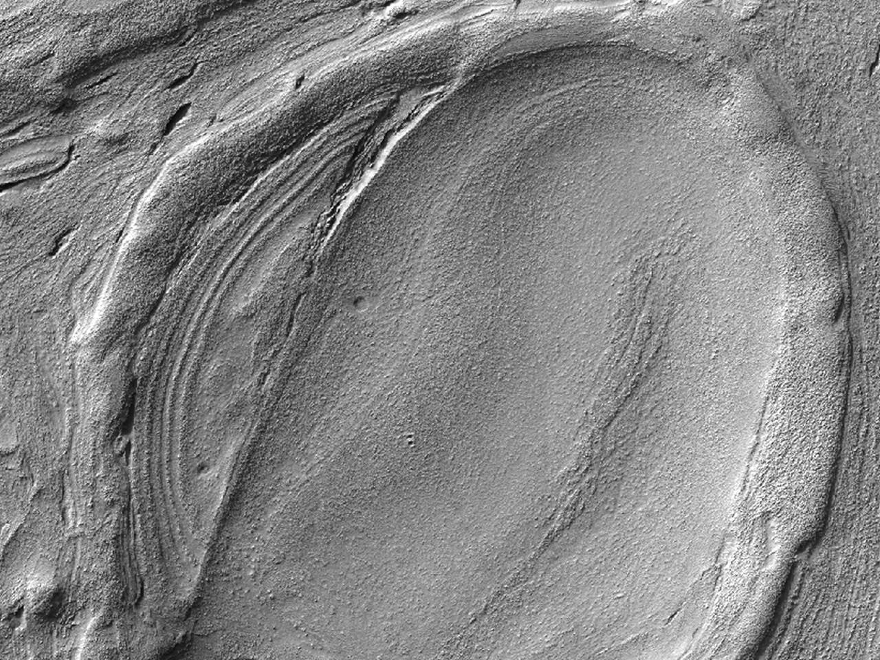
One of the “weirdest and least understood” areas of Mars, the enormous Hellas Impact Basin contains strange flowing landforms that bespeak of some specialized and large-scale geologic process having taken place. The HiRISE camera aboard NASA’s Mars Reconnaissance Orbiter recently captured the image above, showing what’s being called “lava lamp terrain” — stretched and contorted surface that looks like overworked modeling clay or pulled taffy… or, with a bit of imagination, the melted, mesmerizing contents of a party light from another era.
At 1,400 miles (2,300 km) across, Mars’ Hellas Basin is one of the largest impact craters in the entire Solar System. Its vast interior sinks to a depth of about 23,000 feet (7152 meters) below Mars’ average surface elevation (Martian “sea level”, if you will) and thus its floor is often shrouded by haze and dust, making visual imaging difficult.
The “lava lamp” terrain is just one of many different types of landforms that are found in the basin, although many of these banded features are found in the northwest area — which is also the deepest part of the basin. If there had been water in the region at some point in the planet’s history, it would have concentrated there.
Although the texture at first appears as if it could be volcanic in origin, it’s thought that flowing water or ice may actually be the source.
Researchers are currently working to determine how the Hellas Basin became so smoothly sculpted. Nicolas Thomas, Professor of Experimental Physics at the University of Bern, Switzerland, told Universe Today:
“There are a lot of very interesting images from this area and we are trying to get more data (including stereo) to understand better what’s going on and to try to establish what process is responsible for the numerous bizarre features we see. We are hoping to make some more progress in the next few months.”
Example of banded terrain. Compare the relatively fresh appearance of the bands with the older terrain seen to the left of this sub-image. (NASA/JPL/University of Arizona/N. Thomas et al.)
“Together with the observations of isolated areas and the lack of obvious caldera(s), it is difficult to envisage a volcanic origin for these features and we currently tend towards a mechanism involving ice,” Thomas stated in an abstract of a presentation given at the Europlanet Conference in 2010.
Read the full abstract here, and see this and more high-resolution images from Mars on the HiRISE website.
Tendrils of ice particles, called frazil, extend out into Antarctica's Mackenzie Bay. (NASA/EO-1 - ALI)
[/caption]
Ghostly green tendrils drift out into Mackenzie Bay off the coast of eastern Antarctica in this image, acquired by NASA’s Earth-Observing (EO-1) satellite on Feb. 12, 2012.
The tendrils are made of fine particles of ice called frazil, the result of upwelling cold water from deep beneath the Amery ice shelf.
Sea water flowing in currents under the Amery ice shelf gets cooled to temperatures below freezing, the result of greater water pressures existing at depth. As some of the water rises and flows along the underside of the shelf toward the open ocean, it gradually encounters less pressure since the ice thickness decreases the further away from shore it extends.
When the supercold water approaches the surface where pressure is lowest, it instantly freezes, forming needle-like ice particles called frazil.
Only 3 -4 millimeters wide, the frazil crystals can still be concentrated enough to be visible from orbit as it drifts into the bay, flowing around icebergs as it is carried along by wind and currents. (The largest iceberg in the image is a little over 4 km/2.5 miles long.)
Eventually the warmer surface water that surrounds the southern continent melts the frazil, and the tendrils fade away.
Scheduled to fly for a year and only designed to last a year and a half, EO-1 celebrated its eleventh anniversary on November 21, 2011. During its time in orbit the satellite has accomplished far more than anyone dreamed, and its Earth-observing mission continues on. Read more on the EO-1 site here.
Chaos terrain on Europa points to subsurface lakes, new research suggests. (NASA/JPL/Ted Stryk)
[/caption]
New research on Jupiter’s ice-covered moon Europa indicates the presence of a subsurface lake buried beneath frozen mounds of huge jumbled chunks of ice. While it has long been believed that Europa’s ice lies atop a deep underground ocean, these new findings support the possibility of large pockets of liquid water being much closer to the moon’s surface — as well as energy from the Sun — and ultimately boosting the possibility it could contain life.
During a press conference today, November 16 at 1 p.m. EST, researchers Britney Schmidt, Tori Hoeler, Louise Prockter and Tom Wagner presented new theories concerning the creation of “chaos terrain” on Europa.
Chaos terrain is exactly what it sounds like: irregularly-shaped landforms and surface textures on a world. In the case of Europa, the terrain is made of water ice that evidence shows has been loosened by the motion of liquid water beneath, expanded, and then has refrozen into hills and jagged mounds.
Topographic data shows the chaos terrain elevations above the surrounding surface. Reds and purples are the highest elevations. Credit: NASA
These mounds are visible in topographic data acquired by the Galileo spacecraft in 1998.
During the presentation a good analogy for the processes at work on Europa was made by Britney Schmidt, a postdoctoral fellow at the Institute for Geophysics, University of Texas at Austin and lead author of the paper. She demonstrated the formation of Europa’s “mosh pit of icebergs” using a drinking glass partially filled with ice cubes. When water was added to the glass, the ice cubes naturally rose up and shifted orientation. Should the water beneath them refreeze, as it would in the frigid environments found in the Jovian system, the ice cubes would be held fast in their new expanded, “chaotic” positions.
“Now we see evidence that it’s a thick ice shell that can mix vigorously, and new evidence for giant shallow lakes. That could make Europa and its ocean more habitable.”
– Britney Schmidt, lead author
Similar processes have also been seen occurring on Earth, both in Antarctica along the edges of ice shelves and in Greenland, where glaciers continually break apart and flow into the sea – often rolling over themselves and each other in the process.
Europa's "Great Lake." Scientists speculate many more exist throughout the shallow regions of the moon's icy shell. Image Credit: Britney Schmidt/Dead Pixel FX/Univ. of Texas at Austin.
The importance of these findings is that scientists finally have a model that demonstrates how Europa’s deep liquid ocean interacts with the ice near its surface in such a way as to allow for the transportation of energy and nutrients.
“This is the first time that anyone has come up with an end-to-end model that explains what we see on the surface,” said APL senior planetary scientist Louise Prockter.
With such strong evidence for this process, the likelihood that Europa could harbor environments friendly to life goes up dramatically.
“The potential for exchange of material between the surface and subsurface is a big key for astrobiology,” said Wes Patterson, a planetary scientist at the Johns Hopkins University Applied Physics Laboratory in Laurel, Md., and a co-author of the study. “Europa’s subsurface harbors much of what we believe is necessary for life but chemical nutrients found at the surface are likely vital for driving biology.”
Although the research favors the existence of these lakes, however, confirmation of such has not yet been found. That will require a future mission to Europa and the direct investigation of its icy surface – and what lies beneath.
Luckily a Europa mission was recently rated as one of the highest priority flagship missions by the National Research Council’s Planetary Science Decadal Survey and is currently being studied by NASA.
“If we’re ever to send a landed mission to Europa, these areas would be great places to study,” Prockter said.
Read more about this discovery in the Johns Hopkins University Applied Physics Laboratory press release, or in the NASA news release here. Also, watch the full conference recorded on Ustream below:
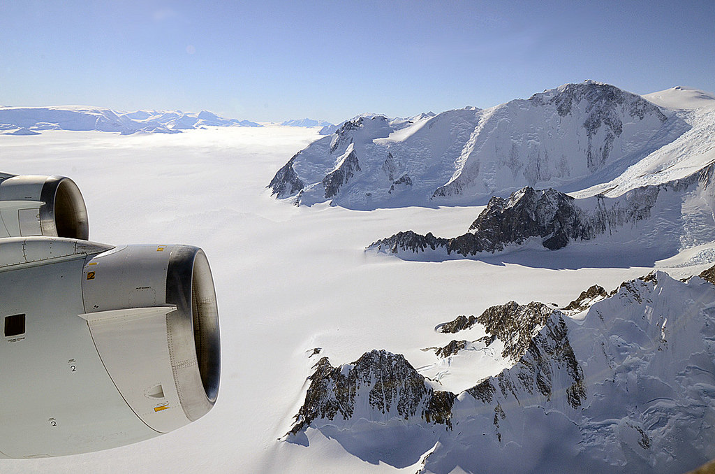
Ice-coated mountaintops of Alexander Island, one of the largest islands off Antarctica. Credit: Michael Studinger/NASA.
[/caption]
Views from the window of NASA’s DC-8 reveal sweeping expanses of ice and rock as part of the ongoing 2011 Operation IceBridge survey of Antarctica’s ice cover.
Now in its third season, Operation IceBridge is a six-year-long mission to study the dynamics of the Antarctic and Arctic ice sheets. It’s the largest ever aerial survey of the polar ice and will yield valuable data on the state of Earth’s vast reservoirs of frozen water, including the land and sea underneath and how they are being affected by today’s rapidly changing climate.
The ridges of the Shackleton Range cast shadows onto Antarctica's ice. Credit: Michael Studinger/NASA.
Researchers – like Michael Studinger, who took the incredible photos seen here – fly over Greenland during the months of March through May and over Antarctica in October and November. NASA’s instrument-laden DC-8 flies over these remote locations at a low altitude of about 1,500 feet, often with little or no advance weather data.
98 percent of Antarctica is covered with ice. Information obtained by Operation IceBridge will be combined with satellite data to create the most accurate models possible of Antarctic ice loss and how it will affect future sea level rise.
Mountains piled with snow and ice rise above the clouds on Alexander Island. Credit: Michael Studinger/NASA.
This season’s Antarctic IceBridge campaign features NASA’s DC-8, at 157 feet long the largest plane in the agency’s airborne research fleet, and will also feature the debut of the Gulfstream V (G-V) operated by the National Science Foundation and National Center for Atmospheric Research.
While the DC-8 flies at low altitudes, the G-V will fly above 30,000 feet to utilize its Land, Vegetation and Ice Sensor (LVIS), which makes detailed topographic studies of the surface.
“With IceBridge, our aim is to understand what the world’s major ice sheets could contribute to sea-level rise. To understand that you have to record how ice sheets and glaciers are changing over time.”
– Michael Studinger, IceBridge project scientist at NASA’s Goddard Space Flight Center in Greenbelt, Md.
The wing of NASA's DC-8 cuts across the frozen expanse of the Brunt Ice Shelf, with its 100-foot-high cliff face. Credit: Michael Studinger/NASA.
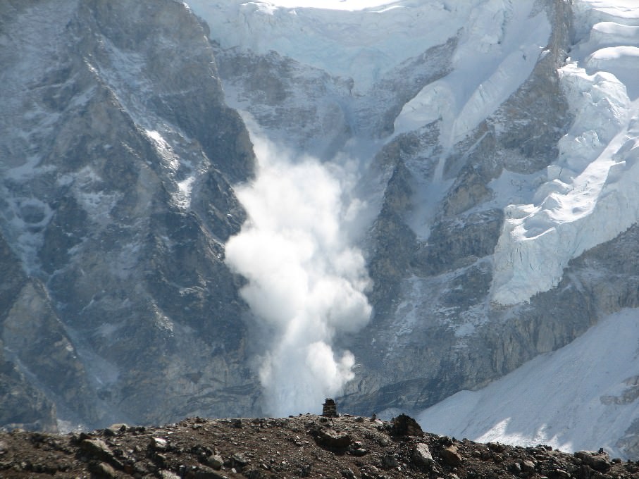
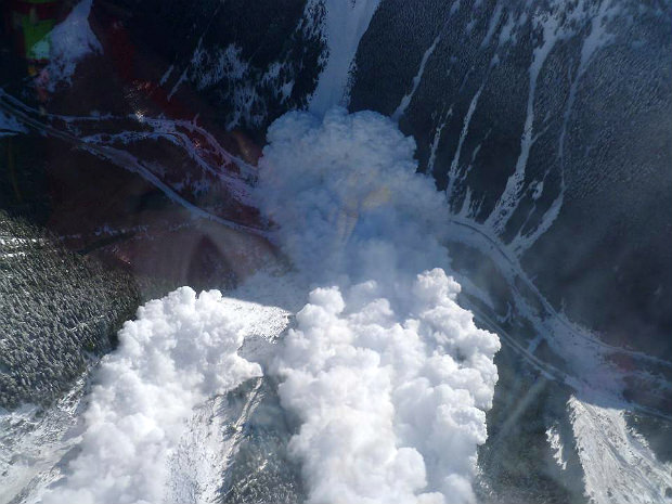
A powder snow avalanche in the Himalayas near Mount Everest. Credit: Wikipeida Commons/ Ilan Adler
Have you ever noticed how the snow packs on a car windshield after a heavy snowfall? While the temperature is cold, the snow sticks to the surface and doesn’t slide off. After temperatures warm up a little, however, the snow will slide down the front of the windshield, often in small slabs. This is an avalanche on a miniature scale.
On the other hand, a mountain avalanche in North America might release 229,365 cubic meters (300,000 cubic yards) of snow. That’s the equivalent of 20 football fields filled 10 feet deep with snow. However, such large avalanches are often naturally released. They are primarily composed of flowing snow but given their power, they are also capable of carrying rocks, trees, and other forms of debris with them.
In mountainous terrain avalanches are among the most serious objective hazards to life and property, with their destructive capability resulting from their potential to carry an enormous mass of snow rapidly over large distances.
Classification:
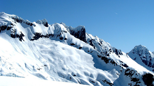
Avalanches are classified based on their form and structure, which are also known as “morphological characteristics”. Some of the characteristics include the type of snow involved, the nature of what caused the structural failure, the sliding surface, the propagation mechanism of the failure, the trigger of the avalanche, the slope angle, direction, and elevation.
Loose snow avalanches (far left) and slab avalanches (near center) near Mount Shuksan in the North Cascades mountains. Credit: Thermodynamic/Wikipedia Commons
All avalanches are rated by either their destructive potential or the mass they carry. While this varies depending on the geographical region – – all share certain common characteristics, ranging from small slides (or sluffs) that pose a low risk to massive slides that come that pose a significant risk.
An avalanche has three main parts: the starting zone, the avalanche track, and the runout zone. The starting zone is the most volatile area of a slope, where unstable snow can fracture from the surrounding snowcover and begin to slide. The avalanche track is the path or channel that an avalanche follows as it goes downhill. The runout zone is where the snow and debris finally come to a stop.
Causes:
Several factors may affect the likelihood of an avalanche, including weather, temperature, slope steepness, slope orientation (whether the slope is facing north or south), wind direction, terrain, vegetation, and general snowpack conditions. However, weather remains the most likely factor in triggering an avalanche.
During the day, as temperatures increase in a mountainous region, the likelihood of an avalanche increases. Regardless of the time of year, an avalanches will only occur when the stress on the snow exceeds the strength either within the snow itself or at the contact point where the snow pack meets the ground or the rock surface.
An avalanche east of the town of Revelstoke, BC, in 2010 Credit: Canadian Avalanche Center
Although avalanches can occur on any slope given the right conditions, in North America certain times of the year and certain locations are naturally more dangerous than others. Wintertime, particularly from December to April, is when most avalanches will occur with the highest number of fatalities occurs in January, February and March, when the snowfall amounts are highest in most mountain areas.
Deaths Caused by Avalanches:
In the United States, 514 avalanche fatalities have been reported in 15 states from 1950 to 1997. In the 2002–2003 season there were 54 recorded incidents in North America involving 151 people.
In Canada’s mountainous province of British Columbia, a total of 192 avalanche-related deaths were reported between January 1st, 1996 and March 17th, 2014 – an average of roughly ten deaths per year. During the winter of 2014, avalanche concerns also forced the closure of the Trans-Canada highway on a number of occasions.
Avalanches on Other Planets:
Not too surprisingly, Earth is not the only planet in the Solar System to experience avalanches. Wherever their is mountainous terrain and water ice, which is not uncommon, there is the likelihood that material will come loose and cause a cascading slide to take place.
On February 19th, 2008, NASA’s Mars Reconnaissance Orbiter captured the first ever image of active avalanches taking place the Red Planet. The avalanche occurred near the north pole, where water ice exists in abundance, and was captured by the MRO’s HiRISE (High Resolution Imaging Experiment) camera completely by accident.
Images taken by the MRO’s HiRISE camera show at least four Martian avalanches, or debris falls, taking place near the north pole. Credit: NASA/JPL
The images showed material – likely to include fine-grained ice dust and possibly large blocks – detaching from a towering cliff and cascading to the gentler slops below. The occurrence of the avalanches was spectacularly revealed by the accompanying clouds of fine material (visible in the photographs) that continue to settle out of the air.
The largest cloud (shown in the upper images) was about 180 meters (590 feet) across and extended about 190 meters (625 feet) from the base of the steep cliff. Shadows to the lower left of each cloud illustrate further that these are three dimensional features hanging in the air in front of the cliff face, and not markings on the ground.
The photo was unprecedented because it allowed NASA scientists to get a glimpse of a dramatic change on the Martian surface while it was happening. Despite seeing countless pictures that have detailed the planet’s geological features, most appear to have remained unchanged for several million years. It also showed that terrestrial events like avalanches are not confined to planet Earth.
The circular black features in this 2007 figure are caves formed by the collapse of lava tubes on Mars. Image credit: NASA/JPL-Caltech/ASU/USGS
[/caption]
New results published in the journal Icarus suggest that caves on Mars may provide future astronauts with more than just shelter. In many locations, even far from the poles, the caves may actually trap water ice.
Ice caves are made of rock, but they contain ice year-round. (Not to be confused with glacier caves, which are caves made of ice!) Ice caves can be found on the Earth even where surface temperatures are above freezing for months at a time. This happens because cold winter air sinks into the cave and is trapped, but during the summer, the circulation in the cave shuts off: it is full of dense cold air so the warm air outside can’t get in.
Now, in a study led by Kaj Williams of NASA Ames, scientists have used simulations of the global climate and assumptions about the thermal properties of the surface to figure out where on Mars similar cold-trapping might occur. Their results show that a significant portion of the martian surface has the right conditions for ice to accumulate in caves.
Even more tantalizing, the huge volcanic provinces of Tharsis and Elysium look to be particularly good at accumulating ice. This is important because caves formed by collapsing lava tubes have been seen on the flanks of these volcanoes. Lava tube caves on Earth tend to have limited air circulation, making them good candidates for ice accumulation.
Astronauts on the surface of Mars will likely need to take cover underground to avoid the harsh radiation environment of the surface. Natural caves such as lava tubes have been suggested as ideal ready-made shelters for astronauts, and they are only looking better. Not only could ice caves provide water as a resource, the ice could preserve valuable records of past climate cycles, and the caves may be important habitats for past or present martian life.
Williams and his team plan to continue refining their models, particularly focusing on the Tharsis and Elysium regions, using higher-resolution atmospheric models and more precise geologic data to pinpoint areas that are best for cave-ice formation.