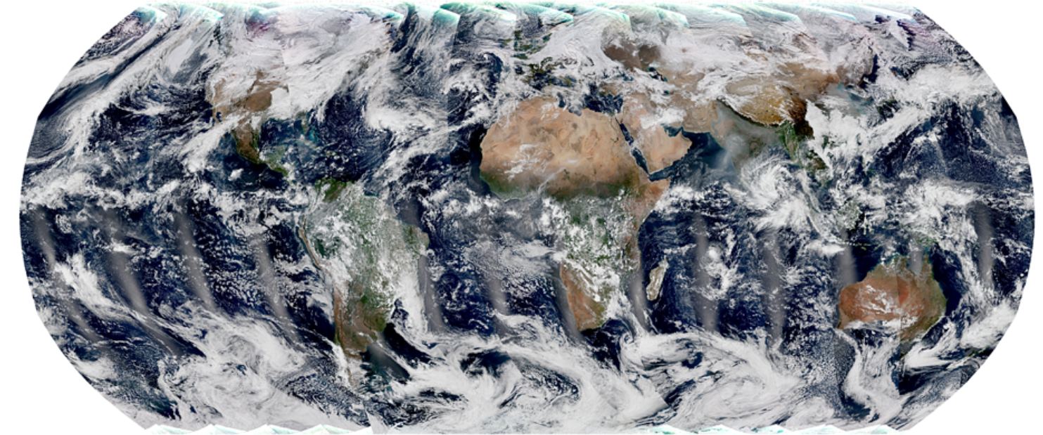
Polar-orbiting satellites capture swaths of data throughout the globe, and observe the entire planet twice each day. The global mosaic, captured by the VIIRS instrument on the recently launched NOAA-21 satellite, is a composite image created from these swaths. Image Credit: NOAA STAR VIIRS Imagery Team.
You’d have to be in some kind of sense-of-wonder-repressed coma not to appreciate satellite images of Earth. If you are, then images from the NOAA’s newest satellite might pull you out of it.
And they’re only a taste of the fascinating images that it will provide.
Using the microlensing metthod, a team of astrophysicists have found the first extra-galactic planets! Credit: NASA/Tim Pyle
The study of exoplanets has advanced by leaps and bounds in the past few decades. Between ground-based observatories and spacecraft like the Kepler mission, a total of 3,726 exoplanets have been confirmed in 2,792 systems, with 622 systems having more than one planet (as of Jan. 1st, 2018). And in the coming years, scientists expect that many more discoveries will be possible thanks to the deployment of next-generation missions.
These include NASA’sJames Webb Space Telescope (JWST) and several next-generation ground based observatories. With their advanced instruments, these and other observatories are not only expected to find many more exoplanets, but to reveal new and fascinating things about them. For instance, a recent study from Columbia University indicated that it will be possible, using the Transit Method, to study surface elevations on exoplanets.
The study, which recently appeared online under the title “Finding Mountains with Molehills: The Detectability of Exotopography“, was conducted by Moiya McTier and David Kipping – and graduate student and an Assistant Professor of Astronomy at Columbia University, respectively. Based on models they created using bodies in our Solar System, the team considered whether transit surveys might be able to reveal topographical data on exoplanets.
Artist’s impression of an extra-solar planet transiting its star. Credit: QUB Astrophysics Research Center
To recap, the Transit Method (aka. Transit Photometry) is currently the most popular and reliable means for detecting exoplanets. It consists of astronomers measuring the light curve of distant stars over time and looking for periodic dips in brightness. These dips are the result of exoplanets passing in front of the star (i.e. transiting) relative to the observer.
By measuring the rate at which the star’s light dips, and the period with which the dimming occurs, astronomer are not only able to determine the presence of exoplanets, but also place accurate constraints on their size and orbital periods. According to McTier and Kipping, this same method could also reveal the presence of geographical features – for instance, mountain ranges, volcanoes, trenches, and craters.
As they indicate in their study, in lieu of direct imaging, indirect methods are the only means astronomers have for revealing data on an exoplanet’s surface. Unfortunately, there is no conceivable way that the radial velocity, microlensing, astrometry, and timing methods could reveal exotopography. This leaves the transit method, which has some potential in this respect. As they state:
“The transit method directly measures the sky-projected area of a planet’s silhouette relative to that of a star, under the assumption that the planet is not luminous itself… This fact implies that there is indeed some potential for transits to reveal surface features, since the planet’s silhouette is certainly distorted from a circular profile due to the presence of topography.”
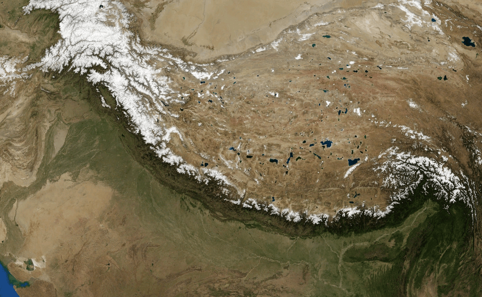
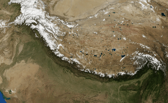
Satellite image of the Himalayan mountain chain, as imaged by NASA’sLandsat-7 imagery of Himalayas. Credit: NASA
In other words, as a planet transits in front of its host star, the light passing around the planet itself could be measured for small variations. These could indicate the presence of mountain ranges and other large-scale features like massive chasms. To test this theory, they considered planets in the Solar System as templates for how the scattering of light during a transit could reveal large-scale features.
As an example, they consider what an Earth analog planet would reveal if the Himalayan mountain range ran from north to south and was wide enough to span 1° in longitude:
“Now assume that the planet completes half of one rotation as it transits its parent star from our point of view, which is all that is necessary to see all of the planet’s features appear on its silhouette without repeating. As our hypothetical planet rotates and the Himalayan block moves into and out of view, the change in silhouette will result in different transit depths…”
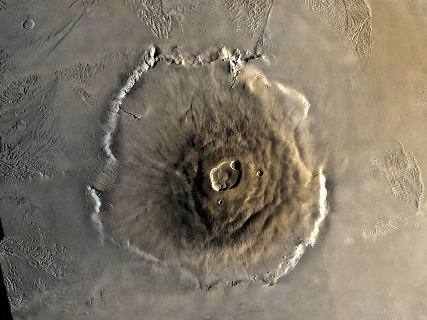
Ultimately, they consider that Mars would be the ideal test case due to its combination of small size, low surface gravity, and active internal volcanism, which has caused it become what they describe as the “bumpiest body in the Solar System”. When paired with a white dwarf star, this presents the optimal case for using light curves to determine exotopography.
Color mosaic of Mars’ greatest mountain, Olympus Mons, viewed from orbit. Credit NASA/JPL
At a distance of about 0.01 AU (which would be within a white dwarf’s habitable zone), they calculate that a Mars-sized planet would have an orbital period of 11.3 hours. This would allow for many transits to be observed in a relatively short viewing period, thus ensuring a greater degree of accuracy. At the same time, the team admits that their proposed methods suffers from drawbacks.
For instance, due to the presence of astrophysical and instrumental noise, they determined that their method would be unproductive when it comes to studying exoplanets around Sun-like stars and M-type (red dwarf) stars. But for Mars-like planets orbiting low mass, white dwarf stars, the method could produce some highly valuable scientific returns.
While this might sound rather limited, it would present some rather fascinating opportunities to learn more about planets beyond our Solar System. As they explain:
“Finding the first evidence of mountains on planets outside our solar system would be exciting in its own right, but we can also infer planet characteristics from the presence and distribution of surface features. For example, a detection of bumpiness could lead to constraints on a planet’s internal processes.”
In short, planets with a high degree of bumpiness would indicate tectonic activity or the buildup of lava caused by internal heating sources. Those with the highest bumpiness (i.e. like Mars) would indicate that they too experience a combination internal processes, low surface gravity, volcanism, and a lack of tectonic plate movement. Meanwhile, low-bumpiness planets are less likely to have any of these internal processes and their surfaces are more likely to be shaped by external factors – like asteroid bombardment.
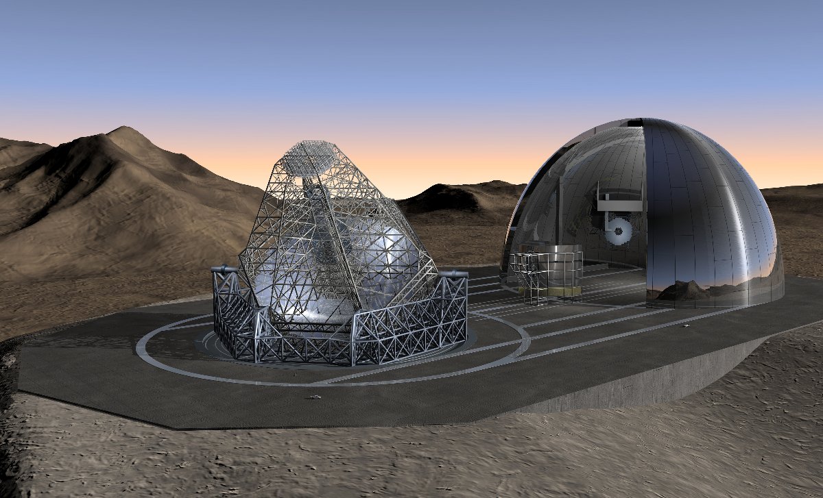
Artist’s impression of the OWL Telescope being deployed at night from its enclosure, where it will operated during the daytime. Credit: ESO
Based on their estimates, they conclude that the various super telescopes that are scheduled to be commissioned in the coming years would be up to task. These include the ESO’s OverWhelmingly Large (OWL) Telescope, a 100-meter proposed optical and near-infrared telescope that would build on the success of the Very Large Telescope (VLT) and the upcoming Extremely Large Telescope (ELT).
Another example is the Colossus Telescope, a 74-meter optical and infrared telescope that is currently being commissioned by an international consortium. Once operational, it will be the largest telescope optimized for detecting extrasolar life and extraterrestrial civilizations.
In the past, the success of exoplanet hunters has come down to a combination of factors. In addition to greater levels of cooperation between institutions, amateur astronomers and citizen scientists, there has also been the way in which improved technology has coincided with new theoretical models. As more data become available, scientists are able to produce more educated estimates on what we might be able to learn once new instruments come online.
When the next-generation telescopes take to space or are finished construction here on Earth, we can anticipate that thousands more exoplanets will be found. At the same time, we can anticipate that important details will be also discovered about these planets that were not possible before. Do they have atmospheres? Do they have oceans? Do they have mountain ranges and chasms? We hope to find out!
Mount Everest from Kalapatthar. Photo: Pavel Novak
When beholding the sheer size and majesty of mountains, ancient humans could not help but feel that they were standing in the presence of something… godlike. And within the belief systems of many ancient cultures, it was generally felt that mountains were something spiritual – either serving as the home of the Gods, a result of their activity, or a place to get closer to God.
Thanks to modern geology, we now know the true story of how mountains are formed. Simply put, they are the result of tectonic forces or volcanism. But knowing this has not diminished their impressive and awe-inspiring nature. When a geological formation is created through forces that can only be described as titanic, this is to be expected. But just how are mountains formed?
In truth, there are three ways in which mountains are formed, which correspond to the types of mountains in question. These are known as volcanic, fold and block mountains. All of these are the result of plate tectonics, where compressional forces, isostatic uplift and intrusion of igneous matter forces surface rock upward, creating a landform higher than the surrounding features.
Over the course of many million years, these uplifted sections are eroded by the elements – wind, rain, ice and gravity. These gradually wear the surface of the mountains down, cause the surface to be younger than the rocks that form them, and lead to the types of formations and distributions we are familiar with today.
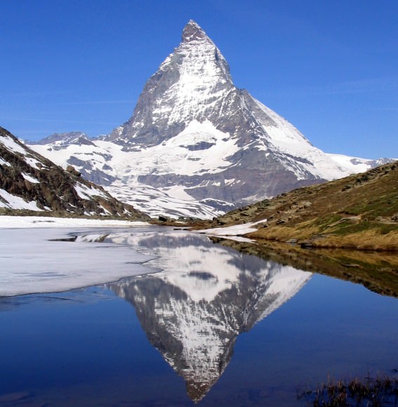
The East side of the Matterhorn, a fold mountain that measures 4,478 meters in height, mirrored in lake Riffelsee. Credit: Wikipedia Commons/Dirk Beyer
Volcanic Mountains:
Volcanic mountains are formed when a tectonic plate is pushed beneath another (or above a mid-ocean ridge or hotspot) where magma is forced to the surface. When the magma reaches the surface, it often builds a volcanic mountain, such as s shield volcano or a stratovolcano. Examples of this sort of mountains include Mount Fuji in Japan, Mauna Kea in Hawaii, Nyamuragira in the Democratic Republic of Congo, Skjaldbreiður in Iceland and Mount Etna in Sicily.
At other times, the rising magma solidifies below the surface and forms dome mountains, where material is pushed up from the force of the build-up beneath it. Examples of this formation include Navajo Mountain in San Juan County, Utah; the Chaitén lava dome of Chile, Torfajökull in Iceland, and Mount St. Helens in Washington State.
Fold Mountains:
As the name suggests, fold mountains occur when two tectonic plates collide at a convergent plate boundary, causing the crust to overthicken. This process forces the less dense crust to float on top of the denser mantle rocks – with material being forced upwards to form hills, plateaus or mountains – while a greater volume of material is forced downward into the mantle.
Satellite image of the Himalayan mountain chain, as imaged by NASA’s Landsat-7 satellite. Credit: NASA
The Jura Mountains, a series of sub-parallel mountain ridges located in the Alps, are an example of fold mountains. Other examples include the “Simply Folded Belt” of the Zagros mountains, which extends from northern Syria and southern Turkey to eastern Iran and the Persian Gulf. There is also the Akwapim-Togo ranges in Ghana and the Ridge-and-Valley Appalachians in the Eastern United States.
But perhaps most famous is the Himalayan mountain chain, located between northern India and Nepal. This chain formed as a result of the collision between the Indian subcontinent and Asia some 25 million years ago, and has given rise to the tallest mountain in the world – Mt. Everest.
Block Mountains:
Block mountains are caused by faults in the crust, a seam where rocks can move past each other. Also known as rifting, this process occurs when rocks on one side of a fault rise relative to the other. The uplifted blocks become block mountains (also known as horsts) while the intervening dropped blocks are known as graben (i.e. depressed regions).
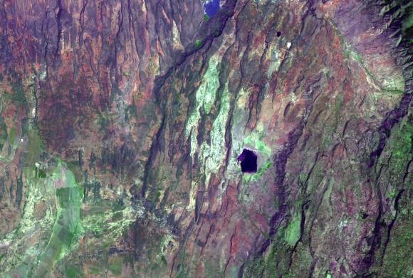
Examples of this type of terrain can be found in the Upper Rhine valley, the Vosges mountains in France, the Black Forest in Germany, and the Vindhya and Satpura horsts in India. There is also the East African Rift, an active continental rift zone with several active volcanoes that extends from Eritrea to Mozambique.
Satellite image of the East African Rift, taken on December 18th, 2002. Credit: NASA/GSFC/METI/Japan Space Systems/U.S.-Japan ASTER Science Team
Mountain Erosion:
As noted, the final way in which mountains are formed is through erosion. This occurs during and after an uplift, where a newly formed mountainous region is subjected to the effects of wind, water, ice, and gravity. These forces actively shape the surface of mountain ranges, wearing down the exposed surfaces, depositing sediment in alluvial flows, and leading to the formation of characteristic landforms.
These include pyramidal peaks, knife-edge arêtes, and bowl-shaped cirques that can contain lakes. Plateau mountains, such as the Catskills, are formed from the erosion of an uplifted plateau. And after millions of years of erosion, mountains may cease to exist entirely.
Given the size and scale of a mountain, the immense forces involved in their creation, and the immense amount of time it takes to shape and form them, it is little wonder why they are considered such a big deal. Between their religious significance (i.e. Mount Zion, Mount Olympus, Mount Ararat, and Mauna Kea, to name a few), their scenic value, the challenge they present, and their importance to the Earth sciences, these geological formations continue to enjoy a special place in our hearts, minds and culture.
As we explore other planets, we have also found new and impressive mountain formations that have taught us much about the geological activity and composition of other worlds. For example, there the volcanic mountain on Mars known as Olympus Mons, which just happens to be the largest mountain in the Solar System. And this is merely a drop in the bucket. Wherever there’s a geologically active planet, there’s mountains to be found!