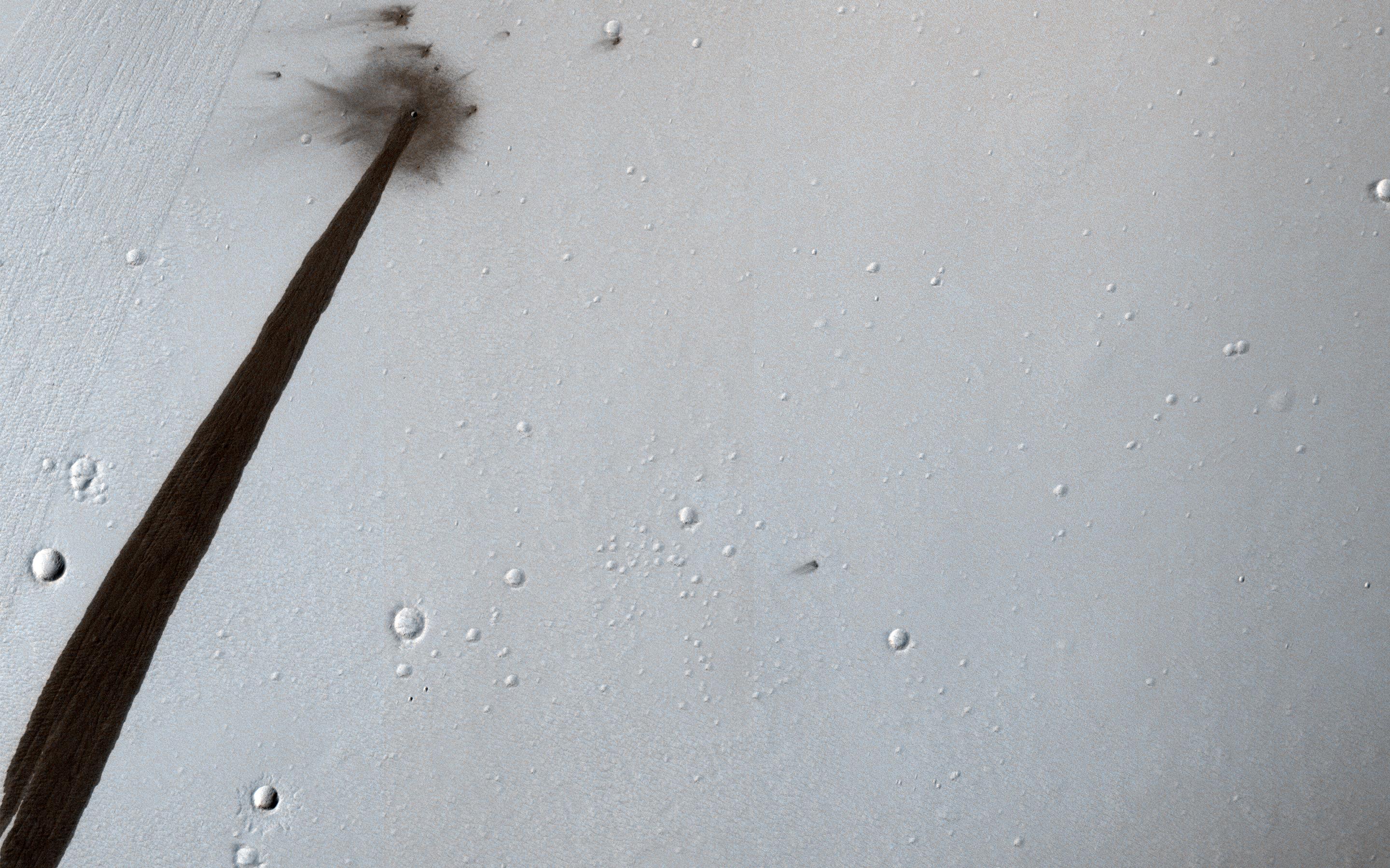
HiRISE image from NASA's Mars Reconnaissance Orbiter (MRO) showing an impact crater that triggered a slope streak. Credit: NASA/JPL/University of Arizona
In 2006, NASA’s Mars Reconnaissance Orbiter (MRO) established orbit around the Red Planet. Using an advanced suite of scientific instruments – which include cameras, spectrometers, and radar – this spacecraft has been analyzing landforms, geology, minerals and ice on Mars for years and assisting with other missions. While the mission was only meant to last two years, the orbiter has remained in operation for the past twelve.
In that time, the MRO has acted as a relay for other missions to send information back to Earth and provided a wealth of information of its own on the Red Planet. Most recently, it captured an image of an impact crater that caused a landslide, which left a long, dark streak along the crater wall. Such streaks are created when dry dust collapses down the edge of a Martian hill, leaving behind dark swaths.
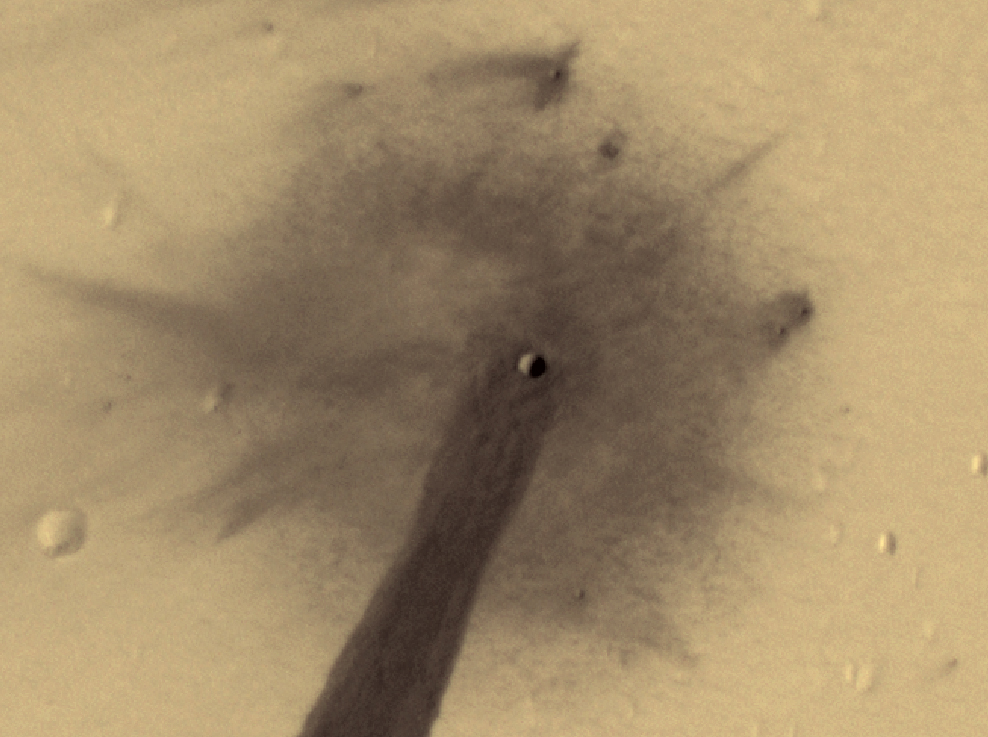
Close up of the crater captured by the MRO’s HiRISE instrument. Credit: NASA/JPL/University of Arizona
In this respect, these avalanches are not unlike Recurring Slope Lineae (RSL), where seasonal dark streaks appear along slopes during warmer days on Mars. These are believed to be caused by either salt water flows or dry dust grains falling naturally. In this case, however, the dry dust on the slope was destabilized by the meteor’s impact, which exposed darker material beneath.
The impact that created the crater is believed to have happened about ten years ago. And while the crater itself (shown above) is only 5 meters (16.4 feet) across, the streak it resulted in is 1 kilometer (0.62 mi) long! The image also captured the faded scar of an old avalanche, which is visible to the side of the new dark streak.
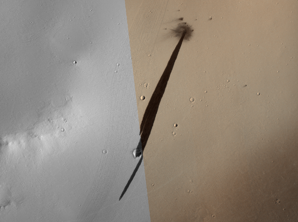
Wider-angle view of the impact crater captured by the MRO’s HiRISE instrument and the resulting dark streak. Credit: NASA/JPL/University of Arizona
This is just the latest in a long-line of images and data packages sent back by the MRO. By providing daily reports on Mars’ weather and surface conditions, and studying potential landing sites, the MRO also paves the way for future spacecraft and surface missions. In the future, the orbiter will serve as a highly capable relay satellite for missions like NASA’s Mars 2020 rover, which will continue in the hunt for signs of past life on Mars.
At present, the MRO has enough propellant to keep functioning into the 2030s, and given its intrinsic value to the study of Mars, it is likely to remain in operation right up until it exhausts its fuel. Perhaps it will even be working when astronauts arrived on the Red Planet?
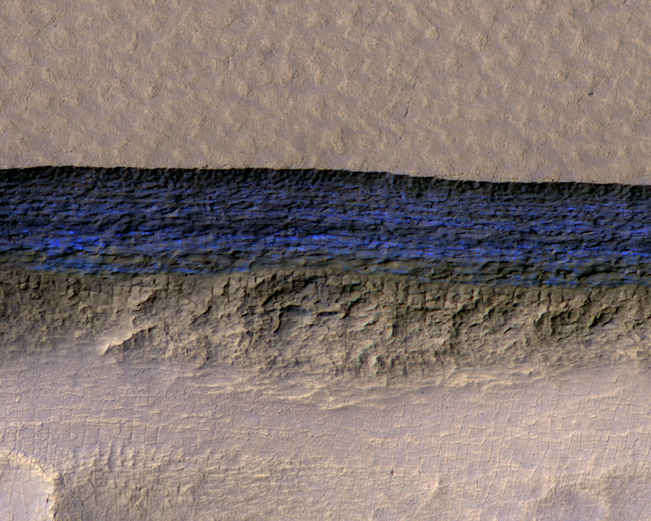
A cross-section of underground ice is exposed at the steep slope that appears bright blue in this enhanced-color view from the HiRISE camera on NASA's Mars Reconnaissance Orbiter. Credits: NASA/JPL-Caltech/UA/USGS
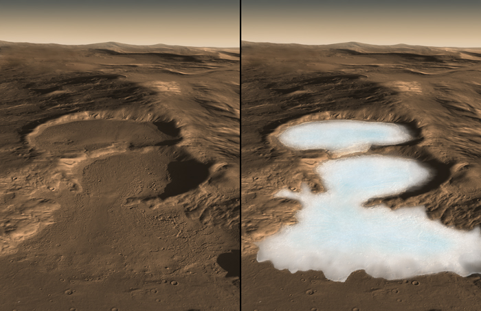
Its an established fact that Mars was once a warmer and wetter place, with liquid water covering much of its surface. But between 4.2 and 3.7 billion years ago, the planet lost its atmosphere, which caused most of its surface water to disappear. Today, much of that water remains hidden beneath the surface in the form of water ice, which is largely restricted to the polar regions.
In recent years, scientists have also learned of ice deposits that exist in the equatorial regions of Mars, though it was unlcear how deep they ran. But according to a new study led by the U.S. Geological Survey, erosion on the surface of Mars has revealed abundant deposits of water ice. In addition to representing a major research opportunity, these deposits could serve as a source of water for Martian settlements, should they ever be built.
Artists concept of the Mars Reconnaisance Orbiter (MRO). Credit: NASA/JPL
For the sake of their study, the team consulted data obtained by the High Resolution Imaging Science Experiment (HiRISE) aboard the Mars Reconnaissance Orbiter (MRO). This data revealed eight locations in the mid-latitude region of Mars where steep slopes created by erosion exposed substantial quantities of sub-surface ice. These deposits could extend as deep as 100 meters (328 feet) or more.
The fractures and steep angles indicate that the ice is cohesive and strong. As Dundas explained in a recent NASA press statement:
“There is shallow ground ice under roughly a third of the Martian surface, which records the recent history of Mars. What we’ve seen here are cross-sections through the ice that give us a 3-D view with more detail than ever before.”
These ice deposits, which are exposed in cross-section as relatively pure water ice, were likely deposited as snow long ago. They have since become capped by a layer of ice-cemented rock and dust that is between one to two meters (3.28 to 6.56 ft) thick. The eight sites they observed were found in both the northern and southern hemispheres of Mars, at latitudes from about 55° to 58°, which accounts for the majority of the surface.
It would be no exaggeration to say that this is a huge find, and presents major opportunities for scientific research on Mars. In addition to affecting modern geomorphology, this ice is also a preserved record of Mars’ climate history. Much like how the Curiosity rover is currently delving into Mars’ past by examining sedimentary deposits in the Gale Crater, future missions could drill into this ice to obtain other geological records for comparison.
At this pit on Mars, the steep slope at the northern edge (toward the top of the image) exposes a cross-section of a thick sheet of underground water ice. Credits: NASA/JPL-Caltech/UA/USGS
These ice deposits were previously detected by the Mars Odyssey orbiter (using spectrometers) and ground-penetrated radar aboard the MRO and the ESA’s Mars Express orbiter. NASA also sent the Phoenix lander to Mars in 2008 to confirm the findings made by the Mars Odyssey orbiter, which resulted in it finding and analyzing buried water ice located at 68° north latitude.
However, the eight scarps that were detected in the MRO data directly exposed this subsurface ice for the first time. As Shane Byrne, the University of Arizona Lunar and Planetary Laboratory and a co-author on the study, indicated:
“The discovery reported today gives us surprising windows where we can see right into these thick underground sheets of ice. It’s like having one of those ant farms where you can see through the glass on the side to learn about what’s usually hidden beneath the ground.”
These studies would also help resolve a mystery about how Mars’ climate changes over time. Today, Earth and Mars have similarly-tiled axes, with Mars’ axis tilted at 25.19° compared to Earth’s 23.439°. However, this has changed considerably over the course of eons, and scientists have wondered how increases and decreases could result in seasonal changes.
Artist’s impression of glaciers that may have existed on the surface of Mars in the past. Credit: NASA/Caltech/JPL/UTA/UA/MSSS/ESA/DLR Eric M. De Jong, Ali Safaeinili, Jason Craig, Mike Stetson, Koji Kuramura, John W. Holt
Basically, during periods where Mars’ tilt was greater, climate conditions may have favored a buildup of ice in the middle-latitudes. Based on banding and color variations, Dundas and his colleagues have suggested that layers in the eight observed regions were deposited in different proportions and with varying amounts of dust based on varying climate conditions.
As Leslie Tamppari, the MRO Deputy Project Scientist at NASA’s Jet Propulsion Laboratory, said:
“If you had a mission at one of these sites, sampling the layers going down the scarp, you could get a detailed climate history of Mars. It’s part of the whole story of what happens to water on Mars over time: Where does it go? When does ice accumulate? When does it recede?”
The presence of water ice in multiple locations throughout the mid-latitudes on Mars is also tremendous news for those who want to see permanent bases constructed on Mars someday. With abundant water ice just a few meters below the surface, and which is periodically exposed by erosion, it would be easily accessible. It would also mean bases need not be built in polar areas in order to have access to a source of water.
This research was made possible thanks to the coordinated use of multiple instruments on multiple Mars orbiters. It also benefited from the fact that these missions have been studying Mars for extended periods of time. The MRO has been observing Mars for 11 years now, while the Mars Odyssey probe has been doing so for 16. What they have managed to reveal in that time has provided all kinds of opportunities for future missions to the surface.
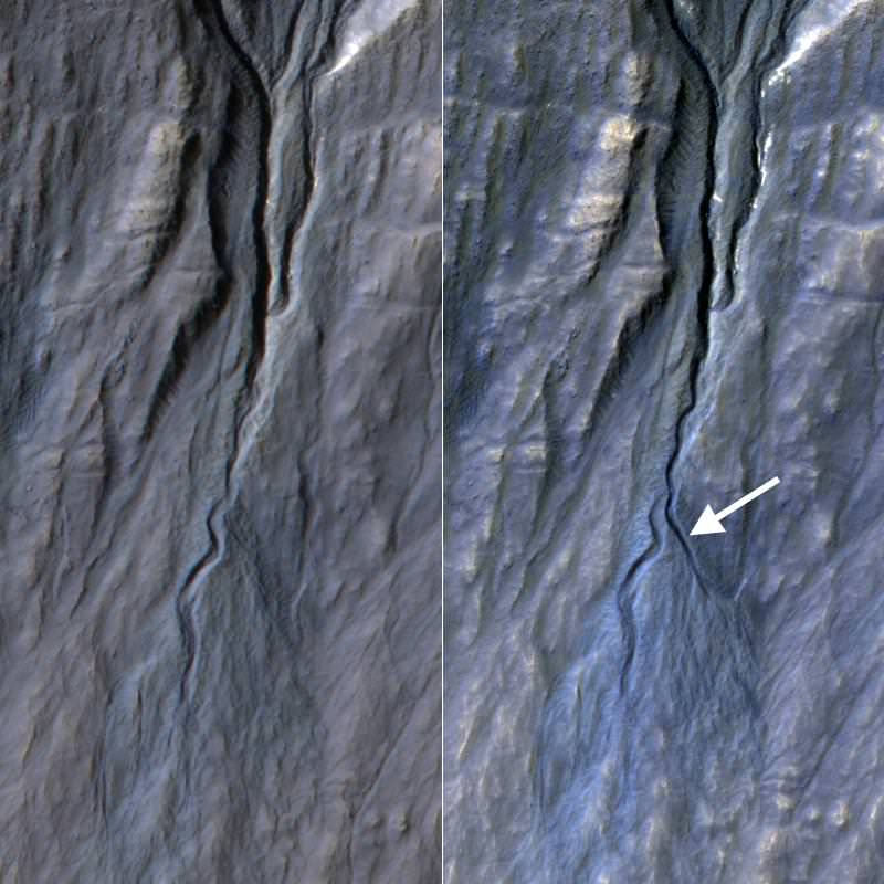
At right, a new gully appears in pictures of the same region of Terra Sirenum on Mars. The picture at left was taken in November 2010, and the right in May 2013. Credit: NASA/JPL-Caltech/Univ. of Arizona
Check out the groove! In the blink of a geological lifetime, a new gully has appeared on the planet Mars. These images from NASA’s Mars Reconnaissance Orbiter show a new channel in the southern hemisphere region of Terra Siernum that appeared between November 2010 and May 2013.
While there’s a lot of chatter about water on Mars, this particular feature is likely not due to that liquid, the agency added.
“Gully or ravine landforms are common on Mars, particularly in the southern highlands. This pair of images shows that material flowing down from an alcove at the head of a gully broke out of an older route and eroded a new channel,” NASA stated.
It’s unclear in what season the activity occurred because the observations took place more than a Martian year apart, NASA added. These ravines tend to happen in the southern highlands and other mid-latitude regions on Mars.
“Before-and-after HiRISE pairs of similar activity at other sites demonstrate that this type of activity generally occurs in winter, at temperatures so cold that carbon dioxide, rather than water, is likely to play the key role,” the agency said.
Last week, the agency also announced that MRO recovered from an unplanned computer swap that put the spacecraft into safe mode. Incidents of this nature have happened four times before, the agency noted.
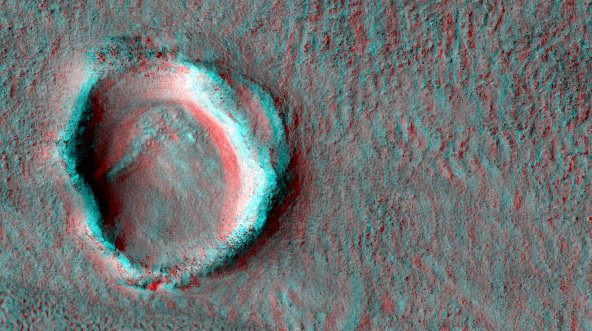
A crater imaged by the Mars Reconnaissance Orbiter's HiRISE (High Resolution Imaging Science Experiment). Credit: NASA/JPL/University of Arizona
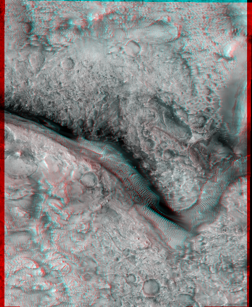
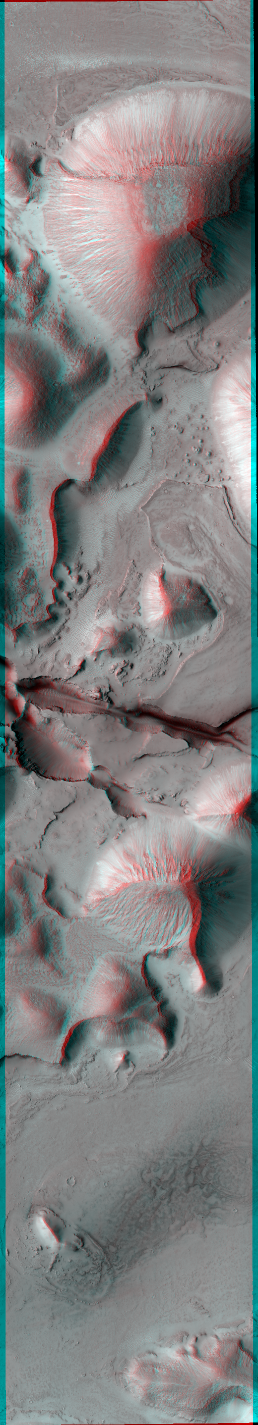
Stop what you’re doing, grab the nearest 3-D glasses (red/blue type) you have available and then pretend you’re hovering above Mars for a while. These are some of the latest images from the Mars Reconnaissance Orbiter, which has been cruising above the planet since 2006.
“Candidate Future Landing Site at Valley North of Jezero Crater”, imaged by the Mars Reconnaissance Orbiter’s HiRISE (High Resolution Imaging Science Experiment). Credit: NASA/JPL/University of Arizona“Fossae Source of Outflows,” a picture taken by Mars Reconnaissance Orbiter’s HiRISE (High Resolution Imaging Science Experiment). Credit: NASA/JPL/University of Arizona“Floor of East Candor Chasma,” a picture taken by the Mars Reconnaissance Orbiter’s HiRISE (High Resolution Imaging Science Experiment). Credit: NASA/JPL/University of Arizona“Knobs with bright layers in Noctis Labyrinthus”, a picture taken by the Mars Reconnaissance Orbiter’s HiRISE (High Resolution Imaging Science Experiment). Credit: NASA/JPL/University of Arizona