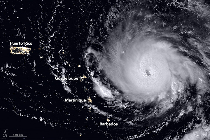
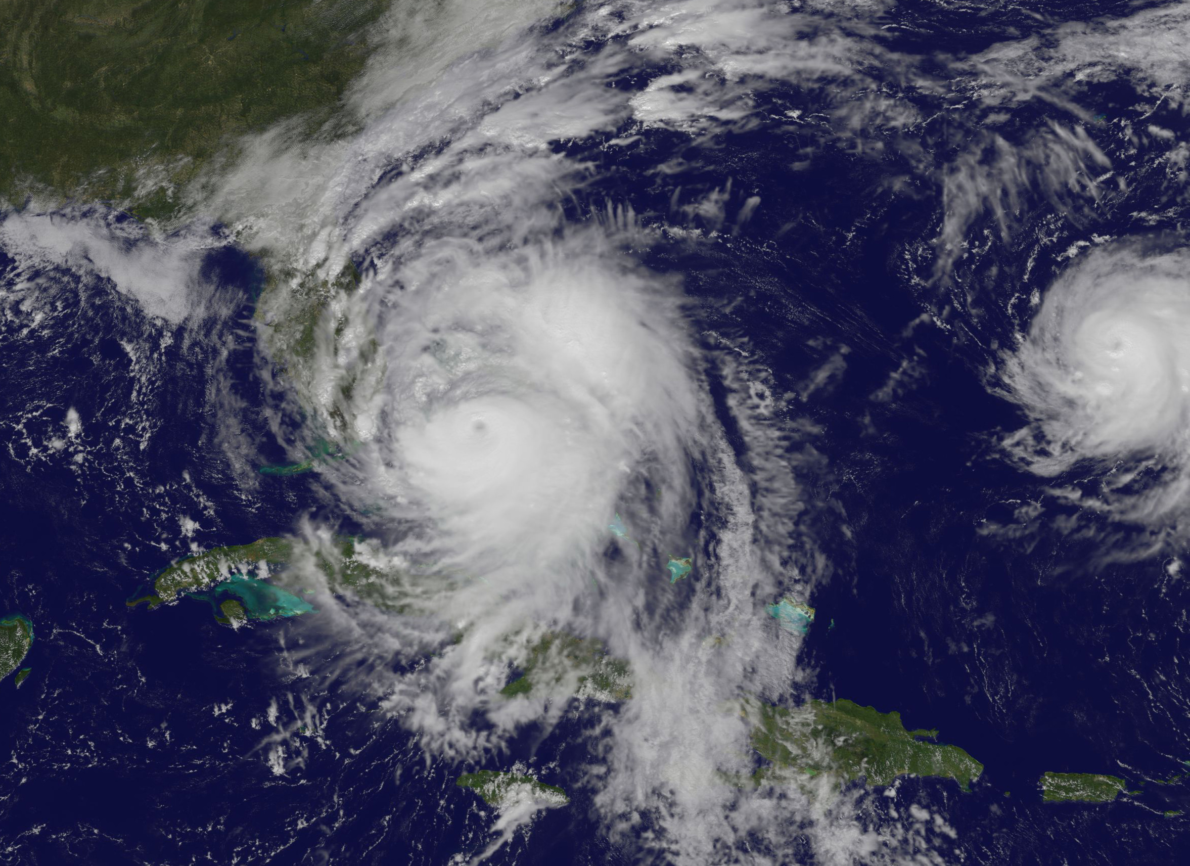
The Visible Infrared Imaging Radiometer Suite (VIIRS) on the Suomi NPP satellite captured this nighttime view of the Category 5 Hurricane Irma in the early hours of September 5, 2017. When the image was acquired, the storm’s center was moving due west. A National Hurricane Center forecast called for the hurricane to turn west-northwest toward the northern Leeward Islands. Credit: NASA, NOAA, Suomi NPP - VIIRS.
Record-setting Hurricane Irma barreled over the Caribbean islands of St. Martin, St. Barthelemy and Anguilla early Wednesday, destroying buildings with its sustained winds of 185 mph (297 kph), with rains and storm surges causing major flooding. The US National Hurricane Center listed the Category 5 Irma as the strongest Atlantic hurricane ever recorded north of the Caribbean and east of the Gulf of Mexico. The storm continues to roar on a path toward the U.S. and British Virgin Islands, Puerto Rico and possibly Florida, or along the southeast coast of the US.
This animation of NOAA’s GOES East satellite imagery from Sept. 3 at 8:15 a.m. EDT (1215 UTC) to Sept. 6 ending at 8:15 a.m. EDT (1215 UTC) shows Category 5 Hurricane Irma as it moved west and track over St. Martin by 8 a.m. EDT on Sept. 6:
Different models have Irma traveling on slightly different paths and officials from all the areas that might possibly be hit are telling people to prepare and follow evacuation orders. National Hurricane Center scientist Eric Blake said via twitter that some models had the storm going one way, and some another. But he cautioned everyone in a potential path should take precautions. “Model trends can be quite misleading- could just change right back. It is all probabilistic at this point. It could still miss [one particular area]. But chances of an extreme event is rising.”
The fleet of Earth-observing satellites are providing incredible views of this monster storm, and even astronauts on board the International Space Station are capturing views:
The International Space Station’s external cameras captured a dramatic view of Hurricane Irma as it moved across the Atlantic Ocean Sept. 5. pic.twitter.com/mc61pt2G8O
GOES-16 view of #HurricaneIrma at 30-second intervals covering 5-hour period ending at 352 AM CDT (9/6), including its passage over Barbuda. pic.twitter.com/WL6l6klPKw
While satellite views provide the most comprehensive view of Irma’s potential track, there’s also a more ‘hands-on’ approach to getting data on hurricanes. NOAA hurricane hunter Nick Underwood posted this video while his plane flew into Hurricane Irma yesterday. The plane’s specialized instruments can take readings on the storm that forecasters can’t get anywhere else:
In the meantime, a launch is scheduled from Cape Canaveral on Thursday, September 7. SpaceX is hoping to launch the US Air Force’s X-37B reusable spaceplane, but current forecasts put only a 50% chance of weather suitable enough on Thursday, and only 40% on Friday. We’ll keep you posted.
For the latest satellite views, the Twitter accounts above are posting regular updates.
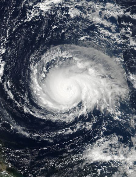
On Sept. 4 at 17:24 UTC, NASA-NOAA’s Suomi NPP satellite captured this view of Hurricane Irma as a Category 4 hurricane approaching the Leeward Islands. Credits: NOAA/NASA Goddard MODIS Rapid Response Team.
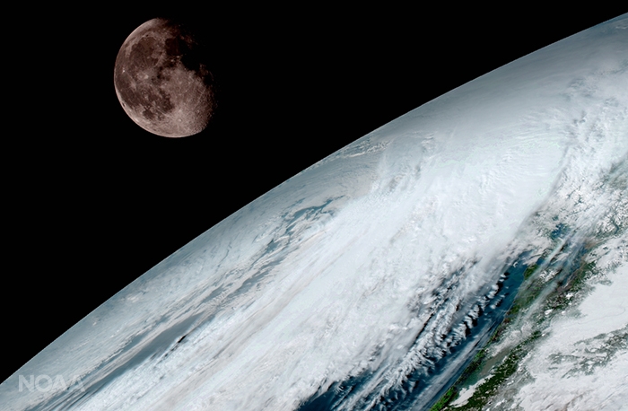
GOES-16 (previously known as GOES-R) captured this view of the moon as it looked across the surface of the Earth on January 15, 2017. Like earlier GOES satellites, GOES-16 will use the moon for calibration. Credit: NOAA/NASA
GOES-16 (previously known as GOES-R) captured this view of the moon as it looked across the surface of the Earth on January 15, 2017. Like earlier GOES satellites, GOES-16 will use the moon for calibration. Credit: NOAA/NASA
KENNEDY SPACE CENTER, FL – A new age has begun in the nations weather forecasting capabilities with the release today (Jan. 23) of the spectacular first images gathered by the recently launched NASA/NOAA GOES-16 observatory.
“It will be like high-definition from the heavens,” says NOAA.
“Today’s release of the first images from #GOES16 signals the start of a new age in satellite weather observation!!!”
Thus the newly obtained and published imagery has been anxiously awaited by scientists, meteorologists and ordinary weather enthusiasts.
“This is such an exciting day for NOAA! One of our GOES-16 scientists compared this to seeing a newborn baby’s first pictures — it’s that exciting for us,” said Stephen Volz Ph.D. director of NOAA’s Satellite and Information Service, in a statement.
“These images come from the most sophisticated technology ever flown in space to predict severe weather on Earth. The fantastically rich images provide us with our first glimpse of the impact GOES-16 will have on developing life-saving forecasts.”
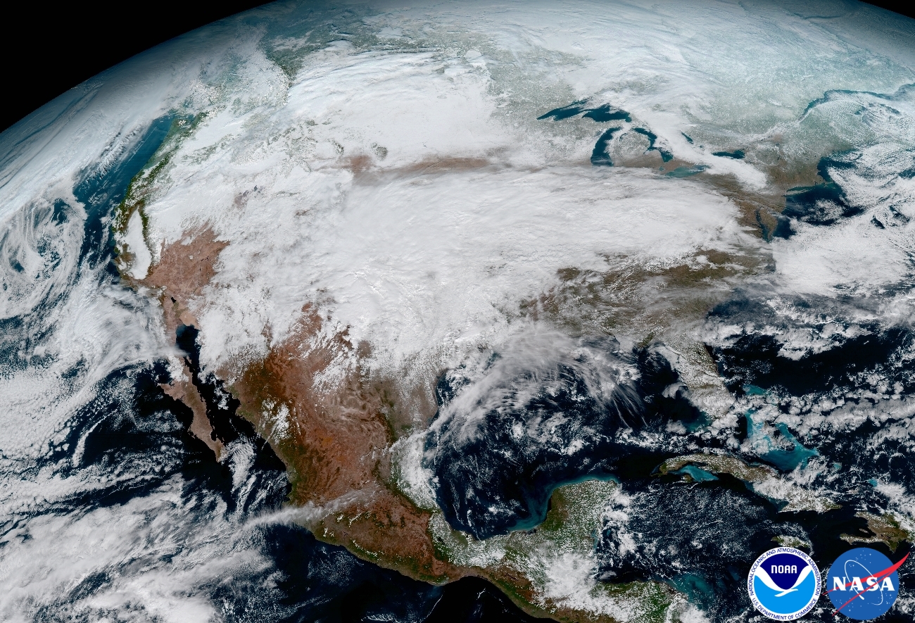
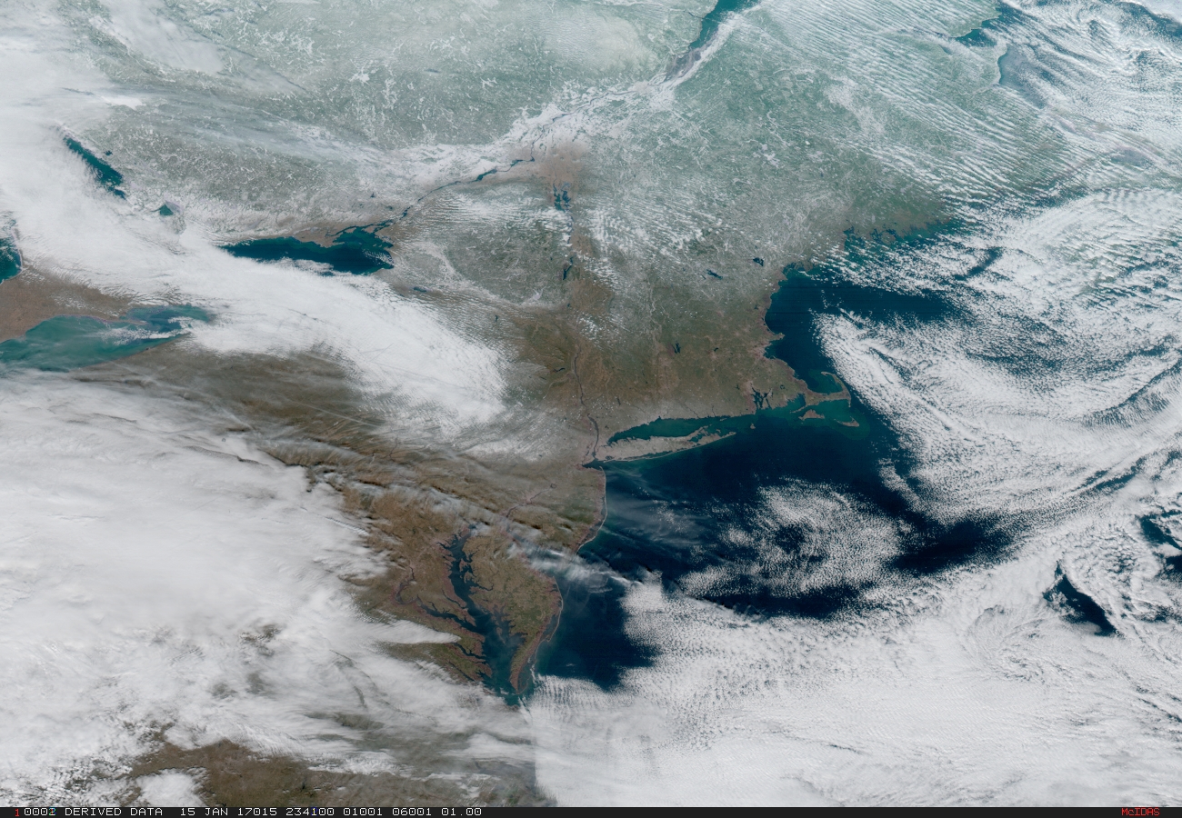
This image clearly shows the significant storm system that crossed North America that caused freezing and ice that resulted in dangerous conditions across the United States on January 15, 2017 resulting in loss of life. Credit: NOAA/NASA
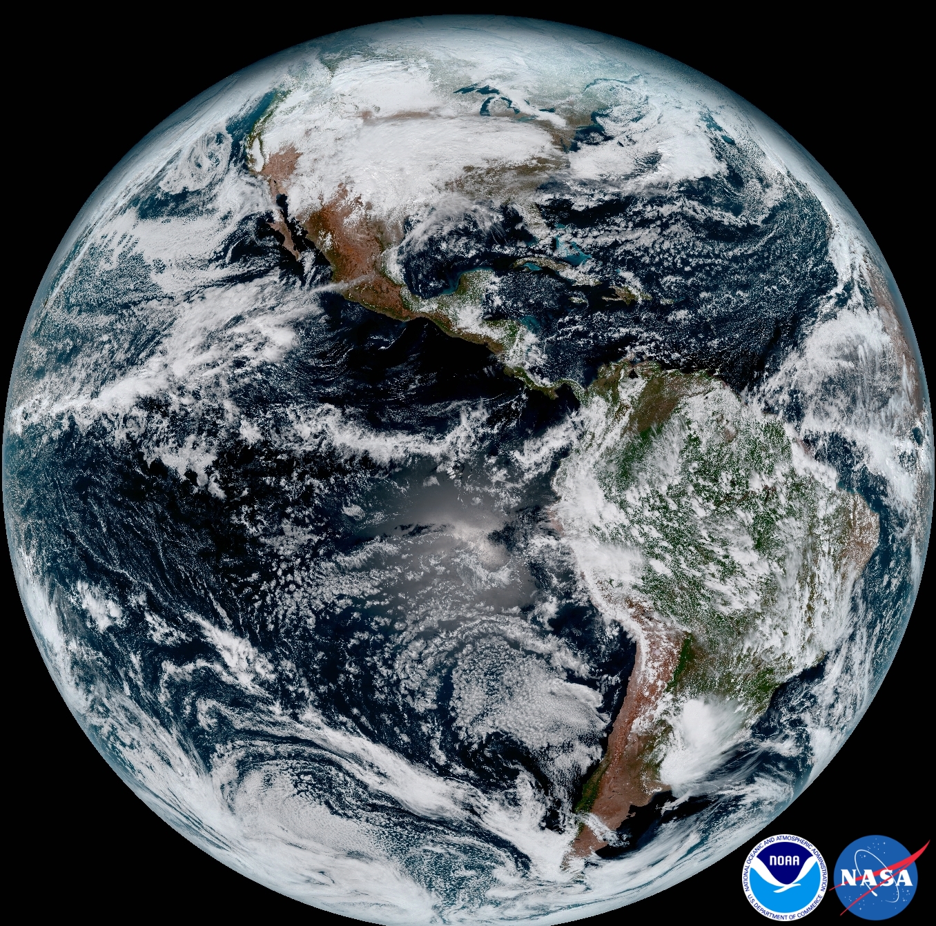
An especially eye-popping image taken by GOES -16 from its equatorial vantage point situated in geostationary orbit 22,300 miles (35,800 kilometers) above Earth and published today, shows both the Earth and the Moon together – as the lead image here.
The Earth/Moon combo shot is not only fantastically pleasing to the eye, but also serves a significant scientific purpose.
“Like earlier GOES satellites, GOES-16 will use the moon for calibration,” say NOAA officials.
“GOES-16 will boost the nation’s weather observation network and NOAA’s prediction capabilities, leading to more accurate and timely forecasts, watches and warnings.”
GOES-16 is the most advanced and powerful weather observatory ever built and will bring about a ‘quantum leap’ in weather forecasting.
“Seeing these first images from GOES-16 is a foundational moment for the team of scientists and engineers who worked to bring the satellite to launch and are now poised to explore new weather forecasting possibilities with this data and imagery,” said Volz.
“The incredibly sharp images are everything we hoped for based on our tests before launch. We look forward to exploiting these new images, along with our partners in the meteorology community, to make the most of this fantastic new satellite.”
It’s dramatic new imagery will show the weather in real time enabling critical life and property forecasting, help pinpoint evacuation zones and also save people’s lives in impacted areas of severe weather including hurricanes and tornadoes.
And the huge satellite can’t come online soon enough, as demonstrated by the severe winter weather and tornadoes that just wreaked havoc and death in various regions of the US.
Another breathtaking image product (seen below) produced by the GOES-16 Advanced Baseline Imager (ABI) instrument, built by Harris Corporation, shows a full-disc view of the Western Hemisphere in high detail — at four times the image resolution of existing GOES spacecraft.
This composite color full-disk visible image shows North and South America and was taken on January 15, 2017. It was created using several of the 16 spectral channels available on the GOES-16 Advanced Baseline Imager (ABI) instrument. Credit: NOAA/NASA
The 11,000 pound satellite was built by prime contractor Lockheed Martin and is the first of a quartet of four identical satellites – comprising GOES-R, S, T, and U – at an overall cost of about $11 Billion. This will keep the GOES satellite system operational through 2036.
This next generation of GOES satellites will replace the currently operating GOES East and GOES West satellites.
NOAA will soon decide whether GOES-16 will replace either the East or West satellites. A decision from NOAA is expected in May. GOES-16 will be operational by November 2017 as either the GOES-East or GOES-West satellite. Of course everyone wants it first.
The next satellite is nearing assembly completion and will undergo about a year of rigorous environmental and acoustic testing before launch. It will go to whichever slot was not selected this year.
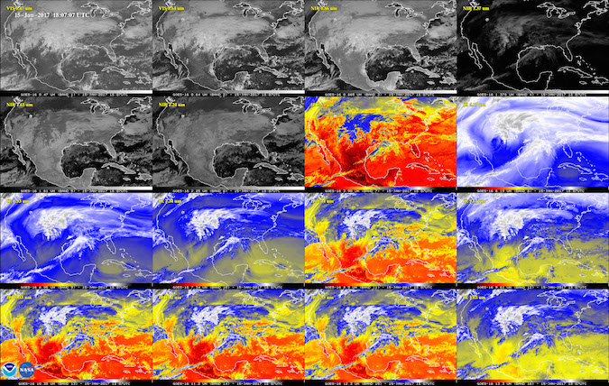
This 16-panel image shows the continental United States in the two visible, four near-infrared and 10 infrared channels on the Advanced Baseline Imager (ABI). These channels help forecasters distinguish between differences in the atmosphere like clouds, water vapor, smoke, ice and volcanic ash. Credit: NOAA/NASA
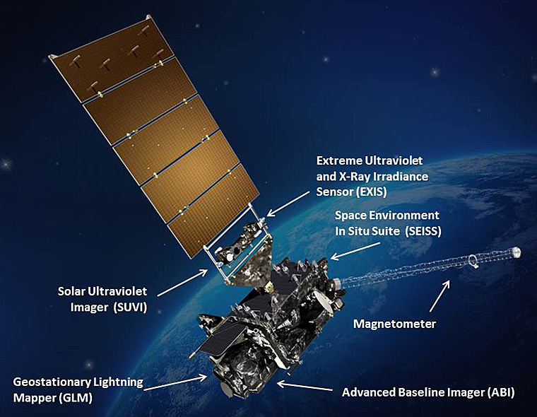
The six instrument science suite includes the Advanced Baseline Imager (ABI) built by Harris Corporation, the Geostationary Lightning Mapper (GLM) built by Lockheed Martin, Solar Ultraviolet Imager (SUVI), Extreme Ultraviolet and X-Ray Irradiance Sensors (EXIS), Space Environment In-Situ Suite (SEISS), and the Magnetometer (MAG).
ABI is the primary instrument and will collect 3 times more spectral data with 4 times greater resolution and scans 5 times faster than ever before – via the primary Advanced Baseline Imager (ABI) instrument – compared to the current GOES satellites.
Northeast Coast and New York Metropolitan region. On January 15, 2017 severe weather moved across the central United States before passing through the Northeast on the 16th and 17th where it resulted in wet and wintry weather for travelers across the region. Credit: NOAA/NASA
“The higher resolution will allow forecasters to pinpoint the location of severe weather with greater accuracy. GOES-16 can provide a full image of Earth every 15 minutes and one of the continental U.S. every five minutes, and scans the Earth at five times the speed of NOAA’s current GOES imagers.”
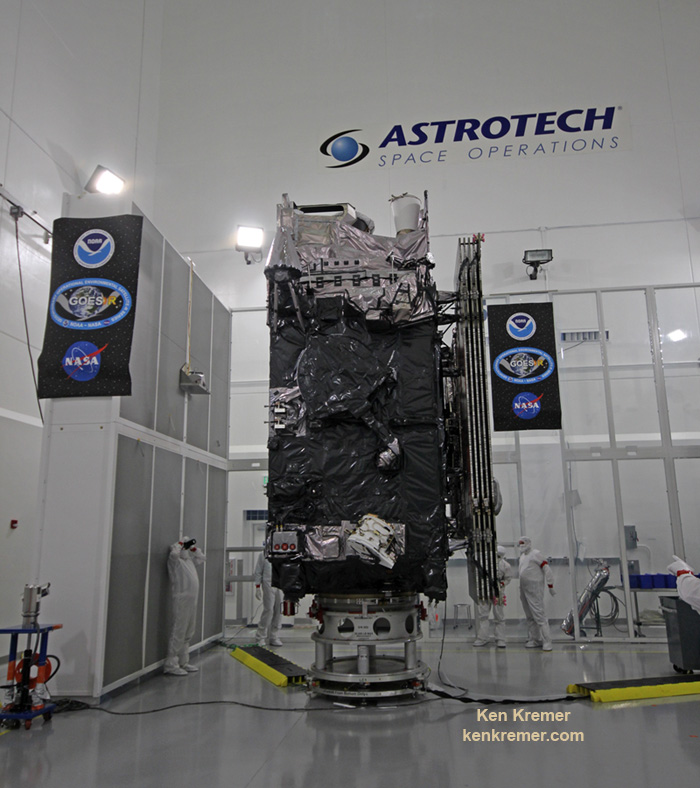
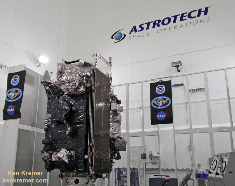
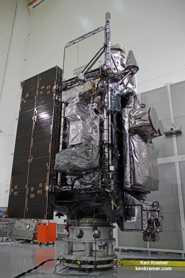
The NASA/NOAA GOES-R (Geostationary Operational Environmental Satellite – R Series) being processed at Astrotech Space Operations, in Titusville, FL, in advance of successful launch on a ULA Atlas V on Nov. 19, 2016. GOES-R/GOES-16 will be America’s most advanced weather satellite. Credit: Ken Kremer/kenkremer.com
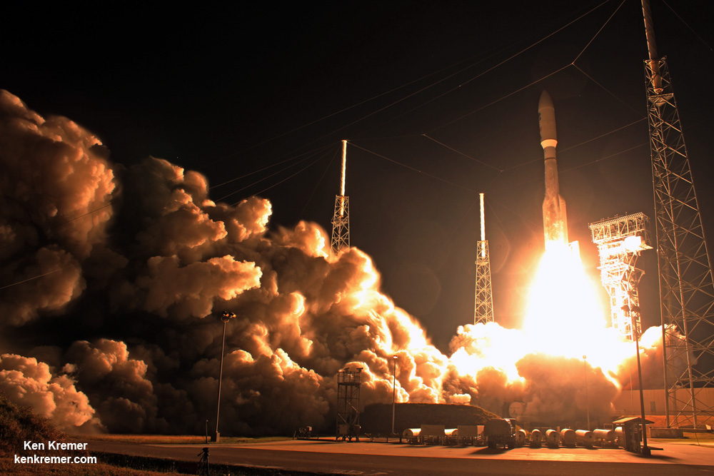
Blastoff of revolutionary NASA/NOAA GOES-R (Geostationary Operational Environmental Satellite – R Series) on ULA Atlas V from Space Launch Complex 41 (SLC-41) on Cape Canaveral Air Force Station, Florida on Nov. 19, 2016. GOES-R will deliver a quantum leap in America’s weather forecasting capabilities. Credit: Ken Kremer/kenkremer.com
Stay tuned here for Ken’s continuing Earth and Planetary science and human spaceflight news.
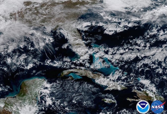
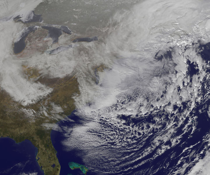
Ken Kremer Florida and The Caribbean. In May 2017, NOAA will announce the planned location for GOES-16. By November 2017, GOES-16 will be operational as either the GOES-East or GOES-West satellite. At its current check out location the satellite captured this image of the Caribbean and Florida. Here the satellite captures the shallows waters of the Caribbean. Credit: NOAA/NASA
The NASA/NOAA GOES-R (Geostationary Operational Environmental Satellite - R Series) being processed at Astrotech Space Operations, in Titusville, FL, in advance of launch on a ULA Atlas V on Nov. 19, 2016. GOES-R will be America’s most advanced weather satellite. Credit: Ken Kremer/kenkremer.com
The NASA/NOAA GOES-R (Geostationary Operational Environmental Satellite – R Series) being processed at Astrotech Space Operations, in Titusville, FL, in advance of planned launch on a ULA Atlas V slated for Nov. 19, 2016. GOES-R will be America’s most advanced weather satellite. Credit: Ken Kremer/kenkremer.com
KENNEDY SPACE CENTER, FL – After an ironic detour due to Hurricane Matthew, liftoff of the game changing NASA/NOAA next generation GOES-R geostationary weather observation satellite offering a “dramatic leap in capability” is finally on track for this weekend on Nov. 19 from the Florida Space Coast.
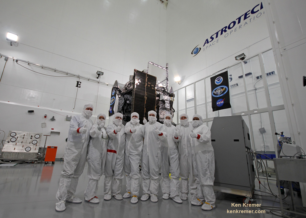
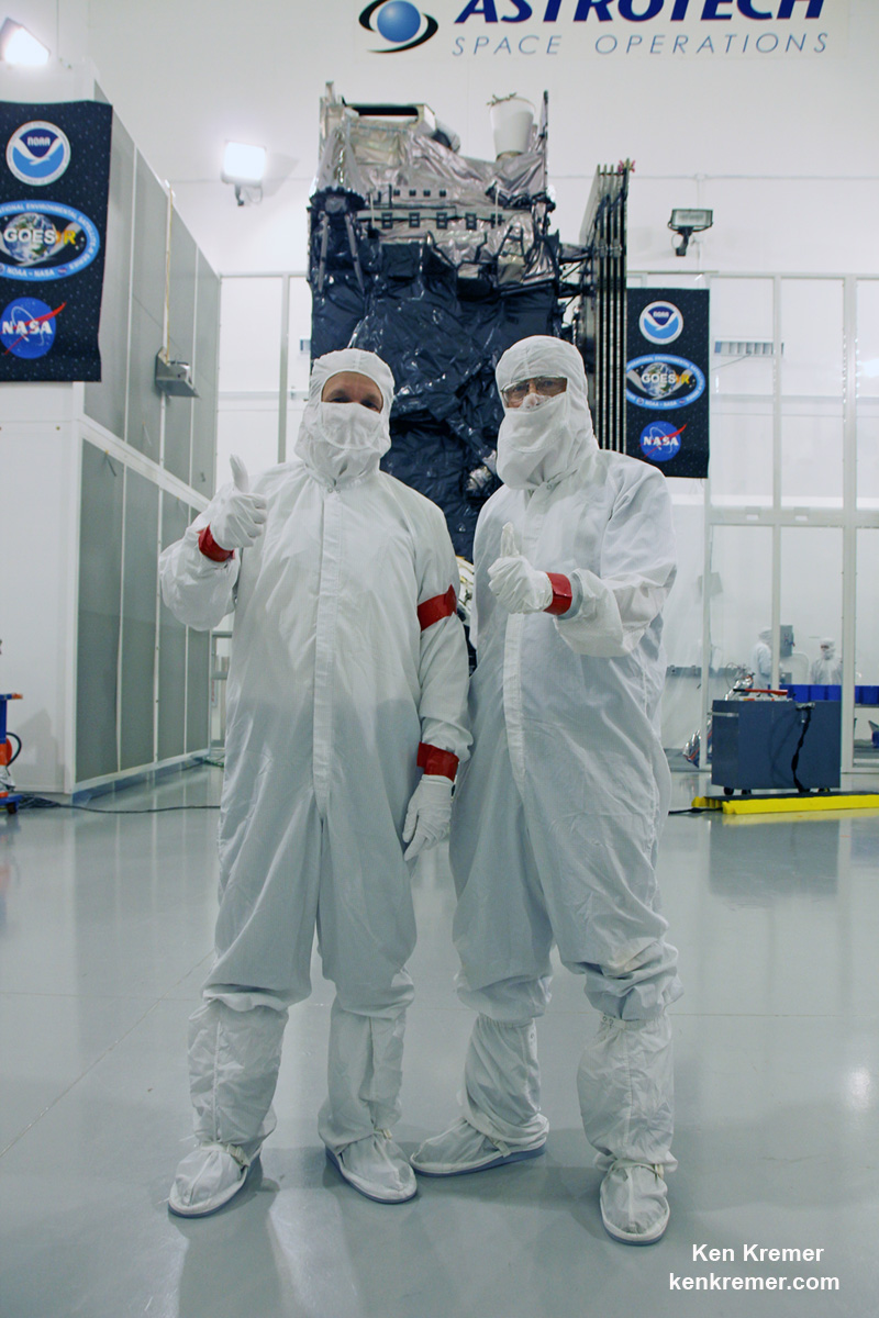
And Universe Today recently got an up close look and briefing about the massive probe inside the cleanroom processing facility at Astrotech Space Operations in Titusville, Fl.
“We are bringing the nation a new capability .. that’s a dramatic leap .. to scan the entire hemisphere in about 5 minutes,” said Greg Mandt, NOAA GOES-R program manager during a briefing in the Astrotech cleanroom.
“GOES-R has both weather and space weather detection capabilities!” Tim Gasparrini, GOES-R program manager for Lockheed Martin, told Universe Today during a cleanroom interview.
Astrotech is located just a few miles down the road from NASA’s Kennedy Space Center and the KSC Visitor Complex housing the finest exhibits of numerous spaceships, hardware items and space artifacts.
The NASA/NOAA GOES-R (Geostationary Operational Environmental Satellite – R Series) being processed at Astrotech Space Operations, in Titusville, FL, in advance of planned launch on a ULA Atlas V slated for Nov. 19, 2016. GOES-R will be America’s most advanced weather satellite. Credit: Ken Kremer/kenkremer.com
GOES-R, which stands for Geostationary Operational Environmental Satellite – R Series – is a new and advanced transformational weather satellite that will vastly enhance the quality, speed and accuracy of weather forecasting available to forecasters for Earth’s Western Hemisphere.
Liftoff of the NASA/NOAA GOES-R weather satellite atop a United Launch Alliance (ULA) Atlas V rocket is now scheduled for Saturday, Nov. 19 at 5:42 p.m. from Space Launch Complex 41 (SLC-41) on Cape Canaveral Air Force Station, shortly after sunset.
The launch window extends for an hour from 5:42-6:42 p.m. EST.
GOES-R is the first in a new series of American’s most powerful and most advanced next generation weather observation satellites. It is designed to last for a 15 year orbital lifetime.
Once in orbit it will be known as GOES-16. TV viewers are presently accustomed to seeing daily streams of imagery from the GOES-East and GOES-West weather observation satellites currently in orbit.
What’s the big deal about GOES-R?
Audiences will notice big changes from GOES-R once it becomes operational because it will provide images of weather patterns and severe storms as regularly as every five minutes or as frequently as every 30 seconds.
“These images can be used to aid in weather forecasts, severe weather outlooks, watches and warnings, lightning conditions, maritime forecasts and aviation forecasts.
“It also will assist in longer term forecasting, such as in seasonal predictions and drought outlooks. In addition, space weather conditions will be monitored constantly, including the effects of solar flares to provide advance notice of potential communication and navigation disruptions. It also will assist researchers in understanding the interactions between land, oceans, the atmosphere and climate.”
GOES-R was built by prime contractor Lockheed Martin and is the first of a four satellite series – comprising GOES-R, S, T, and U that will be keep the GOES satellite system operational through 2036.
All four of the revolutionary 11,000 pound satellites are identical. The overall cost is about $11 Billion.
“This is a very exciting time,” explained Greg Mandt, the NOAA GOES-R program manager during the Astrotech cleanroom briefing.
“This is the culmination of about 15 years of intense work for the great team of NOAA and NASA and our contractors Lockheed Martin and Harris.”
“We are bringing the nation a new capability. The GOES program has been around for about 40 years and most every American sees it every night on the weather broadcasts when they see go to the satellite imagery. And what’s really exciting is that for the first time in that 40 years we are really end to end replacing the entire GOES system. The weather community is really excited about what we are bringing.”
“It’s a dramatic leap in capability – like moving from black and white TV to HDTV.”
“We will be able to scan the entire hemisphere in about 5 minutes and do things so much faster with double the resolution.”
The NASA/NOAA/Lockheed Martin/Harris GOES-R team gives a big thumbs up for the dramatic leap in capability this next gen weather observation satellite will provide – during media briefing at Astrotech Space Operations, in Titusville, FL. Launch is set for Nov. 19, 2016. Credit: Ken Kremer/kenkremer.com
It was built in facilities in Bucks County, Pennsylvania and Denver, Colorado. It arrived at Astrotech in August for final processing and checkouts of the spacecraft and instruments.
The gigantic school bus sized satellite is equipped with a suite of six instruments or sensors that are the most advanced of their kind. They will be used for three types of observations: Earth sensing, solar imaging, and space environment measuring. They will point to the Earth, the Sun and the in-situ environment of the spacecraft.
The suite includes the Advanced Baseline Imager (ABI), Geostationary Lightning Mapper (GLM), Solar Ultraviolet Imager (SUVI), Extreme Ultraviolet and X-Ray Irradiance Sensors (EXIS), Space Environment In-Situ Suite (SEISS), and the Magnetometer (MAG).
The two Earth-pointing instruments are on the top of the spacecraft – namely ABI and GLM.
“ABI is the premier instrument on the spacecraft. When you turn on the news and see a severe storm picture, that’s the one it comes from. It takes pictures in the visible as well as the infrared (IR), near infrared (IR),” Tim Gasparrini, GOES-R program manager for Lockheed Martin, told Universe Today during a cleanroom interview.
“It is looking for things like moisture, vegetation, aerosols and fire. So it looks across a broad spectrum to determine the environmental conditions on Earth.”
ABI offers 3 times more spectral channels with 4 times greater resolution and scans 5 times faster than ever before, compared to the current GOES satellites.
The GOES-R ABI will view the Earth with 16 different spectral bands (compared to five on current GOES), including two visible channels, four near-infrared channels, and ten infrared channels, according to the mission fact sheet.
It will also carry the first operational lightning mapper ever flown in space – GLM – built by Lockheed Martin. It has a single-channel, near-infrared optical transient detector.
“This is the first lightning mapper in space and at geostationary orbit.”
“GLM takes a picture of a scene on the Earth 500 times per second. And it compares those images for a change in the scene that can detect lightning, using an algorithm,” Gasparrini told me.
“The importance of that is lightning is a precursor to severe weather. So they are hoping that GLM will up to double the tornado warning time. So instead of 10 minutes warning you get 20 minutes warning, for example.”
GLM will measure total lightning (in-cloud, cloud-to-cloud and cloud-to-ground) activity continuously over the Americas and adjacent ocean regions with near-uniform spatial resolution of approximately 10 km.
Side view of NASA/NOAA GOES-R next gen weather observation satellite showing solar panels and instruments inside Astrotech Space Operations cleanroom, in Titusville, FL. Launch is set for Nov. 19, 2016. Credit: Ken Kremer/kenkremer.com
“The two solar pointing instruments are located on a platform that constantly points them at the sun – SUVI (built by Lockheed Martin and EXIS. SUVI looks at the sun in the ultraviolet and EXIS looks at the x-ray wavelengths.”
The instruments work in concert.
“SUVI detects a solar flare on he sun and EXIS measures the intensity of the flare. As it comes towards the Earth, NOAA then uses the DSCOVR satellite [launched last year] as sort of a warning buoy about 30 minutes before the Earth. This gives a warning that a geomagnetic storm is heading toward the Earth.”
“When the storm reaches the Earth, the magnetometer instrument (MAG) on GOES-R then measures the influence of the magnetic storm on the magnetic field of the Earth.”
“Then the SEISS instrument, a charged particle detector, measures the charged particle effect of the storm on the Earth at geostationary orbit.”
“So GOES-R has both weather and space weather detection capabilities!” Gasparini elaborated.
The huge bus sized satellite measures 6.1 m x 5.6 m x 3.9 m (20.0 ft x 18.4 ft x 12.8 ft) with a three-axis stabilized spacecraft bus.
It has a dry mass of 2,857 kg (6,299 lbs) and a fueled mass of 5,192 kg (11,446 lbs) at launch.
The instruments are very sensitive to contamination and the team is taking great care to limit particulate and molecular contaminants in the cleanroom. Some of the instruments have contamination budget limits of less than 10 angstroms – smaller than the diameter of a typical molecule. So there can’t even be a single layer of molecules on the instruments surface after 15 years on orbit.
GOES-R can also multitask according to a NASA/NOAA factsheet.
“It can scan the Western Hemisphere every 15 minutes, the Continental U.S. every 5 minutes and areas of severe weather every 30-60 seconds. All at the same time!”
GOES-R will blastoff on a ULA Atlas V in the very powerful 541 configuration, augmented by four solid rocket boosters on the first stage. The payload fairing is 5 meters (16.4 feet) in diameter and the upper stage is powered by a single-engine Centaur.
It will be launched to a Geostationary orbit some 22,300 miles above Earth.
The Atlas V booster has been assembled inside the Vertical Integration Facility (VIF) at SLC-41 and will be rolled out to the launch pad Friday morning, Nov. 18 with the GOES-R weather satellite encapsulated inside the nose cone.
The weather forecast shows a 80 percent chance of favorable weather conditions for Saturday’s sunset blastoff.
GOES-R logo. Credit: NASA/NOAA
Stay tuned here for Ken’s continuing Earth and Planetary science and human spaceflight news.
Learn more about GOES-R weather satellite, Heroes and Legends at KSCVC, OSIRIS-REx, InSight Mars lander, ULA, SpaceX and Orbital ATK missions, Juno at Jupiter, SpaceX AMOS-6 & CRS-9 rocket launch, ISS, ULA Atlas and Delta rockets, Orbital ATK Cygnus, Boeing, Space Taxis, Mars rovers, Orion, SLS, Antares, NASA missions and more at Ken’s upcoming outreach events:
Nov 17-20: “GOES-R weather satellite launch, OSIRIS-Rex, SpaceX and Orbital ATK missions to the ISS, Juno at Jupiter, ULA Delta 4 Heavy spy satellite, SLS, Orion, Commercial crew, Curiosity explores Mars, Pluto and more,” Kennedy Space Center Quality Inn, Titusville, FL, evenings
GOES-R infographicTim Gasparinni, GOES-R program manager for Lockheed Martin, and Ken Kremer/University Today pose with GOES-R revolutionary weather satellite inside Astrotech Space Operations cleanroom, in Titusville, FL, and built by NASA/NOAA/Lockheed Martin/Harris. Credit: Ken Kremer/kenkremer.com
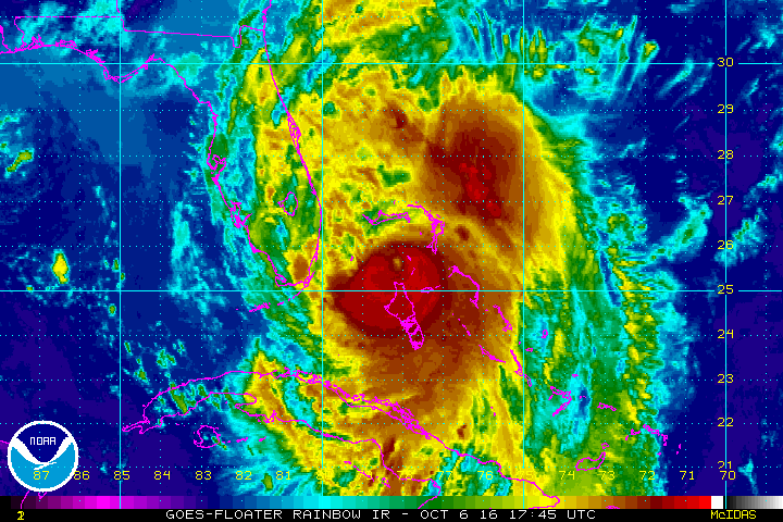
Cat 4 Hurricane Matthew track during the late evening of 6 Oct 2016. Credit: NASA/NOAA
Cat 4 Hurricane Matthew track during the late evening of 6 Oct 2016. Credit: NASA/NOAA
The imminent impact of the already deadly Category 4 Hurricane Matthew along the Florida Space Coast tonight, Thursday, October 6, has forced the closure of NASA’s Kennedy Space Center (KSC) and mass evacuations along the US East coast from Florida, to Georgia to the Carolinas.
“Hurricane Matthew, currently an extremely dangerous Category 4 storm on the Saffir-Simpson Hurricane Wind Scale, continues to bear down on the southeastern United States,” says NASA in an update today.
NASA has closed KSC for today and tomorrow, at a minimum and the center has entered HurrCon 1 status.
“Under the current storm track, peak winds are forecast to be 125 mph sustained with gusts to 150 mph, however a shift in the track even slightly could improve the wind forecast somewhat,” wrote NASA’s Brian Dunbar.
“The Kennedy Space Center is closed today, Oct. 6, and Friday for Hurricane Matthew. Kennedy Space Center is now in HurrCon 1 status, meaning a hurricane is imminent.”
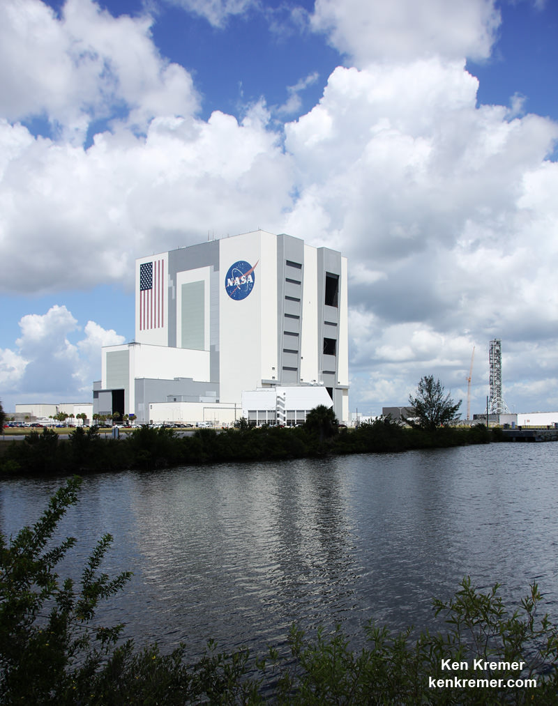
The Kennedy Space Center on Florida’s Space Coast is home to the iconic Vehicle Assembly Building (VAB) – the most well known building at NASA – as well as Launch Complex’s 39 A and B which launched American astronauts to Moon and thereafter Space Shuttles for three decades.
The launch pads sit precariously close to the Atlantic Ocean shoreline – just a few hundred yards (meters) away!
View of the VAB and Mobile Launcher from the KSC Launch Complex 39 Press Site. NASA is upgrading the VAB with new platforms to assemble and launch NASA’s Space Launch System rocket at the Kennedy Space Center in Florida. Credit: Ken Kremer/kenkremer.com
“Across the spaceport, essential personnel are preparing facilities for the storm’s arrival,” according to George Diller, NASA Kennedy Space Center Public Affairs Officer.
“Hurricane Matthew is expected to make its closest approach to the Cape Canaveral/Kennedy area overnight Thursday and into Friday morning, bringing with it the potential for heavy rain, storm surge and hurricane-force winds.”
The last time a major Hurricane impacted near KSC and the Space Coast was in 2004. The VAB suffered some outside damage.
Hurricane Matthew is bearing down on the US East Coast right now at Florida’s Peninsula and is tracking north.
This visible image on Oct. 6 at 1:00 p.m. EDT from NOAA’s GOES-East satellite shows Hurricane Matthew as it regained Category 4 Hurricane Status. Credits: NASA/NOAA GOES Project
Herein is the latest satellite imagery from NASA and NOAA of this evening.
Mass evacuations have been ordered and States of Emergencies declared by the Governors of Florida, Georgia and North and South Carolina.
The high winds, storm surge of potentially 5 to 11 feet, drenching rains and extensive flooding is expected to cause massive damage and devastation to homes, businesses and infrastructure.
Cat 4 Hurricane Matthew track during the late evening of 6 Oct 2016. Credit: NASA/NOAA
Hundreds of thousands of folks have left their home over the past 2 days. Many gas stations are dry and grocery store shelves emptied.
Matthew will cause a wide swath of destruction and potentially deaths along hundreds of miles of US shoreline and inland areas as the massive storm hugs the coast like none before in recorded history.
Furthermore, hundreds of thousands of folks are expected to lose power as well, for days and perhaps weeks.
Hundreds of deaths and massive destruction in Haiti, Cuba and elsewhere in the Caribbean can already be blamed on Hurricane Matthew – a storm like none other and by far the worst since Superstorm Sandy and Hurricane Katrina.
After the storm passes KSC will evaluate all its facilities.
“Once the storm has passed, center facilities and infrastructure will be assessed and employees will be cleared to return when it is safe to do so,” Diller.
Indeed NASA was preparing to launch America’s newest and most advanced weather satellite on Nov 4. It’s named GOES-R and was slated for blastoff from Cape Canaveral Air Force Station atop a ULA Atlas V on Nov. 4.
The launch facilities will have to be thoroughly inspected before the launch can proceed.
The satellite is in the final stages of preparation at the Astrotech Space Operations Facility in Titusville, FL as I recently observed during an up close visit in the High Bay cleanroom.
Titusville and Astrotech could suffer a direct hit from Matthew. But the satellite has been secured.
The NASA/NOAA GOES-R (Geostationary Operational Environmental Satellite – R Series) being processed at Astrotech Space Operations, in Titusville, FL, in advance of the planned launch on a ULS Atlas V on Nov 4, 2016. GOES-R will be America’s most advanced weather satellite. Credit: Ken Kremer/kenkremer.com
Here is the latest Advisory from the National Hurricane Center (NHC) as of 8 PM EDT Oct 6.
At 800 PM EDT (0000 UTC), the eye of Hurricane Matthew was located over the western end of Grand Bahama Island near latitude 26.6 North, longitude 78.9 West. The hurricane is moving toward the northwest near 13 mph (20 km/h), and this general motion is expected to continue tonight with a turn toward the north-northwest early Friday. On the forecast track, the eye of Matthew should move away from Grand Bahama Island during the next few hours, and move close to or over the east coast of the Florida peninsula through Friday night.
Reports from a NOAA Hurricane Hunter aircraft indicate that maximum sustained winds are now near 130 mph (210 km/h) with higher gusts. Matthew is a category 4 hurricane on the Saffir-Simpson Hurricane Wind Scale. Some fluctuations in intensity are likely while the hurricane moves toward the coast of Florida.
Hurricane-force winds extend outward up to 60 miles (95 km) from the center and tropical-storm-force winds extend outward up to 185 miles (295 km). Settlement Point in the Bahamas recently reported a sustained wind of 79 mph (128 km/h) with a gust of 105 mph (169 km/hr). The Lake Worth Pier near Palm Beach, Florida, recently reported a sustained wind of 46 mph (74 km/h) and a wind gust of 60 mph (96 km/h).
The minimum central pressure estimated from NOAA Hurricane Hunter data is 939 mb (27.73 inches).
…….
The latest weather briefing indicates that “tropical storm force winds beginning at Cape Canaveral tonight at midnight with hurricane force winds starting at about 6 a.m.
A hurricane ride-out crew of 116 has arrived at KSC this evening to prepare for Matthew.
“All facilities at Kennedy Space Center and Cape Canaveral Air Force Station have been secured.”
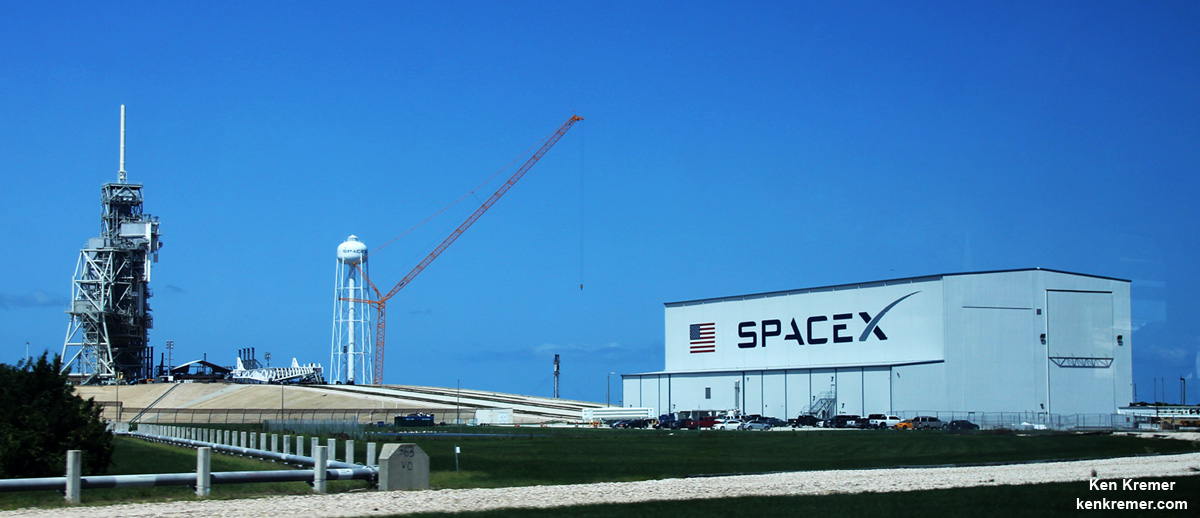
SpaceX is currently renovating and refurbishing pad 39A to launch their commercial Falcon 9 and Falcon Heavy rockets as well the Crew Dragon with astronauts on mission to the ISS.
The eye of the storm is barreling towards KSC at this moment. Stay tuned for the outcome.
SpaceX is renovating Launch Complex 39A at the Kennedy Space Center for launches of the Falcon Heavy and human rated Falcon 9. Credit: Ken Kremer/kenkremer.com
Stay tuned here for Ken’s continuing Earth and Planetary science and human spaceflight news.
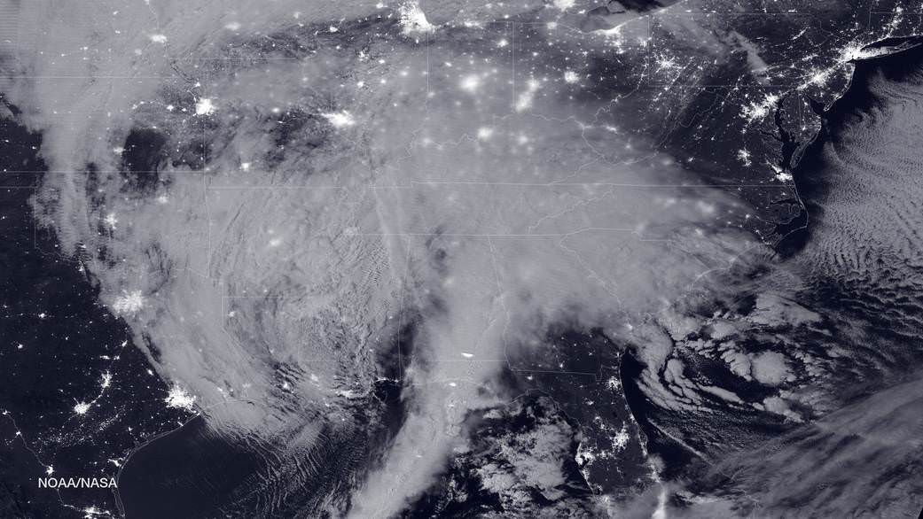
NASA-NOAA's Suomi NPP satellite snapped this image of the approaching blizzard around 2:35 a.m. EST on Jan. 22, 2016 using the Visible Infrared Imaging Radiometer Suite (VIIRS) instrument's Day-Night band. Credit: NOAA/NASA
NASA-NOAA’s Suomi NPP satellite snapped this image of the approaching blizzard around 2:35 a.m. EST on Jan. 22, 2016 using the Visible Infrared Imaging Radiometer Suite (VIIRS) instrument’s Day-Night band. Credit: NOAA/NASA
NEW JERSEY- The monstrous ‘Blizzard of 2016’ predicted by weather forecasters for days has struck a wide swath of the US East Coast from the Gulf coast to the Carolinas to New York and soon into New England, with full fury today, Friday, Jan. 22.
NASA and NOAA satellites are tracking the storm which is already inundating the biggest population centers, affecting some 85 million people in 20 states up and down the Atlantic Coast, as it moves in a northeasterly direction.
This afternoon, NASA and NOAA released a series of eyepopping satellite images showing the massive extent of the storm, which may drop historic amounts of snow on Washington DC and other cities over the next 24 to 48 hours.
The two agencies released a particularly striking image, shown above, showing the storm swarming over virtually the entire eastern half of the continental US as it was barreling towards the East coast cites.
It was taken Friday afternoon by the NASA-NOAA’s Suomi NPP satellite showing the approaching blizzard around 2:35 a.m. EST on Jan. 22, 2016 using the Visible Infrared Imaging Radiometer Suite (VIIRS) instrument’s Day-Night band.
States of Emergency have been declared by Governors of states from the mid-Atlantic to New England, including North Carolina, Virginia, Maryland, New York, Pennsylvania, New Jersey, Kentucky, Georgia, Tennessee, West Virginia, the District of Columbia and the list is growing.
The heaviest snowfall is expected in and around Washington DC with estimates of 24 inches of snow or more. 18 to 24 inches may fall along the metropolitan Northeast corridor on Baltimore, Philadelphia, Trenton and New York City.
This visible image from NOAA’s GOES-East satellite at 1830 UTC (1:30 p.m. EST) on Jan. 22, 2016 shows the major winter storm now affecting the U.S. East coast. Credits: NASA/NOAA GOES Project
The heavy, blinding snow was already hitting Virginia and Washington by Friday afternoon. Governors, Mayors and Federal officials warned drivers to get off the roads by early Friday afternoon.
Stay off the roadways !!
Widespread treacherous driving with icy roads, sleet, rain, low visibility and whiteout conditions are causing numerous auto accidents as the blizzard bashes the region.
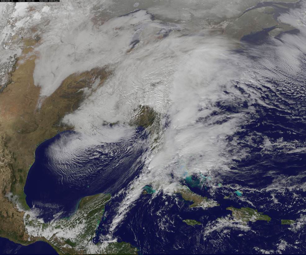
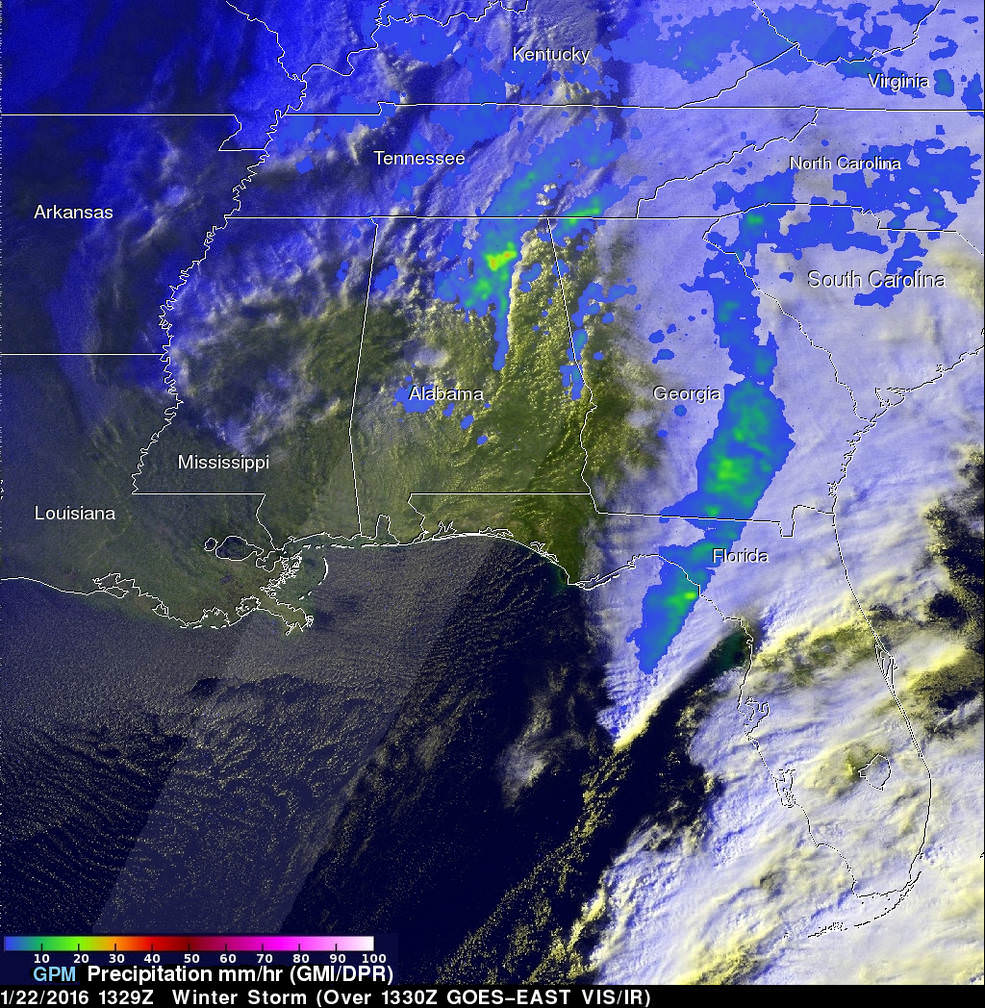
“The winter storm that caused damage during the night along the Gulf Coast has deepened and has started to spread heavy rain, freezing rain, sleet and snow northward into the Mid-Atlantic region. NASA’s GPM and NOAA’s GOES satellites are providing data on rainfall, cloud heights, extent and movement of the storm” wrote NASA’s Rob Gutro in an update on Friday.
On January 22 at 1329 UTC (8:29 a.m. EST) the GPM core satellite saw precipitation falling at a rate of over 64 mm (2.5 inches) per hour in storms over northern Alabama. Credits: SSAI/NASA/JAXA, Hal Pierce
The National Weather Service (NWS) Weather Prediction Center in College Park, Maryland said “An area of low pressure centered over the southeastern U.S. will continue developing into a major winter storm which will impact a large portion of the East Coast from the southern Appalachians through the Mid-Atlantic States from Friday into the weekend. Snowfall totals may exceed 2 feet in portions of these areas, including the Baltimore and Washington D.C. metropolitan areas.”
The monster storm has already caused at least ten deaths. Thousands of motorists are stranded.
High winds up to 55 mph are expected to batter the New Jersey shore, causing significant beach erosion, coastal flooding and property destruction in the same areas devastated by Superstorm Sandy. Thousands of people have been evacuated.
The blizzard has also impacted the US Presidential campaigns and forced New Jersey Governor Chris Christie to temporary cancel campaign appearances in New Hampshire on Friday and Saturday, to deal first hand with the storm back home.
Heavy ice and snow accumulations could cause falling tress resulting in downed power lines and days long power outages during brutally cold temperatures.
Here’s a cool supercomputer animation model:
Video caption: A NASA Center for Climate Simulation supercomputer model that shows the flow of #Blizzard2016 thru Sunday, January 24, 2015. Credit: NASA
Many airports have been closed and some seven thousand flights have also been canceled.
The storm is expected to last into Sunday, Jan. 24
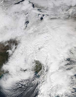
Looking massive from space…. This view of the winter storm over the eastern United States was captured on Friday, January 22, 2016 at 1:55 pm ET via the Visible Infrared Imaging Radiometer Suite (VIIRS) instrument on the Suomi NPP satellite. Credit: NASA/Goddard/Suomi NPP/VIIRS
Stay tuned here for Ken’s continuing Earth and Planetary science and human spaceflight news.
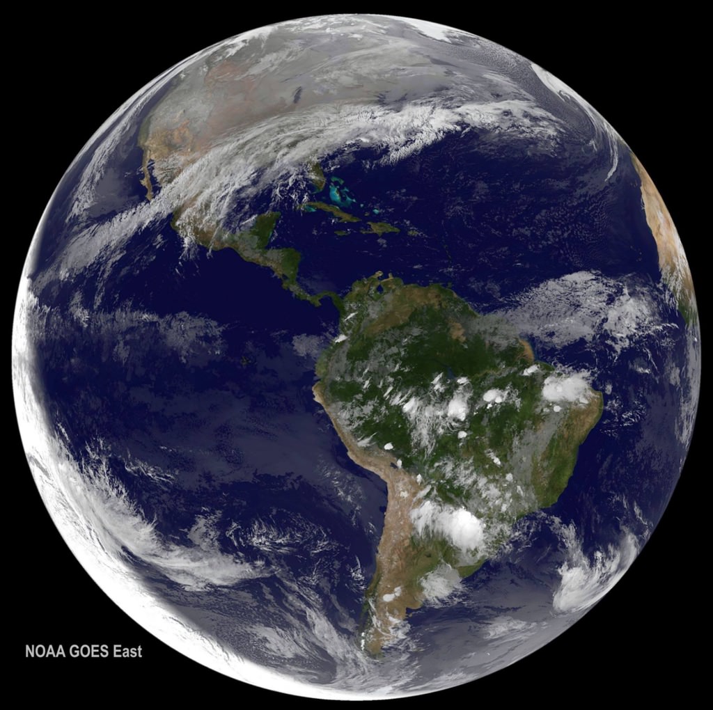
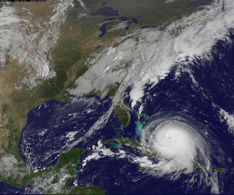
NOAA's GOES-East satellite captured this visible image of Hurricane Joaquin affecting the Bahamas on Thursday, Oct. 1 at 1255 UTC. Credits: NASA/NOAA GOES Project
Video caption: This animation of images captured from September 29 to October 1, 2015 from NOAA’s GOES-East satellite shows Hurricane Joaquin become a major hurricane in the Bahamas. Credits: NASA/NOAA GOES Project
NEW JERSEY – A wide swath of the US East Coast is bracing for impact in the coming days as ‘Hurricane Joaquin’ strengthened to a major and dangerous Category 4 storm, today, Thursday, Oct. 1, as NASA and NOAA satellites keep constant watch as it barrels potentially towards tens of millions of coastal residents.
Joaquin is already packing winds exceeding 130 mph with even higher wind gusts as the storm continues to strengthen at this hour and the pressure is decreasing. See the latest Hurricane Joaquin animation and imagery from NASA and NOAA, above and below.
A ULA Atlas V is slated to lift off Friday from Cape Canaveral Air Force Station in Florida at 6:08 a.m. EDT with the Morelos-3 communications satellite for Mexico, before the hurricane gets closer to Florida.
The National Hurricane Center declared Joaquin had intensified into a massive Category 4 hurricane on the Saffir-Simpson Wind Scale, as of 2 PM EDT today, Oct. 1.
You can watch the launch on ULA’s live webcast starting at 5:48 a.m. Oct 2: http://www.ulalaunch.com
The governors of three states – New Jersey, Virginia and North Carolina – have already declared ‘States of Emergency’ in anticipation of potentially destructive winds, potentially life threatening drenching rains and floods, downed power lines and ocean rip currents with high waves in local areas.
Multiple NASA and NOAA satellites are intensively and continuously observing Joaquin, and are providing absolutely critical data to forecasters and government officials with the most current and best information available.
NASA’s GPM, Terra and NPP-Suomi satellites and NOAA’s GOES-East satellite are tracking Joaquin and have seen powerful thunderstorms today which indicates continued strengthening.
At this time we still don’t whether the US eastern seaboard will suffer a major hit but officials are taking no chances after suffering through Superstorm Sandy which caused many deaths, widespread power outages and billions and billions of dollars of damage – from which we are still recovering.
Joaquin is currently over The Bahamas in the Caribbean and is expected to make a sharp right turn on Friday Oct 2 and head northwards to the east coast and the Atlantic Ocean. It could start impacting the Carolinas and regions further north as soon as Sunday, Oct. 4, based on current forecasts, and drop double digits inches of torrential rainfall.
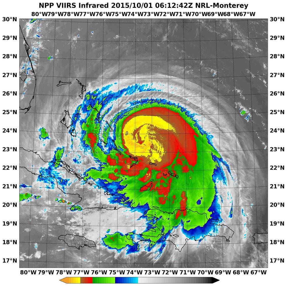
NASA-NOAA’s Suomi NPP satellite passed over Joaquin at 06:10 UTC (2:10 a.m. EDT) on Oct. 1 as it was strengthening from a Category 2 to a Category 3 hurricane. It’s now a Category 4. Imagery showed cloud top temperatures colder than -63F/-53C (yellow). Credits: NRL/NASA/NOAA
Its pounding the Bahamas right now and is creating a disaster with hurricane force winds and heavy rainfall, say weather forecasters, as it remains over the island for some 24 hours or more and may drop over 10 inches of rain.
But there is a very wide cone of uncertainly of where it could hit as the possible storm track extends from the Carolinas to Maine. It may or may not directly impact the eastern US. The storm may shift to the right and spare the east coast. But no one knows at this time.
Some areas on the US East coast stretching from Virginia to Maine have already suffered from torrential rains and severe flooding from an unrelated storm the past few days and also right now today, Thursday.
So the grounds are already saturated in parts of the Carolina’s, Virginia, Maine and elsewhere.
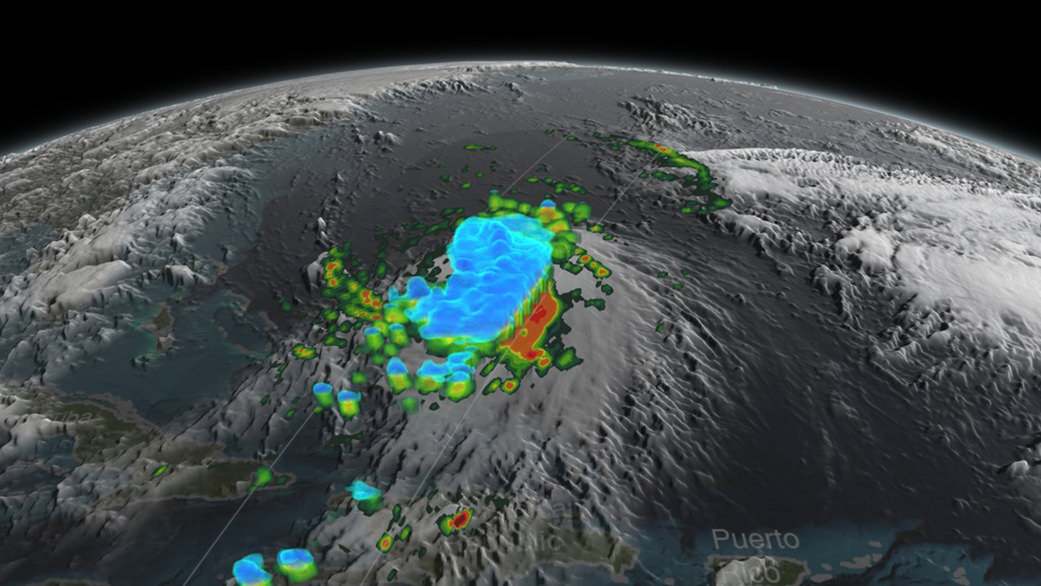
NASA/JAXA’s GPM satellite provided a 3-D side view of Tropical Storm Joaquin on Sept. 29 showing the internal precipitation structure. The areas in blue are frozen precipitation. Areas in green and red are liquid precipitation. Credits: Scientific Visualization Studio, NASA’s Goddard Space Flight Center
Coastal flood warnings and watches are already in effect in many areas along the eastern seaboard where local areas could be drenched by some 12 to 18 inches of additional rain which could fall even before the hurricane hits.
Significant beach erosion has already occurred in the Carolinas over the past few days and more is expected up and down the entire coast up to Maine.
And 10 foot high defense berms of sand are being constructed at this moment along miles and miles of the Jersey Shore – areas that suffered devastating damage from Superstorm Sandy.
There is a potential risk of deadly flooding, flash flooding and damage to houses, buildings, businesses, roadways and infrastructure.
“At 2 p.m. EDT (1800 UTC), the center of Hurricane Joaquin was located near latitude 23.0 North, longitude 74.2 West. Joaquin was moving generally southwestward at about 6 mph (9 kph), and the National Hurricane Center forecast a turn toward the northwest and north on Friday, Oct. 2. On the forecast track, the center of Joaquin will move near or over portions of the central Bahamas today and tonight and pass near or over portions of the northwestern Bahamas on Friday, Oct. 2,” according to NASAs Rob Gutro.
The weather forecast for Friday’s launch from Cape Canaveral , Florida is currently 70 percent GO for liftoff of the United Launch Alliance Atlas V rocket at 6:08 a.m. EDT. The Atlas V will launch with the Morelos-3 mission for Mexico’s Secretaria de Comunicaciones y Transportes (Ministry of Communications and Transportation).
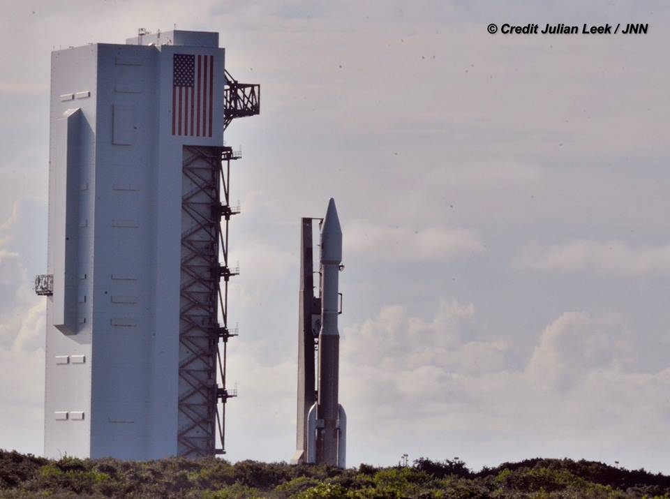
Morelos-3 will be part of the Mexsat constellation of satellites that delivers advanced telecommunications throughout Mexico. United Launch Alliance Atlas V rocket after rollout to Pad 41 at Cape Canaveral Air Force Station, Florida for planned Oct. 2 launch at 6:08 a.m. EDT with the Morelos-3 mission for Mexico’s Ministry of Communications and Transportation. In progress assembly of the commercial crew access tower is seen at right, now under construction for the Boeing Starliner space taxi for astronaut crews launching to the ISS. Credit: Julian Leek
Stay tuned here for Ken’s continuing Earth and planetary science and human spaceflight news.
United Launch Alliance Atlas V rocket during rollout to Space Launch Complex-41 at Cape Canaveral Air Force Station, Florida on Oct. 1 for planned Oct. 2 launch at 6:08 a.m. EDT with the Morelos-3 mission for Mexico’s Ministry of Communications and Transportation. Credit: Julian Leek
Weather looking a bit iffy tonight? Using the resources described below, you just might be able to escape the clouds. Credit: Bob King
We’ve arrived at eclipse day, so now the big question is, will it be clear? My favorite forecast for major astronomical events reads something like this: Fair skies tonight with light winds and lows in the middle 50s.While I hope that’s exactly what’s predicted for your town, in my corner of the world we’re expecting “increasing clouds with a chance for thunderstorms”.
That’s just not nice. Same by you? Here’s how to find that clear spot if you’re facing bad weather tonight.
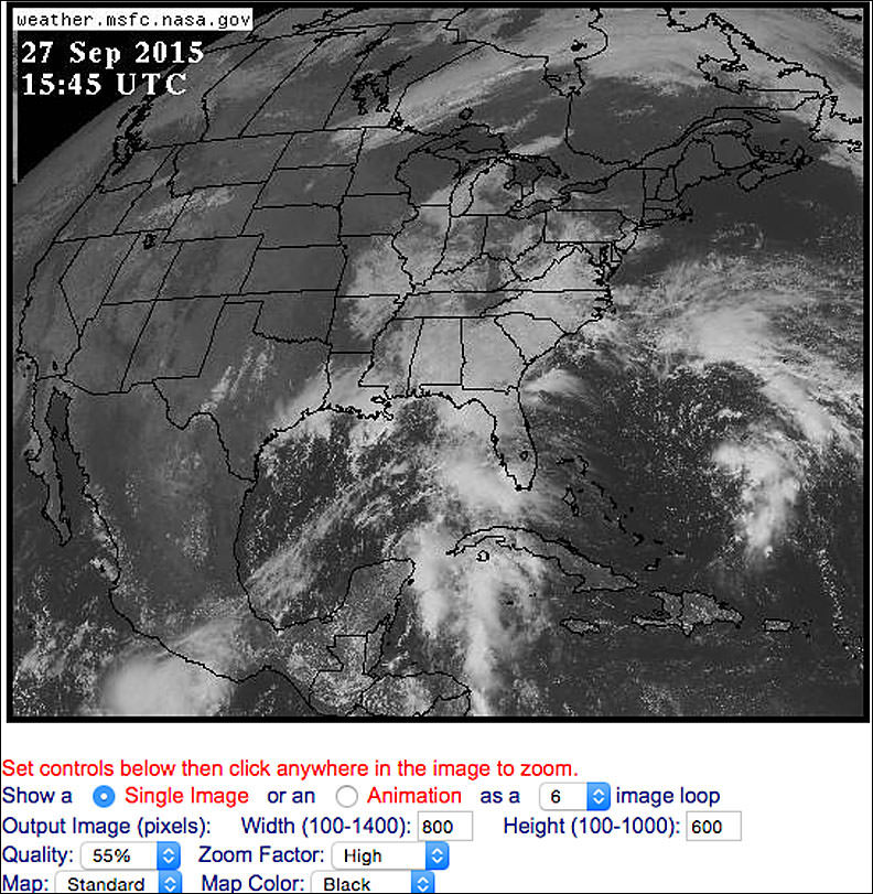
One of my favorite cloud-checking sites is the GOES East view of the U.S., Canada and Central America taken from geostationary orbit. This map shows the scene at 10:45 a.m. CDT this morning. Credit: NASA
I usually check the GOES (Geostationary Operational Environmental Satellite) images that weather forecasters use to display and animate the movement of clouds and weather fronts during the nightly newscasts. Once I know the location and general drift of the clouds, I get in a car and drive to where it’s likely to either remain or become clear. Depending on the “magnitude” of the event I might drive 50 to 150 miles. If nothing else, doing astronomy guarantees many adventures.
GOES West view of the western U.S., Canada and Hawaii taken at 11 a.m. CDT. Credit: NASA
You’ll find these most helpful images at either the GOES East site, which features a photo of the entire mainland U.S., Central America and much of Canada, updated every 15 minutes. Since the satellite taking the photos is centered over the 75° west parallel of longitude, its focus is primarily the eastern two-thirds of the U.S. and Canada. For the western U.S., western Canada and Hawaii, head over to the GOES West site.
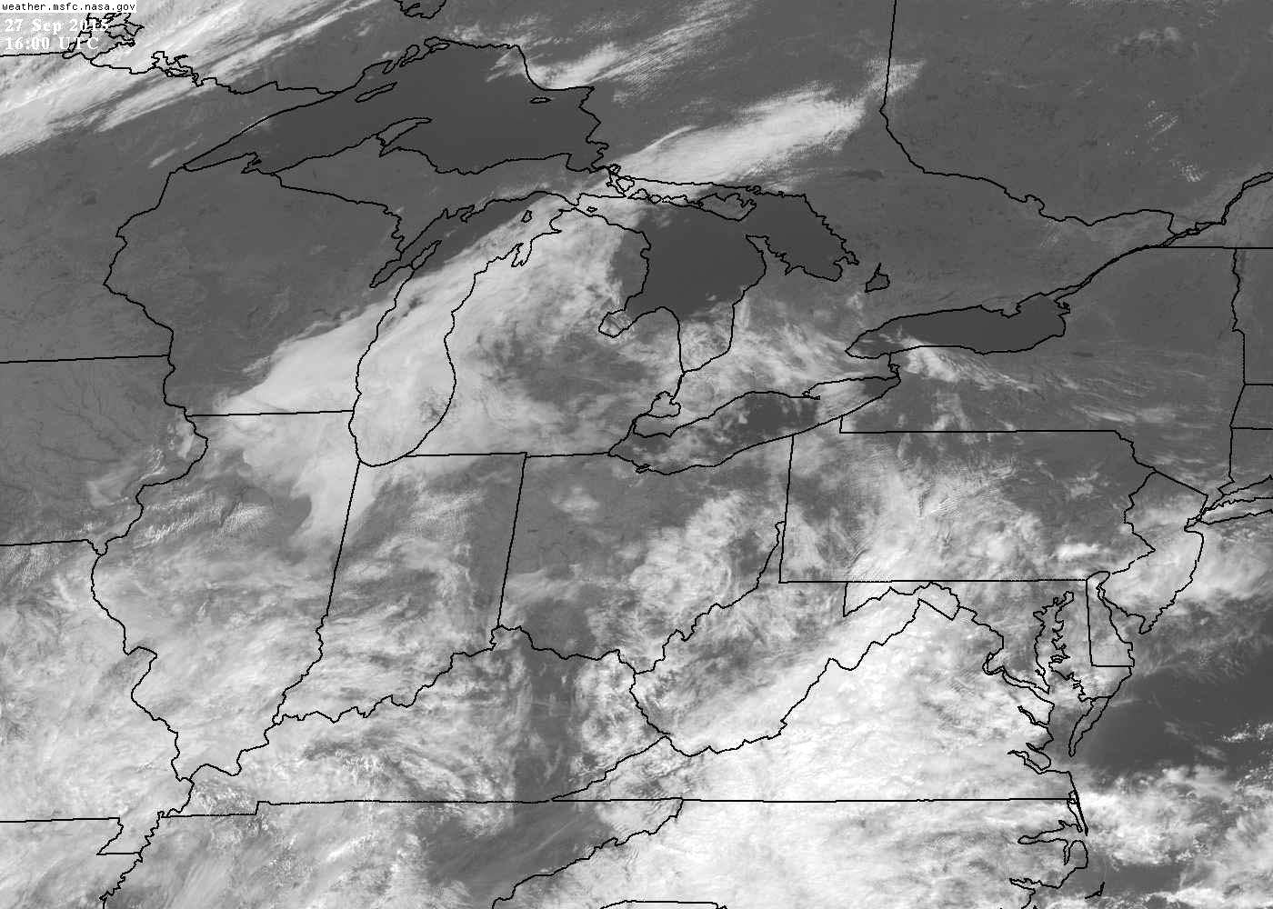
After you set the width and height to maximum values, you’ll get a picture like this, taken at 11 a.m. CDT. Credit: NASA
Once there, you’ll be presented with a big picture view of the U.S., etc., but you can click anywhere on the map for a zoomed-in look at a particular region. Before you do, set the “width” and “height” boxes to their maximum values of 1400 (width) and 1000 (height). That way you’ll get a full-screen, nifty, 1-kilometer image when you go in close. All images have a time stamp in the upper left corner given in Universal or Greenwich Mean Time (GMT). Subtract 4 hours to convert to Easter Daylight; 5 for CDT; 6 for MDT and 7 for PDT.
You can check back all day long for fresh photos and watch the march of the clouds over time. Or you can have the site assemble up to 30 of the most recent images into an animation loop and watch it as a movie. Combing current photos, the animation and your local forecast will inform your plans about whether to remain at home to watch the eclipse or get the heck out of town.
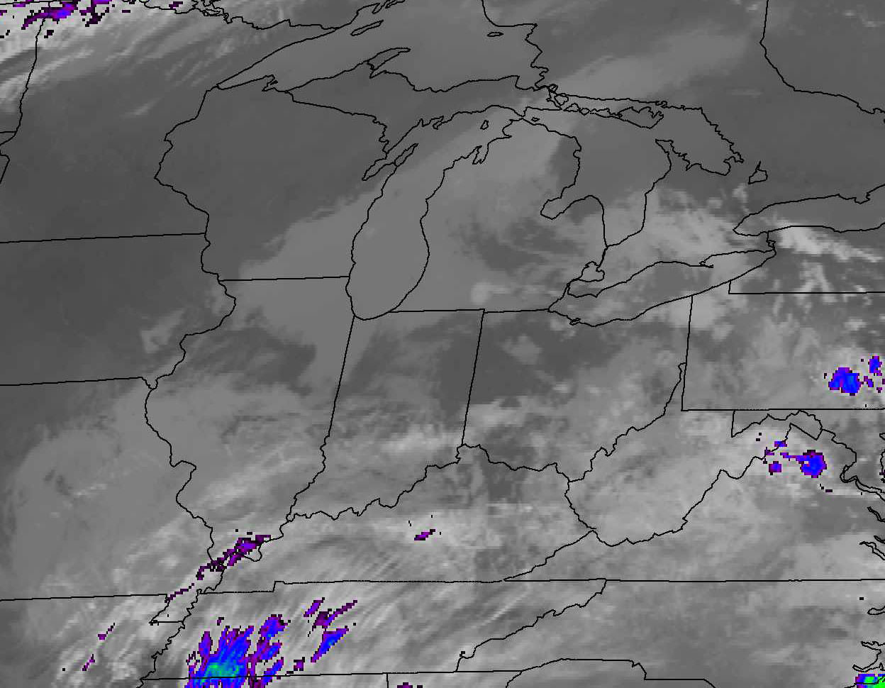
Infrared image of the east-central U.S. at 11 a.m. CDT today. Clouds can be seen and tracked at night using the infrared channel on the GOES East and West sites. Credit: NASA
When night arrives, you can still get a reasonably good idea of where the clouds are and aren’t by clicking on the infrared channel link at the top of the site. I also like to use the NCAR (National Center for Atmospheric Research Real-Time Weather Data) site. They offer a black and white infrared option that provides a clearer picture. At the site, select your “channel” then click on one of the regional acronyms on the interactive U.S. map.
So far, we’ve been talking about the weather in real time. When it comes to forecasts, one of the most useful tools of all and a true godsend to amateur astronomers is Attilla Danko’s ClearDarkSky site. Click on the Clear Sky Charts linkto access interactive charts for thousands of locations across the U.S., Canada and parts of Mexico. For example, if you click on Illinois, you’ll get a list of sky conditions for 105 locations throughout the state. The Chicagolink pops up six rows of data-packed squares with colors ranging from deep blue to white.
The cloud cover forecast for Chicago today Sept. 27 through early Tuesday Sept. 29 as depicted in Attilla Danko’s Clear Dark Sky site. The forecasts can be sponsored for a donation by various groups or individuals. This one is by the Chicago Astronomical Society. Copyright: Attilla Danko
The first row indicates cloud clover with varying shades of blue representing the percentage of clear sky. Medium blue means partly cloudy; white indicates 100% overcast. Additional data sets include sky transparency, seeing conditions, hours of darkness, wind, temperature and humidity. While no forecast is 100% accurate, the reliability of the models Danko uses makes Clear Sky Charts one of best tools available for skywatchers. Want a real treat? If you click on one of the squares in the Cloud Cover row, a large image showing cloud cover at the time will pop up. You’ll also find another, more general interactive cloud forecast graphic at WeatherForYou.com.
Thanks to a helpful reader suggestion, I recently learned of Clear Outside, a forecasting site similar to Clear Sky Charts but worldwide. Be sure to check it out. Satellite imagery like the U.S. GOES East and West is available for European and African observers at Sat24.
So what does the U.S. look like for weather tonight? Mostly clear skies are expected from New York State up through Maine, across the center of the country, the desert Southwest and the Northwest. Expect partly cloudy conditions (with some mostly cloudy spots) for the Upper and central Midwest, and mostly cloudy to overcast skies in the southern and southeastern seaboard states.
But who knows? By using these sites, you might just improve your chances of seeing what promises to be a spectacular lunar eclipse tonight. Some of you reading this undoubtedly have your own favorite weather hangouts. Please share them with us in the comments section. The more the merrier!
As always, if you’re completely shut out, here are a few sites where you can watch it live on the Web:
NASA Astronaut Scott Kelly took this picture of Hurricane Danny on August 20 at 6 a.m. EDT from aboard the International Space Station. Credits: NASA
Hurricane Danny, the first Atlantic Ocean hurricane of the 2015 season has been caught on camera by NASA astronautScott Kelly, in a beautiful image taken on Thursday, August 20 at 6 a.m. EDT from his glorious perch aboard the International Space Station (ISS).
Poking majestically down at the sprawling hurricane is the space stations Canadian-built robotic arm that will be used by Kelly in a few days to grapple Kounotori, the Japanese cargo ship launched earlier this week and berth it at a docking port.
Kelly is nearly five months into his year-long stay aboard the ISS and is a prolific photographer of the natural wonders of our home planet.
“Hurricane Danny. Keeping an eye on you from the International Space Station. Looks like you’re 1st in the Atlantic this year. Stay safe below! #YearInSpace,” wrote Kelly on his Facebook and twitter pages.
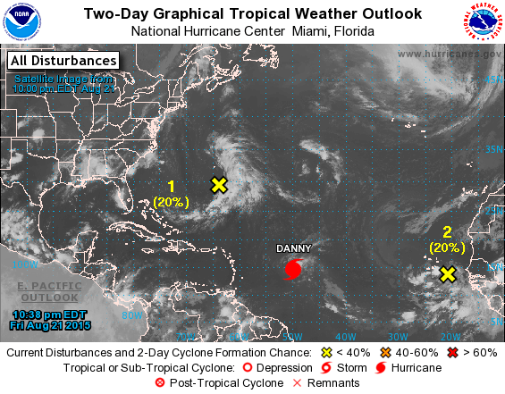
Danny had risen to a Category 3 hurricane by Friday afternoon, August 21, with winds over 115 mph and was moving westward in the Central Atlantic Ocean towards the Leeward Islands in the Caribbean.
By 11 a.m. EDT (1500 UTC) on Friday, August 21, the eye of Hurricane Danny was located near latitude 14.0 North, longitude 48.2 West, according to NASA. The center of Danny was about 930 miles (1,195 km) east of the Leeward Islands. With maximum sustained winds of near 105 mph (165 kph), Danny was a Category 2 hurricane on the Saffir-Simpson Hurricane Wind Scale.
By 8:00 p.m. Friday evening, Friday, the National Hurricane Center said Danny was located over the central tropical Atlantic Ocean about 800 miles east of the Leeward Islands.
Late this evening at 11 p.m., the National Hurricane Center said it had weakened slightly back to a Category 2 storm with maximum winds of 110 mph and was located at 14.8°N and 49.8°W while moving west northwest at 10 mph.
The NASA GOES-East animation below combines visible and infrared imagery showing Hurricane Danny’s movement in the eastern and central Atlantic Ocean from Aug. 18 to 21, 2015.
Video caption: Hurricane Danny Seen By GOES-East. This animation of visible and infrared imagery of Hurricane Danny in the Central Atlantic Ocean was taken from NOAA’s GOES-East satellite from Aug. 18 to 21. Credits: NASA/NOAA GOES Project
Forecasters with the National Hurricane Center think it may weaken over the next few days as it heads towards the Caribbean islands.
“Vertical shear is expected to increase further during the next couple of days, which should allow drier air in the surrounding environment to penetrate into Danny’s circulation. Therefore,there is no change in the thinking that Danny should weaken as it approaches and moves across the Leeward Islands and the Greater Antilles during the forecast period.”
Danny could reach Puerto Rico by Monday in a weakened state.
Although it’s still far away from the US, it’s not expected to impact the East Coast but that could change.
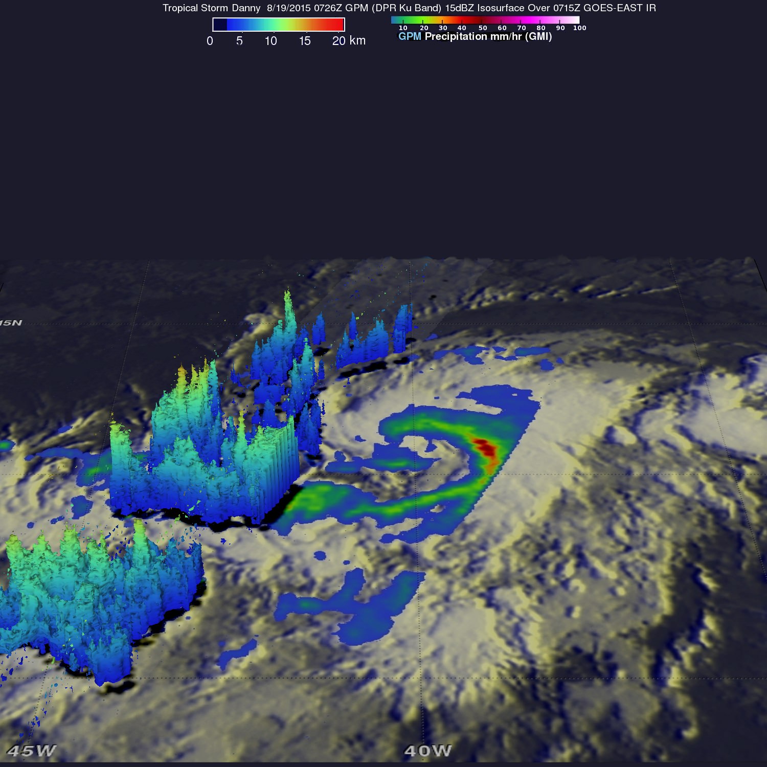
On Aug. 19, 2015 GPM saw Danny’s rain structure was still asymmetric as noted by the large rain band (identified by the green arc indicating moderate rain) being located mainly on the eastern side of the storm. Within this rain band, GPM detected rain rates of up to 73.9 mm/hour (shown in darker red).Credits: SSAI/NASA, Hal Pierce
“GPM showed that Danny was still in the process of becoming organized. The rain structure was still very asymmetric as noted by a large rain band being located mainly on the eastern side of the storm. Within this rain band, GPM detected rain rates of up to 73.9 mm/hour. At the time of this image, Danny was still a minimal tropical storm with sustained winds estimated at 50 mph by the National Hurricane Center (NHC),” said officials.
And dont forget that you can watch Commander Scott Kelly and his five international crew mates on a regular basis as they soar overhead. Just click on NASA’s Spot the Station link and plug in your location.
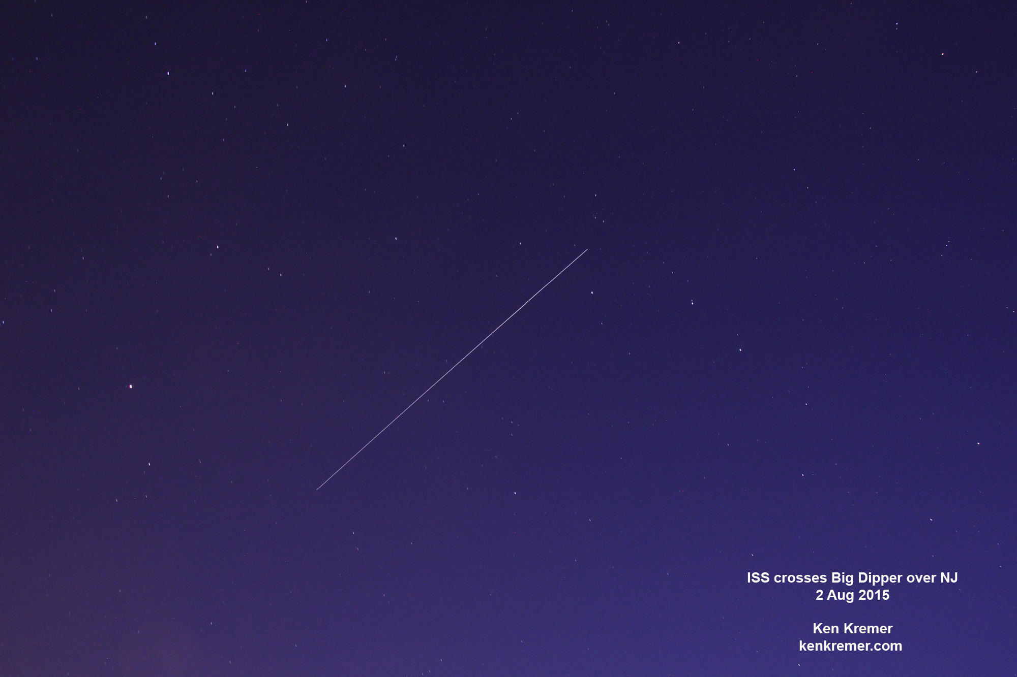
ISS crosses the Big Dipper over NJ. Credit: Ken Kremer/kenkremer.com
Stay tuned here for Ken’s continuing Earth and planetary science and human spaceflight news.
NASA-NOAA Suomi NPP satellite captures blizzard near peak intensity as it moves over New York and Boston regions at 1:45 am EST, Jan. 27, 2015. This view is a combination of the day-night band and high resolution infrared imagery from Suomi NPP showing the historic blizzard near peak intensity as it moves over the New York through Boston Metropolitan areas at 06:45Z (1:45 a.m. EST) on January 27, 2015. Credit: NOAA/NASA
NEW JERSEY – Record breaking snow from the ‘Blizzard of 2015’ hit vast regions of the US Northeast today, Jan. 27, 2015, stretching from Long Island to New England.
NASA and NOAA Earth orbiting satellites are keeping track of the storm affecting millions of residents.
This afternoon the agencies provided a new set of night-time and daytime views of the Blizzard of 2015 taken by the Suomi NPP and the GOES-East satellites.
The crippling blizzard is causing misery, extensive destruction to homes and businesses in localized areas, power outages, traffic accidents, breaks in some sea walls and deaths.
The satellite image above shows a combination of the day-night band and high resolution infrared imagery from the NASA-NOAA’s Suomi NPP satellite.
It was taken as the historic blizzard neared peak intensity as it moved over the New York area and through the Boston Metropolitan areas at 06:45Z (1:45 a.m. EST) on January 27, 2015.
The high cloud tops from the most intense parts of the storm blurred the regions normally bright nighttime lights in the satellite image.
Although the snow totals were about half the over two feet forecast for the New York Metropolitan region, many areas to the north and east were inundated with very heavy to historic snow fall totals, as bad or worse than the forecasters predicted.
Over two feet of snow fell on areas of New York’s Long Island and stretching north to vast regions of Connecticut, Massachusetts, New Hampshire and into Maine.
Near hurricane force waves are crashing into some coastal towns along the Massachusetts shoreline. Wind gusts as high as 78 mph have been recorded.
“Highest snowfall report has been Auburn, MA with 32.5 inches! Wind gust reports as high as 78 mph in Nantucket, MA,” according to a tweet this evening from the National Weather Service (NWS).
Worchester, Mass had a record breaking 31 inches of snow. And it’s still falling this evening in the 2nd largest city in New England.
A flood emergency is in effect in Marshfield, Mass., where an 80 foot section of the seawall was smashed by crashing waves and is destroying homes as shown on NBC Nightly News.
Blinding snow is raging in Portland, Maine this evening according on a live NBC News report.
On January 27, 2015 at 17:35 UTC (12:35 p.m. EST) NOAA’s Geostationary Operational Environmental or GOES- East satellite captured an image of the nor’easter over New England. Credit: NASA/NOAA GOES Project
“At 10 a.m. EST, the National Weather Service noted “the powerful nor’easter that brought moderate to heavy snowfall and blizzard conditions to the Northeast on Monday will continue to affect the region on Tuesday, with heavy snow and blizzard conditions expected from eastern Long Island to Maine as the system slowly moves to the northeast. Snow and strong winds will being tapering off from south to north Tuesday night into Wednesday morning,” wrote NASA’s Rob Gutro of NASA’s Goddard Space Flight Center in an update.
“Later on January 27, 2015 at 17:35 UTC (12:35 p.m. EST) NOAA’s Geostationary Operational Environmental or GOES-East satellite captured an image of the nor’easter over New England. The image was created by the NASA/NOAA GOES Project and showed the clouds associated with the nor’easter blanketing New England. An occluded front extended north and eastward out of the low pressure area’s center out into the Atlantic Ocean.”
The latest NOAA forecast as of 4 PM, Jan. 27 states:
HIGH WINDS AND HEAVY SNOW WILL BEGIN TO GRADUALLY TAPER OFF FROM SOUTH TO NORTH TONIGHT…BUT WILL LAST INTO EARLY WEDNESDAY MORNING ACROSS PORTIONS OF MAINE. HEAVY SNOWFALL WILL COMBINE WITH SUSTAINED WINDS OF 30 TO 40 MPH…AND GUSTS IN EXCESS OF 50 MPH…TO CREATE LIFE-THREATENING WHITEOUT OR BLIZZARD CONDITIONS. THESE WINDS MAY LEAD TO DOWNED TREES AND POWER LINES RESULTING IN POWER OUTAGES. TRAVEL WILL BE IMPOSSIBLE AND LIFE-THREATENING IN MANY AREAS. ALONG THE IMMEDIATE COASTLINE…WIND GUSTS TO NEAR 65 MPH WILL BE POSSIBLE. COASTAL FLOODING AND SEVERE BEACH EROSION WILL ALSO BE A POSSIBILITY…AND VULNERABLE ROADS AND STRUCTURES MAY BE FLOODED OR DAMAGED.
Stay tuned here for Ken’s continuing Earth and planetary science and human spaceflight news.