This is Our Planet From a Million Miles Away

Earth imaged on July 6, 2015 by NOAA's DSCOVR satellite from L1. Credit: NOAA/NASA/GSFC

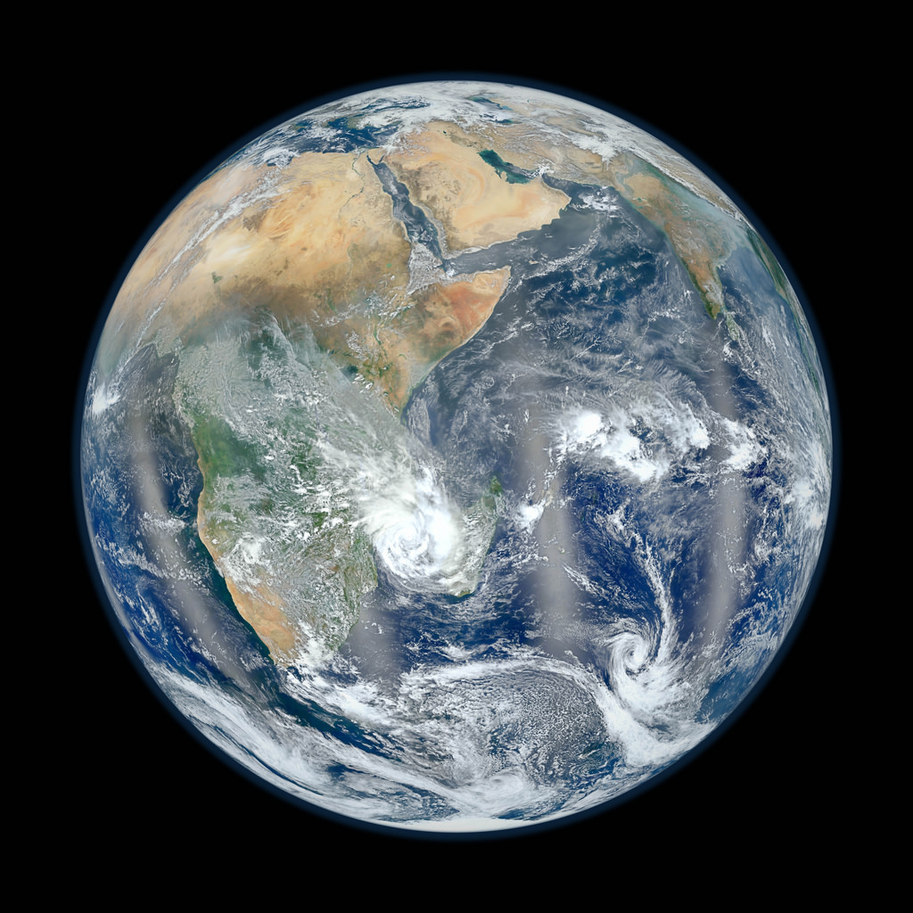
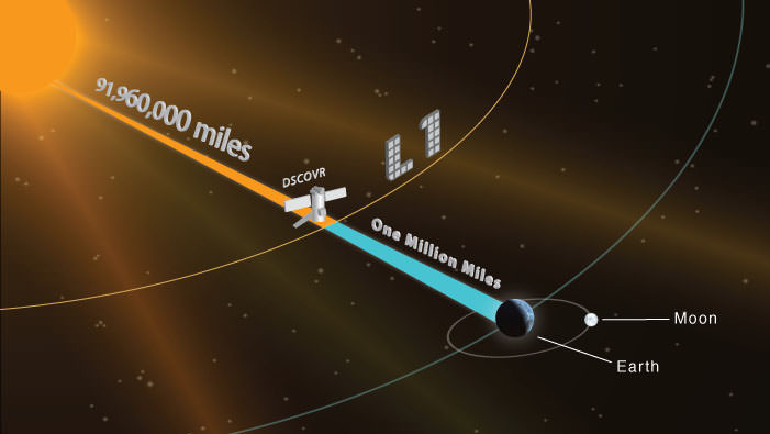
This picture of our home planet truly is EPIC – literally! The full-globe image was acquired with NASA’s Earth Polychromatic Imaging Camera (aka EPIC; see what they did there) on board NOAA’s DSCOVR spacecraft, positioned nearly a million miles (1.5 million km) away at L1.

L1 is one of five Lagrange points that exist in space where the gravitational pull between Earth and the Sun are sort of canceled out, allowing spacecraft to be “parked” there. (Learn more about Lagrange points here.) Launched aboard a SpaceX Falcon 9 on Feb. 11, 2015, the Deep Space Climate Observatory (DSCOVR) arrived at L1 on June 8 and, after a series of instrument checks, captured the image of Earth’s western hemisphere above on July 6.

The EPIC instrument has the capability to capture images in ten narrowband channels from infrared to ultraviolet; the true-color picture above was made from images acquired in red, green, and blue visible-light wavelengths.

More than just a pretty picture of our blue marble, this image will be used by the EPIC team to help calibrate the instrument to remove some of the blue atmospheric haze from subsequent images. Once the camera is fully set to begin operations daily images of our planet will be made available on a dedicated web site starting in September.

DSCOVR's location at L1 (NOAA/NASA)
DSCOVR’s location at L1 (NOAA/NASA)

Designed to provide early warnings of potentially-disruptive geomagnetic storms resulting from solar outbursts, DSCOVR also carries Earth-observing instruments that will monitor ozone and aerosols in the atmosphere and measure the amount of energy received, reflected, and emitted by Earth – the planet’s “energy budget.

But also, from its permanent location a million miles away, DSCOVR will be able to get some truly beautiful – er, EPIC – images of our world.

DSCOVR is a joint mission between NOAA, NASA, and the U.S. Air Force. Learn more about DSCOVR here.

Source: NASA

UPDATE: President Obama liked this image so much, he decided to Tweet about it with a message of planetary conservation!

The POTUS' Tweet about the DSCOVR image on July 20, 2015.
The POTUS’ Tweet about the DSCOVR image on July 20, 2015.

UPDATE 7/29/15: Here’s another view from DSCOVR on July 6, showing Europe, Africa, and the Middle East:

DSCOVR image of Earth from July 6, 2015. (NASA/NOAA)

From Russia With Love: A Singularly Stunning Image of Earth

Full-disk image of Earth from Russia's Elektro-L satellite. (NTs OMZ)

[/caption]

Unlike most satellite images of Earth, this one was not assembled from multiple swath scans or digitally projected onto a globe model — it’s the full disk of our planet in captured as a single, enormous 121 megapixel image, acquired by Russia’s Elektro-L weather-forecasting satellite.

Like NASA’s GOES satellites, Elektro-L is parked in a geostationary orbit approximately 36,000 km (22,300 miles) above our planet. Unlike NASA’s satellites, however, Elektro-L captures images in near-infrared as well as visible wavelengths, providing detail about not only cloud movement but also vegetation variations. Its wide-angle Multichannel Scanning Unit (MSU) takes images every 15-30 minutes, showing the same viewpoint of Earth across progressive times of the day.

At a resolution of 0.62 miles per pixel, full-size Elektro-L images are some of the most detailed images of Earth acquired by a weather satellite.

Download the full-size image here (100+ megabytes).

Elektro-L diagram. © 2009 Anatoly Zak

Launched aboard a Zenit rocket on January 20, 2011, Elektro-L was the first major spacecraft to be developed in post-Soviet Russia. Parked over Earth at 76 degrees east longitude, Elektro-L provides local and global weather forecasting and analysis of ocean conditions, as well as “space weather” monitoring — measurements of solar radiation and how it interacts with Earth’s magnetic field. Its initial lifespan is projected to be ten years.

A second Elektro-L satellite is anticipated to launch in 2013.

Image credit: Russian Federal Space Agency / Research Center for Earth Operative Monitoring (NTS OMZ). See more images and video from Elektro-L on James Drake’s Planet Earth here. (Tip of the geostationary hat to Jesus Diaz at Gizmodo.)

Earth Has Less Water Than You Think

All the water on Earth would fit into a sphere 860 miles (1,385 km) wide. (Jack Cook/WHOI/USGS)

[/caption]

If you were to take all of the water on Earth — all of the fresh water, sea water, ground water, water vapor and water inside our bodies — take all of it and somehow collect it into a single, giant sphere of liquid, how big do you think it would be?

According to the U. S. Geological Survey, it would make a ball 860 miles (1,385 km) in diameter, about as wide edge-to-edge as the distance between Salt Lake City to Topeka, Kansas. That’s it. Take all the water on Earth and you’d have a blue sphere less than a third the size of the Moon.

Feeling a little thirsty?

And this takes into consideration all the Earth’s water… even the stuff humans can’t drink or directly access, like salt water, water vapor in the atmosphere and the water locked up in the ice caps. In fact, if you were to take into consideration only the fresh water on Earth (which is 2.5% of the total) you’d get a much smaller sphere… less than 100 miles (160 km) across.

Even though we think of reservoirs, lakes and rivers when we picture Earth’s fresh water supply, in reality most of it is beneath the surface — up to 2 million cubic miles (8.4 million cubic km) of Earth’s available fresh water is underground. But the vast majority of it — over 7 million cubic miles (29.2 cubic km) is in the ice sheets that cover Antarctica and Greenland.

Of course, the illustration above (made by Jack Cook at the Woods Hole Oceanographic Institution) belies the real size and mass of such a sphere of pure liquid water. The total amount of water contained within would still be quite impressive — over 332.5 million cubic miles (1,386 cubic km)! (A single cubic mile of water equals 1.1 trillion gallons.) Still, people tend to be surprised at the size of such a hypothetical sphere compared with our planet as a whole, especially when they’ve become used to the description of Earth as a “watery world”.

Makes one a little less apt to take it for granted.

Read more on the USGS site here, and check out some facts on reducing your water usage here.

Water, water, every where,
And all the boards did shrink;
Water, water, every where,
Nor any drop to drink.
– from The Rime of the Ancient Mariner, Samuel Taylor Coleridge

Earthrise, Revisited

The first color photo of Earth taken from orbit around the Moon. (NASA)


On December 24, 1968, Apollo 8 astronauts Frank Borman, William Anders and Jim Lovell were the first humans to witness an Earthrise as our home planet came up over the lunar horizon. The photos they captured were the first of their kind, instantly inspiring the imaginations of millions and highlighting the beauty and fragility of our world.

Now, NASA has used modern satellite data to recreate the scenes that the Apollo 8 astronauts saw 44 years ago and combined them with their historic photographs to present a new “Earthrise”… version 2.0.

Created in recognition of Earth Day 2012, the Earthrise animation was made from data acquired by NASA’s Lunar Reconnaissance Orbiter’s laser altimeter, as well as the Moderate Resolution Imaging Spectroradiometer (MODIS) on the Terra Earth-observing satellite.

“This visualization recreates for everyone the wondrous experience of seeing Earth from that privileged viewpoint,” says LRO Project Scientist Rich Vondrak of NASA’s Goddard Space Flight Center.

Animator Ernie Wright recreated the scene using Apollo mission reports and photos taken by the crew. The audio is a recording of original communication from the astronauts.

[/caption]

“I think the one overwhelming emotion that we had was when we saw the earth rising in the distance over the lunar landscape… it makes us realize that we all do exist on one small globe. For from 230,000 miles away it really is a small planet.”

— Frank Borman, Apollo 8 Commander

Read the release on the NASA LRO site here.

Video: NASA/GSFC

NASA’s Blue Marble…Side B.

Earth's eastern hemisphere made from Suomi NPP satellite images. (NASA/NOAA)

[/caption]

In response to last week’s incredibly popular “Blue Marble” image, NASA and NOAA have released a companion version, this one showing part of our planet’s eastern hemisphere.

The image is a composite, made from six separate high-resolution scans taken on January 23 by NASA’s recently-renamed Suomi NPP satellite.

From the description on NASA Goddard Space Flight Center’s Flickr page:

Compiled by NASA Goddard scientist Norman Kuring, this image has the perspective of a viewer looking down from 7,918 miles (about 12,742 kilometers) above the Earth’s surface from a viewpoint of 10 degrees South by 45 degrees East. The four vertical lines of ‘haze’ visible in this image shows the reflection of sunlight off the ocean, or ‘glint,’ that VIIRS captured as it orbited the globe. Suomi NPP is the result of a partnership between NASA, NOAA and the Department of Defense.

Last week’s “Blue Marble” image is now one of the most-viewed images of all time on Flickr, receiving nearly 3.2 million views!

See the previously released image here.

NASA launched the National Polar-orbiting Operational Environmental Satellite System Preparatory Project (or NPP) on October 28, 2011 from Vandenberg Air Force Base. On Jan. 24, NPP was renamed Suomi National Polar-orbiting Partnership, or Suomi NPP, in honor of the late Verner E. Suomi. It’s the first satellite designed to collect data to improve short-term weather forecasts and increase understanding of long-term climate change.

Image credit: NASA/NOAA

Added: check out a “zoomified” version of this image on John Williams’ StarryCritters site.