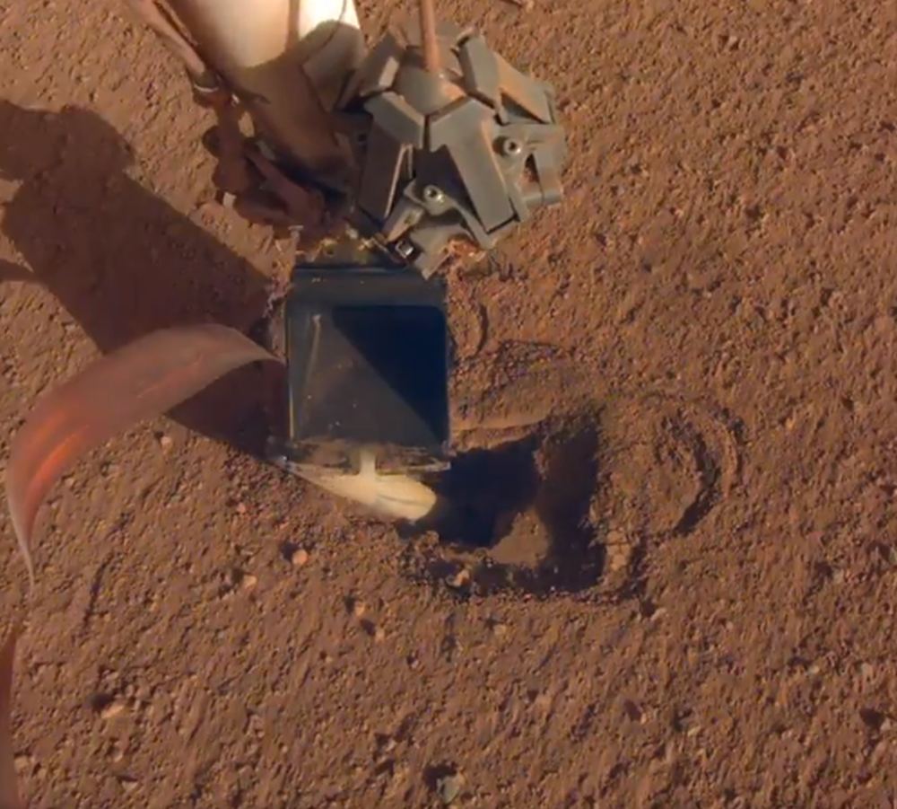
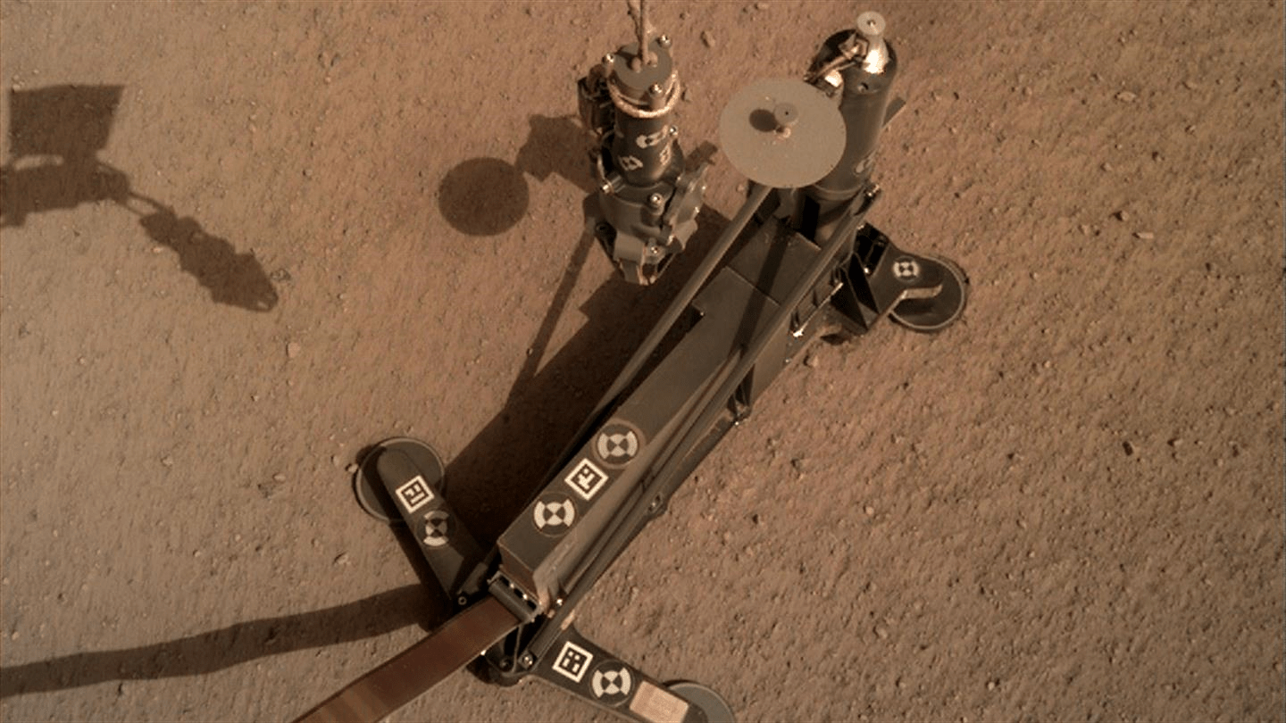
On June 4th NASA reported that the Mole is finally making some headway. But the instrument is not producing any science yet. Image Credit: NASA/DLR/JPL
It looks like the InSight Lander’s Mole instrument is making some progress. After months of perseverance, the team operating the instrument has succeeded in getting the Mole at least some distance into the ground.
That’s a victory in itself, considering all the setbacks there’ve been. But it’s too soon to celebrate: there’s quite a ways to go before the Mole can deliver any science.
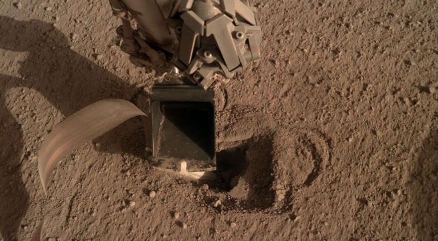
Engineers are using the scoop at the end of InSight's robotic arm to gently push on the Mole as it works its way into the ground. Image Credit: NASA/JPL/DLR
Personnel at NASA and the DLR have been working for months to get InSight’s Mole working. They’re at a disadvantage, since the average distance between Earth and Mars is about 225 million km (140 million miles.) They’ve tried a number of things to get the Mole into the ground, and they may finally be making some progress.
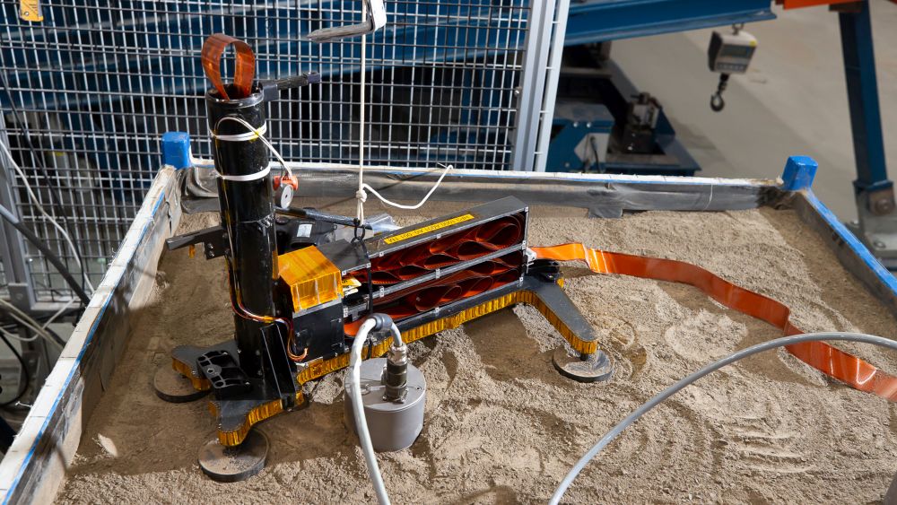
The HP3 model in its test bed in Bremen. Image Credit: DLR.
Engineers at the German Aerospace Center (Deutsches Zentrum für Luft- und Raumfahrt; DLR) are busy working with a replica InSight Lander to see if they can understand what’s blocking the lander’s mole.
The mole is the short name for the lander’s Heat Probe, which is hammering its way into the Martian surface. The Heat Probe is actually called the HP3, or Heat and Physical Properties Package. It’s designed to work it’s way as far as 5 meters (16.4 ft.) into the soil, where it will measure the heat flowing from the interior of the planet. Those measurements will tell scientists a lot about the structure of Mars, and how rocky planets formed.
But as reported last month, the probe is being blocked at about 30 cm (1 ft.)
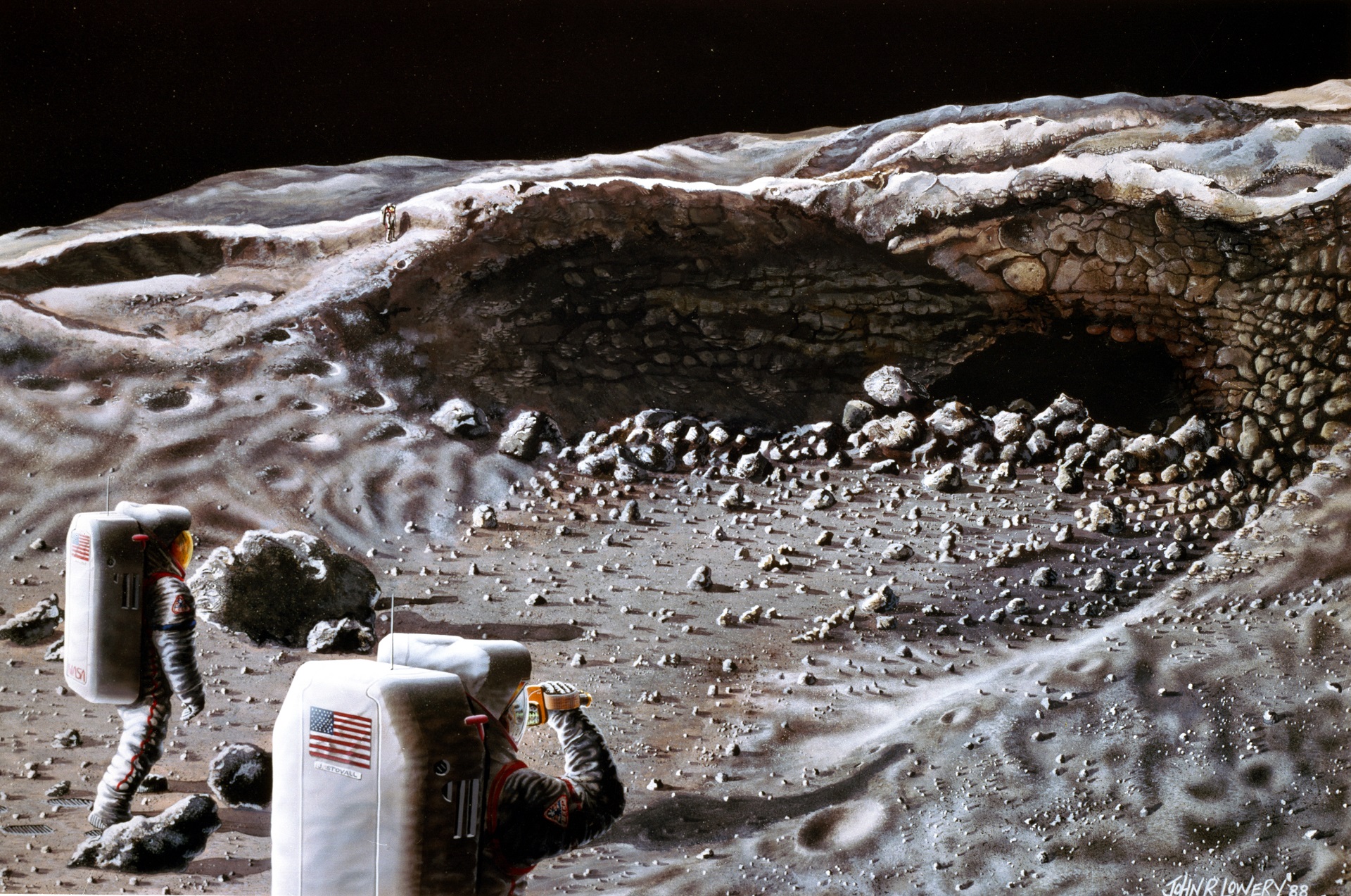
Here, a surface exploration crew begins its investigation of a typical, small lava tunnel, to determine if it could serve as a natural shelter for the habitation modules of a Lunar Base. Credit: NASA's Johnson Space Center
July 20st, 2019, will mark the 50th anniversary of the historic Moon Landing, where astronauts Neil Armstrong and Buzz Aldrin set foot on the lunar surface for the first time. This accomplishment was the high point of the “Space Race” and has remained NASA’s crowning achievement in space. In the coming years, NASA will attempt to return to the Moon, where they will be joined by several other space agencies.
To prepare for these eventual missions, a group of cosmonauts recently commenced an isolation experiment that will simulate a long-term mission to the Moon. It’s called the SIRIUS-19 experiment, which began earlier today at 02:00 p.m. local time (04:00 a.m. PDT; 07:00 a.m. EDT) at the Russian Academy of Sciences’ Institute of Biomedical Problems (IBMP) in Moscow.
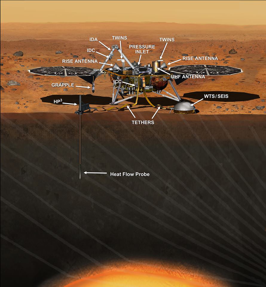
The Heat Flow and Physical Properties Package deployed on the Martian surface. Image Credit: NASA/DLR
NASA’s InSight lander is busy deploying its Heat Flow and Physical Properties Package (HP3) into the Martian soil and has encountered some resistance. The German Aerospace Center (DLR), who designed and built the HP3 as part of the InSight mission, has announced that the instrument has hit not one, but two rocks in the sub-surface. For now the HP3 is in a resting phase, and it’s not clear what will happen next.
This artist's concept depicts the InSight lander on Mars after the lander's robotic arm has deployed a seismometer and a heat probe directly onto the ground. InSight is the first mission dedicated to investigating the deep interior of Mars. The findings will advance understanding of how all rocky planets, including Earth, formed and evolved. NASA approved a new launch date in May 2018. Credits: NASA/JPL-Caltech
NASA managers have just made the difficult but unavoidable decision to scrub the planned March 2016 launch of the InSight lander, the agency’s next mission to Mars, by at least two years because of a vacuum leak that was just detected in the probes flawed seismometer instrument which cannot be fixed in time.
Scene from ‘The Martian’ starring Matt Damon as NASA astronaut Mark Watney contemplating magnificent panoramic vista while stranded alone on Mars. Credits: 20th Century Fox
Scene from ‘The Martian’ starring Matt Damon as NASA astronaut Mark Watney contemplating magnificent panoramic vista while stranded alone on Mars.
Credits: 20th Century Fox
See real Martian maps and flyover video from DLR and NSA below
Story/imagery updated[/caption]
Go now and experience Hollywood’s blockbuster new space epic ‘The Martian’ helmed by world renowned director Ridley Scott and starring Matt Damon as the protagonist, NASA astronaut Mark Watney. And you can follow Watney’s dramatic fictional path across the Red Planet in newly released real photos and a flyover video of the region, from DLR and NASA, as it looks today.
‘The Martian’ is a mesmerizingly enjoyable cinematic triumph for everyone that’s all about science, space exploration and one man’s struggle to survive while left totally isolated on the Red Planet in the face of seemingly insurmountable odds – relying on his wits alone to endure “on a planet where nothing grows” while hoping somehow for a rescue by NASA four years in the future.
The movie combines compelling and plausible storytelling with outstanding special effects that’s clearly delighting huge audiences worldwide with a positive and uplifting view of what could be achieved in the future – if only we really put our minds to it!
Based on the bestselling book by Andy Weir, ‘The Martian’ movie from 20th Century Fox tells the spellbinding story of how NASA astronaut Mark Watney is accidentally stranded on the surface of Mars during the future Ares 3 manned expedition in 2035, after a sudden and unexpectedly fierce dust storm forces the rest of the six person crew – commanded by Jessica Chastain as Commander Lewis – to quickly evacuate after they believe he is dead.
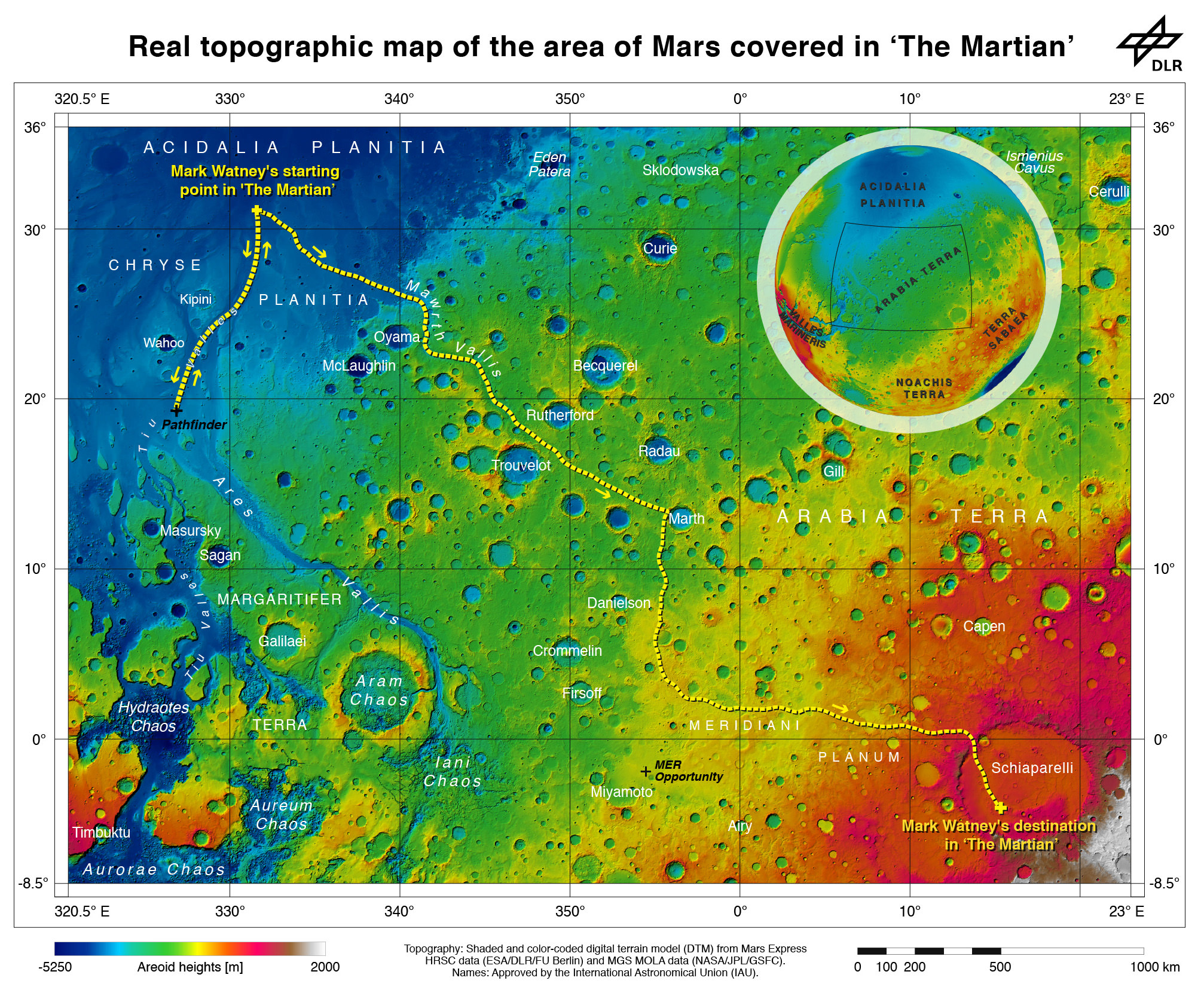
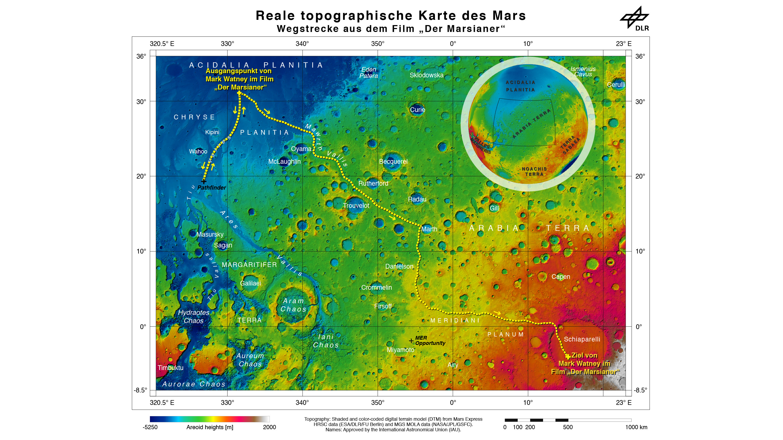
Real topographic map of the area of Mars covered in ‘The Martian.’ Follow the path of Mark Watney’s fictional endeavors from the Ares 3 landing site at Acidalia Planitia to NASA’s real Mars Pathfinder lander at the mouths of Ares Vallis and Tiu Valles and back, and finally to the Ares 4 landing site at Schiaparelli Crater. Credit: DLR/ESA/NASA
Now you can follow the fictional exploits of Mark Watney’s stunningly beautiful trail across the real Mars through a set of newly released maps, imagery and a 3D video created by the DLR, the German Aerospace Agency, and NASA – and based on photos taken by the European Space Agency’s Mars Express orbiter and NASA’s Mars Reconnaissance Orbiter (MRO).
DLR’s stunning 3D overflight video sequence was created from a dataset of 7300 stereo images covering roughly two-and-a-half million square kilometres of precisely mapped Martian landscape captured over the past 12 years by Mars Express High Resolution Stereo Camera (HRSC). The electric score is by Stephan Elgner.
Video Caption: Following the path of The Martian – video generated using images acquired by the Mars Express orbiter. Scientists from German Aerospace Center, DLR– who specialise in producing highly accurate topographical maps of Mars – reconstructed Watney’s route using stereo image data acquired by the High Resolution Stereo Camera on board European Space Agency’s #MarsExpress spacecraft. They then compiled this data into a video that shows the spectacular landscape that the protagonist would see ‘in the future’ on his trek from Ares 3 at Acidalia Planitia/Chryse Planitia to Ares 4 at Schiaparelli Crater. Credit: DLR/ESA
Ridley Scotts ‘The Martian’ takes place mostly on the surface of the Red Planet and is chock full of breathtakingly beautiful panoramic vistas. In the book you can only imagine Mars. In the movie Scott’s talents shine as he immerses you in all the action on the alien world of Mars from the opening scene.
Starting with the landing site for Watney’s Ares 3 mission crew at Acidalia Planitia, the book and movie follows his triumphs and tribulations, failures and successes as he logically solves one challenging problem after another – only to face increasingly daunting and unexpected hurdles as time goes by and supplies run low.
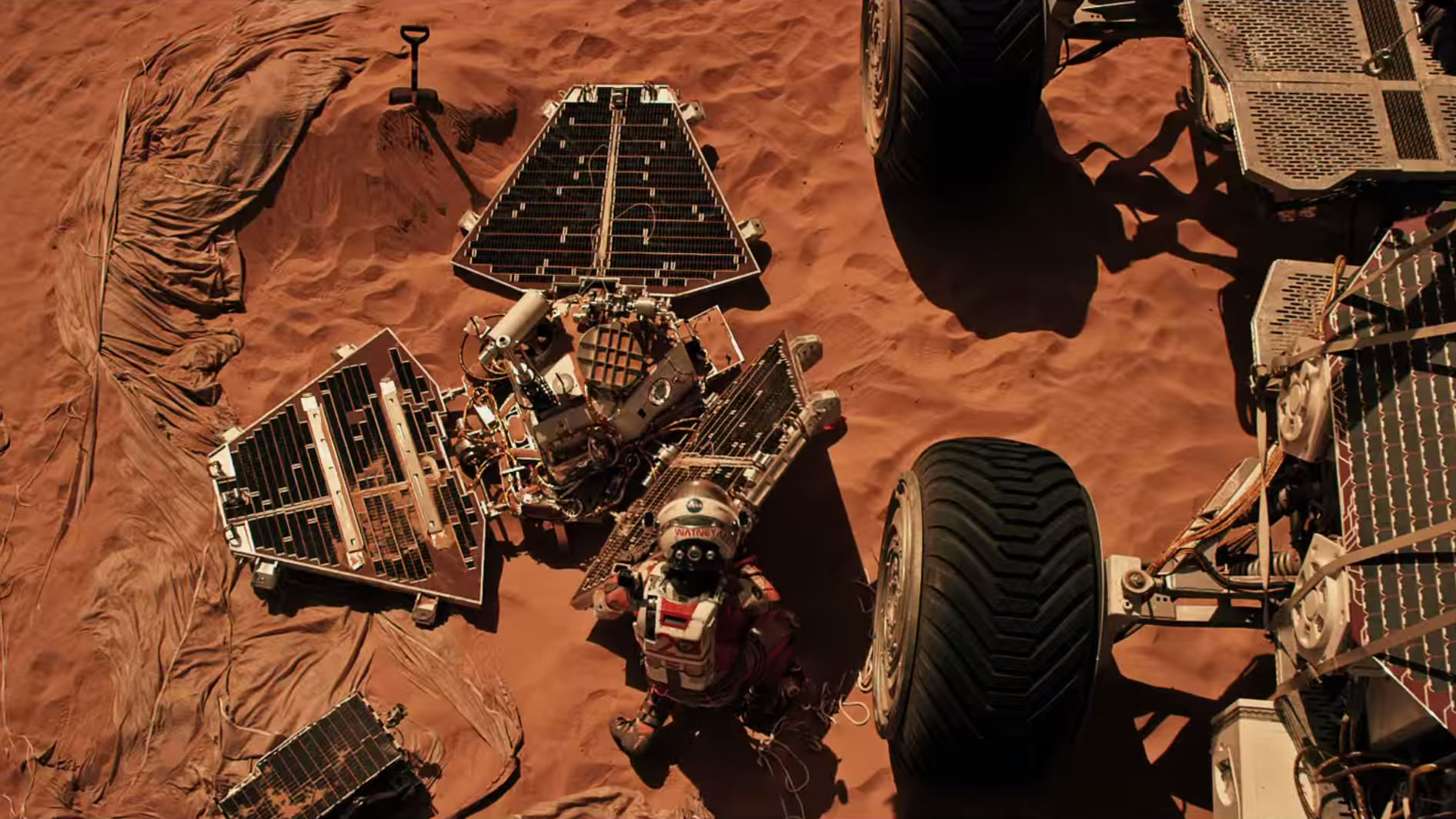
The DLR route map shows a real topographic view of Watney’s initial journey back and forth from the fictional Ares 3 landing site to the actual landing site of NASA’s 1997 Mars Pathfinder lander and Sojourner rover mission at the mouth of Ares Vallis.
Mark Watney arrives at the NASA’s 1997 Pathfinder lander to gather communications gear in a scene from “The Martian.” People and technology from NASA’s Jet Propulsion Laboratory aid fictional astronaut Mark Watney during his epic survival story in “The Martian.” Credits: 20th Century Fox
The map continues with Watney’s months-long epic trek to the fictional landing site of Ares 4 Mars Ascent Vehicle (MAV) spacecraft at Schiaparelli Crater, by way of Marth Valles and other Martian landmarks, craters and valleys.
At the request of Andy Weir, the HiRISE camera on NASA’s MRO orbiter took photos of the Martian plain at the Ares 3 landing site in Acidalia Planitia, which is within driving distance from the Pathfinder lander and Sojourner rover in the book and movie.
This May 2015 image from the HiRISE camera on NASA’s Mars Reconnaissance Orbiter shows a location on Mars associated with the best-selling novel and Hollywood movie, “The Martian.” It is in a region called Acidalia Planitia, at the landing site for the science-fiction tale’s Ares 3 mission. For the story’s central character, Acidalia Planitia is within driving distance from where NASA’s Mars Pathfinder, with its Sojourner rover, landed in 1997. Credits: NASA/JPL-Caltech/Univ. of Arizona
The Martian is all about how Watney uses his botany, chemistry and engineering skills to “Science the sh** out of it” to grow food and survive until the hoped for NASA rescue.
Learning how to live off the land will be a key hurdle towards enabling NASA’s real strategy for long term space voyages on a ‘Journey to Mars’ and back.
‘The Martian’ is a must see movie that broadly appeals to space enthusiasts and general audiences alike who can easily identify with Watney’s ingenuity and will to live.
Since its worldwide premiere on Oct. 2, ‘The Martian’ has skyrocketed to the top of the US box office for the second weekend in a row, hauling in some $37.3 million. The total domestic box office receipts now top $108 million and rockets to over $228 million worldwide in the first 10 days alone.
I absolutely loved ‘The Martian’ when I first saw the movie on opening weekend. And enjoyed it even more the second time, when I could pick up a few details I missed the first time around.
Matt Damon stars as NASA astronaut Mark Watney in ‘The Martian.’ Credit: 20th Century Fox
The movie begins as the crew evacuates after they believe Watney was killed by the dust storm. Watney actually survived the storm but lost contact with NASA. The film recounts his ingenious years long struggle to survive, figure out how to tell NASA he is alive and send a rescue crew before he starves to death on a planet where nothing grows. Watney’s predicament is a survival lesson to all including NASA.
‘The Martian’ was written by Andy Weir in 2010 and the film could well break the October movie box office record currently held by ‘Gravity.’
The movie closely follows the book, which I highly recommend you read at some point.
By necessity, the 2 hour 20 minute movie cannot capture every event in the book. So there is an abbreviated sense of Watney’s detailed science to survive and lengthy overland trips.
All the heroics and difficulties in traveling to Pathfinder and back and getting communications started, as well as the final month’s long journey to Schiaparelli crater are significantly condensed, but captured in spirit.
The Martian is brilliant and intelligent and rivals Stanley Kubrik’s space epic ‘2001: A Space Odyssey’ as one of the top movies about humanities space exploration quest.
The one big science inaccuracy takes place right at the start with the violent Martian dust storm.
On Mars the atmosphere is so thin that the winds would not be anywhere near as powerful or destructive as portrayed. This is acknowledged by Weir and done for dramatic license. We can look past that since the remainder of the tale portrays a rather realistic architectural path to Mars and vision of how scientists and engineers think. Plus the dust storms can in fact kick up tremendous amounts of particles that significantly block sunlight from impinging on solar energy generating panels.
Personally I can’t wait for the ‘Directors Cut’ with an added 30 to 60 minutes of scenes that were clearly filmed – but not included in the original theatrical release.
THE MARTIAN features a star studded cast that includes Matt Damon, Jessica Chastain, Kristen Wiig, Kate Mara, Michael Pena, Jeff Daniels, Chiwetel Ejiofor, and Donald Glover.
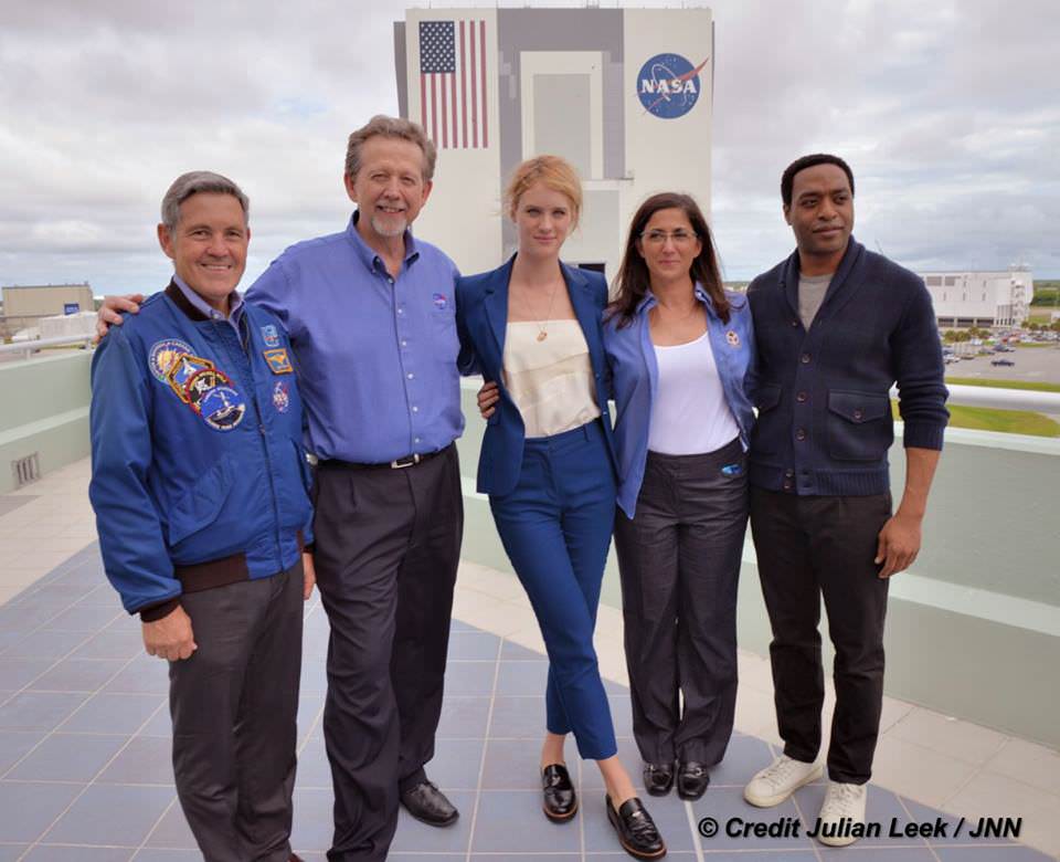
“NASA has endorsed “The Martian’” Jim Green, NASA’s Director of Planetary Sciences, told Universe Today. Green served as technical consultant on the film.
At NASA’s Kennedy Space Center in Florida agency scientists, astronauts actors from the 20th Century Fox Entertainment film “The Martian” met the media. Participants included, from the left, Center Director Bob Cabana, NASA’s Planetary Science Division Director Jim Green, Ph.D., actress Mackenzie Davis, who portrays Mindy Park in the movie, retired NASA astronaut Nicole Stott and actor Chiwetel Ejiofor, who portrays Vincent Kapoor in “The Martian.” Credit: Julian Leek
The DLR film was created by a team led by Ralf Jaumann from the DLR Institute of Planetary Research, Principal Investigator for HRSC. He believes that producing the overflight video was not just a gimmick for a science fiction film:
“Mars generates immense fascination, and our curiosity continues to grow! Many people are interested in our research, and young people in particular want to know what it is really like up there, and how realistic the idea that one day people will leave their footprints on the surface of Mars truly is. The data acquired by HRSC shows Mars with a clarity and detail unmatched by any other experiment. Only images acquired directly on the surface, for instance by rovers like Curiosity, are even closer to reality, but they can only show a small part of the planet. Thanks to this animation, we have even noticed a few new details that we had not seen in a larger spatial context. That is why we made the film – it helps everyone see what it would be like for Watney to travel through these areas… the clouds were the only creative touches we added, because, fortunately, they do not appear in the HRSC data,” according to a DLR statement.
Here’s the second official trailer for The Martian:
As a scientist and just plain Earthling, my most fervent hope is that ‘The Martian’ will inspire our young people to get interested in all fields of science, math and engineering and get motivated to become the next generation of explorers – here on Earth and beyond to the High Frontier to benefit all Mankind.
Stay tuned here for Ken’s continuing Earth and planetary science and human spaceflight news.
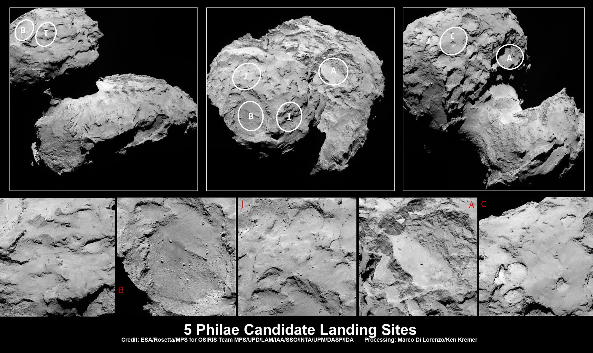
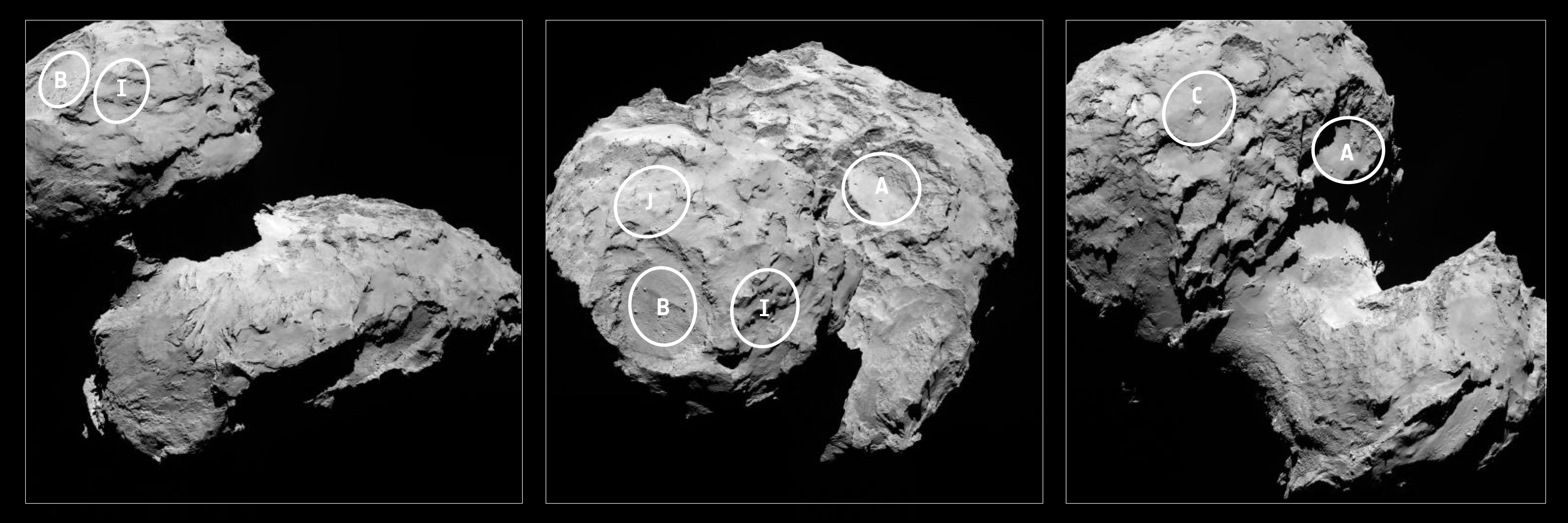
Five candidate sites were identified on Comet 67P/Churyumov-Gerasimenko for Rosetta’s Philae lander. The approximate locations of the five regions are marked on these OSIRIS narrow-angle camera images taken on 16 August 2014 from a distance of about 100 km. Enlarged insets below highlight 5 landing zones. Credits: ESA/Rosetta/MPS for OSIRIS Team MPS/UPD/LAM/IAA/SSO/INTA/UPM/DASP/IDA Processing: Marco Di Lorenzo/Ken Kremer
Five candidate sites were identified on Comet 67P/Churyumov-Gerasimenko for Rosetta’s Philae lander. The approximate locations of the five regions are marked on these OSIRIS narrow-angle camera images taken on 16 August 2014 from a distance of about 100 km. Enlarged insets below highlight 5 landing zones. Credits: ESA/Rosetta/MPS for OSIRIS Team MPS/UPD/LAM/IAA/SSO/INTA/UPM/DASP/IDA Processing: Marco Di Lorenzo/Ken Kremer
Story updated[/caption]
The ‘Top 5’ landing site candidates have been chosen for the Rosetta orbiters piggybacked Philae lander for humankind’s first attempt to land on a comet. See graphics above and below.
The potential touchdown sites were announce today, Aug. 25, based on high resolution measurements collected by ESA’s Rosetta spacecraft over the past two weeks since arriving at the bizarre and pockmarked Comet 67P/Churyumov-Gerasimenko on Aug. 6, 2014.
Rosetta is a mission of many firsts, including history’s first ever attempt to orbit a comet for long term study.
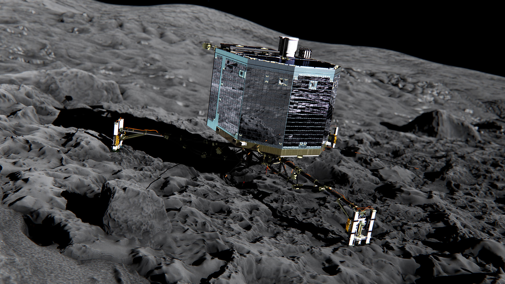
Philae’s history making landing on comet 67P is currently scheduled for around Nov. 11, 2014, and will be entirely automatic. The 100 kg lander is equipped with 10 science instruments.
“This is the first time landing sites on a comet have been considered,” said Stephan Ulamec, Lander Manager at DLR (German Aerospace Center), in an ESA statement.
Artist impression of Philae on the surface of comet 67P/Churyumov-Gerasimenko. Credit: ESA/ATG medialab
Since rendezvousing with the comet after a decade long chase of over 6.4 billion kilometers (4 Billion miles), a top priority task for the science and engineering team leading Rosetta has been “Finding a landing strip” for the Philae comet lander.
“The challenge ahead is to map the surface and find a landing strip,” said Andrea Accomazzo, ESA Rosetta Spacecraft Operations Manager, at the Aug. 6 ESA arrival live webcast.
So ‘the clock is ticking’ to select a suitable landing zone soon as the comet warms up and the surface becomes ever more active as it swings in closer to the sun and makes the landing ever more hazardous.
This past weekend, the site selection team met at CNES, Toulouse, France, and intensively discussed and scrutinized a preliminary list of 10 potential sites, and whittled that down to the ‘Top 5.’
Their goal was to find a ‘technically feasible’ touchdown site that was both safe and scientifically interesting.
“The site must balance the technical needs of the orbiter and lander during all phases of the separation, descent, and landing, and during operations on the surface with the scientific requirements of the 10 instruments on board Philae,” said ESA.
They also had to be within an ellipse of at least 1 square kilometer (six-tenths of a square mile) in diameter due to uncertainties in navigation as well as many other factors.
“For each possible zone, important questions must be asked: Will the lander be able to maintain regular communications with Rosetta? How common are surface hazards such as large boulders, deep crevasses or steep slopes? Is there sufficient illumination for scientific operations and enough sunlight to recharge the lander’s batteries beyond its initial 64-hour lifetime, while not so much as to cause overheating?” according to ESA.
Stephan Ulamec, Philae Lander Manager at DLR (German Aerospace Center) discusses landing during ESA webcast of Rosetta’s arrival at comet Comet 67P/Churyumov-Gerasimenko. Credit: ESA
The Landing Site Selection Group (LSSG) team was comprised of engineers and scientists from Philae’s Science, Operations and Navigation Centre (SONC) at CNES, the Lander Control Centre (LCC) at DLR, scientists representing the Philae Lander instruments as well as the ESA Rosetta team, which includes representatives from science, operations and flight dynamics.
“Based on the particular shape and the global topography of Comet 67P/ Churyumov-Gerasimenko, it is probably no surprise that many locations had to be ruled out,” said Ulamec.
“The candidate sites that we want to follow up for further analysis are thought to be technically feasible on the basis of a preliminary analysis of flight dynamics and other key issues – for example they all provide at least six hours of daylight per comet rotation and offer some flat terrain. Of course, every site has the potential for unique scientific discoveries.”
When Rosetta arrived on Aug. 6, it was initially orbiting at a distance of about 100 km (62 miles) in front of the comet. Carefully timed thruster firings then brought it to within about 80 km distance. And it is moving far closer – to within 50 kilometers (31 miles) and even closer!
Upon arrival the comet was 522 million km from the Sun. As Rosetta escorts the comet looping around the sun, they move much closer. By landing time in mid-November they are only about 450 million km (280 million mi) from the sun.
At closest approach on 13 August 2015 the comet and Rosetta will be 185 million km from the Sun. That corresponds to an eightfold increase in the light received from the Sun.
Five candidate sites were identified on Comet 67P/Churyumov-Gerasimenko for Rosetta’s Philae lander. The approximate locations of the five regions are marked on these OSIRIS narrow-angle camera images taken on 16 August 2014 from a distance of about 100 km. Credits: ESA/Rosetta/MPS for OSIRIS Team MPS/UPD/LAM/IAA/SSO/INTA/UPM/DASP/IDA
Therefore Rosetta and Philae will simultaneously study the warming effects of the sun as the comet outgases dust, water and much more.
The short period Comet 67P/Churyumov-Gerasimenko has an orbital period of 6.5 years.
“The comet is very different to anything we’ve seen before, and exhibits spectacular features still to be understood,” says Jean-Pierre Bibring, a lead lander scientist and principal investigator of the CIVA instrument.
“The five chosen sites offer us the best chance to land and study the composition, internal structure and activity of the comet with the ten lander experiments.”
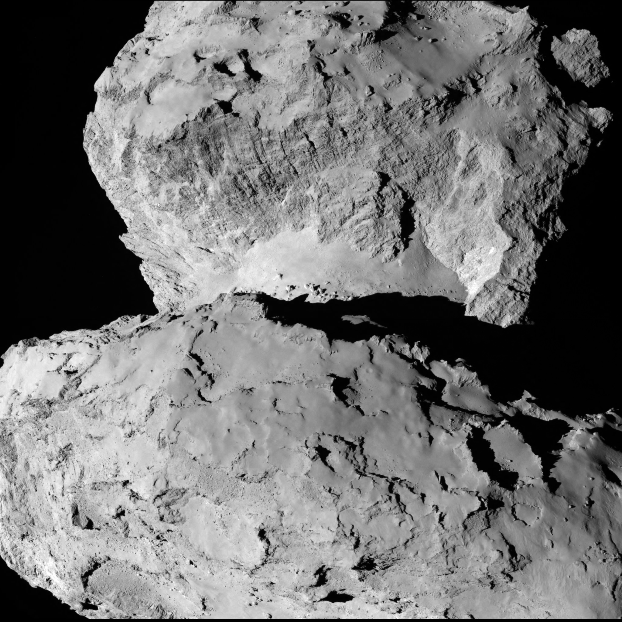
A close-up view of Comet 67P/Churyumov–Gerasimenko taken by the Rosetta spacecraft on Aug. 7, 2014. Credit: ESA/Rosetta/MPS for OSIRIS Team MPS/UPD/LAM/IAA/SSO/INTA/UPM/DASP/IDA
The ‘Top 5’ zones will be ranked by 14 September. Three are on the ‘head’ and two are on the ‘body’ of the bizarre two lobed alien world.
And a backup landing site will also be chosen for planning purposes and to develop landing sequences.
The ultimate selection of the primary landing site is slated for 14 October after consultation between ESA and the lander team on a “Go/No Go” decision.
The three-legged lander will fire two harpoons and use ice screws to anchor itself to the 4 kilometer (2.5 mile) wide comet’s surface. Philae will collect stereo and panoramic images and also drill 23 centimeters into and sample its incredibly varied surface.
Why study comets?
Comets are leftover remnants from the formation of the solar system. Scientists believe they delivered a vast quantity of water to Earth. They may have also seeded Earth with organic molecules – the building blocks of life as we know it.
Any finding of organic molecules will be a major discovery for Rosetta and ESA and inform us about the origin of life on Earth.
Read an Italian language version of this story by my imaging partner Marco Di Lorenzo – here
Stay tuned here for Ken’s continuing Earth and Planetary science and human spaceflight news.
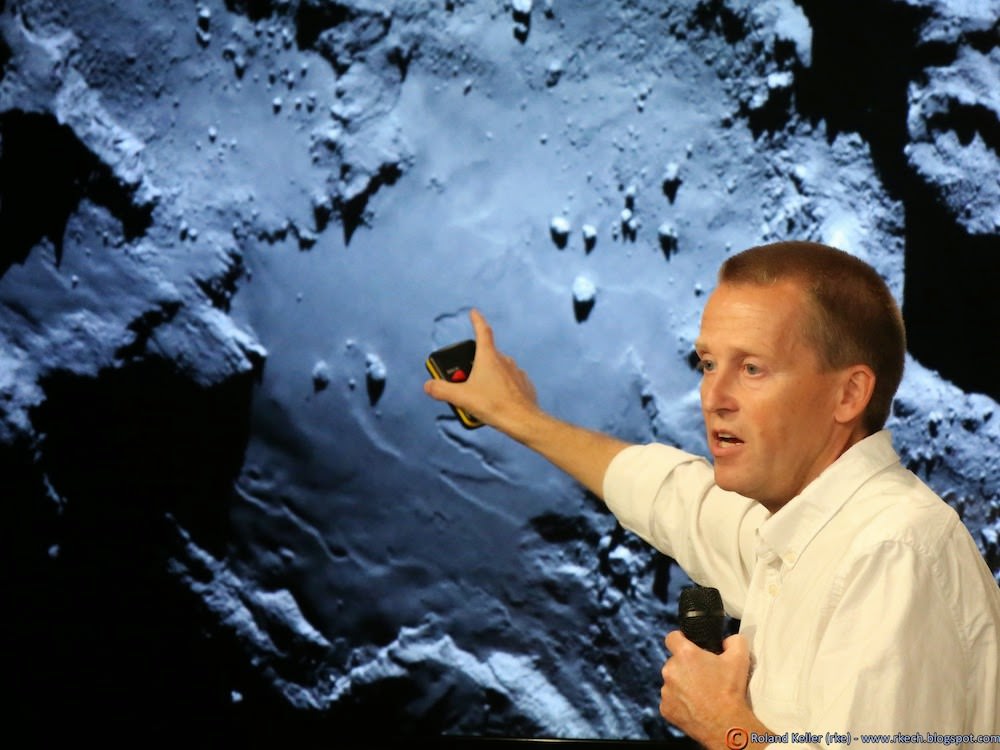
Holger Sierks, OSIRIS principal investigator, discusses spectacular hi res comet images returned so far by Rosetta during the Aug. 6 ESA webcast from mission control at ESOC, Darmstadt, Germany. Credit: Roland Keller
ESA’s Rosetta Spacecraft nears final approach to Comet 67P/Churyumov-Gerasimenko in late July 2014. This collage of imagery from Rosetta combines Navcam camera images at right taken nearing final approach from July 25 (3000 km distant) to July 31, 2014 (1327 km distant), with OSIRIS wide angle camera image at left of comet’s expanding coma cloud on July 25. Images to scale and contrast enhanced to show further detail. Credit: ESA/Rosetta/NAVCAM/OSIRIS/MPS/UPD/LAM/IAA/SSO/INTA/UPM/DASP/IDA Collage/Processing: Marco Di Lorenzo/Ken Kremer
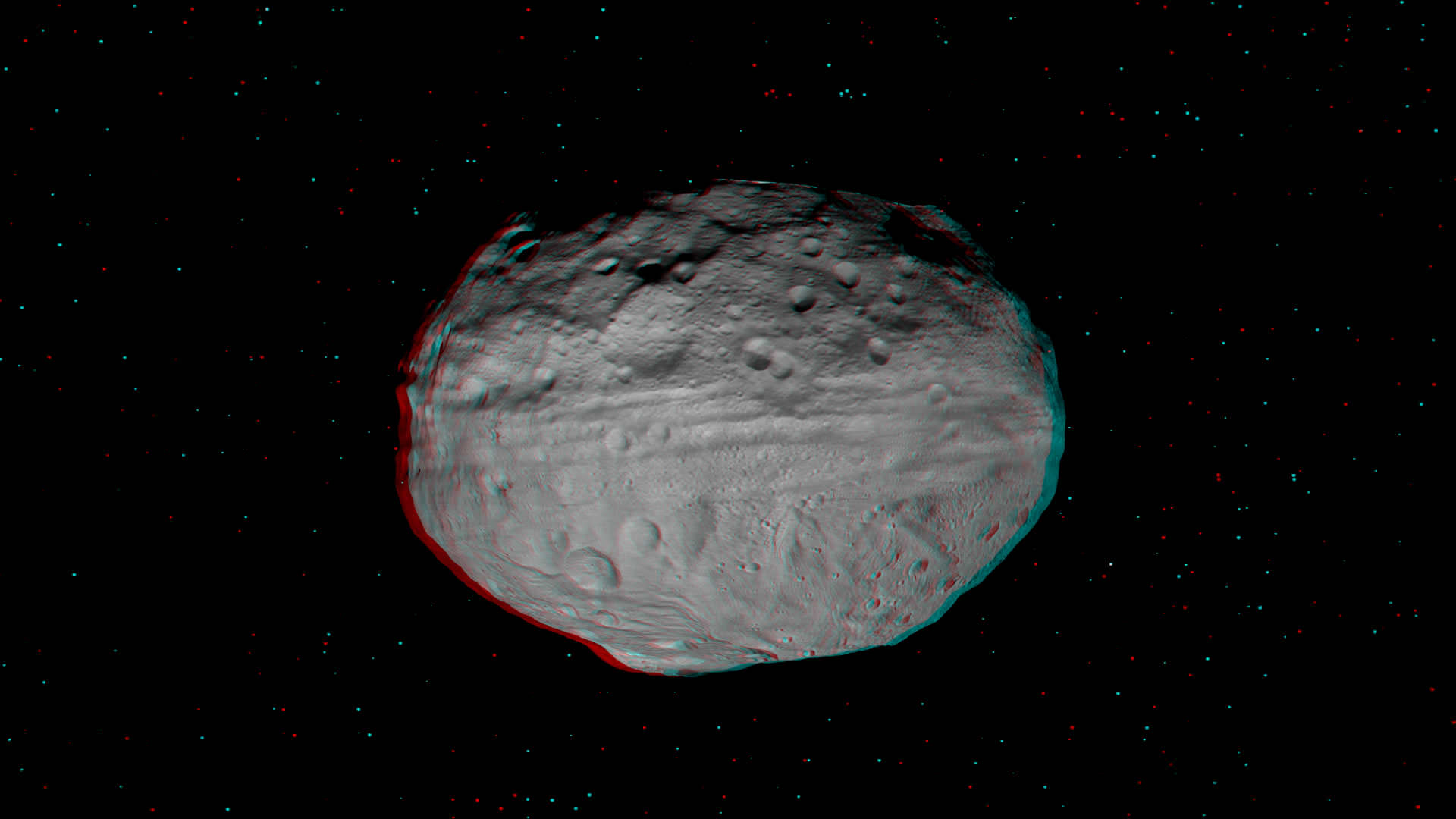
Vesta’s Eastern Hemisphere Floats in Space in 3-D. This anaglyph shows the varied topography of Vesta’s eastern hemisphere from craters in the north, the equatorial troughs and the huge mountain at the Souh Pole. Credit: NASA/JPL-Caltech/UCLA/MPS/DLR/IDA.
[/caption]
The giant Asteroid Vesta literally floats in space in a new high resolution 3-D image of the battered bodies Eastern Hemisphere taken by NASA’s Dawn Asteroid Orbiter.
Haul out your red-cyan 3-D anaglyph glasses and lets go whirling around Vesta and sledding down mountains to greet the alien Snowman! The sights are fabulous !
The Dawn imaging group based at the German Aerospace Center (DLR), in Berlin, Germany and led by team member Ralf Jaumann has released a trio of new high resolution 3-D images that are the most vivid anaglyphs yet published by the international science team.
The lead anaglyph shows the highly varied topography of the Eastern Hemisphere of Vesta and was taken during the final approach phase as Dawn was about 5,200 kilometers (3,200 miles) away and preparing to achieve orbit in July 2011.
The heavily cratered northern region is at top and is only partially illuminated because of Vesta’s tilted angle to the Sun at that time of year. Younger craters are overlain onto many older and more degraded craters. The equatorial region is dominated by the mysterious troughs which encircle most of Vesta and may have formed as a result of a gargantuan gong, eons ago.
The southern hemisphere exhibits fewer craters than in the northern hemisphere. Look closely at the bottom left and you’ll see the huge central mountain complex of the Rheasilvia impact basin visibly protruding out from Vesta’s south polar region.
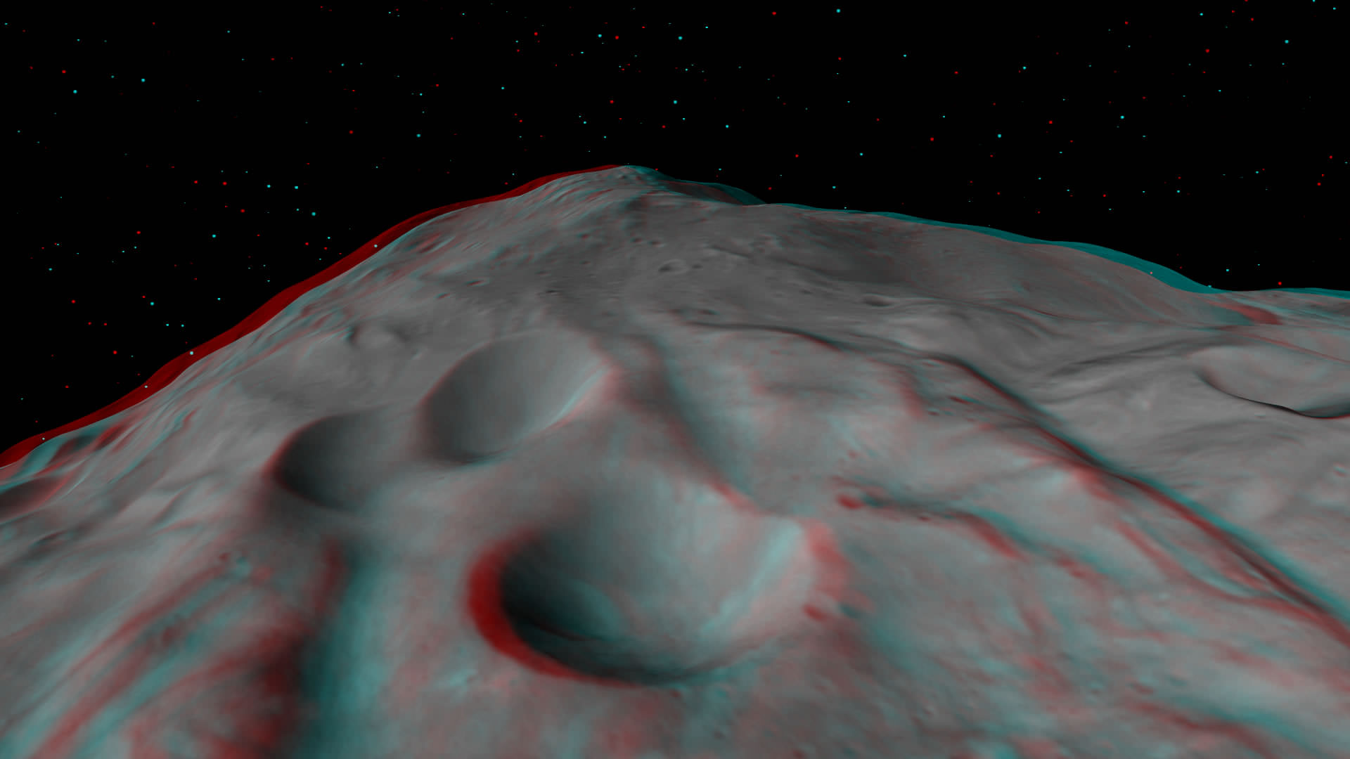
This next 3-D image shows a close-up of the South Pole Mountain at the center of the Rheasilvia Impact basin otherwise known as the “Mount Everest of Vesta”.
The Mount Everest of Vesta in 3-D
This anaglyph shows the central complex and huge mountain in Vesta’s Rheasilvia impact basin at the South Pole. Does water ice lurk beneath the South Pole ?
Credit: NASA/JPL-Caltech/UCLA/MPS/DLR/IDA.
The central complex is approximately 200 kilometers (120 miles) in diameter and is approximately 20 kilometers (12 miles) tall and is therefore about two and a half times taller than Earth’s Mount Everest!
Be sure to take a long look inside the deep craters and hummocky terrain surrounding “Mount Everest”.
A recent study concludes that, in theory, Vesta’s interior is cold enough for water ice to lurk beneath the North and South poles.
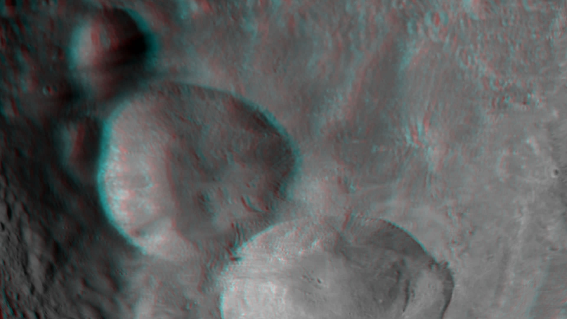
Finally lets gaze at the trio of craters that make up the “Snowman” in the 3-D image snapped in August 2011 as Dawn was orbiting at about 2,700 kilometers (1,700 miles) altitude. The three craters are named Minucia, Marcia and Calpurnia from top to bottom. Their diameters respectively are; 24 kilometers (15 miles), 53 kilometers (33 miles) and 63 kilometers (40 miles).
3-D image of Vesta’s “Snowman” craters
The three craters are named Minucia, Marcia and Calpurnia from top to bottom. They are 24 kilometers (15 miles), 53 kilometers (33 miles) and 63 kilometers (40 miles) in diameter, respectively. Image resolution is about 250 meters (820 feet) per pixel. Credit: NASA/JPL-Caltech/UCLA/MPS/DLR/IDA.
It is likely that Marcia and Calpurnia formed from the impact of a binary asteroid and that Minucia formed in a later impact. The smooth region around the craters is the ejecta blanket.
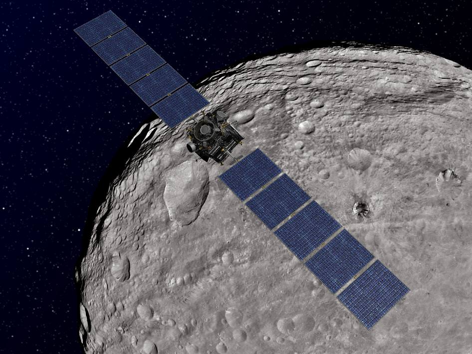
Dawn Orbiting Vesta above the “Snowman” craters
This artist's concept shows NASA's Dawn spacecraft orbiting the giant asteroid Vesta above the Snowman craters. The depiction of Vesta is based on images obtained by Dawn's framing cameras. Dawn is an international collaboration of the US, Germany and Italy. Credit: NASA/JPL-Caltech
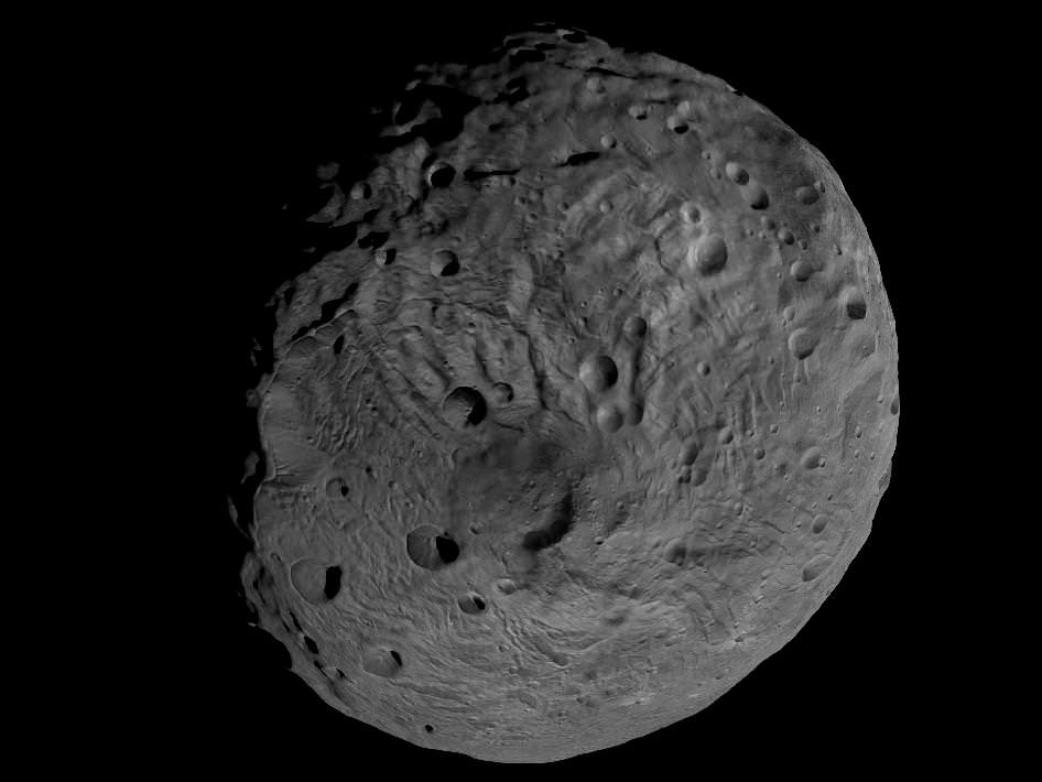
Vesta is the second most massive asteroid in the main Asteroid Belt between Mars and Jupiter. It is 330 miles (530 km) in diameter.
Dawn is the first spacecraft from Earth to visit Vesta. It achieved orbit in July 2011 for a year long mission. Dawn will fire up its ion propulsion thrusters in July 2012 to spiral out of orbit and sail to Ceres, the biggest asteroid of them all !
Vesta and Ceres are also considered to be protoplanets.
Viewing the South Pole of Vesta. This image obtained by Dawns framing camera and shows the south pole of the giant asteroid Vesta. Scientists are discussing whether the circular structure that covers most of this image originated by a collision with another asteroid, or by internal processes early in the asteroid's history. Images in higher resolution from Dawn's lowered orbit might help answer that question. The image was recorded from a distance of about 1,700 miles (2,700 kilometers). The image resolution is about 260 meters per pixel. Credit: NASA/JPL-Caltech/UCLA/MPS/DLR/IDA
Take us into orbit Mr. Sulu!
The Dawn science team has released two spectacular rotation movies of the entire globe of the giant asteroid Vesta. The flyover videos give the distinct impression that you are standing on the bridge of the Starship Enterprise and gazing at the view screen as the ship enters orbit about a new planet for the first time and are about to begin an exciting new journey of exploration and discovery of the body you’re looking at below.
Thanks to NASA, DLR, ASI and Dawn’s international science and engineering team, we can all join the away team on the expedition to unveil Vesta’s alluring secrets.
Click the start button and watch protoplanet Vesta’s striking surface moving beneath from the perspective of Dawn flying above – in the initial survey orbit at an altitude of 2700 kilometers (1700 miles). Vesta is the second most massive object in the main asteroid belt and Dawn’s first scientific conquest.
Another video below was compiled from images taken earlier on July 24, 2011 from a higher altitude after Dawn first achieved orbit about Vesta and revealed that the northern and southern hemispheres are totally different.
The array of images in the videos was snapped by Dawn’s framing camera which was provided by the German Aerospace Center (DLR). The team then created a shape model from the images, according to Dr. Carol Raymond, Dawn’s Deputy Principal Investigator from NASA’s Jet Propulsion Laboratory in Pasadena, Calif.
The shape model will aid in studying Vesta’s strikingly diverse features of mountains, ridges, valley’s, scarps, cliffs, grooves, craters, even a ‘snowman’ and much more.
Notice that not all of Vesta is illuminated – because it’s northern winter at the asteroid. Vesta has seasons like Earth and the northern polar region in now in perpetual darkness. Data is collected over the day side and radioed back to Earth over the night side.
“On Vesta right now, the southern hemisphere is facing the sun, so everywhere between about 52 degrees north latitude and the north pole is in a long night,” says Dr. Rayman, Dawn’s Chief Engineer from JPL. “That ten percent of the surface is presently impossible to see. Because Dawn will stay in orbit around Vesta as together they travel around the sun, in 2012 it will be able to see some of this hidden scenery as the seasons advance.”
Another movie highlight is a thorough look at the gigantic south pole impact basin. The circular feature is several hundred miles wide and may have been created by a cosmic collision eons ago that excavated massive quantities of material and basically left Vesta lacking a south pole.
[/caption]
The massive feature was discovered in images taken by the Hubble Space Telescope several years ago and mission scientists have been eager to study it up close in a way that’s only possible from orbit. Dawn’s three science instruments will investigate the south pole depression in detail by collecting high resolution images and spectra which may reveal the interior composition of Vesta.
Dawn entered the survey orbit on Aug. 11 and completed seven revolutions of 69 hours each on Sept. 1. It transmitted more than 2,800 pictures from the DLR framing camera covering the entire illuminated surface and also collected over three million visible and infrared spectra from the VIR spectrometer – provided by ASI, the Italian Space Agency. This results exceeded the mission objectives.
The Dawn spacecraft is now spiraling down closer using its ion propulsion system to the next mapping orbit – known as HAMO – four times closer than the survey orbit and only some 680 km (420 miles) above the surface.