Video: Fly Over a Weird Landscape on Mars in 3-D

Hydraotes Chaos is a typical example of ‘chaotic terrain.’ This large basin lies in the Martian highlands, near the equator. Credit: ESA.

This isn’t quite like Luke’s trench run in the Battle of Yavin, but it’s waaay more awesome in that this is real.

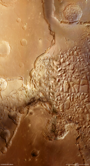
Go grab your red–green or red–blue 3-D glasses (you always have a pair right by your desk, right?) and enjoy this great flyover video from ESA showcasing some very interesting landforms on Mars that planetary geologists refer to as ‘chaotic terrain.’ There’s nothing quite like this on Earth, and scattered throughout a large area to both the west and east of Valles Marineris are hundreds of isolated mountains up to 2,000 meters high. “Seen from orbit, they form a bizarre, chaotic pattern,” say scientists from the Mars Express orbiter.

What created this weird landscape? Scientists think that during Mars’ early history, water in the form of ice was stored in cavities beneath the surface of the highlands; this was then heated and thawed out. It was then placed under so much pressure that it escaped to the surface with great force through fissures and fault zones. As it flowed out, the water eroded the terrain and gradually left behind the striking landscape visible today. Another factor supporting this theory is that many of the chaotic terrains on Mars are located at the head of large outflow channels, through which enormous quantities of water flowed out of the highlands towards the northern lowlands.

The data used to generate the images and the simulated flyover were acquired with the High Resolution Stereo Camera on ESA’s Mars Express orbiter.

See more imagery and details here.

Amazing Mars Flyover Videos Keep Getting Better and Better

How do the folks from UnmannedSpaceflight do it?!! They keep surpassing themselves with every new flyover video! We’ve posted some Mars flyover videos before, created by UMSF founder Doug Ellison. Now, colleague Adrian Lark — who has been working on creating animations and enhanced images with data from the Mars missions for several years — has produced new features on the videos. This latest, which flies you around the scarp surrounding Olympus Mons has speed and height information as well as a context map included on the video. “The data I am using is generated from the HiRISE camera onboard the Mars Reconnaissance Orbiter,” Adrian told me. “The elevation data has a spatial resolution of 1 meter and the image data has a spatial resolution of 25 centimeters. There is no vertical exaggeration in any of the videos.”

Also, Adrian has experimented with You Tube’s stereoscopic 3-D player, providing a 3-D experience of flying through Candor Chasma. IMAX, watchout! You’ve got competition!

So hang on while you watch these incredible videos! See more below, and also Adrian shared with me a little about his software and how he creates these flyover videos.
Continue reading “Amazing Mars Flyover Videos Keep Getting Better and Better”