The Moon's shadow is cast across Indonesia in this view from the DSCOVR spacecraft, March 9, 2016. (Courtesy of the DSCOVR EPIC team.)
On March 8, 2016 (March 9 local time) the Moon briefly blocked the light from the Sun in what was the only total solar eclipse of the year. The event was visible across portions of southeast Asia, Indonesia, and Micronesia, and was observed by both skywatchers on the ground in person and those watching live online around the world. While to most the view was of a silhouetted Moon slowly carving away the disk of the Sun before totality revealed a shimmering corona, the view from space looking back at Earth showed the Moon’s dark shadow passing over islands, clouds, and sea.
Earth rotates through an entire day as captured in this animation of 22 still images taken on Sept. 17, 2015 by NASA’s Earth Polychromatic Imaging Camera (EPIC) camera on the Deep Space Climate Observatory (DSCOVR) spacecraft. Credits: NASA
The EPIC camera, which stands for Earth Polychromatic Imaging Camera (EPIC), is located a million miles away on the DSCOVR real time space weather monitoring satellite and is designed to take full disk color images of the sunlit side of our home planet multiple times per day.
The EPIC NASA images are literally just a finger tip away, after a 17 year wait to get the satellite into the launch queue since it was first proposed by former VP Al Gore. They are all easily viewed at NASA’s new EPIC camera website which went online today, Monday, October 19, 2015.
This EPIC image was taken on Oct.17 and shows the Australian continent and a portion of Asia.
EPIC image taken on Oct. 17, 2015 showing the continent of Australia and a portion of Asia. Credit: NASA
An annotated guide map illustration identifying the visible land masses accompanies each EPIC image and follows along as the Earth rotates daily.
What a great geography learning tool for student classrooms worldwide!
Annotated guide map identifying the visible land masses accompanies each EPIC image. Credit: NASA
DSCOVR is a joint mission between NOAA, NASA, and the U.S Air Force (USAF) that is managed by NOAA. The satellite and science instruments were provided by NASA and NOAA.
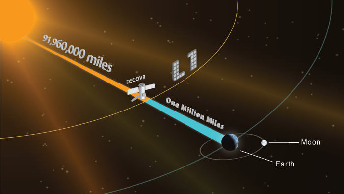
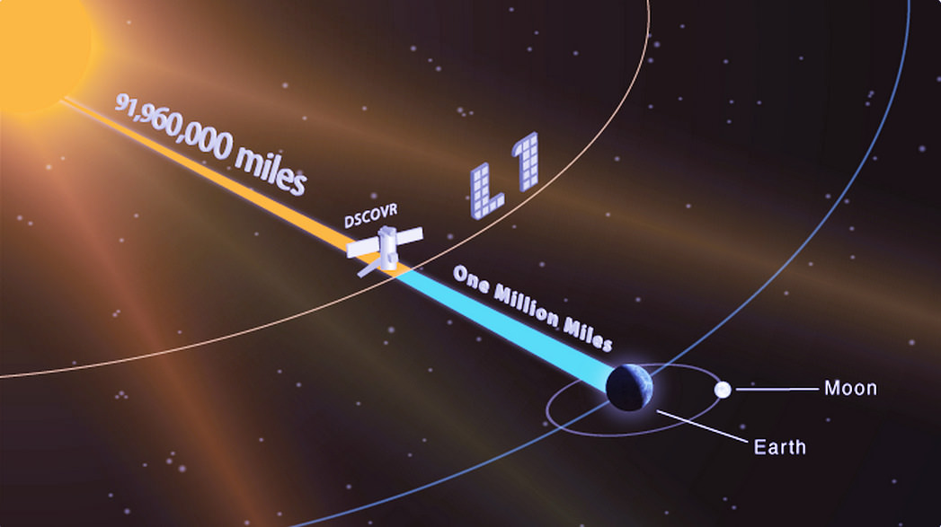
EPIC is a four megapixel CCD camera and telescope mounted on DSCOVR and orbiting around the L1 Lagrange Point – a neutral gravity point that lies on the direct line between Earth and the sun.
NASA says that once per day they will post “at least a dozen new color images of Earth acquired from 12 to 36 hours earlier” taken by the agency’s EPIC camera. The EPIC images will be stored in an archive searchable by date and continent.
The image sequence will show “the Earth as it rotates, thus revealing the whole globe over the course of a day.”
“The effective resolution of the DSCOVR EPIC camera is somewhere between 6.2 and 9.4 miles (10 and 15 kilometers),” said Adam Szabo, DSCOVR project scientist at NASA’s Goddard Space Flight Center, Greenbelt, Maryland, in a statement.
“The color Earth images are created by combining three separate single-color images to create a photographic-quality image equivalent to a 12-megapixel camera. The camera takes a series of 10 images using different narrowband filters — from ultraviolet to near infrared — to produce a variety of science products. The red, green and blue channel images are used to create the color images. Each image is about 3 megabytes in size.”
EPIC will capture “a constant view of the fully illuminated Earth as it rotates, providing scientific observations of ozone, vegetation, cloud height and aerosols in the atmosphere.”
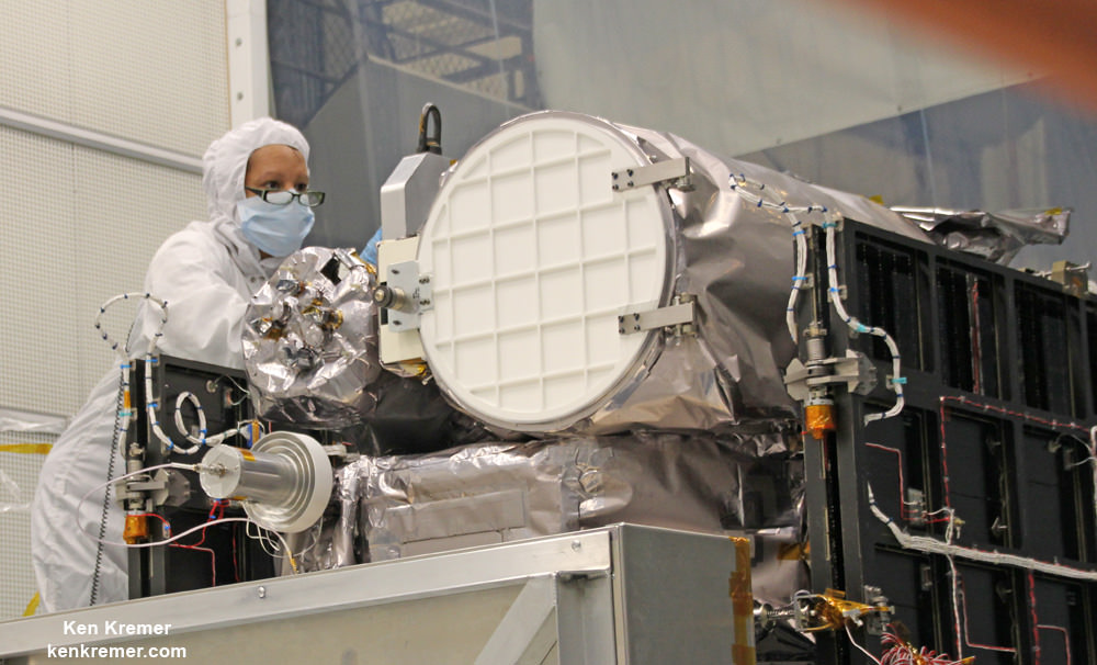
Technician works on NASA Earth science instruments and Earth imaging EPIC camera (white circle) housed on NOAA/NASA Deep Space Climate Observatory (DSCOVR) inside NASA Goddard Space Flight Center clean room in November 2014. Credit: Ken Kremer/kenkremer.com
The couch sized probe was launched atop a SpaceX Falcon 9 on Feb. 11, 2015 from Cape Canaveral, Florida, to start the million mile journey to its deep space observation post at L1. The rocket was funded by the USAF.
The primary goal of the $340 million DSCOVR satellite is to monitor the solar wind and aid very important forecasts of space weather at Earth from L1.
L1 is located 1.5 million kilometers (932,000 miles) sunward from Earth. At L1 the gravity between the sun and Earth is perfectly balanced and the DSCOVR satellite orbits about that spot just like a planet.
The mission is vital because its solar wind observations are crucial to maintaining accurate space weather forecasts to protect US infrastructure such as power grids, aviation, planes in flight, all types of Earth orbiting satellites for civilian and military needs, telecommunications, ISS astronauts and GPS systems.
This animation shows images of the far side of the moon, illuminated by the sun, as it crosses between the DISCOVR spacecraft’s Earth Polychromatic Imaging Camera (EPIC) camera and telescope, and the Earth – one million miles away. Credit: NASA/NOAA
DSCOVR was first proposed in 1998 by then US Vice President Al Gore as the low cost ‘Triana’ satellite to take near continuous views of the Earth’s entire globe to feed to the internet as a means of motivating students to study math and science.
It was also dubbed “Goresat.”
The probe was eventually resurrected and partially rebuilt at NASA Goddard Space Flight Center as a much more capable Earth science satellite that would also conduct the space weather observations.
But Triana was shelved for purely partisan political reasons and the satellite was placed into storage at NASA Goddard.
Thus the practical and teachable science and daily scenes of the gorgeously rotating Earth were lost – until now!
Former VP Al Gore was clearly delighted with today’s launch of NASA’s EPIC website in this pair of tweets:
“Today @NASA launched its site for #DSCOVR’s daily images. I look forward to seeing more from #DSCOVR,” tweeted Al Gore.
“DSCOVR’s site displaying new daily images of Earth from L1 was launched today! Congratulations to all those who made this happen!”
Stay tuned here for Ken’s continuing Earth and planetary science and human spaceflight news.
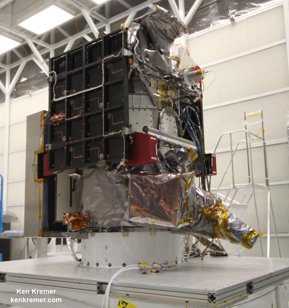
NOAA/NASA Deep Space Climate Observatory (DSCOVR) undergoes processing in NASA Goddard Space Flight Center clean room. Solar wind instruments at right. DSCOVER launched in February 2015 atop SpaceX Falcon 9 rocket. Credit: Ken Kremer/kenkremer.comNOAA/NASA/USAF Deep Space Climate Observatory (DSCOVR) undergoes processing in NASA Goddard Space Flight Center clean room. Probe launched in February 2015 atop SpaceX Falcon 9 rocket. Credit: Ken Kremer/kenkremer.com
This animation shows images of the far side of the moon, illuminated by the sun, as it crosses between the DISCOVR spacecraft's Earth Polychromatic Imaging Camera (EPIC) camera and telescope, and the Earth - one million miles away. Credit: NASA/NOAA
This animation shows images of the far side of the moon, illuminated by the sun, as it crosses between the DISCOVR spacecraft’s Earth Polychromatic Imaging Camera (EPIC) camera and telescope, and the Earth – one million miles away. Credit: NASA/NOAA
See YouTube version and EPIC camera below[/caption]
An eye-poppingly ‘EPIC’ view of the sunlit far side of the Moon transiting the sunlit side of Earth was recently captured by NASA’s Earth Polychromatic Imaging Camera (EPIC) camera from one million miles away. “Wow!” – is an understatement!
The stunning animation of the Moon crossing in front of the Earth, shown above, and seemingly unlike anything else, was created from a series of images taken in July by NASA’s EPIC camera flying aboard the orbiting Deep Space Climate Observatory (DSCOVR), a space weather monitoring satellite, according to a NASA statement.
Have just witnessed NASA’s New Horizons flyby of the Pluto-Charondouble planet system, the similarity to what some call the Earth-Moon double planet system is eerie. You could imagine ones heart going out to Earth’s Australian continent as an upside down version of Pluto’s bright heart shaped ‘Tombaugh Regio’ region in the southern hemisphere.
EPIC is a four megapixel CCD camera and telescope mounted on DSCOVR and orbiting at the L1 Lagrange Point – a neutral gravity point that lies on the direct line between Earth and the sun.
The goal of the $340 million DSCOVR is to monitor the solar wind and aid very important forecasts of space weather at Earth from L1.
EPIC will capture “a constant view of the fully illuminated Earth as it rotates, providing scientific observations of ozone, vegetation, cloud height and aerosols in the atmosphere.”
L1 is located 1.5 million kilometers (932,000 miles) sunward from Earth. At L1 the gravity between the sun and Earth is perfectly balanced and the DSCOVR satellite orbits about that spot just like a planet.
The EPIC images “were taken between 3:50 p.m. and 8:45 p.m. EDT on July 16, showing the moon moving over the Pacific Ocean near North America,” NASA said.
This image shows images of the far side of the moon, illuminated by the sun, as it crosses between the DISCOVR spacecraft’s Earth Polychromatic Imaging Camera (EPIC) camera and telescope, and the Earth – one million miles away. Credits: NASA/NOAA
You can see Earth’s North Pole at the upper left side of the images which results from the orbital tilt of Earth from the vantage point of the spacecraft at the L1 Lagrange Point.
EPIC will take full disk color images of the sunlit side of Earth at least six times per day.
They will be made publically available by NASA at a dedicated website, when the camera starts its regular daily science observation campaign of the home planet in about a month during September.
NASA says the images will show varying views of the rotating Earth and they will be posted online some 12 to 36 hours after they are acquired.
Each image is actually a composite of three images taken in the red, green and blue channels of the EPIC camera to provide the final “natural color” image of Earth. Since the images are taken about 30 seconds apart as the moon is moving there is a slight but noticeable artifact on the right side of the moon, NASA explained.
Altogether, “ EPIC takes a series of 10 images using different narrowband spectral filters — from ultraviolet to near infrared — to produce a variety of science products. The red, green and blue channel images are used in these color images.”
EPIC should capture these Earth-Moon transits about twice per year as the orbit of DSCOVR crosses the orbital plane of the moon.
The closest analog according to NASA came in May 2008 when NASA’s Deep Impact spacecraft “captured a similar view of Earth and the moon from a distance of 31 million miles away. The series of images showed the moon passing in front of our home planet when it was only partially illuminated by the sun.”
We never see the far side of the moon from Earth since the bodies are tidally locked. And its quite apparent from the images, that the moon’s far side looks completely different from the side facing Earth. The far side lacks the large, dark, basaltic plains, or maria, that are so prominent on the Earth-facing side.
“It is surprising how much brighter Earth is than the moon,” said Adam Szabo, DSCOVR project scientist at NASA’s Goddard Space Flight Center in Greenbelt, Maryland, in a statement.
“Our planet is a truly brilliant object in dark space compared to the lunar surface.”
DSCOVR is a joint mission between NOAA, NASA, and the U.S Air Force (USAF) that is managed by NOAA. The satellite and science instruments were provided by NASA and NOAA.
Technician works on NASA Earth science instruments and Earth imaging EPIC camera (white circle) housed on NOAA/NASA Deep Space Climate Observatory (DSCOVR) inside NASA Goddard Space Flight Center clean room in November 2014. Credit: Ken Kremer/kenkremer.com
DSCOVR was first proposed in 1998 by then US Vice President Al Gore as the low cost ‘Triana’ satellite to take near continuous views of the Earth’s entire globe to feed to the internet as a means of motivating students to study math and science. It was eventually built as a much more capable Earth science satellite that would also conduct the space weather observations.
But Triana was shelved for purely partisan political reasons and the satellite was placed into storage at NASA Goddard and the science was lost until now.
It was also dubbed “Goresat.’
Stay tuned here for Ken’s continuing Earth and planetary science and human spaceflight news.
Video caption: This animation shows images of the far side of the moon, illuminated by the sun, as it crosses between the DISCOVR spacecraft’s Earth Polychromatic Imaging Camera (EPIC) camera and telescope, and the Earth – one million miles away. Credit: NASA/NOAA
NOAA/NASA Deep Space Climate Observatory (DSCOVR) undergoes processing in NASA Goddard Space Flight Center clean room. Solar wind instruments at right. DSCOVER launched in February 2015 atop SpaceX Falcon 9 rocket. Credit: Ken Kremer/kenkremer.comLaunch of NOAA DSCOVR satellite from Cape Canaveral Air Force Station on Feb. 11, 2015 to monitor solar storms and space weather. Credit: Julian Leek
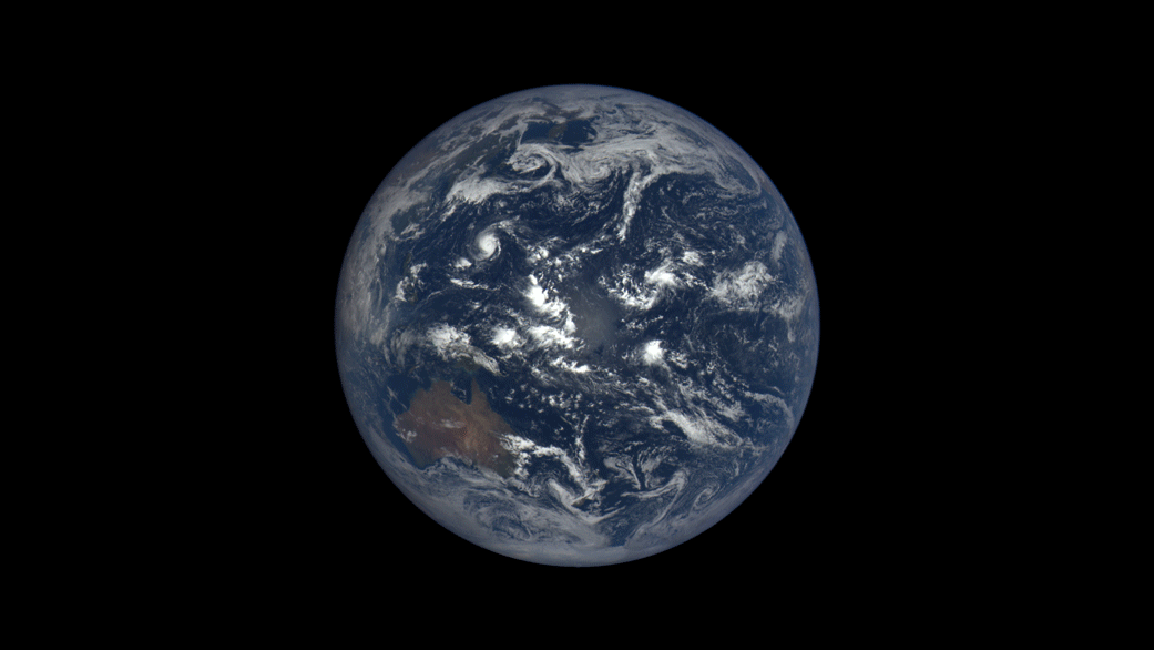
Earth imaged on July 6, 2015 by NOAA's DSCOVR satellite from L1. Credit: NOAA/NASA/GSFC
This picture of our home planet truly is EPIC – literally! The full-globe image was acquired with NASA’s Earth Polychromatic Imaging Camera (aka EPIC; see what they did there) on board NOAA’s DSCOVR spacecraft, positioned nearly a million miles (1.5 million km) away at L1.
L1 is one of five Lagrange points that exist in space where the gravitational pull between Earth and the Sun are sort of canceled out, allowing spacecraft to be “parked” there. (Learn more about Lagrange points here.) Launched aboard a SpaceX Falcon 9 on Feb. 11, 2015, the Deep Space Climate Observatory (DSCOVR) arrived at L1 on June 8 and, after a series of instrument checks, captured the image of Earth’s western hemisphere above on July 6.
The EPIC instrument has the capability to capture images in ten narrowband channels from infrared to ultraviolet; the true-color picture above was made from images acquired in red, green, and blue visible-light wavelengths.
More than just a pretty picture of our blue marble, this image will be used by the EPIC team to help calibrate the instrument to remove some of the blue atmospheric haze from subsequent images. Once the camera is fully set to begin operations daily images of our planet will be made available on a dedicated web site starting in September.
DSCOVR’s location at L1 (NOAA/NASA)
Designed to provide early warnings of potentially-disruptive geomagnetic storms resulting from solar outbursts, DSCOVR also carries Earth-observing instruments that will monitor ozone and aerosols in the atmosphere and measure the amount of energy received, reflected, and emitted by Earth – the planet’s “energy budget.”
But also, from its permanent location a million miles away, DSCOVR will be able to get some truly beautiful – er, EPIC – images of our world.
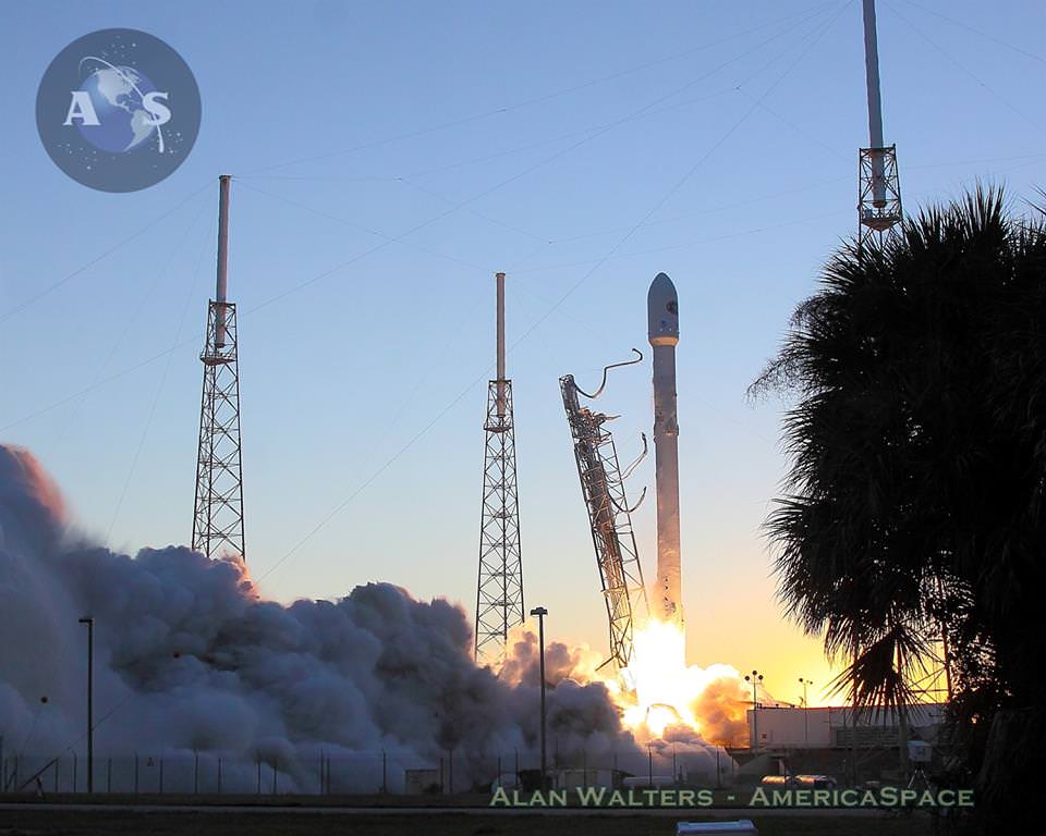
NOAA's DSCOVR satellite launches from Cape Canaveral Air Force Station on Feb. 11, 2015. DSCOVR will provide NOAA space weather forecasters more reliable measurements of solar wind conditions, improving their ability to monitor potentially harmful solar activity. Credit: Alan Walters/AmericaSpace
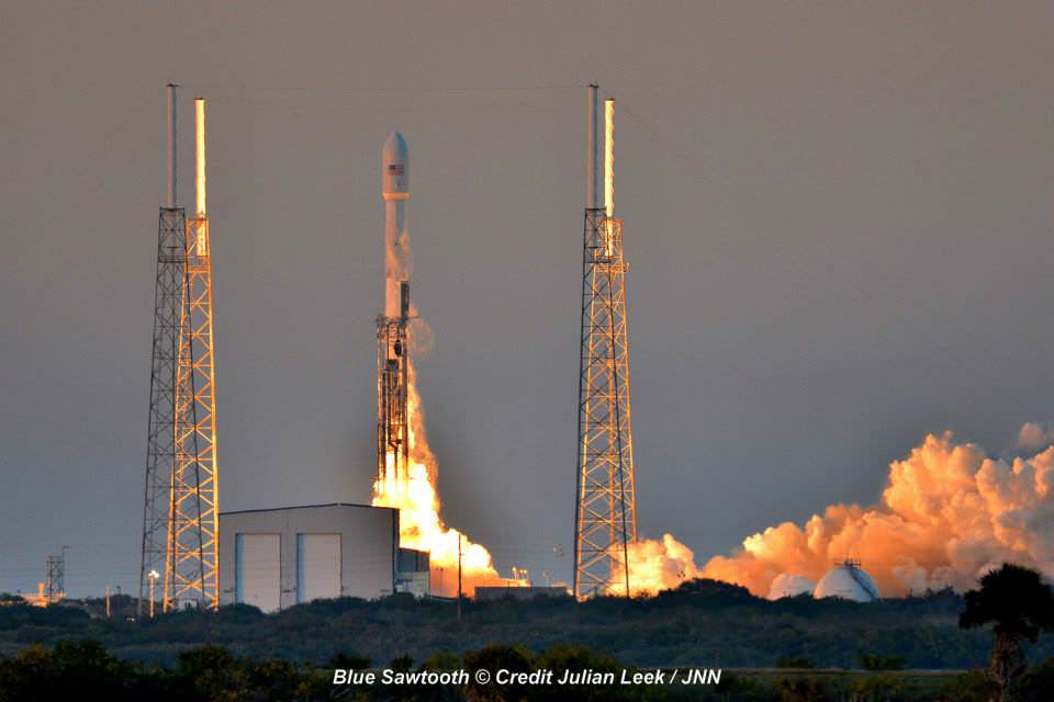
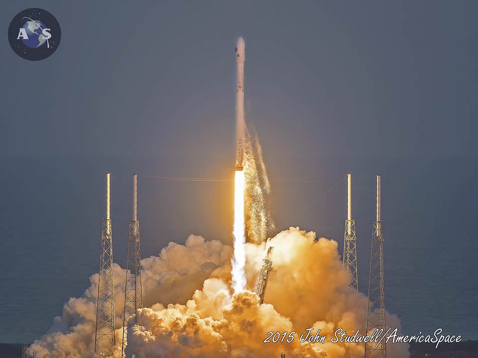
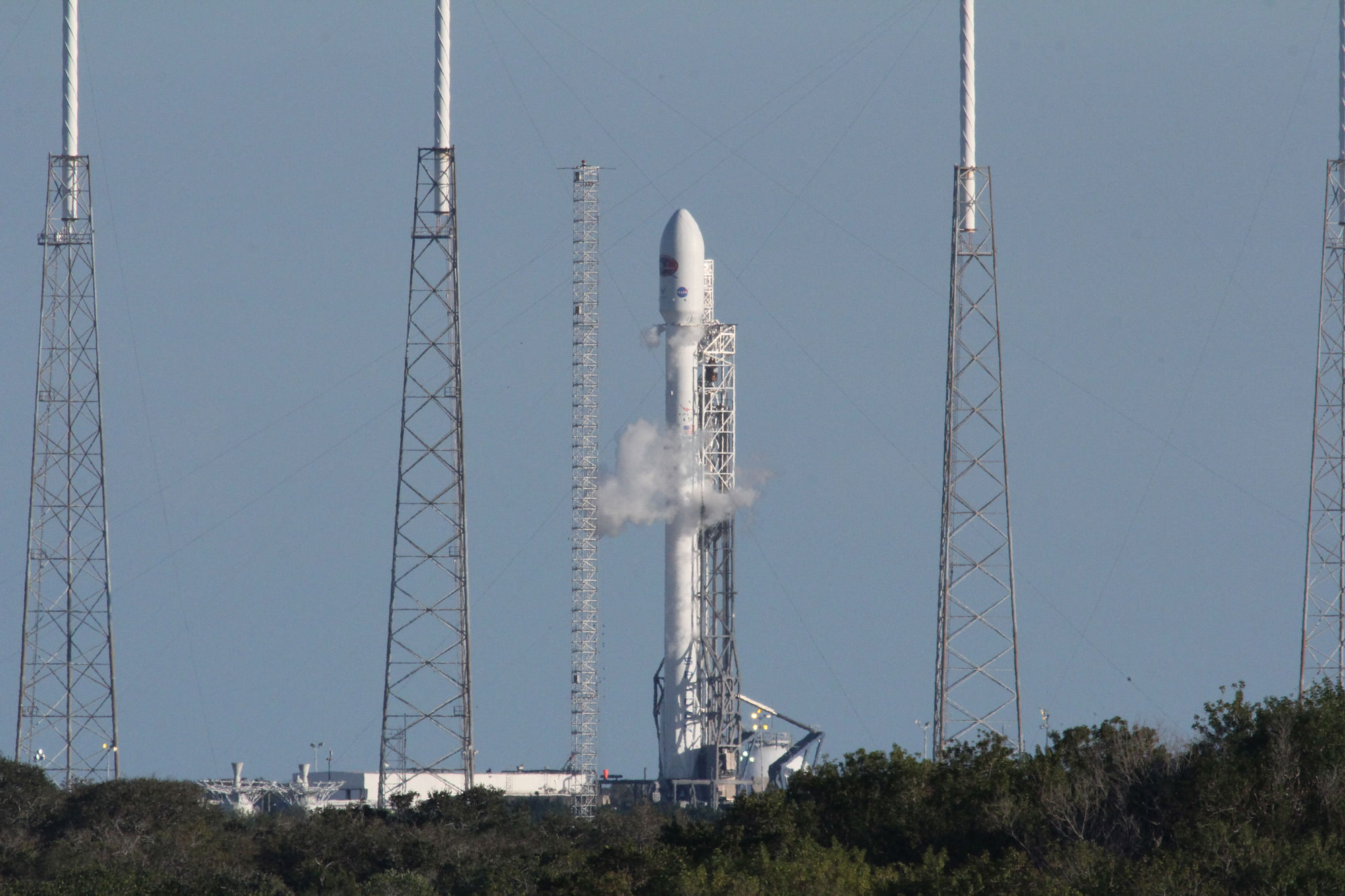
After a 17 year long wait, a new American mission to monitor intense solar storms and warn of impeding space weather disruptions to vital power grids, telecommunications satellites and public infrastructure was launched atop a SpaceXFalcon 9 on Wednesday, Feb. 11, from Cape Canaveral, Florida, to start a million mile journey to its deep space observation post.
The third time proved to be the charm when the Deep Space Climate Observatory, or DSCOVR science satellite lifted off at 6:03 p.m. EST Wednesday from Space Launch Complex 40 at Cape Canaveral Air Force Station in Florida.
The spectacular sunset blastoff came after two scrubs this week forced by a technical problem with the Air Force tracking radar and adverse weather on Sunday and Tuesday.
The $340 million DSCOVR has a critical mission to monitor the solar wind and aid very important forecasts of space weather at Earth at an observation point nearly a million miles from Earth. It will also take full disk color images of the sunlit side of Earth at least six times per day that will be publicly available and “wow” viewers.
Launch of NOAA DSCOVR satellite from Cape Canaveral Air Force Station on Feb. 11, 2015 to monitor solar storms and space weather. Credit: Julian Leek
The couch sized probe was targeted to the L1 Lagrange Point, a neutral gravity point that lies on the direct line between Earth and the sun located 1.5 million kilometers (932,000 miles) sunward from Earth. At L1 the gravity between the sun and Earth is perfectly balanced and the satellite will orbit about that spot just like a planet.
L1 is a perfect place for the science because it lies outside Earth’s magnetic environment. The probe will measure the constant stream of solar wind particles from the sun as they pass by.
The DSCOVR spacecraft (3-axis stabilized, 570 kg) will be delivered to the Sun-Earth L1 point, 1.5 million km (1 million miles) from the Earth, directly in front of the Sun. A Halo (Lissajous) orbit will stabilize the craft’s position around the L1 point while keeping it outside the radio noise emanating from the Sun. (Illustratin Credit: NASA)
DSCOVR is a joint mission between NOAA, NASA, and the U.S Air Force (USAF) that will be managed by NOAA. The satellite and science instruments are provided by NASA and NOAA. The rocket was funded by the USAF.
The mission is vital because its solar wind observations are crucial to maintaining accurate space weather forecasts to protect US infrastructure such as power grids, aviation, planes in flight, all types of Earth orbiting satellites for civilian and military needs, telecommunications, ISS astronauts and GPS systems.
It will take about 150 days to reach the L1 point and complete satellite and instrument checkouts.
DSCOVR will then become the first operational space weather mission to deep space and function as America’s primary warning system for solar magnetic storms.
It will replace NASA’s aging Advanced Composition Explorer (ACE) satellite which is nearly 20 years old and far beyond its original design lifetime.
“DSCOVR is the latest example of how NASA and NOAA work together to leverage the vantage point of space to both understand the science of space weather and provide direct practical benefits to us here on Earth,” said John Grunsfeld, associate administrator of NASA’s Science Mission Directorate in Washington.
DSCOVR was first proposed in 1998 by then US Vice President Al Gore as the low cost ‘Triana’ satellite to take near continuous views of the Earth’s entire globe to feed to the internet as a means of motivating students to study math and science. It was eventually built as a much more capable Earth science satellite that would also conduct the space weather observations.
But Triana was shelved for purely partisan political reasons and the satellite was placed into storage at NASA Goddard and the science was lost until now.
DSCOVR mission logo. Credit: NOAA/NASA/U.S. Air Force
DSCOVR is equipped with a suite of four continuously operating solar science and Earth science instruments from NASA and NOAA.
It will make simultaneous scientific observations of the solar wind and the entire sunlit side of Earth.
The 750-kilogram (1250 pound) DSCOVR probe measures 54 inches by 72 inches.
Technician works on NASA Earth science instruments and Earth imaging EPIC camera (white circle) housed on NOAA/NASA Deep Space Climate Observatory (DSCOVR) inside NASA Goddard Space Flight Center clean room in November 2014. Credit: Ken Kremer/kenkremer.com/AmericaSpace
The two Earth science instruments from NASA are the Earth Polychromatic Imaging Camera (EPIC) and the National Institute of Standards and Technology Advanced Radiometer (NISTAR).
EPIC will provide true color spectral images of the entire sunlit face of Earth at least six times per day, as viewed from an orbit around L1. They will be publically available within 24 hours via NASA Langley.
It will view the full disk of the entire sunlit Earth from sunrise to sunset and collect a variety of science measurements including on ozone, aerosols, dust and volcanic ash, vegetation properties, cloud heights and more.
Listen to my post launch interview with the BBC about DSCOVR and ESA’s successful IXV launch on Feb. 11.
NOAA/NASA Deep Space Climate Observatory (DSCOVR) undergoes processing in NASA Goddard Space Flight Center clean room. Solar wind instruments at right. DSCOVER will launch in February 2015 atop SpaceX Falcon 9 rocket. Credit: Ken Kremer/kenkremer.com/AmericaSpaceLaunch of NOAA DSCOVR satellite from Cape Canaveral Air Force Station on Feb. 11, 2015 to monitor solar storms and space weather. Credit: John StudwellPrelaunch view of SpaceX rocket on Cape Canaveral launch pad taken from LC-39 at the Kennedy Space Center. Credit: Chuck Higgins