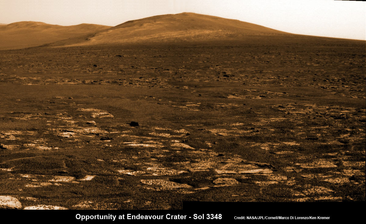
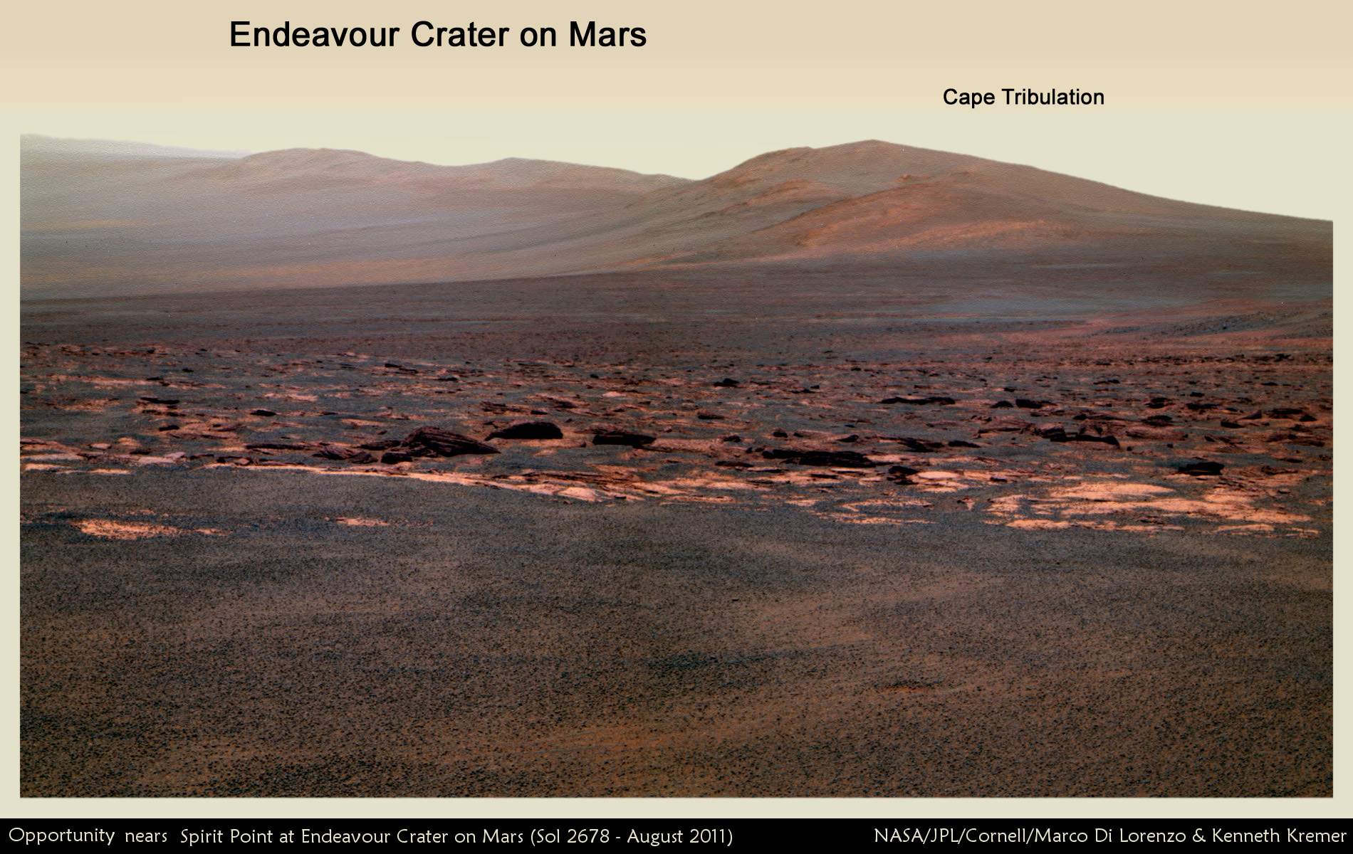
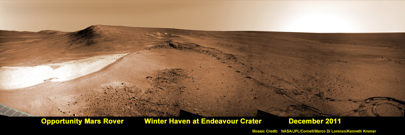
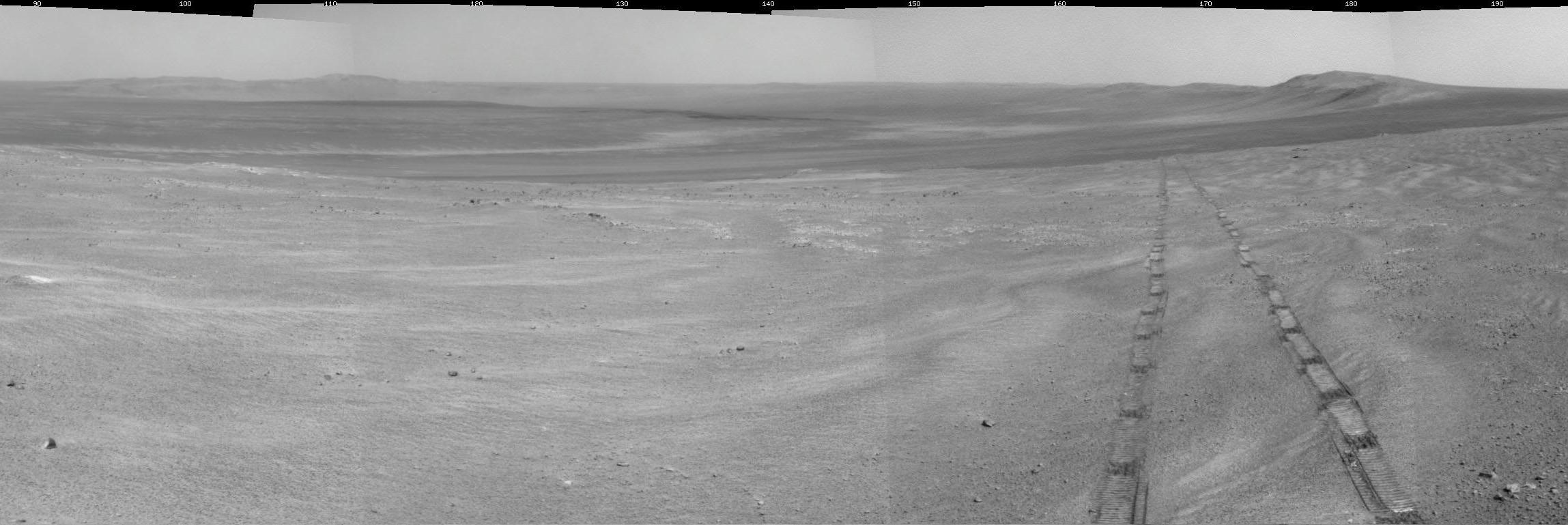
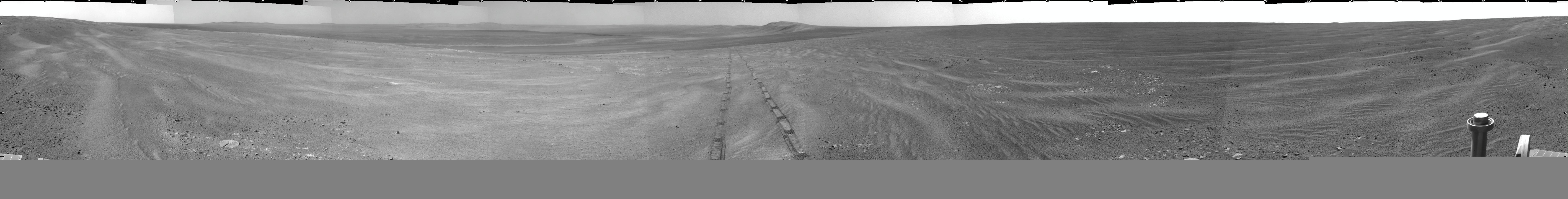
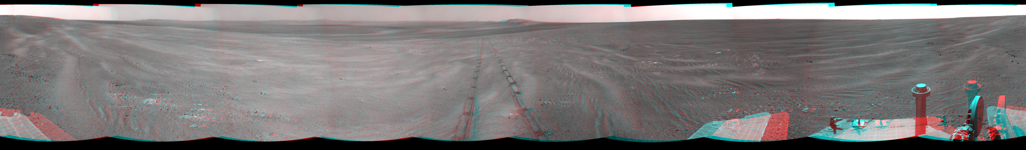
Opportunity rover’s view across Botany Bay to Solander Point - her next destination - as NASA celebrates 10 Years since blastoff for Mars on July 7, 2003. The rover will climb up Solander Point because it which may harbor clay minerals indicative of a past Martian habitable environment. This pancam mosaic was assembled from raw images taken on Sol 3348 (June 24, 2013. Credit: NASA/JPL/Cornell/ASU/Marco Di Lorenzo/Ken Kremer (kenkremer.com)
Opportunity rover’s view across Botany Bay to Solander Point – her next destination – as NASA celebrates 10 Years since blastoff for Mars on July 7, 2003. The rover will climb up Solander Point because it which may harbor clay minerals indicative of a past Martian habitable environment. This pancam mosaic was assembled from raw images taken on Sol 3348 (June 24, 2013.
Credit: NASA/JPL/Cornell/ASU/Marco Di Lorenzo/Ken Kremer (kenkremer.com)[/caption]
Today, NASA’sOpportunity rover marks a magical moment celebrating 10 years since launching to Mars on July 7, 2003 and with her impending Mountain destination filling the camera’s eye view.
The now legendary robot has vastly exceeded everyone’s expectations. Back in 2003 the science team promised us a mere 90 day ‘warranty’ following the suspenseful airbag landing on Jan. 24, 2004 at Meridiani Planum.
Today is Martian Day (or Sol) 3360. That amounts to a life expectancy and exploration ‘bonus’ of more than 37 times beyond the design lifetime.
Launch of NASA’s 2nd Mars Exploration Rover, Opportunity, aboard a Delta II Heavy rocket to Mars on July 7, 2003 at 11:18 p.m. EDT from Pad 17-B at Cape Canaveral Air Force Station, Fla. Credit: NASA
Opportunity’s twin sister Spirit blasted off three weeks earlier in June 2003 and continued functioning until 2010.
“I never thought we’d achieve nine months!” Principal Investigator Prof. Steve Squyres of Cornell University told me recently on the occasion of the rovers 9th anniversary on Mars in January 2013.
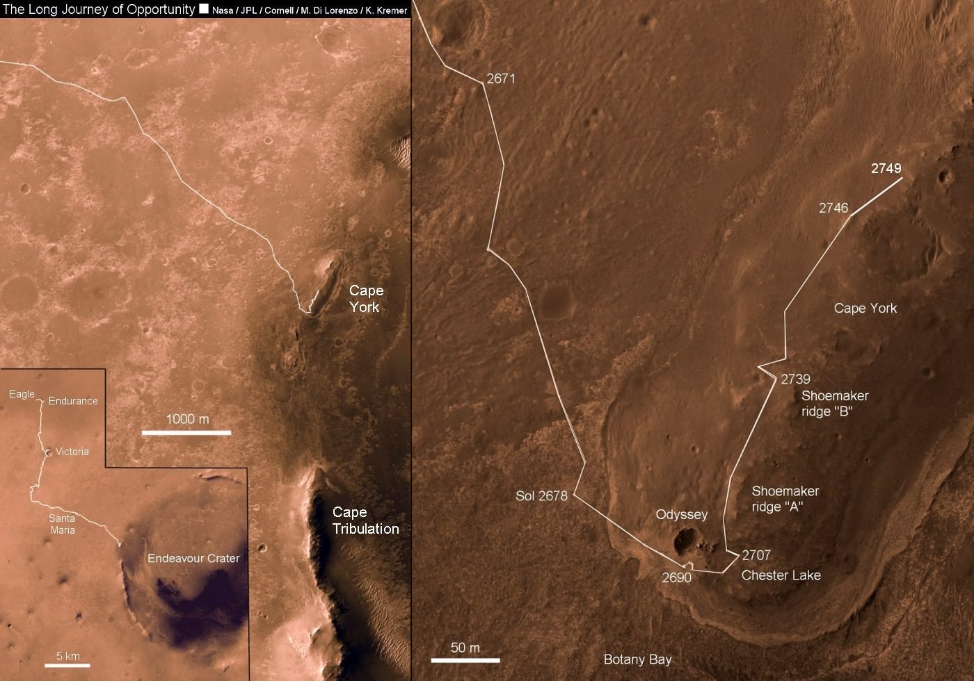
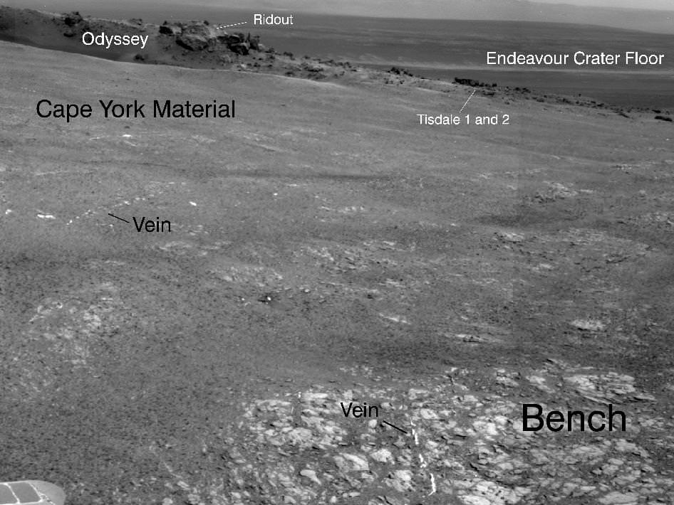
As you read this, the now decade old rover Opportunity is blazing a trail toward’s the oldest geological deposits she has ever explored – at a place called Solander Point, a raised ridge along the eroded rim of huge Endeavour Crater.
Opportunity has surpassed the halfway point in the traverse from the rim segment she has explored the past 22 months at ‘Cape York’ to her next rim segment destination at Solander.
From tip to tip, Cape York and Solander Point lie 1.2-mile (2-kilometer) apart along the western rim of Endeavour Crater. Both are raised portions of 14-mile-wide (22-kilometer-wide) Endeavour.
The rover has less than half a mile (800 meters) to go to finish the Martian dash from one rim segment to the next across an area called ‘Botany Bay’.
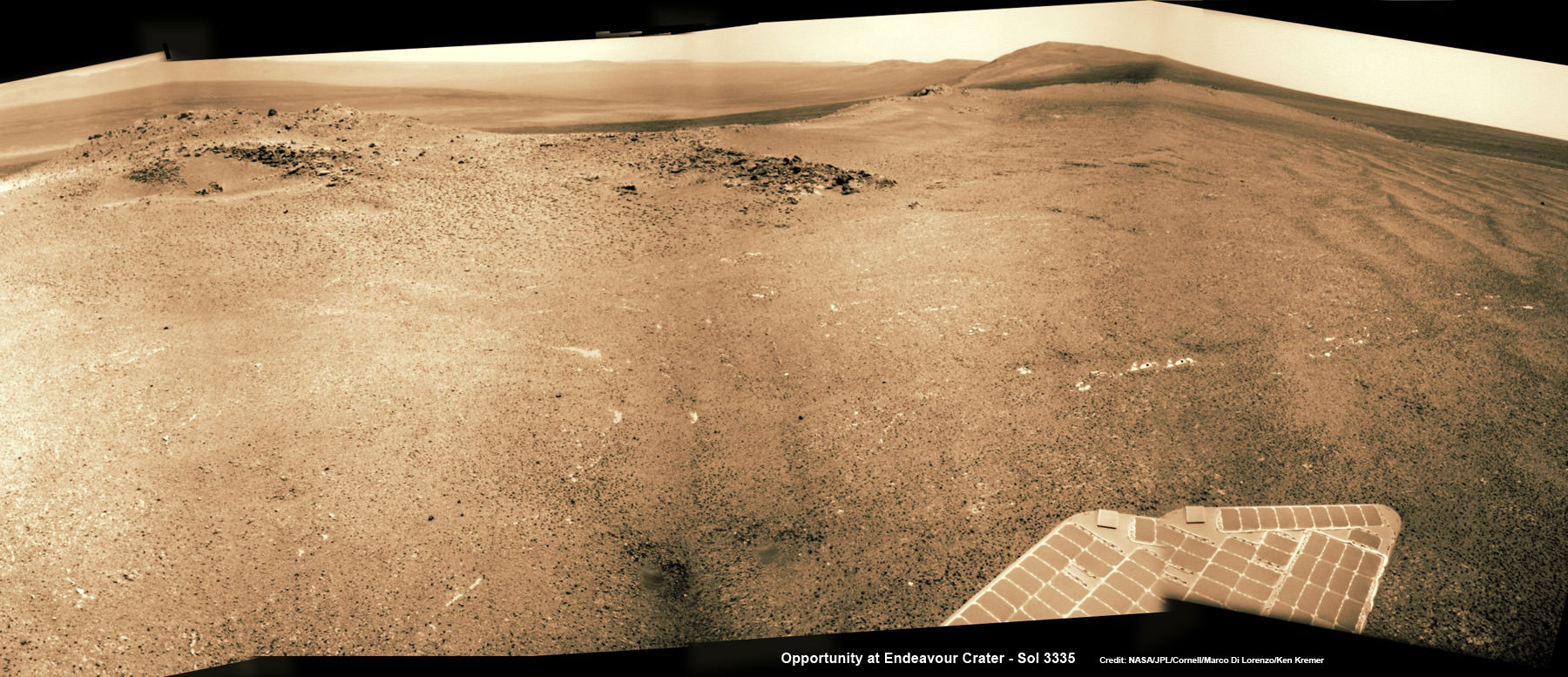
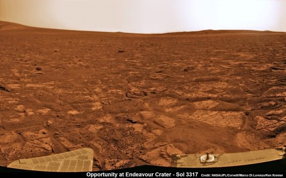
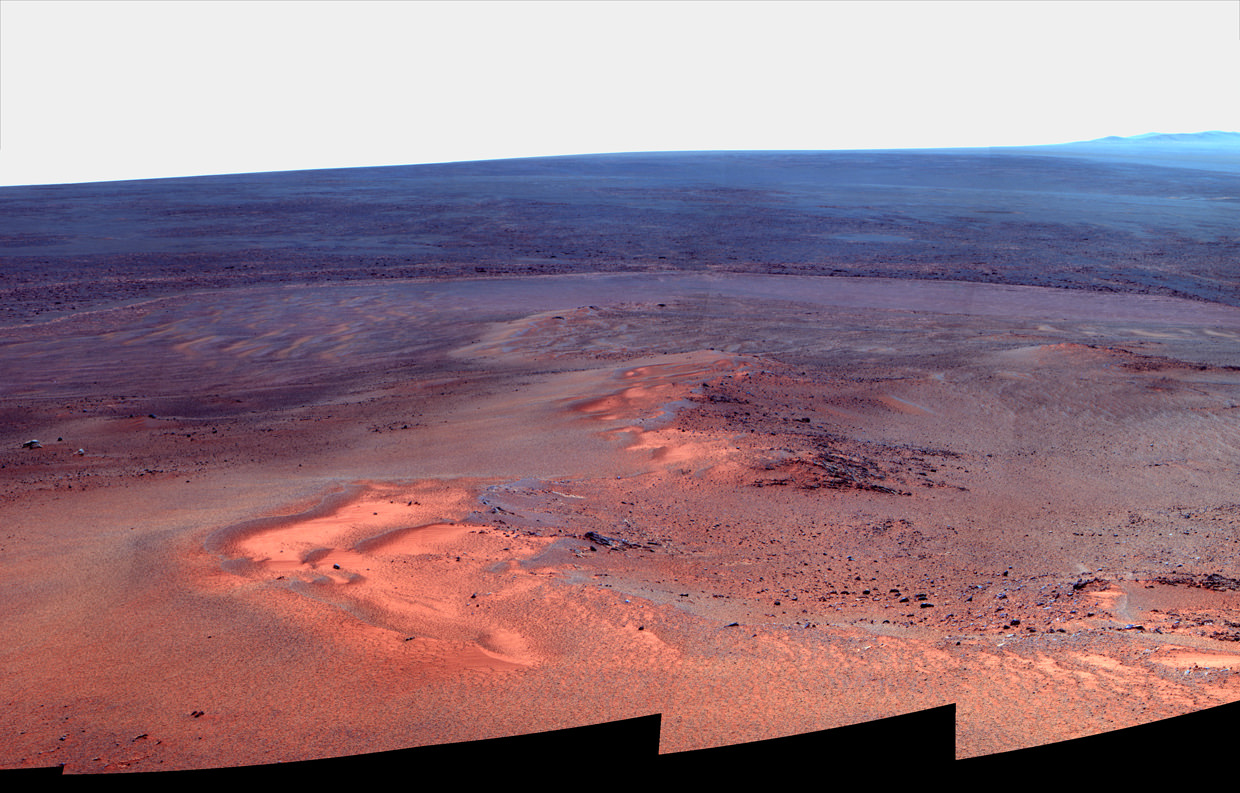
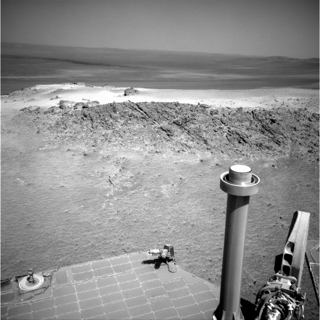
This view from July 2, 2013 (Sol 3355) shows the terrain that NASA’s Mars Exploration Rover Opportunity is crossing in a flat area called “Botany Bay” on the way toward “Solander Point,” which is visible on the horizon. Credit: NASA/JPL-Caltech
“We are making very good progress crossing ‘Botany Bay,’ said John Callas of NASA’s Jet Propulsion Laboratory, Pasadena, Calif., who is project manager for the mission now entering its 2nd decade.
The flat terrain of fractured, light-toned bedrock is devoid of treacherous dunes and is easy to drive across, almost like a highway, which simplifies the daily planning by the rovers Earthly handlers.
“The surface that Opportunity is driving across in Botany Bay is polygonally fractured outcrop that is remarkably good for driving,” said Brad Joliff, an Opportunity science team member and long-term planner at Washington University in St. Louis. “The plates of outcrop, like a tiled mosaic pavement, have a thin covering of soil, not enough to form the wind-blown ripples we’ve had to deal with during some other long treks. The outcrop plates are light-toned, and the cracks between them are filled with dark, basaltic soil and our old friends the ‘blueberries.”
The “blueberries” are hematite-rich, erosion-resistant concretions about the size of BB’s that Opportunity discovered when she first opened her eyes at her Eagle crater landing site. During the multi year crater hopping tour that ensued, the rover continued finding patches of blueberries all the way to Endeavour crater.
1st color panorama taken by Opportunity after landing inside Eagle Crater on Jan. 24, 2004. Credit: NASA/JPL/Cornell
Opportunity is expected to arrive at Solander’s foothills sometime in August – before the onset of the next southern hemisphere Martian winter, her 6th altogether.
Opportunity will scale Solander to continue the science quest in search of additional evidence of habitable environments with the chemical ingredients necessary to sustain Martian microbial life.
“Right now the rover team is discussing the best way to approach and drive up Solander,” Ray Arvidson told Universe Today. Arvidson is the mission’s deputy principal scientific investigator from Washington University in St. Louis, Mo.
‘Solander Point’ offers roughly about a 10 times taller stack of geological layering compared to ‘Cape York.’
Solander also offers north facing slopes where Opportunity’s solar wings can more effectively soak up the sun’s rays to generate life giving electrical power.
The robot remains in excellent health.
The total driving distance exceeds 23 miles (37 kilometers). She has snapped over 181,000 images.
Meanwhile on the opposite side of Mars at Gale Crater, Opportunity’s younger sister rover Curiosity also discovered a habitable environment originating from a time when the Red Planet was far warmer and wetter billions of years ago.
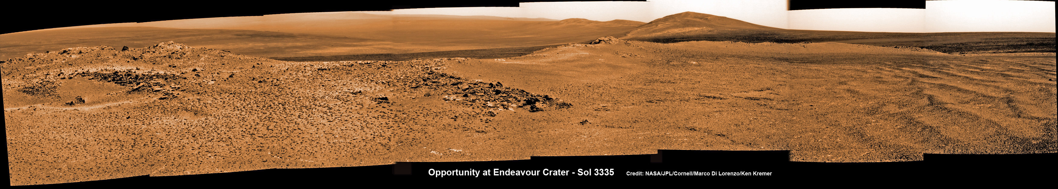
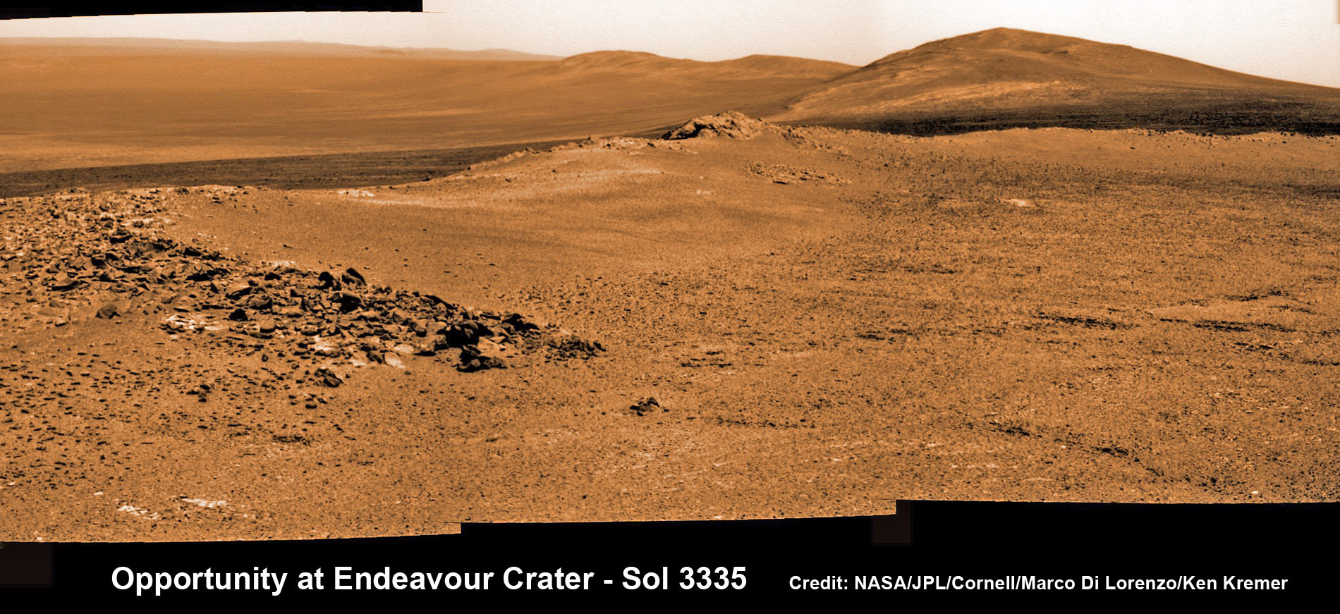
Opportunity captures spectacular panoramic view ahead to her upcoming mountain climbing goal, the raised rim of “Solander Point” at right, located along the western edge of Endeavour Crater. It may harbor clay minerals indicative of a habitable zone. The rise at left is “Nobbys Head” which the rover just passed on its southward drive to Solander Point from Cape York. This pancam photo mosaic was taken on Sol 3335, June 11, 2013 shows vast expanse of the central crater mound and distant Endeavour crater rim. Credit: NASA/JPL/Cornell/ASU/Marco Di Lorenzo/Ken Kremer (kenkremer.com) Traverse Map for NASA’s Opportunity rover from 2004 to 2013
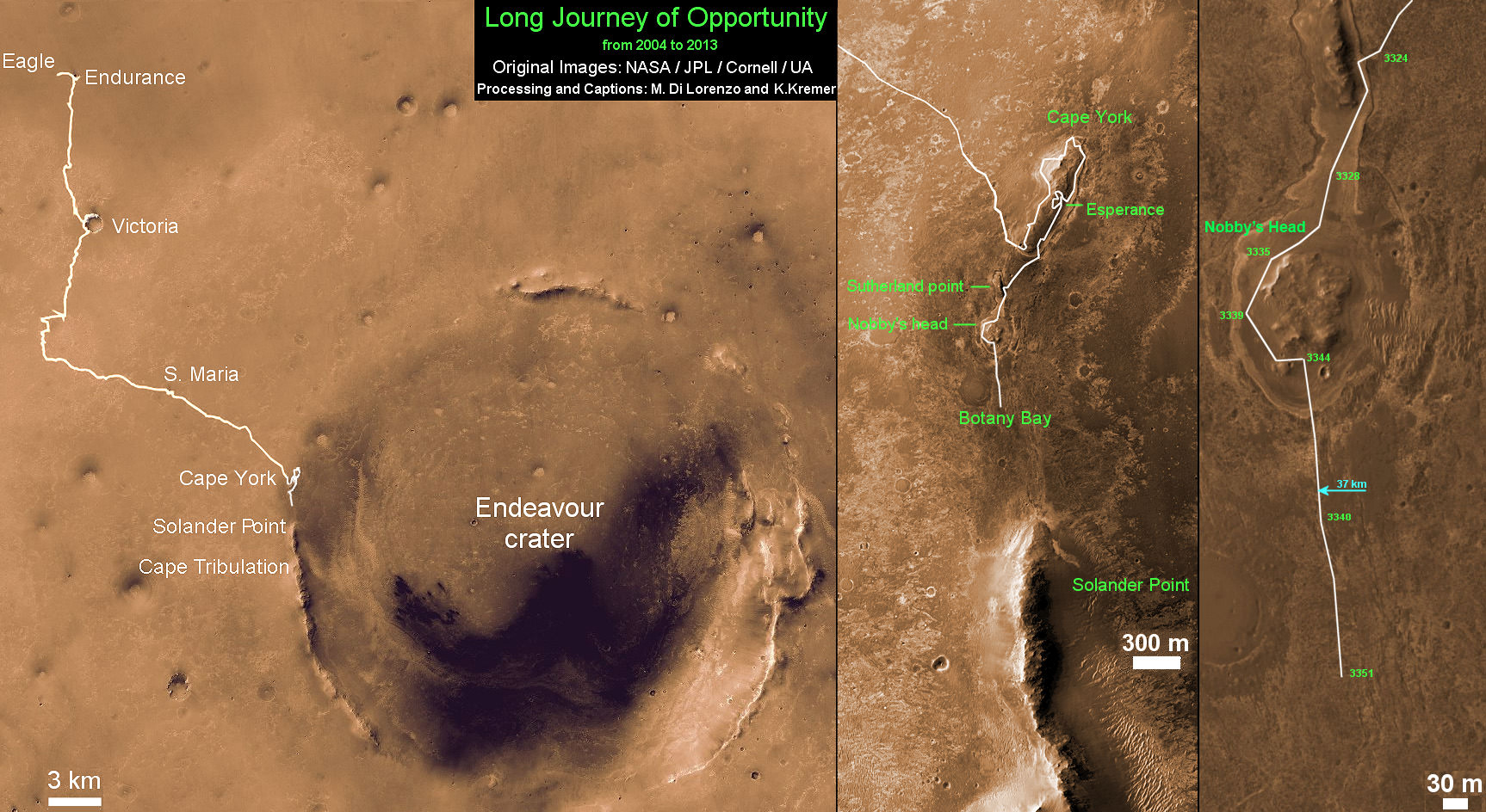
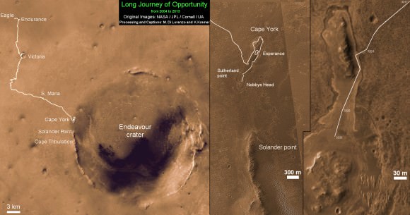
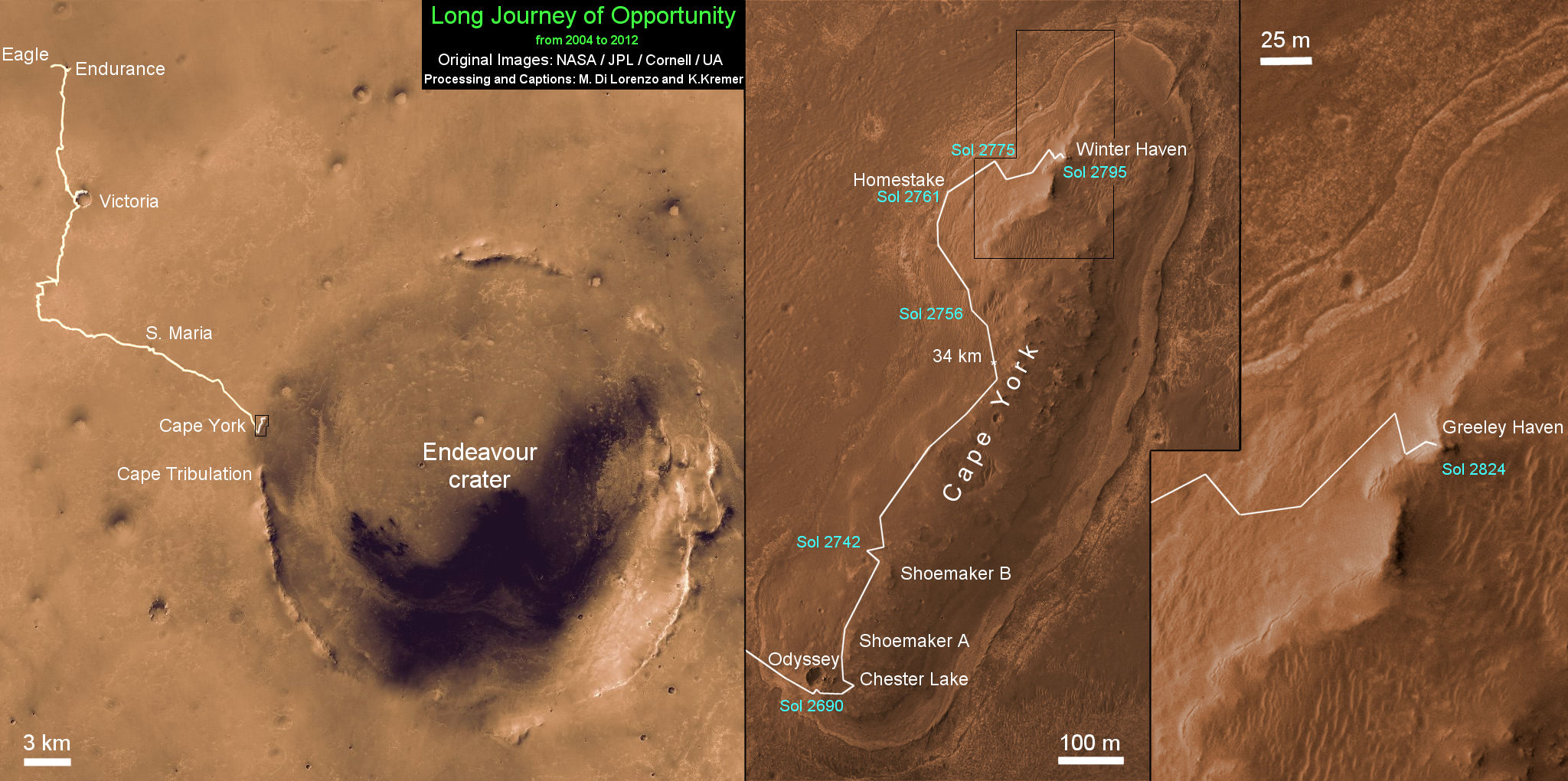
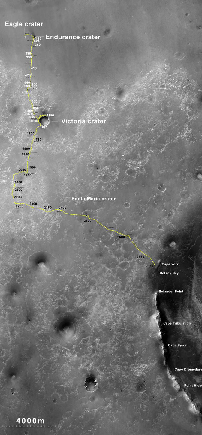
This map shows the entire path the rover has driven during more than 9 years and over 3360 Sols, or Martian days, since landing inside Eagle Crater on Jan 24, 2004 to current location heading south to Solander Point from Cape York ridge at the western rim of Endeavour Crater. Credit: NASA/JPL/Cornell/ASU/Marco Di Lorenzo/Ken Kremer
Opportunity rover captures spectacular view ahead to her upcoming mountain climbing goal, the raised rim of “Solander Point” at right, located along the western edge of Endeavour Crater. It may harbor clay minerals indicative of a habitable zone. This pancam photo mosaic was taken on Sol 3335, June 11, 2013. Credit: NASA/JPL/Cornell/ASU/Marco Di Lorenzo/Ken Kremer (kenkremer.com) See full panoramic scene below
Opportunity rover captures spectacular view ahead to her upcoming mountain climbing goal, the raised rim of “Solander Point” at right, located along the western edge of Endeavour Crater. It may harbor clay minerals indicative of a habitable zone. This pancam photo mosaic was taken on Sol 3335, June 11, 2013. Credit: NASA/JPL/Cornell/ASU/Marco Di Lorenzo/Ken Kremer (kenkremer.com)
See full panoramic scene – below Your last chance to “Send Your Name to Mars aboard NASA’s MAVEN orbiter” – below[/caption]
NASA’s nearly decade old Opportunity Mars rover is sailing swiftly on a southerly course towards her first true mountain climbing destination – named “Solander Point” – in search of further evidence of habitable environments with the chemical ingredients necessary to sustain Martian life forms.
At Solander Point, researchers have already spotted deep stacks of ancient rocks transformed by flowing liquid water eons ago. It is located along the western rim of huge Endeavour Crater.
“Right now the rover team is discussing the best way to approach and drive up Solander,” Ray Arvidson told Universe Today. Arvidson is the mission’s deputy principal scientific investigator from Washington University in St. Louis, Mo.
Solander Point may harbor clay minerals in the rock stacks indicative of a past Martian habitable zone.
“One idea is to drive part way up Solander from the west side of the rim, turn left and then drive down the steeper north facing slopes with the stratographic sections,” Arvidson told me.
“That way we don’t have to drive up the relatively steeper slopes. The rover can drive up rocky surfaces inclined about 12 to 15 degrees.”
“We want to go through the stratographic sections on the north facing sections.”
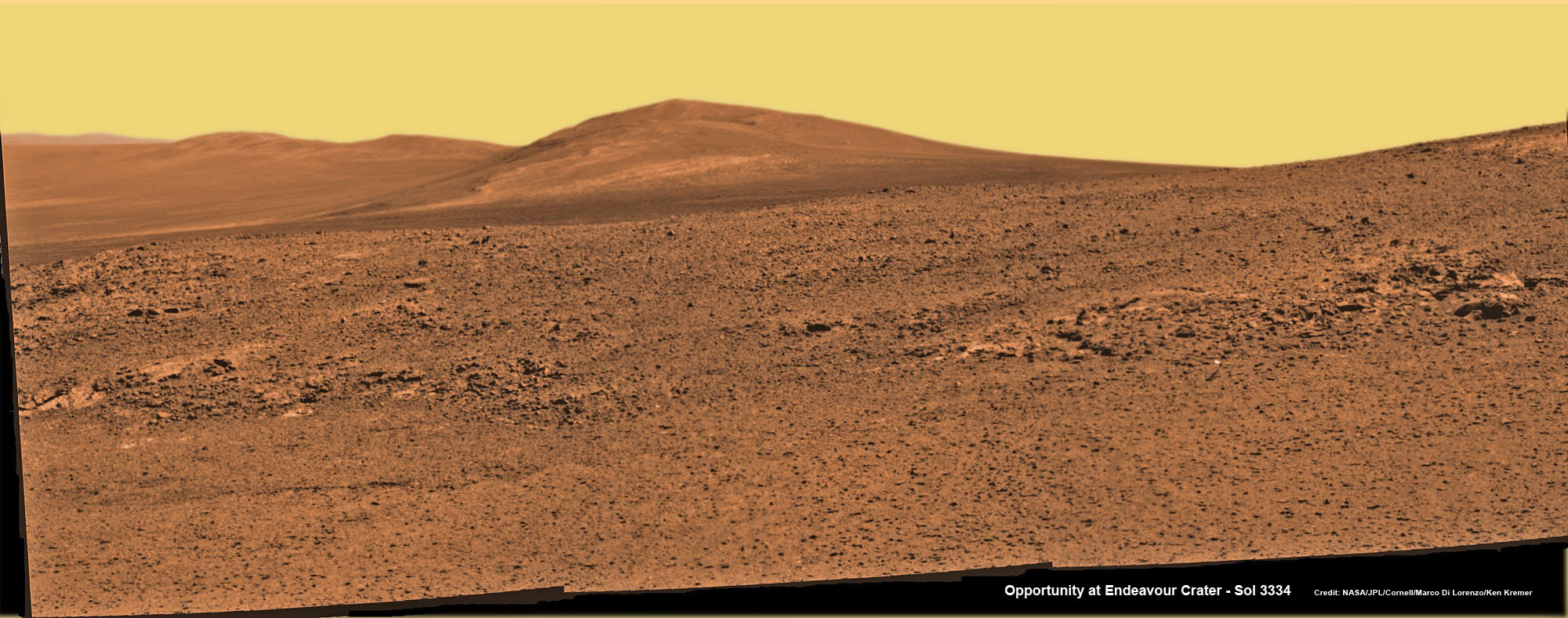
Solander Point mosaic captured by high resolution pancam camera on Sol 3334, June 10, 2013. Opportunity will scale Solander after arriving in August 2013 in search of chemical ingredients to sustain Martian microbes Credit: NASA/JPL/Cornell/ASU/Marco Di Lorenzo/Ken Kremer (kenkremer.com)
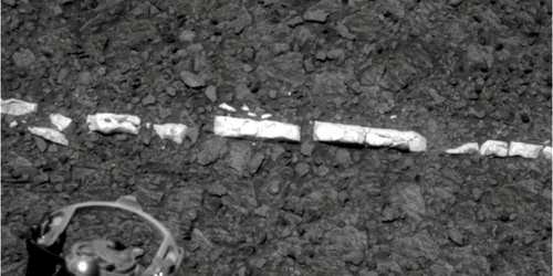
The science team hopes that by scaling Solander, Opportunity will build on her recent historic discovery of a habitable environment at a rock called “Esperance” that possesses a cache of phyllosilicate clay minerals.
These aluminum rich clay minerals typically form in neutral, drinkable water that is not extremely acidic or basic and therefore could support a path to potential Martian microbes.
“Esperance ranks as one of my personal Top 5 discoveries of the mission,” said Steve Squyres of Cornell University, Ithaca, N.Y., principal investigator for NASA’s rover mission at a recent media briefing.
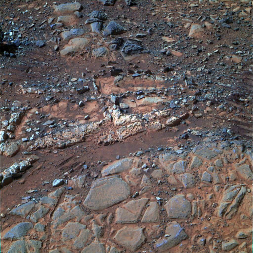
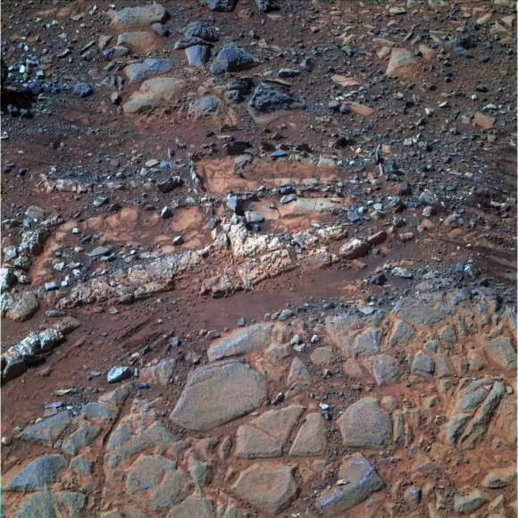
‘Esperance’ Target Examined by Opportunity in May 2013. The pale rock called “Esperance,” has a high concentration of clay minerals formed in near neutral water indcating a spot favorable for life. Credit: NASA/JPL-Caltech/Cornell Univ./Arizona State Univ.
Using high resolution CRISM spectral data collected from Mars orbit, the rover was specifically directed to Esperance, Arvidson explained. The rock was found about a kilometer back on Matijevic Hill at ‘Cape York’, a rather low hilly segment of the western rim of giant Endeavour crater which spans 14 miles (22 km) across.
‘Solander Point’ offers roughly about a 10 times taller stack of geological layering compared to ‘Cape York.’ Both areas are raised segments of the western rim of Endeavour Crater.
The team is working now to obtain the same type of high resolution spectral evidence for phyllosilicate clay minerals at Solander as they had at Cape York to aid in targeting Opportunity to the most promising outcrops, Arvidson explained.
Opportunity is snapping ever more spectacular imagery of Solander Point and the eroded rim of Endeavour Crater as she approaches closer every passing Sol, or Martian Day. See our original photo mosaics herein by Marco Di Lorenzo and Ken Kremer.
Opportunity captures spectacular panoramic view ahead to her upcoming mountain climbing goal, the raised rim of “Solander Point” at right, located along the western edge of Endeavour Crater. It may harbor clay minerals indicative of a habitable zone. The rise at left is “Nobbys Head” which the rover just passed on its southward drive to Solander Point from Cape York. This pancam photo mosaic was taken on Sol 3335, June 11, 2013 shows vast expanse of the central crater mound and distant Endeavour crater rim.
Credit: NASA/JPL/Cornell/ASU/Marco Di Lorenzo/Ken Kremer (kenkremer.com)
The long lived robot arrived at the edge of Endeavour crater in mid-2011 and will spend her remaining life driving around the scientifically rich crater rim segments.
On June 21, 2013, Opportunity marked five Martian years on Mars since landing on Jan 24, 2004 with a mere 90 day (Sol) ‘warranty’.
This week Opportunity’s total driving distance exceeded 23 miles (37 kilometers).
The solar powered robot remains in excellent health and the life giving solar arrays are producing plenty of electrical power at the moment.
Solander Point also offers northerly tilled slopes that will maximize the power generation during Opportunity’s upcoming 6th Martian winter .
The rover handlers want Opportunity to reach Solander’s slopes by August, before winter’s onset.
As ot today (tosol) Opportunity has trekked about halfway from Cape York to Solander Point – tip to tip.
On the opposite side of Mars at Gale Crater, Opportunity’s younger sister rover Curiosity also discovered clay minerals and a habitable environment originating from a time when the Red Planet was far warmer and wetter billions of years ago.
And this is your last chance to “Send Your Name to Mars” aboard NASA’s MAVEN orbiter- details here. Deadline: July 1, 2013. Launch: Nov. 18, 2013
Wide angle view of Endeavour Crater showing Solander Point and Cape Tribulation in this photo mosaic captured by navcam camera on Sol 3335, June 11, 2013. Opportunity will scale Solander after arriving in August 2013 in search of chemical ingredients to sustain Martian microbes. Credit: NASA/JPL/Cornell/Marco Di Lorenzo/Ken Kremer (kenkremer.com)Traverse Map for NASA’s Opportunity rover from 2004 to 2013. This map shows the entire path the rover has driven during more than 9 years and over 3351 Sols, or Martian days, since landing inside Eagle Crater on Jan 24, 2004 to current location heading south to Solander Point from Cape York ridge at the western rim of Endeavour Crater. Credit: NASA/JPL/Cornell/ASU/Marco Di Lorenzo/Ken Kremer
Opportunity captures a panoramic view of the road ahead to the raised rim of Solander Point (at left) which is some 0.8 mile (1.3 km) away. Arrival is targeted for August. It features a thick strata of ancient rocks which may harbor clay minerals indicative of a habitable zone and northerly tilted slopes to maximize power generation from the solar panels during upcoming 6th winter season at Endeavour crater rim. This navcam photo mosaic was taken on Sol 3330, June 6, 2013. Credit: NASA/JPL/Cornell//Marco Di Lorenzo/Ken Kremer (kenkremer.com)
On the cusp of the 10th anniversary since launching to the Red Planet, NASA’s long lived Opportunity rover has discovered a habitable zone on Mars that once coursed with ‘drinkable water’ and possesses the chemical ingredients necessary to support a path to potential Martian microbes.
At a rock called “Esperance”, Opportunity found a cache of phyllosilicate clay minerals that typically form in neutral, drinkable water that is not extremely acidic or basic.
The finding ranks as “One of my personal Top 5 discoveries of the mission,” said Steve Squyres of Cornell University, Ithaca, N.Y., principal investigator for NASA’s rover mission at a media briefing.
And despite her advancing age Opportunity remains healthy after surviving in excess of an incredible 3333 Sols, or days, trekking across the alien and ever harsh Martian crater plains.
Furthermore the intrepid robot just sat sail on a southerly course for a new destination called “Solander Point” where researches hope to find more even evidence of habitable environments since they already spotted deeper stakes of ancient rocks transformed by water eons ago. See our current photo mosaics showing Solander Point as Opportunity roves across the crater floor – above and below by Marco Di Lorenzo and Ken Kremer.
After weeks of trying, the rover deployed the robotic arm to drill at a sweet spot inside “Esperance” and collected convincing X-Ray spectroscopic data in the area she just investigated in May 2013 around the eroded rim of giant Endeavour Crater.
“Esperance is rich in clay minerals and shows powerful evidence of water alteration,” Squyres elaborated.
“This is the most powerful evidence we found for neutral pH water.”
“Clay minerals only tend to form at a more neutral pH. This is water you could drink,” Squyres gushed.
These finding represent the most favorable conditions for biology that Opportunity has yet seen in the rock histories it has encountered after nearly a decade roving the Red Planet.
“This is water that was much more favorable for things like pre-biotic chemistry – the kind of chemistry that could lead to the origin of life,” Squyres stated.
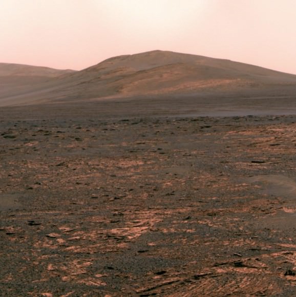
Opportunity snapped this color view of ‘Solander Point’ on June 1, 2013 (Sol 3325) looking south to her next destination which she should reach in August. The solar powered robot will spend the upcoming 6th winter season on northerly tilted slopes exploring the thick strata of ancient rocks. Credit: NASA/JPL-Caltech/Cornell Univ./Arizona State Univ.
Esperance is unlike any rock previously investigated by Opportunity; rich in aluminum, which is strongly indicative of clay minerals, perhaps like montmorillonite.
Most rocks inspected to date by Opportunity were formed in an environment of highly acidic water that is extremely harsh to most life forms.
“If you look at all of the water-related discoveries that have been made by Opportunity, the vast majority of them point to water that was a very low pH – it was acid,” Squyres explained.
Esperance was found on ‘Cape York’, a hilly segment of the western rim of Endeavour crater which spans 14 miles (22 km) across. The robot arrived at the edge of Endeavour crater in mid-2011 and will spend her remaining life driving around the scientifically rich crater rim segments.
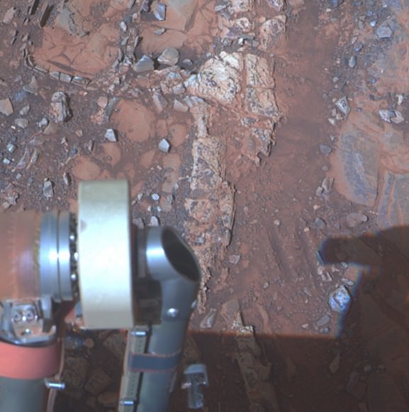
The pale rock in the upper center of this image, about the size of a human forearm, includes a target called “Esperance,” which was inspected by NASA’s Mars Exploration Rover Opportunity. Data from the rover’s alpha particle X-ray spectrometer (APXS) indicate that Esperance’s composition is higher in aluminum and silica, and lower in calcium and iron, than other rocks Opportunity has examined in more than nine years on Mars. Preliminary interpretation points to clay mineral content due to intensive alteration by water. Credit: NASA/JPL-Caltech/Cornell/Arizona State Univ
NASA’s new Curiosity rover also recently discovered clay minerals and a habitable environment at Gale Crater – on the other side of Mars – stemming from a time when Mars was warmer and wetter billions of years ago.
Over time Mars became the cold and dry place it is today. Scientists hope the rovers provide clues to Mars dramatic transformation.
The solar powered rover is now driving as quick as possible to reach the northerly tilled slopes of ‘Solander Point’ in August, before the onset of the next Martian winter.
‘Solander Point’ offers a much taller stack of geological layering than ‘Cape York.’ Both areas are raised segments of the western rim of Endeavour Crater.
“There’s a lot to explore there. In effect, it’s a whole new mission,” said Ray Arvidson, the mission’s deputy principal scientific investigator from Washington University in St. Louis, Mo.
‘Esperance’ Target Examined by Opportunity in May 2013. The pale rock called “Esperance,” has a high concentration of clay minerals formed in near neutral water indcating a spot favorable for life. Credit: NASA/JPL-Caltech/Cornell Univ./Arizona State Univ.
Opportunity and her twin “Spirit” were launched to Mars on planned 90 day missions.
Both rovers have far exceeded everyone’s wildest expectations. Spirit endured more than 6 years inside Gusev Crater until succumbing to the bone chilling Martian winter in 2011.
NASA’s Opportunity Mars rover discovered clay minerals at Cape York ridge along the rim of Endeavour crater – seen in this photo mosaic – which stands as the most favorable location for Martian biology discovered during her entire nearly 10 year long mission to Mars. Opportunity also established a new American driving record for a vehicle on another world on May 15, 2013 (Sol 3309) and made history by driving ahead from this point at Cape York. This navcam photo mosaic shows the view forward to her next destinations of Solander Point and Cape Tribulation along the lengthy rim of huge Endeavour crater spanning 14 miles (22 km) in diameter.
Credit: NASA/JPL/Cornell/Ken Kremer (kenkremer.com)/Marco Di Lorenzo
Opportunity has lasted more than 37 times beyond the three month “warranty”.
“This is like your car not lasting 200,000 miles, or even a million miles. You’re talking about a car that lasts 2 million miles without an oil change,” Callas said. “At this point, how long Opportunity lasts is anyone’s guess.”
“Remember, the rover continues to operate in a very hostile environment, where we have extreme temperature changes every day, and the rover could have a catastrophic failure at anytime,” said John Callas, of NASA’s Jet Propulsion Laboratory, Pasadena, Calif., project manager for the Mars Exploration Rover Project.
“So every day is a gift.”
And don’t forget to “Send Your Name to Mars” aboard NASA’s MAVEN orbiter- details here. Deadline: July 1, 2013
June 23: “Send your Name to Mars on MAVEN” and “CIBER Astro Sat, LADEE Lunar & Antares Rocket Launches from Virginia”; Rodeway Inn, Chincoteague, VA, 8 PM
Opportunity captures the eerie Martian scenery looking south across Botany Bay from the southern tip of Cape York to her next destination – Solander Point, about 1 mile (1.6 km) away. This navcam photo mosaic was taken on Sol 3317, May 23, 2013. Credit: NASA/JPL/Cornell//Marco Di Lorenzo/Ken Kremer (kenkremer.com)Traverse Map for NASA’s Opportunity rover from 2004 to 2013.
This map shows the entire path the rover has driven during more than 9 years and over 3330 Sols, or Martian days, since landing inside Eagle Crater on Jan 24, 2004 to current location heading south to Solander Point from Cape York ridge at the western rim of Endeavour Crater.
Credit: NASA/JPL/Cornell/ASU/Marco Di Lorenzo/Ken Kremer
Martian Vista from Opportunity at Endeavour Crater - 8 Years on Mars. NASA’s Opportunity rover celebrated 8 Years on Mars on January 24, 2012. This mosaic shows portions of the segmented rim of Endeavour crater (14 miles, 22 km wide) after the robot arriving at the craters foothills in August 2011. Large ejecta blocks from a smaller nearby crater are visible in the middle. At Endeavour, Opportunity will investigate the oldest minerals deposits she has ever visited from billions of years ago and which may hold clues to environments that were potentially habitable for microbial life. The rover will eventually drive to Cape Tribulation at right after surviving her 5th winter on Mars. Mosaic Credit: NASA/JPL/Cornell/Marco Di Lorenzo/Kenneth Kremer
[/caption]
Today, the resilient Opportunity robot begins her 9th year roving around beautifully Earth-like Martian terrain where potentially life sustaining liquid water once flowed billions of years ago.
Opportunity celebrates her 8th anniversary on the Red Planet gazing at the foothills of the vast crater named Endeavour, promising a “mother lode” of “watery” science – an unimaginable circumstance since the nail biting landing on the hematite rich plains of Meridiani Planum on 24 January 2004.
“Opportunity is 97 months into the 3 month mission,” team members are proud and universally surprised to say.
“Milestones like 8 years on Mars always make me look forward rather than looking back,” Rover Principal Investigator Prof. Steve Squyres of Cornell University told Universe Today for this article commemorating Opportunity’s landing.
“We’ve still got a lot of exploring to do, but we’re doing it with a vehicle that was designed for a 90-sol mission. That means that every sol is a gift at this point.”
Opportunity has driven more than 21 miles (34 kilometers) across the Red Planet’s surface during what is truly humankind’s first overland expedition on another Planet. See our route map below.
Opportunity Rover Traverse Map at Meridiani Planum on Mars - 2004 to 2012
Traverse map shows the 8 Year Journey of Opportunity from Eagle Crater landing site on Sol 1- Jan. 24, 2004 - to 5th Winter Haven worksite at Greeley Haven at Endeavour Crater rim in January 2012. Opportunity embarked on a crater tour and discovered bountiful evidence for the flow of liquid water on Mars billions of years ago. The robot has shown that ancient ephemeral shallow lakes existed on Mars when the cratered terrain was cut by fluvial channels. Endeavour Crater is 14 miles (22 kilometers) in diameter. Opportunity has so far driven more than 21 miles (34 km) over 8 Years but was only expected to live for 90 Martian days. Credit: NASA/JPL/Cornell/UA/Marco Di Lorenzo/Kenneth Kremer
NASA’s twin rovers Spirit and Opportunity blasted off for Mars atop a pair of Delta II rockets in the summer of 2003 with a mission “warranty” of just 90 Martian days, or Sols.
Today is Sol 2846 of working operations for Opportunity, compared to an anticipated lifetime of only 90 Sols – that amounts to more than 31 times beyond the designer’s expectations.
Indeed, the long lived robot is now enduring her 5th Winter on Mars. And to glimpse the next Martian sunrise, the robo girls manmade components must survive the harsh extremes of frigid Antarctic-like temperatures each and every sol.
“I never thought that we would still be planning sequences for Opportunity today,” Ray Arvidson told Universe Today. Arvidson, of Washington University in St. Louis, is the deputy rover principal investigator.
“I seriously thought both Spirit and Opportunity would be finished by the summer of 2004.”
Opportunity's Eighth Anniversary View From 'Greeley Haven' (False Color). This mosaic of images taken in mid-January 2012 shows the windswept vista northward (left) to northeastward (right) from the location where Opportunity is spending its fifth Martian winter, an outcrop informally named "Greeley Haven. Credit: NASA/JPL-Caltech/Cornell/Arizona State Univ.
But, Opportunity is the gift to science that keeps on giving.
“I am feeling pretty good as the MER rover anniversaries approach,” Arvidson told me.
“Opportunity has shown that ancient ephemeral shallow lakes existed as Mars moved climatically from an early period when the cratered terrain was cut by fluvial channels to the current dry and cold conditions that dominate.”
“Both rovers have conclusively shown the need for lateral mobility to get to relevant outcrops and back out the secrets associated with past conditions,” Arvidson explained.
Barely a month ago the bountiful harvest from mobility was once again demonstrated when the science team lead by Squyres and Arvidson announced that Opportunity had discovered the most scientifically compelling evidence yet for the flow of liquid water on ancient Mars.
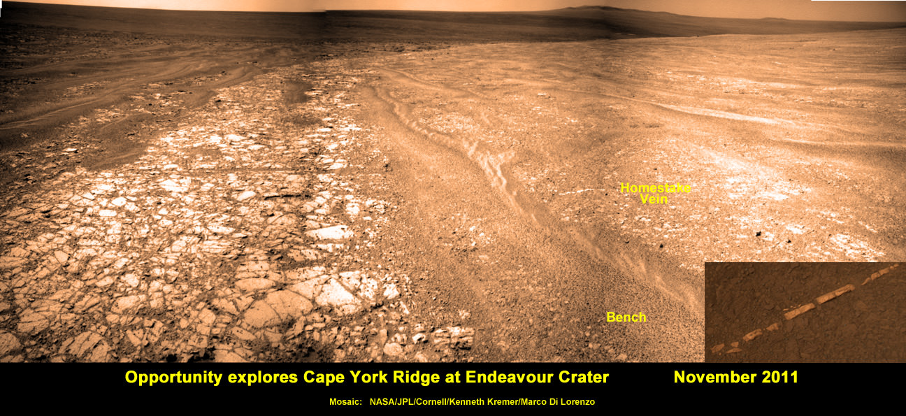
Squyres and Arvidson announced that Opportunity had found a bright vein – named “Homestake” – composed of the mineral gypsum located at the Cape York segment of Endeavour Crater where the intrepid robot is currently spending her 5th Martian Winter.
“This gypsum vein is the single most powerful piece of evidence for liquid water at Mars that has been discovered by the Opportunity rover,” Squyres explained.
Veins are a geologic indication of the past flow of liquid water.
See our mosaic below illustrating the exact location of the “Homestake” vein at Endeavour Crater – also published at Astronomy Picture of the Day; 12 Dec 2011.
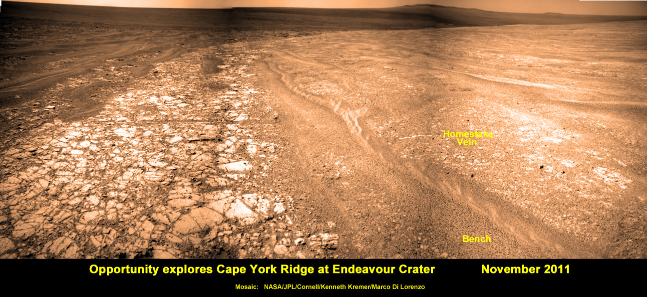
Opportunity discovers Water related Mineral Vein at Endeavour Crater - November 2011
Opportunity rover discovered Gypsum at the Homestake mineral vein, while exploring around the base of Cape York ridge at the rim of Endeavour Crater. The vein is composed of calcium sulfate and indicates the ancient flow of liquid water at this spot on Mars. This panoramic mosaic of images was taken on Sol 2761, November 2011, and illustrates the exact spot of the mineral vein discovery.
Credit: NASA/JPL/Cornell/Kenneth Kremer/Marco Di Lorenzo
Published on Astronomy Picture of the Day (APOD): 12 Dec 2011
Opportunity just arrived at the rim of the 14 mile (22 kilometer) wide Endeavour Crater in mid-August 2011 following an epic three year trek across treacherous dune fields from her prior investigative target at the ½ mile wide Victoria Crater.
“It’s like a whole new mission since we arrived at Cape York,” says Squyres.
For the next few months of the bitterly cold Martian winter, Opportunity will conduct a vigorous science campaign while remaining mostly stationary at a spot dubbed “Greeley Haven” in honor of Prof. Ronald Greeley, a team member from Arizona State University who recently passed away.
Opportunity Mars Rover at 5th Winter Worksite at Endeavour Crater
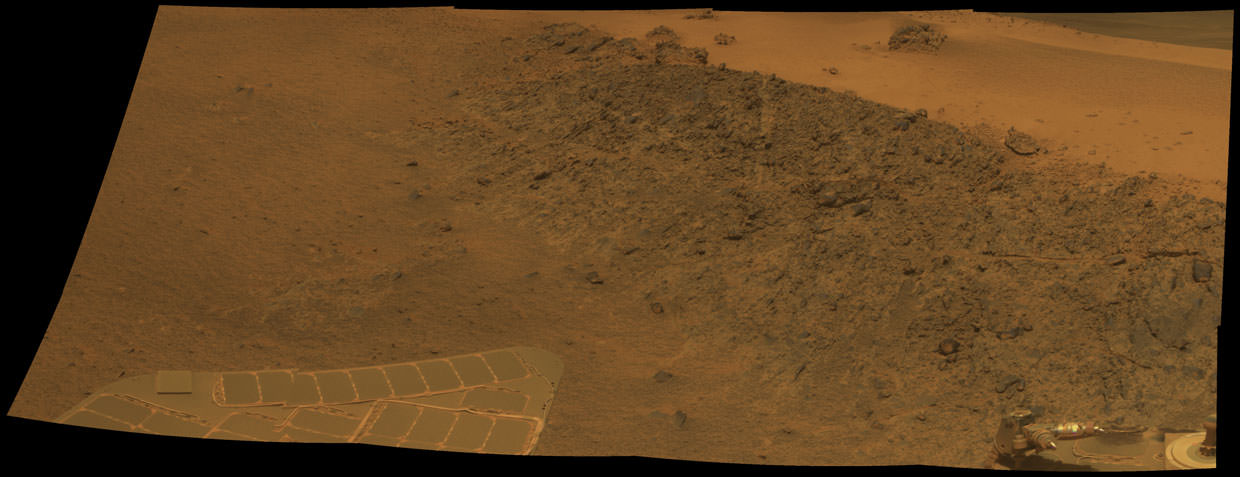
This mosaic shows the view of NASA’s Opportunity rover parked at “Greeley Haven” worksite where the robot will spend her 5th Martian Winter. This mosaic of images shows the Winter Haven view from the Cape York Ridge at the western rim of Endeavour Crater looking south along the crater rim. Tire tracks at right. Credit: NASA/JPL/Cornell/ Marco Di Lorenzo/Kenneth Kremer
At this moment Opportunity is snapping a 360 degree panorama, deploying her robotic arm onto nearby outcrops, collecting microscopic images, making measurements of mineral compositions with the Alpha Particle X-Ray Spectrometer and conducting radio science observations to elucidate the unknown structure of the Martian interior and core.
The rover is covered with a significant coating of dust which limits her ability to generate power from the life sustaining solar arrays. Since Opportunity is traversing just south of the equator, engineers have temporarily parked her on a northerly facing slope to maximize the electric power generation.
“Opportunity is currently sitting on an outcrop of impact breccias at Greeley Haven on Cape York,” said Arvidson.
Opportunity will remain at Greeley Haven until some time after the Winter Solstice of southern Martian winter occurs at the end of March. 'Greeley Haven' Site for Opportunity's Fifth Martian Winter. This mosaic of Greeley Haven was acquired by Opportunity on Sol 2793, Dec. 2, 2011. Credit: NASA/JPL-Caltech/Cornell/Arizona State Univ.
Then she’ll head south to further explore the veins and eventually drive to deposits of the clay mineral located a few miles (km) away along the craters rim.
“We’ll do good science while we’re at Greeley Haven. But as soon as we catch a wind gust or the seasons change, we’ll be on our way again,” Squyres told me.
The legendary twins Spirit and Opportunity surely rank as one of the greatest triumphs in space exploration.
Opportunity Mars Rover at Winter Haven Worksite at Endeavour Crater. NASA’s Opportunity rover has parked near this spot at the “Greeley Haven” worksite where the robot will spend her 5th Martian Winter Haven since landing 8 years ago in January 2004. This mosaic of images was snapped in December 2011 and shows the view from the Cape York Ridge at the western rim of Endeavour Crater looking south along the crater rim to a future area that Opportunity will drive to and explore next spring. Credit: NASA/JPL/Cornell/ Marco Di Lorenzo/Kenneth Kremer
[/caption]
NASA’s seemingly indestructible Opportunity rover has arrived at the breathtaking location where she’ll be working through her unfathomable 5th Martian Winter. The Opportunity Mars Exploration Rover has not only endured, but flourished for 8 years of unending “Exploration & Discovery” on the Red Planet despite having an expected lifetime at landing of just 3 months, way back in January 2004.
Opportunity is parked at a northward facing outcrop dubbed “Greeley Haven” where she can soak up the sun and juice her innards throughout the utterly harsh and Antarctic-like temperatures on tap for the next few months that threaten to kill her each and every Martian day. See our mosaic above around the Greeley Haven area.
Science team members told Universe Today that the rover is sitting at Greeley Haven because the site offers a roughly 15 degree tilt that will maximize the electric output from the life-giving solar arrays and also allow the robot to carry out a vigorous science campaign during the seasonal Martian winter season that officially begins in March.
Greeley Haven is a located at the northern tip of the “Cape York” segment of the western rim of the vast crater named Endeavour, some 14 miles (22 km) wide that’s loaded with a bountiful variety of rocks and soil that neither Opportunity nor her twin Spirit have ever touched and drilled into before and stem from an earlier epoch when liquid water flowed eons ago and perhaps may have been more favorable to sustaining life.
“Opportunity is currently sitting on Saddleback at Greeley Haven, an outcrop of impact breccias on Cape York, Endeavour crater’s rim,” Ray Arvidson told Universe Today. Arvisdon is the mission’s deputy principal investigator, of Washington University in St. Louis.
“Her northerly tilt is about ~15 degrees which is enough to have a vibrant winter campaign. The Martian southern winter solstice occurs at the end of March. A few months after that date we will drive her off the outcrop and further explore Cape York.”
Approaching 'Greeley Haven' on Endeavour Rim
Opportunity captured this view of a northward-facing outcrop, "Greeley Haven," where the rover will work during its fifth Martian winter. This southward-looking image was taken on Sol 2790 on Mars (Nov. 29, 2011). The rover team chose this designation as a tribute to the influential planetary geologist Ronald Greeley (1939-2011), who was a member of the science team for the Mars rovers and many other interplanetary missions. Credit: NASA/JPL-Caltech
“Greeley Haven” is named in tribute to planetary Geologist Ronald Greeley (1939-2011) who was a beloved member of the rover science team and a host of other NASA planetary missions. He taught at Arizona State University and inspired several generations of students and planetary scientists until his recent death on Oct. 27, 2011.
“We’ll hunker down at Greeley Haven as long as we need to, and we’ll do good science while we’re there,” Steve Squyres of Cornell University, Ithaca, N.Y., told Universe Today. Squyres is the Principal Investigator for Opportunity.
Opportunity is collecting a high resolution 360 degree panorama to commemorate Greeley.
Throughout the past 4 Martian winters, Opportunity had continued to traverse without pause. But this winter time it’s different because the solar panels are significantly more coated with an obscuring layer of dust hindering their energy output.
So the rover is parked with a tilt for her 5th Martian winter, mimicking the successful strategy power boosting used by Spirit to survive 3 harsh Martian winters.
And there is a silver lining to sitting mostly still that enables a chance to determine what’s at the core of the Red Planet, a key fact we don’t know.
“This winter science campaign will feature two way radio tracking with Earth to determine the Martian spin axis dynamics – thus the interior structure, a long-neglected aspect of Mars,” Arvidson told me.
I asked Squyres for a progress update and how long would the data collection require ?
Squyres replied that the experiment has already begun and added – “Hard to say how long. It’s months, as opposed to weeks or years, but it depends very much on data quality and the amount of data we get per week. We’re very early in the experiment now… we’ll just see how it goes.”
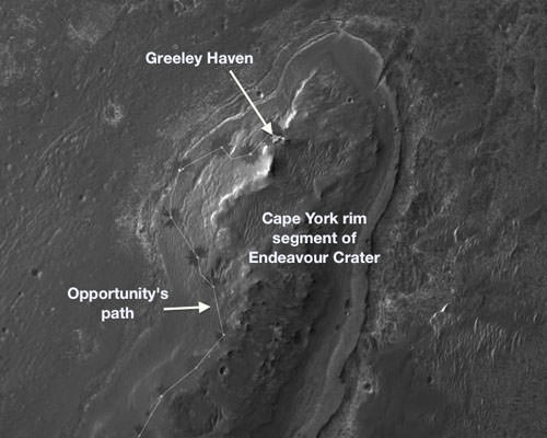
Locator Map for 'Greeley Haven' on Endeavour Crater Rim
Opportunity will spend its fifth Martian winter working at Greeley Haven on the western rim of Endeavour Crater. Credit: NASA/JPL-Caltech/UA
Opportunity discovers Water related mineral vein at Endeavour Crater - November 2011. Opportunity rover discovered Gypsum at the Homestake mineral vein, while exploring around the base of Cape York ridge at the rim of Endeavour Crater. The vein is composed of calcium sulfate and indicates the ancient flow of liquid water at this spot on Mars. Opportunity drove North (ahead) from here in search of a sunny winter haven. Credit: NASA/JPL/Cornell/Kenneth Kremer/Marco Di Lorenzo
[/caption]
NASA’s long lived Opportunity rover has discovered the most scientifically compelling evidence yet for the flow of liquid water on ancient Mars. The startling revelation comes in the form of a bright vein of the mineral gypsum located at the foothills of an enormous crater named Endeavour, where the intrepid robot is currently traversing. See our mosaic above, illustrating the exact spot.
Update: ‘Homestake’ Opportunity Mosaic above has just been published on Astronomy Picture of the Day (APOD) – 12 Dec 2011 (by Ken Kremer and Marco Di Lorenzo)
Researchers trumpeted the significant water finding this week (Dec. 7) at the annual winter meeting of the American Geophysical Union (AGU) in San Francisco.
“This gypsum vein is the single most powerful piece of evidence for liquid water at Mars that has been discovered by the Opportunity rover,” announced Steve Squyres of Cornell University, Ithaca, N.Y., Principal Investigator for Opportunity, at an AGU press conference.
The light-toned vein is apparently composed of the mineral gypsum and was deposited as a result of precipitation from percolating pools of liquid water which flowed on the surface and subsurface of ancient Mars, billions of years ago. Liquid water is an essential prerequisite for life as we know it.
“This tells a slam-dunk story that water flowed through underground fractures in the rock,” said Squyres. “This stuff is a fairly pure chemical deposit that formed in place right where we see it. That can’t be said for other gypsum seen on Mars or for other water-related minerals Opportunity has found. It’s not uncommon on Earth, but on Mars, it’s the kind of thing that makes geologists jump out of their chairs.”
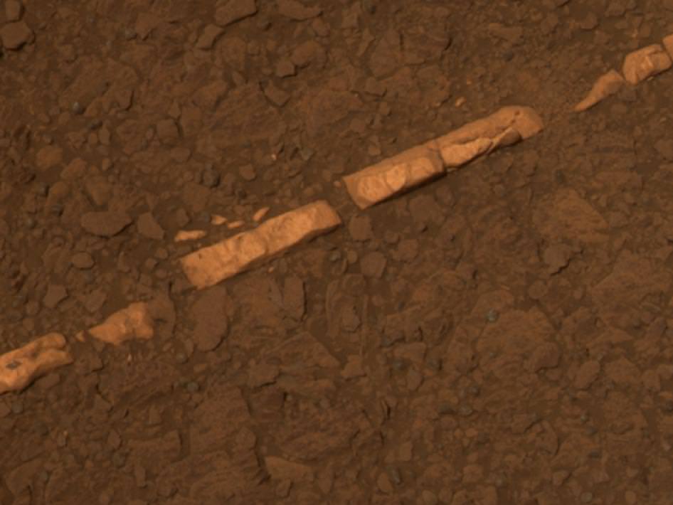
'Homestake' Vein in Color and Close-up
This color view of a mineral vein called "Homestake" was taken by the panoramic camera (Pancam) on NASA's Mars Exploration Rover Opportunity. The vein is about the width of a thumb and about 18 inches (45 centimeters) long. Opportunity examined it in November 2011 and found it to be rich in calcium and sulfur, possibly the calcium-sulfate mineral gypsum.
The light-toned vein is informally named “Homestake”, and was examined up close by Opportunity’s cameras and science instruments for several weeks this past month in November 2011, as the rover was driving northwards along the western edge of a ridge dubbed ‘Cape York’ – which is a low lying segment of the eroded rim of Endeavour Crater.
Veins are a geologic indication of the past flow of liquid water
Opportunity just arrived at the rim of the 14 mile (22 kilometere) wide Endeavour Crater in mid-August 2011 following an epic three year trek across treacherous dune fields from her prior investigative target at the ½ mile wide Victoria Crater.
“It’s like a whole new mission since we arrived at Cape York,” said Squyres.
‘Homestake’ is a very bright linear feature.
“The ‘Homestake’ vein is about 1 centimeter wide and 40 to 50 centimeters long,” Squyres elaborated. “It’s about the width of a human thumb.”
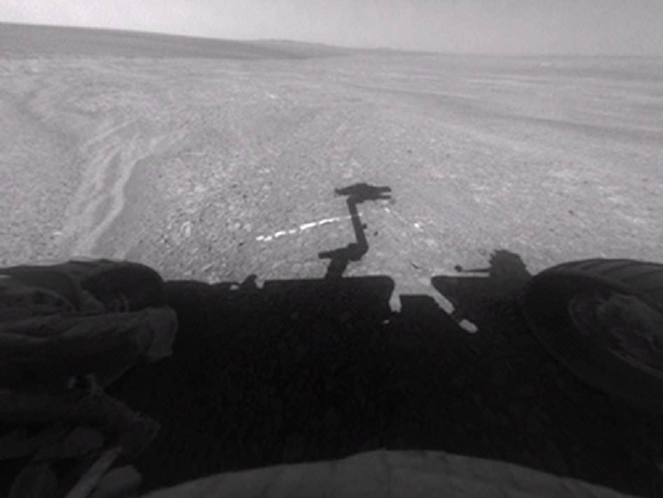
Opportunity's Approach to 'Homestake'
This view from the front hazard-avoidance camera on NASA's Mars Exploration Rover Opportunity shows the rover's arm's shadow falling near a bright mineral vein informally named Homestake. The vein is about the width of a thumb and about 18 inches (45 centimeters) long. Opportunity examined it in November 2011 and found it to be rich in calcium and sulfur, possibly the calcium-sulfate mineral gypsum. Opportunity took this image on Sol 2763 on Mars (Nov. 7, 2011). Credit: NASA/JPL-Caltech
Homestake protrudes slightly above the surrounding ground and bedrock and appears to be part of a system of mineral veins running inside an apron (or Bench) that in turn encircles the entire ridge dubbed Cape York.
In another first, no other veins like these have been seen by Opportunity throughout her entire 20 miles (33 kilometers) and nearly eight year long Martian journey across the cratered, pockmarked plains of Meridiani Planum, said Squyres.
The veins have also not been seen in the higher ground around the rim at Endeavour crater.
“We want to understand why these veins are in the apron but not out on the plains,” said the mission’s deputy principal investigator, Ray Arvidson, of Washington University in St. Louis. “The answer may be that rising groundwater coming from the ancient crust moved through material adjacent to Cape York and deposited gypsum, because this material would be relatively insoluble compared with either magnesium or iron sulfates.”
Opportunity was tasked to engage her Microscopic Imager and Alpha Particle X-ray Spectrometer (APXS) mounted on the terminus of the rover’s arm as well as multiple filters of the mast mounted Panoramic Camera to examine ‘Homestake’.
“The APXS spectrometer shows ’Homestake’ is chock full of Calcium and Sulfur,” Squyres gushed.
Microscopic Close-up View of 'Homestake' Vein
This close-up view of a mineral vein called Homestake comes from the microscopic imager on Opportunity. The vein is about the width of a thumb and about 18 inches (45 centimeters) long. Opportunity examined it in November 2011 and found it to be rich in calcium and sulfur, possibly the calcium-sulfate mineral gypsum. Homestake is near the edge of the "Cape York" segment of the western rim of Endeavour Crater. This view blends three exposures taken by the microscopic imager during the 2,765th and 2,766th Martian days, or sols, of Opportunity's career on Mars (Nov. 3 and 4, 2011). Credit: NASA/JPL-Caltech/Cornell/USGS
The measurements of composition with the APXS show that the ratio points to it being relatively pure calcium sulfate, Squyres explained. “One type of calcium sulfate is gypsum.”
Calcium sulfate can have varying amounts of water bound into the minerals crystal structure.
The rover science team believes that this form of gypsum discovered by Opportunity is the dihydrate; CaSO4•2H2O. On Earth, gypsum is used for making drywall and plaster of Paris.
The gypsum was formed in the exact spot where Opportunity found it – unlike the sulfate minerals previously discovered which were moved around by the wind and other environmental and geologic forces.
“There was a fracture in the rock, water flowed through it, gypsum was precipitated from the water. End of story,” Squyres noted. “There’s no ambiguity about this, and this is what makes it so cool.”
At Homestake we are seeing the evidence of the ground waters that flowed through the ancient Noachian rocks and the precipitation of the gypsum, which is the least soluble of the sulfates, and the other magnesium and iron sulfates which Opportunity has been driving on for the last 8 years.
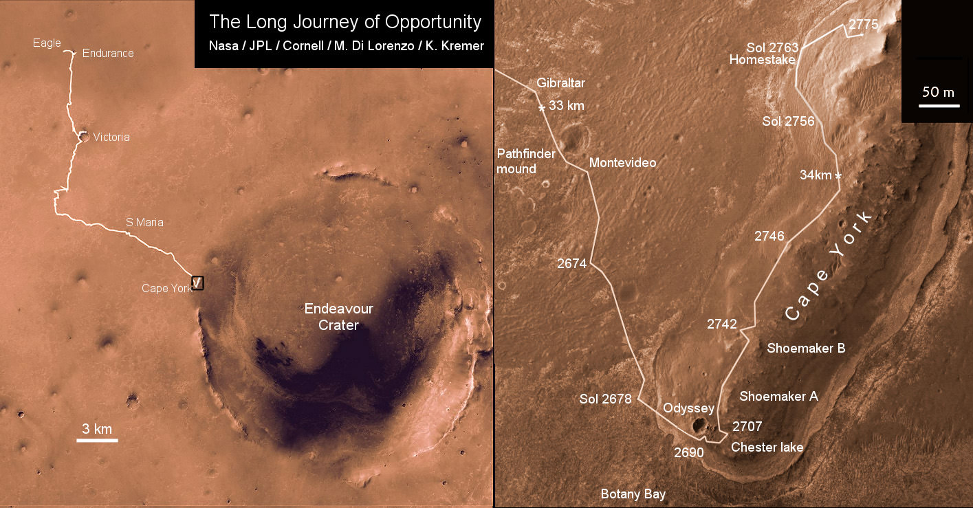
Opportunity Traverse Map 2004 to 2011
Traverse map showing the 8 Year Journey of Opportunity from Eagle Crater landing site Sol 1 (Jan. 24, 2004) to Sol 2775 (November 2011). Map shows rover location around Homestake water related mineral on Sol 2763 (November 2011) at Cape York ridge at Endeavour Crater rim. Endeavour Crater is 14 miles or 22 kilometers in diameter. Opportunity has driven more than 21 miles (34 km).
Credit: NASA/JPL/Cornell/Marco Di Lorenzo/Kenneth Kremer
“Here, both the chemistry, mineralogy, and the morphology just scream water,” Squyres exclaimed. “This is more solid than anything else that we’ve seen in the whole mission.”
It’s inconceivable that the vein is something else beside gypsum, said Squyres.
As Opportunity drove from the plains of Meridiani onto the rim of Endeavour Crater and Cape York, it crossed a geologic boundary and arrived at a much different and older region of ancient Mars.
The evidence for flowing liquid water at Endeavour crater is even more powerful than the silica deposits found by Spirit around the Home Plate volcanic feature at Gusev Crater a few years ago.
“We will look for more of these veins in the [Martian] springtime,” said Squyres.
If a bigger, fatter vein can be found, then Opportunity will be directed to grind into it with her still well functioning Rock Abrasion Tool, or RAT.
Homestake was crunched with the wheels – driving back and forth over the vein – to break it up and expose the interior. Opportunity did a triple crunch over Homestake, said Arvidson.
Homestake was found near the northern tip of Cape York, while Opportunity was scouting out a “Winter Haven” location to spend the approaching Martian winter.
Arvidson emphasized that the team wants Opportunity to be positioned on a northerly tilted slope to catch the maximum amount of the sun’s rays to keep the rover powered up for continuing science activities throughout the fast approaching Martian winter.
“Martian winter in the southern hemisphere starts on March 29, 2012. But, Solar power levels already begin dropping dramatically months before Martian winter starts,” said Alfonso Herrera to Universe Today, Herrera is a Mars rover mission manager at NASA’s Jet Propulsion Laboratory in Pasadena, Calif.
“Opportunity is in excellent health,” said Bruce Banerdt, the Project Scientist for the Mars rover mission at JPL.
“This has been a very exciting time. We’ll head back south in the springtime and have a whole bunch of things to do with a very capable robot,” Squyres concluded.
'Botany Bay' and 'Cape York' with Vertical Exaggeration
This graphic combines a perspective view of the "Botany Bay" and "Cape York" areas of the rim of Endeavour Crater on Mars, and an inset with mapping-spectrometer data. Major features are labeled. In the perspective view, the landscape's vertical dimension is exaggerated five-fold compared with horizontal dimensions. NASA's Mars Exploration Rover Opportunity examined targets in the Cape York area during the second half of 2011. The perspective view was generated by producing an elevation map from a stereo pair of images from the High Resolution Imaging Science Experiment (HiRISE) camera on NASA's Mars Reconnaissance Orbiter, then draping one of the HiRISE images over the elevation model. The inset presents data from the Compact Reconnaissance Imaging Spectrometer for Mars (CRISM) instrument on the Mars Reconnaissance Orbiter. In this CRISM observation, taken on March 29, 2011 Thermal inertia estimates from observations by the Thermal Emission Imaging System on NASA's Mars Odyssey orbiter indicate that Botany Bay is a region with extensive outcrop exposures. Credit: NASA/JPL-Caltech/UA/JHUAPL
Meanwhile, NASA’s next leap in exploring potential Martian habitats for life – the car sized Curiosity Mars Science Lab rover – is speeding towards the Red Planet.
Read Ken’s continuing features about Opportunity starting here:
Opportunity - Panoramic view inside vast Endeavour Crater snapped ascending Cape York crater ridge on Sol 2754, October 23, 2011. Opportunity wheel tracks at right. Cape Tribulation and distant, far side Endeavour crater rim in background. Opportunity is now driving to the northern tip of Cape York in search of a winter haven to survive upcoming brutal Martian Antarctic winter temperatures. Credit: NASA/JPL/Cornell. See the entire panorama in 2 D and 3 D and route maps below.
[/caption]
NASA’s intrepid robogirl Opportunity is now swiftly scouting out locations at a Martian hill along gigantic Endeavour crater that would simultaneously proffer a goldmine of sun and science as her power level drops significantly in these waning days of Martian autumn ahead of the absolutely brutal and potentially deadly 6 month long Antarctic winter that’s fast approaching. Opportunity has just discovered a geologic vein possibly formed as a result of flowing water eons ago.
But, search time for a sunny exposure at the Martian hill known as Cape York is running out says the Mars rover team in new interviews with Universe Today. Recall that lack of power and utterly frigid temperatures killed her twin sister Spirit last winter.
“Martian winter in the southern hemisphere starts on March 29, 2012 or Sol 2908. But, Solar power levels already begin dropping dramatically months before Martian winter starts,” said Alfonso Herrera to Universe Today, Herrera is a Mars rover mission manager at NASA’s Jet Propulsion Laboratory in Pasadena, Calif.
“Orbital imagery indicates that the northern-most tip of Cape York might have north facing slopes which Opportunity will need in order to generate enough solar power to sustain her comfortably throughout the winter,” Herrera explained to me.
The team is very excited about the science implications of the vein detection.
“The importance of veins is that often they occur from the deposition of material that was dissolved and transported by hot water in cracks deep underground,” said Bruce Banerdt to Universe Today. Banerdt is the Project Scientist for the Mars rover mission at JPL.
Traverse map showing the 7 Year Journey of Opportunity from Eagle Crater landing site Sol 1 (Jan. 24, 2004) to current location around Homestake on Sol 2763 (November 2011) at Cape York ridge at Endeavour Crater rim. Endeavour Crater is 14 miles or 22 kilometers in diameter. Opportunity has driven more than 21 miles (34 km). Credit: NASA/JPL/Cornell/Marco Di Lorenzo/Kenneth Kremer
Segments of Endeavour’s rim at Cape York and Cape Tribulation about 6 kilometers further south offers scientifically rich motherlodes of phyllosilicate clay minerals and other water bearing minerals that formed Billions of years ago on Mars and that could possibly point to habitats favorable for the genesis and support of Martian microbial life forms if they ever existed in the past or present.
Opportunity is currently traversing about the hilltops and slopes of Cape York where she recently made landfall after an epic three year trek across the plains of the Meridiani Planum region of Mars.
Initial reconnaissance around the southern tip and then climbing on top of the central ridge of Cape York have already yielded a bonanza of new science data at rock types never seen before on Mars, according to Steve Squyres, the Mars Rover Principal Investigator of Cornell University.
The rover is now driving north and back down around the base while searching for a “winter haven” with more potential for great science and a northerly inclined slope to more efficiently catch the sun’s rays.
“Opportunity is heading north to find the best winter site,” Ray Arvidson told Universe Today. Arvidson is the rover’s deputy principal investigator, of Washington University in St. Louis.
“We are more than halfway toward the northern part of Cape York where there are slopes steep enough to provide an energy-valid winter site and where science can take place. Now we are driving away from the predicted outcrops [of smectite clay minerals] on Cape York and onto the bench on the western side because we have run out of time to investigate these outcrops.”
Opportunity - Wide panoramic view inside vast Endeavour Crater snapped ascending Cape York crater ridge on Sol 2754, October 23, 2011. Opportunity wheel tracks at center. Cape Tribulation and distant, far side Endeavour crater rim in background. Opportunity is now driving to the northern tip of Cape York in search of a winter haven to survive upcoming brutal Martian Antarctic winter temperatures. Credit: NASA/JPL/Cornell
However, the rover team was still hoping to catch a break for science opportunities along the way north and just chanced upon geologic veins potentially indicative of past flow of liquid water.
“The bench around the edge of Cape York looks like sedimentary rock that’s been cut and filled with veins of material possibly delivered by water,” says Arvidson.
3 D Opportunity Panorama - 3 D Wide panoramic view inside vast Endeavour Crater snapped ascending Cape York crater ridge on Sol 2754, October 23, 2011. Opportunity wheel tracks at center. Cape Tribulation and distant, far side Endeavour crater rim in background. Opportunity is now driving to the northern tip of Cape York in search of a winter haven to survive upcoming brutal Martian Antarctic winter temperatures. Credit: NASA/JPL/Cornell
Opportunity has just driven to a light toned vein at a spot dubbed “Homestake” and will spend a few sols (martian days) investigating with all the tools on the terminus of the robotic arm – including some Microscopic Imager (MI) images of the vein and placing the Alpha Particle X-ray Spectrometer (APXS) on top for overnight integrations.
“Opportunity will then continue traveling on the outboard side of Cape York (i.e. facing the plains),” Herrera told Universe Today.
“Plans are subject to change, but currently, Opportunity will travel to the north end of Cape York and stay there for the winter if suitable north facing slopes are found.”
“Our hope is that once a winter haven is identified, Opportunity will have enough power to make brief forays for science gathering in the vicinity of the winter haven,” Herrera informed me.
Homestake vein close up on Sol 2765- November 3, 2011. RAT (Rock Abrasion Tool) at lower left will target Homestake. Credit: NASA/JPL/CornellOpportunity Panorama at Cape York Ridge at Endeavour Crater - November 2011
Opportunity rover is exploring around the base of Cape York hill at the bench and vein features which may hold clues to the ancient flow of liquid water here on Mars. Opportunity drives North (ahead) from here in search of a sunny winter haven. Mosaic Credit: NASA/JPL/Cornell/Kenneth Kremer/Marco Di Lorenzo
Opportunity’s power levels have dropped by nearly 25 percent in the past few months – as Martian dust builds up – and are hovering around 300 watts-hours , which is less than a third of the maximum output possible from her life giving solar arrays.
Her sparkling wing-like solar panels boasted an output of some 950 watt-hours upon landing on Mars nearly 8 years ago – for a mission warrentied to last a mere 90 Martian Days, or Sols. That equates to 31 times beyond the design lifetime !
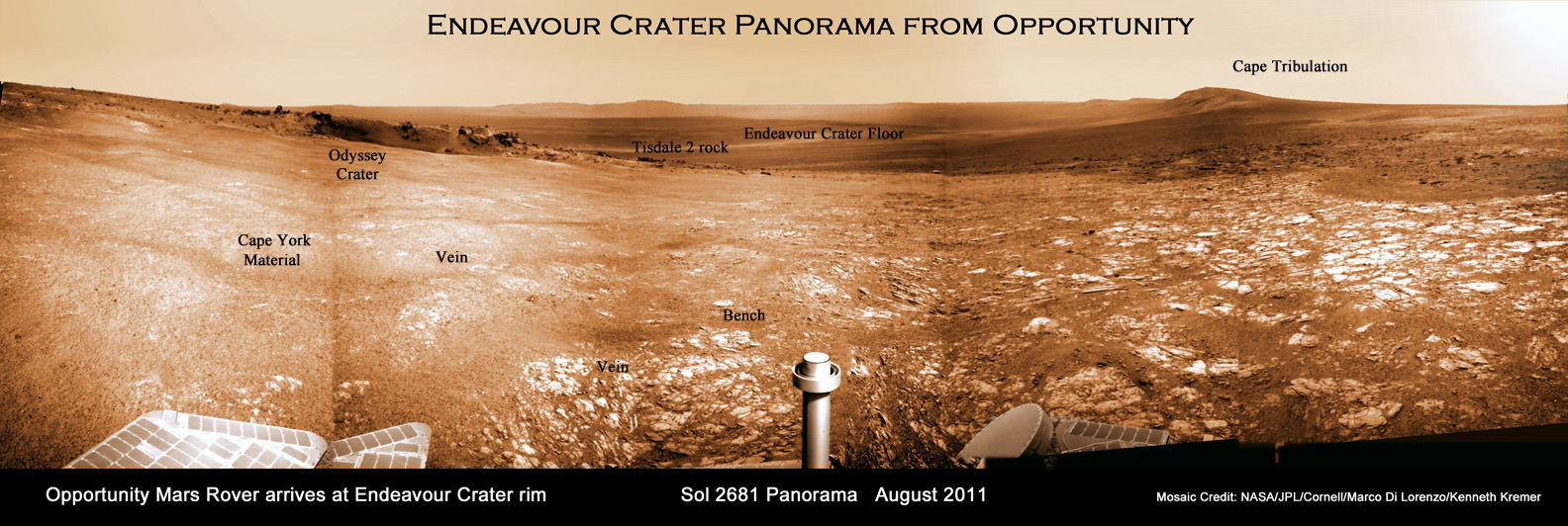
Endeavour Crater Panorama from Opportunity, Sol 2681, August 2011
Opportunity arrived at the rim of Endeavour on Sol 2681, August 9, 2011 and climbed up the ridge known as Cape York. Odyssey crater is visible at left. Opportunity is now driving to the northern tip of Cape York (to the left) and is investigating a geologic vein that indicates flow of liquid water. Opportunity was photographed from Mars orbit on Sept. 10, 2011.
Mosaic Credit: NASA/JPL/Cornell/Marco Di Lorenzo/Kenneth Kremer
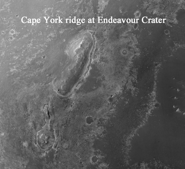
Cape York is a low ridge that belongs to the rim of humongous Endeavour crater, some 14 miles or 22 kilometers in diameter that offers spectacular panoramic vistas peering into the vast and beautiful crater sporting a huge central mound and mountainous rim segments both near and far.
Opportunity arrived at Cape York and Endeavour Crater in August 2011 after an overland expedition of more than 21 miles (34 km).
NASA’s Curiosity rover is on course to liftoff for Mars on Nov. 25
Traverse map showing the 7 Year Journey of Opportunity from Eagle Crater landing site to current location at Cape York ridge at Endeavour Crater rim. Credit: NASA/JPL/Cornell/Marco Di Lorenzo/Kenneth Kremer
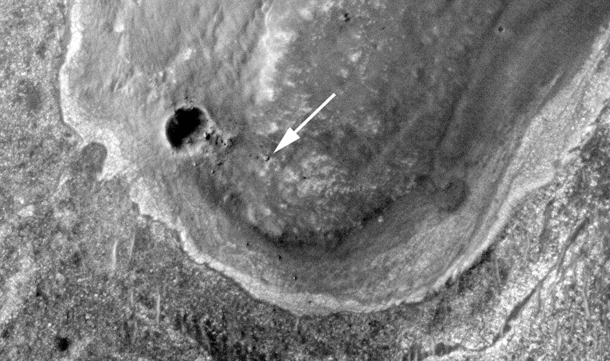
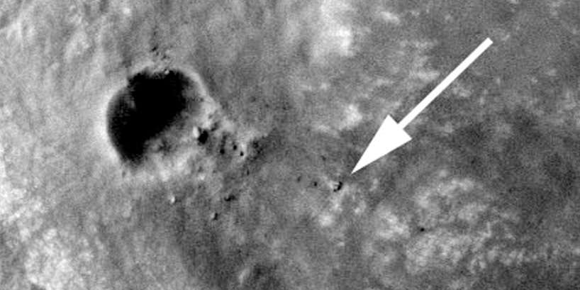
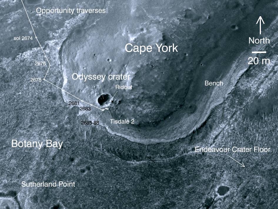
Opportunity captured at Endeavour Crater rim on Sept 10, 2011, Sol 2712. Opportunity is visible at the end of the white arrow, sitting atop some light toned outcrops on the rim of Endeavour Crater located at the southern tip of a rim segment named Cape York. Opportunity is ascending Endeavour at Cape York ridge and positioned to the right of the small crater named Odyssey. This image was taken by the HiRISE camera aboard NASA’s Mars Reconnaissance Orbiter (MRO), Opportunity travelled nearly three years to reach this rim because it contains rocks even more ancient than the rocks of Meridiani Planum, which the rover has been exploring since 2004, and hence may teach us something about an even more ancient era in Martian history. Click to enlarge. Credit: NASA/JPL/University of Arizona
[/caption]
Opportunity has just been imaged in high resolution at Endeavour crater by a powerful NASA camera orbiting overhead in Mars orbit. The new image (see above) was snapped while NASA’s long lived robot was climbing a hilltop offering spectacular panoramic vistas peering into the vast crater which is some 14 miles (22 km) wide.
The HiRiSE camera aboard NASA’s Mars Reconnaissance Orbiter photographed Opportunity and her wheel tracks on September 10, 2011, or Martian Sol 2712 for a mission warrentied to last only 90 Sols ! The rover is sitting to the right of another small crater known as Odyssey. Click to enlarge the image.
Look very closely and you’ll even be able to easily discern the rovers pair of tire tracks showing the path traversed by the robot as she explores the crater and the ejecta rocks and boulders excavated and strewn about by an ancient impact.
Opportunity imaged at Endeavour crater rim with wheel tracks exploring Odyssey crater, rocks and boulders climbing up Cape York ridge. Credit: NASA/JPL/University of Arizona
Opportunity is ascending up the rim of Endeavour crater at the southern tip of a low ridge dubbed Cape York – a location that has already yielded a bonanza of new science data since her recent arrival in August 2011 after a more than 20 mile (33 km) epic trek.
The intrepid rover discovered a rock unlike any other since she safely landed at the Meridiani Planum region of Mars nearly eight years ago on Jan. 24, 2004.
Opportunity is now searching Endeavour crater and Cape York for signatures of phyllosilicates – clay minerals that formed in the presence of pH neutral water flowing on Mars surface billions of years ago. Cape York ridge at Endeavour Crater - From Orbit
This image taken from Mars orbit shows the path driven by NASA's Mars Exploration Rover Opportunity in the weeks around the rover's arrival at the rim of Endeavour crater and up to Sol 2688. Opportunity has since driven a short distance to the right. Credit: NASA/JPL-Caltech/University of Arizona
Endeavour Crater Panorama from Opportunity, Sol 2681, August 2011
Opportunity arrived at the rim of Endeavour on Sol 2681, August 9, 2011 and climbed up the ridge known as Cape York. Odyssey crater is visible at left. Opportunity has since driven a short distance beyond Odyssey crater and was photographed from Mars orbit on Sept. 10, 2011.
Mosaic Credit: NASA/JPL/Cornell/Marco Di Lorenzo/Kenneth Kremer
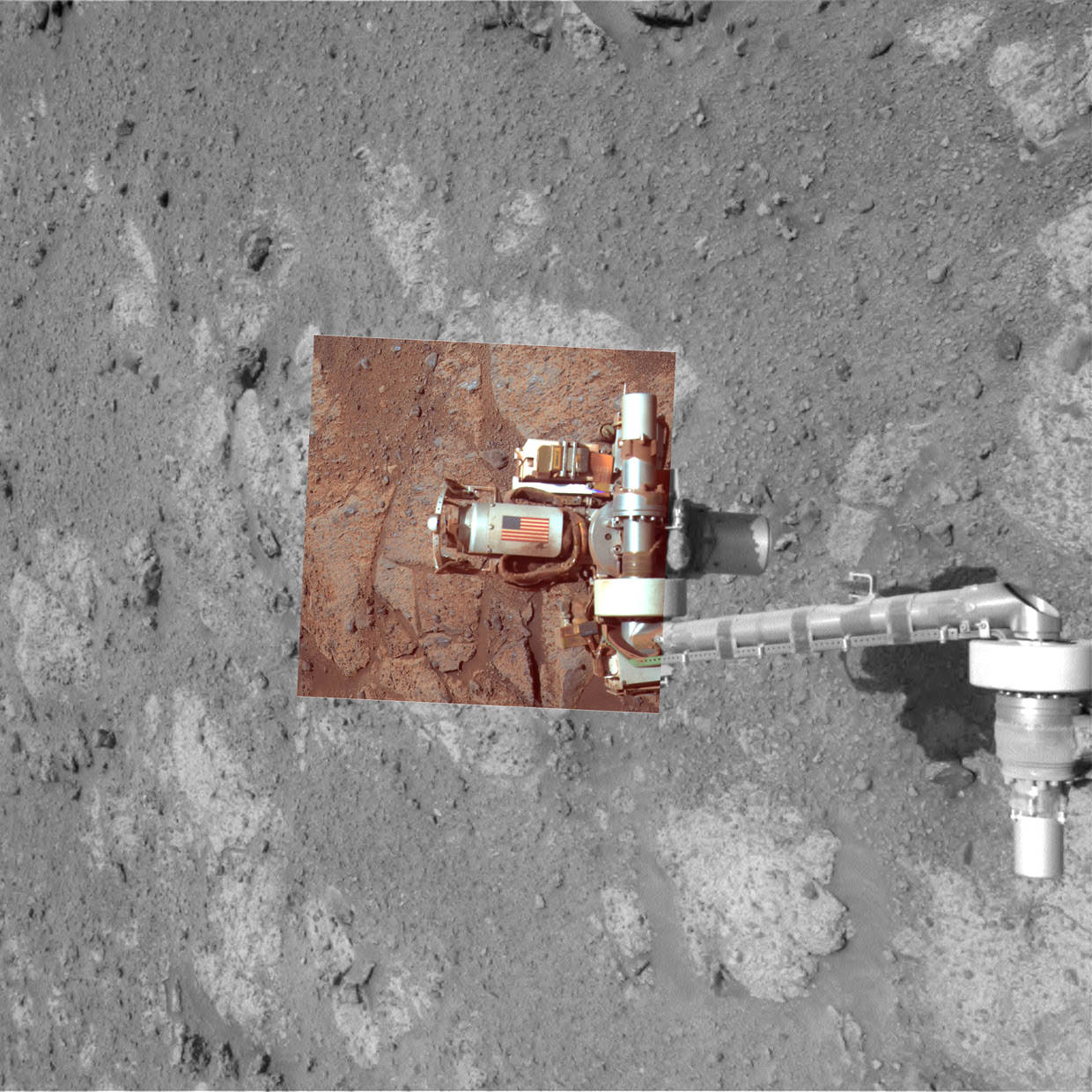
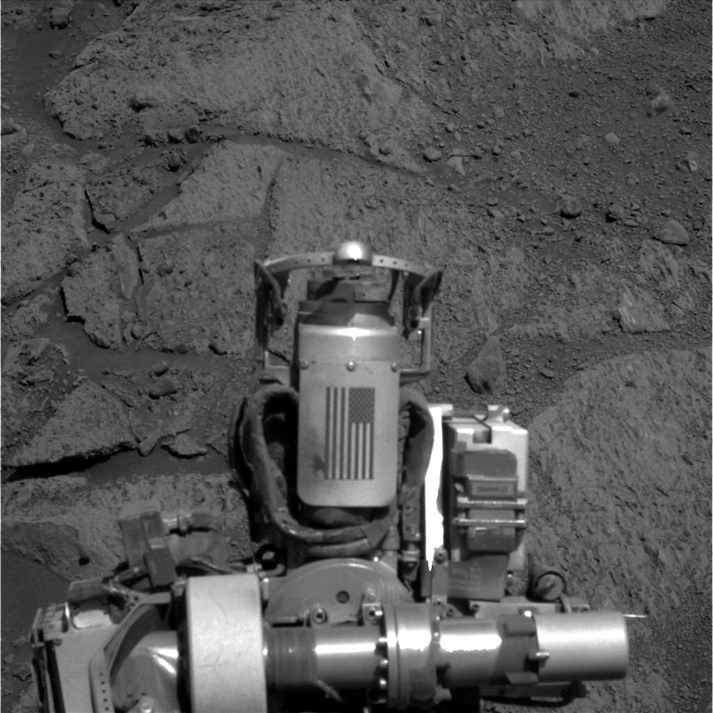
Memorial Image Taken on Mars on Sept. 11, 2011. This view of an American flag on metal recovered from the site of the World Trade Center towers shortly after their destruction on Sept. 11, 2001, was taken on Mars by NASA’s Opportunity rover on Sept. 11, 2011, the 10th anniversary of the attacks on the towers. Credit: NASA/JPL-Caltech/Cornell University/Arizona State University
[/caption]
On this somber occasion marking the 10th anniversary of the tragic events of 9/11, NASA’s Opportunity Mars rover has taken new images of itself on 9/11/11 showing a piece of metal recovered from the wreckage of the Twin Towers of the World Trade Center in New York City that was carried all the way to the planet Mars as a commemorative memorial to the innocent victims of the terrorist attacks of Sept 11, 2001.
On Sept. 11, 2011 (Martian Sol 2713), Opportunity snapped the memorial image above showing the Rock Abrasion Tool (RAT) and an American Flag – evoking the memory of the Twin Towers – from a slope on a Martian hill named Cape York which in turn is a segment of the rim of a gigantic crater named Endeavour.
Opportunity is still roving the red planet’s surface, nearly 8 years after safely landing on Jan 24, 2004. After an epic trek she recently arrived at the gigantic 14 mile wide Endeavour crater .
Opportunity took the new image of the RAT and 9/11 US Flag memorial on Mars on the exact day timed to coincide with the 10th anniversary of the attacks.
The image shows the arm extended for inspection of target on a rock called “Chester Lake”, according to NASA officials. Opportunity is driving in a northerly direction up the Cape York hill on her scientific expedition of the crater’s rim.
Memorial Close-up Image Taken on Mars on Sept. 11, 2011
Close-up image taken on 9/11/11 of a piece of metal with the American flag on it of a NASA’s Opportunity rover on Mars is made of aluminum recovered from the site of the World Trade Center towers in the weeks after their destruction on Sept. 11, 2001. Credit: NASA/JPL-Caltech/Cornell University/Arizona State University
Both towers of the World Trade Center in New York City were destroyed by the terrorists on that terrible day and nearly 3000 precious people were killed during horrifying historic events that changed America and the World forever.
The RAT was built for NASA and both rovers by Honeybee Robotics which at that time was located less than a mile away from the WTC near the southern tip of Manhattan.
Steve Gorevan, the founder and chairman of Honeybee and a member of the rover science team, told me in a past interview that he was on his way to work and out on the city streets within a few blocks of the Twin Towers when he suddenly heard the sounds of the jet engines just before the first tower was struck.
Gorevan and the Honeybee employees watched the tragic events unfold from their company’s offices and rooftop the rest of the day. Following the terror attacks, Gorevan said access to Honeybee was restricted for weeks and the firm was on a tight deadline to deliver the RAT’s to NASA and the Jet Propulsion Laboratory in California where the rovers were being assembled.
The idea for somehow placing a Martian memorial on the rovers was presented. Gorevan told me that he was able to secure metallic pieces from the WTC wreckage through the Office of the then NYC Mayor Rudy Guiliani a few weeks after the attacks.
Memorial Image Taken on Mars on Sept. 11, 2011 of Robotic Arm at Work showing US Flag 9/11 Memorial on the Rock Abrasion Tool (RAT). Image taken on Sol 2713 as the robot investigates a rock outcrop called Chester Lake. Credit: NASA/JPL-Caltech
Aluminum shards were delivered by the Mayor’s office to Honeybee along with a note indicating their authenticity. These were soon fashioned into an aluminum shield that was placed on each RAT along with a US Flag. The shield serves as a cable guard.
Gorevan says the twin towers memorial was purposely kept quiet for some time until well after both rovers landed out of respect for the victims’ families.
Opportunity is healthy and continuing her exploration of Endeavour crater which harbors geologic formations and rocks unlike any previously investigated by either of the Mars Exploration (MER) rovers.
Along the rim of Endeavour crater rover scientists hope to discover and analyze clay minerals which formed in pH neutral water billions of years ago and a habitable environment much more favorable to the formation of life compared to all the other spots studied by either rover thus far.
Both rovers far exceeded their original 90 days warranties with many years of added bonus time for science exploration.
Endeavour Crater Panorama from Opportunity, Sol 2681, August 2011
Opportunity arrived at the rim of Endeavour on Sol 2681, August 9, 2011 and climbed up the ridge known as Cape York. Odyssey crater is visible at left. Opportunity drove north from here to snap a new 9/11 memorial image on Sept 11, 2011 marking the 10th anniversary of the 9/11 terrorist attacks.
Mosaic Credit: NASA/JPL/Cornell/Marco Di Lorenzo/Kenneth Kremer
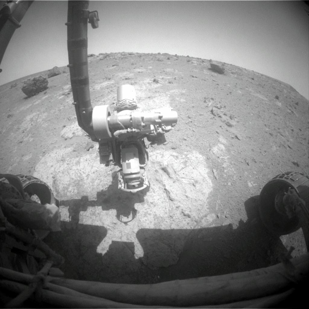
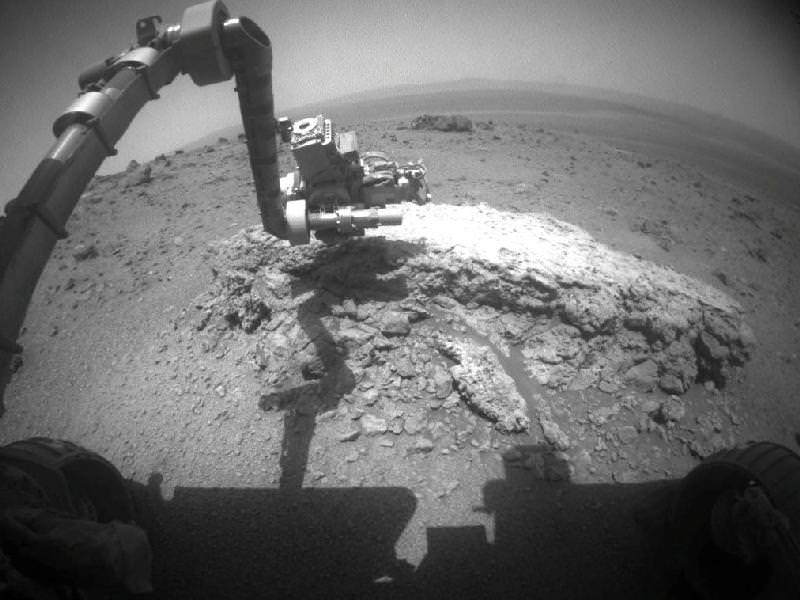
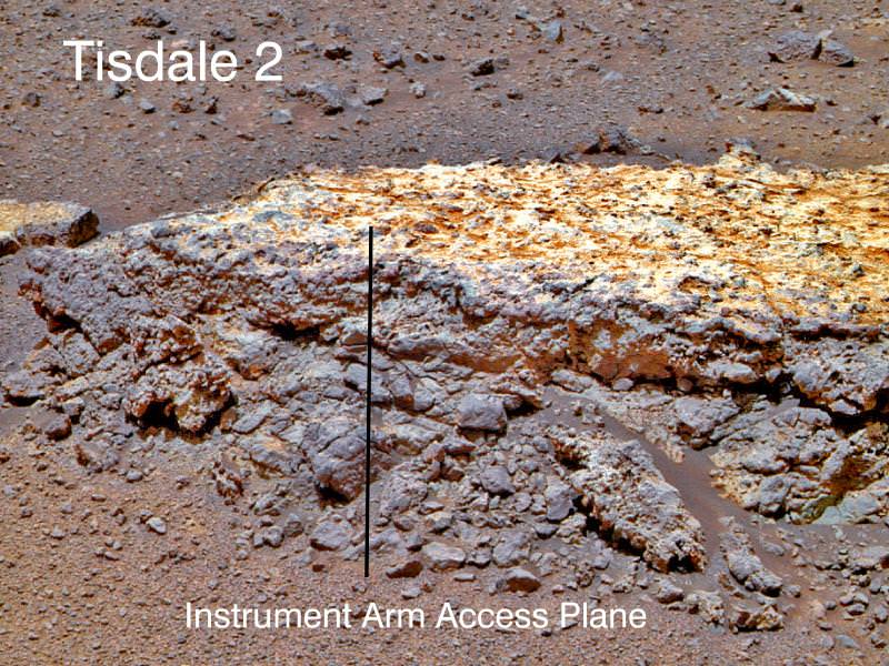
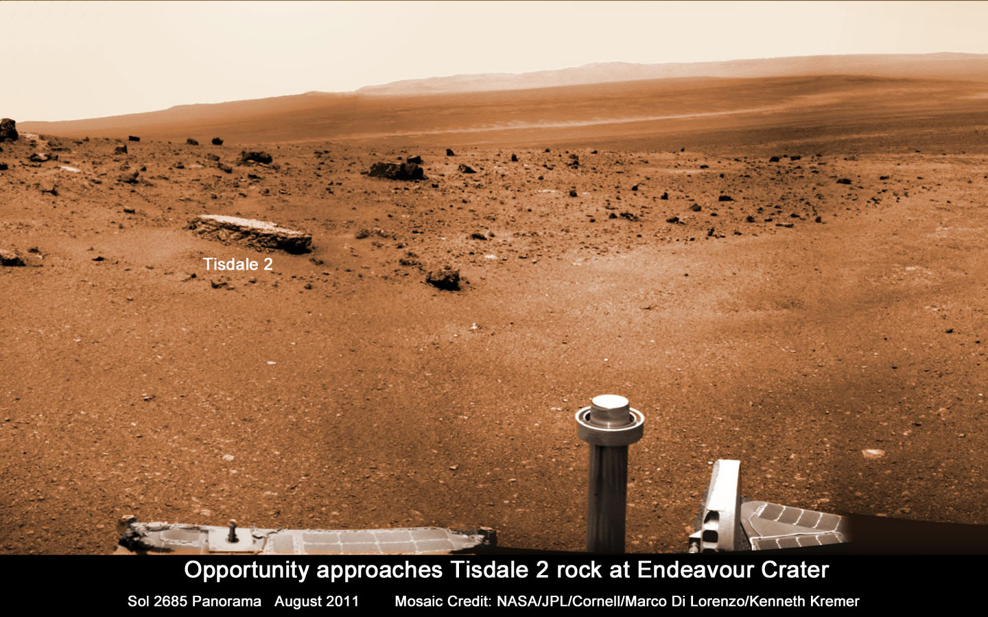
Opportunity investigates Tisdale 2 rock showing indications of ancient Martian water flow. NASA's Mars Exploration Rover Opportunity used its front hazard-avoidance camera to take this picture showing the rover's arm extended toward a light-toned rock, "Tisdale 2," during Sol 2695 of the rover's work on Mars (Aug. 23, 2011). The composition of Tisdale 2 is unlike any rock studied by Opportunity since landing 7.5 years ago. It is about 12 inches (30 centimeters) tall. Credit: NASA/JPL-Caltech
Scientists directing NASA’s Mars Opportunity rover gushed with excitement as they announced that the aging robot has discovered a rock with a composition unlike anything previously explored on the Red Planet’s surface – since she landed on the exotic Martian plains 7.5 years ago – and which offers indications that liquid water might have percolated or flowed at this spot billions of years ago.
Barely three weeks ago Opportunity arrived at the rim of the gigantic 14 mile ( 22 km) wide crater named Endeavour after an epic multi-year trek, and for the team it’s literally been like a 2nd landing on Mars – and the equivalent of the birth of a whole new mission of exploration at an entirely ‘new’ landing site.
“This is like having a brand new landing site for our veteran rover,” said Dave Lavery, program executive for NASA’s Mars Exploration Rovers at NASA Headquarters in Washington. “It is a remarkable bonus that comes from being able to rove on Mars with well-built hardware that lasts.”
Opportunity has traversed an incredible distance of 20.8 miles (33.5 km) across the Meridiani Planum region of Mars since landing on January 24, 2004 for a 3 month mission – now 30 times longer than the original warranty.
“Tisdale 2” is the name of the first rock that Opportunity drove to and investigated after reaching Endeavour crater and climbing up the rim at a low ridge dubbed ‘Cape York’.
This rock, informally named "Tisdale 2," was the first rock the NASA's Mars Rover Opportunity examined in detail on the rim of Endeavour crater. It has textures and composition unlike any rock the rover examined during its first 90 months on Mars. Its characteristics are consistent with the rock being a breccia -- a type of rock fusing together broken fragments of older rocks. Image credit: NASA/JPL-Caltech/Cornell/ASU
Endeavour’s rim is heavily eroded and discontinuous and divided into a series of segmented and beautiful mountainous ridges that offer a bonanza for science.
“This is not like anything we’ve ever seen before. So this is a new kind of rock.” said Steve Squyres, principal investigator for Opportunity at Cornell University in Ithaca, N.Y at a briefing for reporters on Sept. 1.
“It has a composition similar to some volcanic rocks, but there’s much more zinc and bromine than we’ve typically seen. We are getting confirmation that reaching Endeavour really has given us the equivalent of a second landing site for Opportunity.”
Tisdale 2 is a flat-topped rock about the size of a footstool that was blasted free by the impact that formed the tennis court sized “Odyssey” crater from which it was ejected.
“The other big take-away message, and this is to me the most interesting thing about Tisdale, is that this rock has a huge amount of zinc in it, way more zinc than we have ever seen in any Martian rock. And we are puzzling, we are thinking very hard over what that means,” Squyres speculated.
Bright veins cutting across outcrop in a section of Endeavour crater's rim called "Botany Bay" are visible in the foreground and middle distance of this view assembled from images taken by the navigation camera on Opportunity during Sol 2,681on Mars (Aug. 9, 2011). Credit: NASA/JPL-Caltech
Squyres said that high levels of zinc and bromine on Earth are often associated with rocks in contact with flowing water and thus experiencing hydrothermal activity and that the impact is the source of the water.
“When you find rocks on Earth that are rich in zinc, they typically form in a place where you had some kind of hydrothermal activity going on, in other words, you have water that gets heated up and it flows through the rocks and it can dissolve out and it can get redeposited in various places,” Squyres explained.
“So this is a clue, not definitive proof yet, but this is a clue that we may be dealing with a hydrothermal system here, we may be dealing with a situation where water has percolated or flowed or somehow moved through these rocks, maybe as vapor, maybe as liquid, don’t know yet.”
“But it has enhanced the zinc concentration in this rock to levels far in excess of anything we’ve ever seen on Mars before. So that’s the beginning of what we expect is going to be a long and very interesting story about these rocks.”
Endeavour crater was chosen three years ago as the long term destination for Opportunity because it may hold clues to a time billions and billions of years ago when Mars was warmer and wetter and harbored an environment that was far more conducive to the formation of life beyond Earth.
Endeavour Crater Panorama from Opportunity, Sol 2681, August 2011
Opportunity arrived at the rim of Endeavour on Sol 2681, August 9, 2011 and climbed up the ridge known as Cape York. Odyssey crater is visible at left. The rover has driven to Tisdale 2 rock at the outskirts of Odyssey to investigate the ejecta blocks which may hold clues to ancient water flow on Mars. Distant portions of Endeavour’s rim - as far as 13 miles away – visible in the background. The rover will likely drive eventually to the Cape Tribulation rim segment at right which holds a mother lode of clay minerals. This photo mosaic was stitched together from raw images taken by Opportunity on Sol 2681.
Mosaic Credit: NASA/JPL/Cornell/Marco Di Lorenzo/Kenneth Kremer
Signatures of clay minerals, or phyllosilicates, were detected at several spots at Endeavour’s western rim by observations from the Compact Reconnaissance Imaging Spectrometer for Mars (CRISM) aboard NASA’s Mars Reconnaissance Orbiter (MRO).
“The motherlode of clay minerals is on Cape Tribulation. The exposure extends all the way to the top, mainly on the inboard side,” said Ray Arvidson, the rover’s deputy principal investigator at Washington University in St. Louis.
Opportunity Traverse Map: 2004 to 2011. The yellow line on this map shows where NASA's Mars Rover Opportunity has driven from the place where it landed in January 2004 -- inside Eagle crater, at the upper left end of the track -- to a point approaching the rim of Endeavour crater. The map traces the route through the 2,670th Martian day, or sol, of Opportunity's work on Mars (July 29, 2011). Image credit: NASA/JPL-Caltech/MSSS/NMMNHS.
Phyllosilicates are clay minerals that form in the presence of pH neutral water and which are far more hospitable to the possible genesis of life compared to the sulfate rich rocks studied in the more highly acidic aqueous environments examined by both the Opportunity and Spirit rovers thus far.
“We can get up the side of Cape Tribulation,” said Arvidson. It’s not unlike Husband Hill for Spirit. We need to finish up first at Cape York, get through the martian winter and then start working our way south along Solander Point.
The general plan is that Opportunity will probably spend the next several months exploring the Cape York region for before going elsewhere. “Just from Tisdale 2 we know that we have something really new and different here,” said Squyres.
“On the final traverses to Cape York, we saw ragged outcrops at Botany Bay unlike anything Opportunity has seen so far, and a bench around the edge of Cape York looks like sedimentary rock that’s been cut and filled with veins of material possibly delivered by water,” said Arvidson. “We made an explicit decision to examine ancient rocks of Cape York first.”
So far at least the terrain at Cape York looks safe for driving with good prospects for mobility.
Opportunity approaches Tisdale 2 rock at Endeavour Crater rim
Opportunity Mars rover climbed up the ridge known as Cape York and drove to the flat topped Tisdale 2 rock at upper left to analyze it with the science instruments on the robotic arm. This photo mosaic was stitched together from raw images taken by Opportunity on Sol 2685, August 2011.
Mosaic Credit: NASA/JPL/Cornell/Marco Di Lorenzo/Kenneth Kremer
“The good news is that, as predicted, we have hard packed soils like the plains at Gusev that Spirit saw before getting to the Columbia Hills,” said Arvidson. “The wheel tracks at Cape York are very, very shallow. So if anything we will have some skid going downhill the slopes of 5 to 10 degrees on the inboard side which we can correct for.”
“We are always on the lookout for sand traps. We are particularly sensitized to that after the Spirit situation. So far it’s clear sailing ahead.”
Opportunity will then likely head southwards towards an area dubbed “Botany Bay” and eventually drive some 1.5 km further to the next ridge named Cape Tribulation and hopefully scale the slopes in an uphill search for that mother lode of phyllosilicates.
“My strong hope – if the rover lasts that long – is that we will have a vehicle that is capable of climbing Cape Tribulation just as we climbed Husband Hill with Spirit. So it’s obvious to try if the rover is capable, otherwise we would try something simpler. But even if we lose a wheel we still have a vehicle capable of a lot of science,” Squyres emphasized. “Then we would stick to lower ground and more gently sloping stuff.”
“The clear intention as we finish up at Cape York, and look at what to do next, is that we are going to work our way south. We will focus along the crater’s rim. We will work south along the rim of Endeavour unless some discovery unexpectedly causes us to do something else.”
“We will go where the science takes us !” Squyres stated.
Opportunity is in generally good health but the rover is showing signs of aging.
“All in all, we have a very senior rover that’s showing her age, she has some arthritis and some other issues but generally, she’s in good health, she’s sleeping well at night, her cholesterol levels are excellent and so we look forward to productive scientific exploration for the period ahead,” said John Callas, project manager for Opportunity at NASA’s Jet Propulsion Laboratory in Pasadena, Calif.
“This has the potential to be the most revealing destination ever explored by Opportunity,” said Lavery. “This region is substantially different than anything we’ve seen before. We’re looking at this next phase of Opportunity’s exploration as a whole new mission, entering an area that is significantly different in the geologic context than anything we’ve seen with the rovers.”
This image taken from orbit shows the path of the path driven by NASA's Mars Exploration Rover Opportunity in the weeks around the rover's arrival at the rim of Endeavour crater. The sol number (number of Martian days since the rover landed on Mars) are indicated along the route. Sol 2674 corresponds to Aug. 2, 2011; Sol 2688 corresponds to Aug. 16, 2011. Image credit: NASA/JPL-Caltech/University of ArizonaElevated Zinc and Bromine in Tisdale 2 Rock on Endeavour Rim. This graphic presents information gained by examining part of the Martian rock called "Tisdale 2" with the alpha particle X-ray spectrometer on Mars rover Opportunity and comparing the composition measured there with compositions of other targets examined by Opportunity and its rover twin, Spirit. The comparison targets are soil in Gusev crater, examined by Spirit; the relatively fresh basaltic rock Adirondack, examined by Spirit; the stony meteorite Marquette examined by Opportunity; and Gibraltar, an example of sulfate-rich bedrock examined by Opportunity. The target area on Tisdale 2, called "Timmins 1," contains elevated levels of bromine (Br), zinc (Zn), phosphorus (P), sulfur (S) and chlorine (Cl) relative to the non-sulfate-rich comparison rocks, and high levels of zinc and phosphorus relative to Gibraltar. Credit: NASA/JPL-Caltech/Cornell/Max Planck Institute/University of Guelph