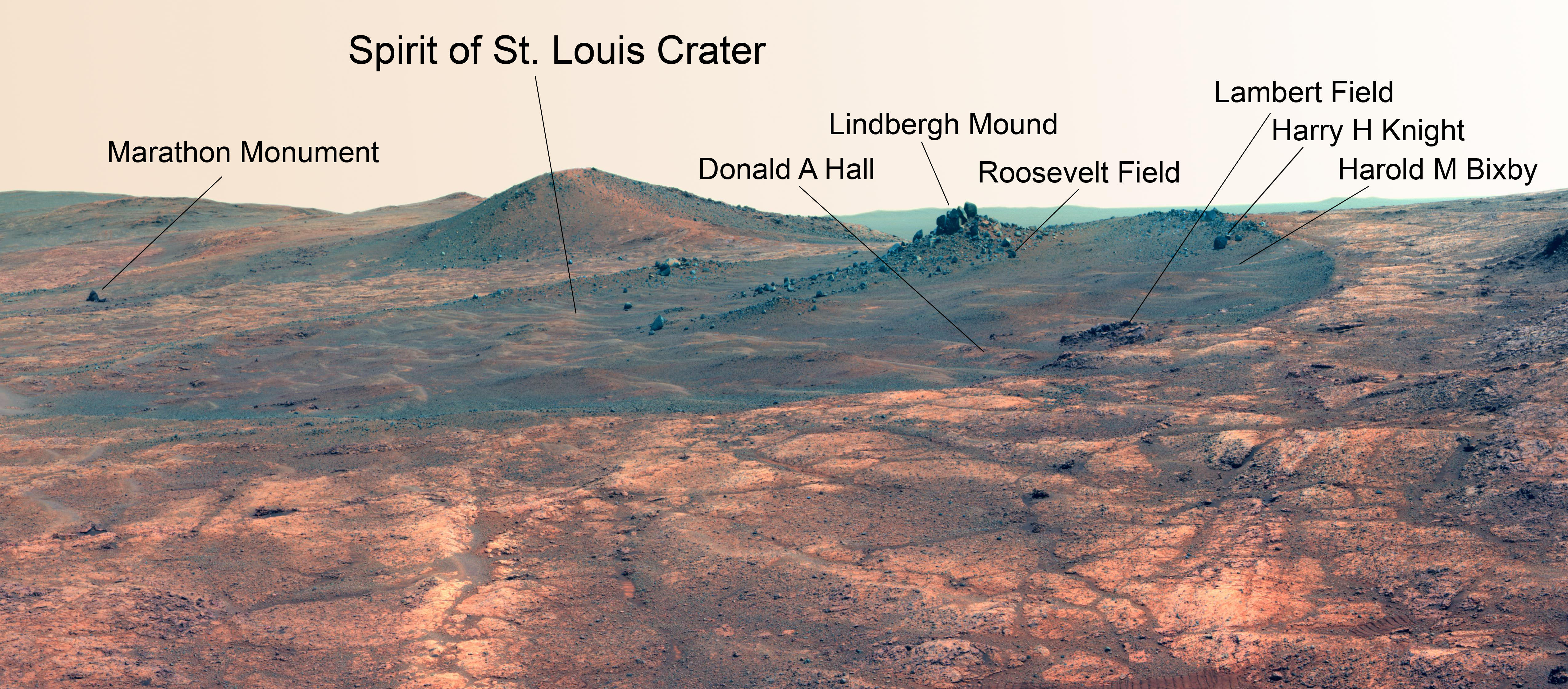
Martian Reminder of a Pioneering Flight. Names related to the first solo nonstop flight across the Atlantic have been informally assigned to a crater NASA's Opportunity Mars rover is studying. This false-color view of the "Spirit of St. Louis Crater" and the "Lindbergh Mound" inside it comes from Opportunity's panoramic camera. Image Credit: NASA/JPL-Caltech/Cornell Univ./Arizona State Univ.
Martian Reminder of a Pioneering Flight. Names related to the first solo nonstop flight across the Atlantic have been informally assigned to a crater NASA’s Opportunity Mars rover is studying. This false-color view of the “Spirit of St. Louis Crater” and the “Lindbergh Mound” inside it comes from Opportunity’s panoramic camera. Image Credit: NASA/JPL-Caltech/Cornell Univ./Arizona State Univ. See additional Opportunity photo mosaics below [/caption]
The science team leading NASA’s long-lived Opportunity rover mission is honoring the pioneering solo nonstop trans-Atlantic flight of aviator Charles Lindbergh by assigning key features of the Mars mountain top crater area the rover is now exploring with names related to the historic flight.
Opportunity is now studying an elongated crater called “Spirit of St. Louis” and an unparalleled rock spire within the crater called “Lindbergh Mound” which are named in honor of Lindbergh himself and his plane – the Spirit of Saint Louis.
“Spirit of Saint Louis” crater is quite special in many ways related not just to history but also to science and exploration – that very reasons behind Lindbergh’s flight and Opportunity’s astounding mission to the Red Planet.
The team is ecstatic that the 11 year old rover Opportunity has reached “Spirit of St. Louis Crater” because its serves as the gateway to the alien terrain of “Marathon Valley” holding caches of water altered minerals that formed under environmental conditions conducive to support Martian microbial life forms, if they ever existed.
The crater, rock spire and several features in and near it are shown in several recent panoramic mosaics, above and below, created by the rover team and separately by the image processing team of Ken Kremer and Marco Di Lorenzo.
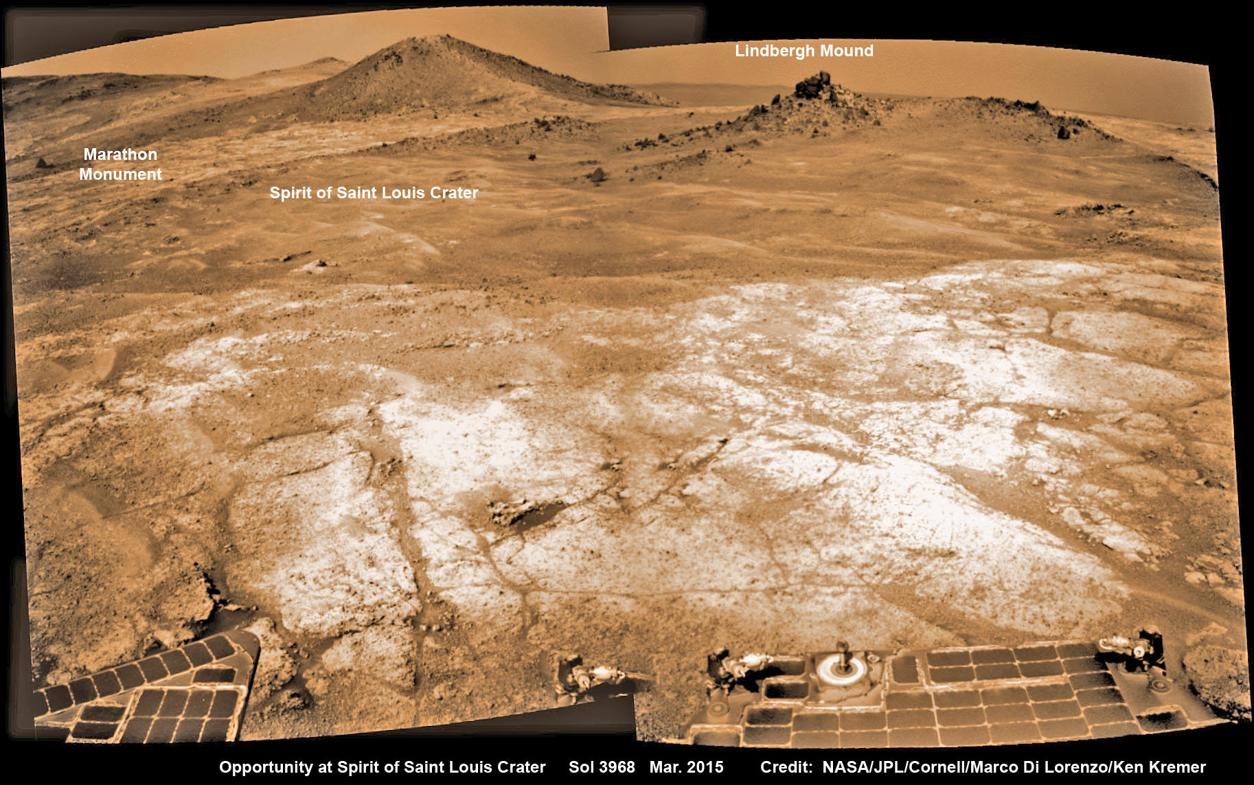
Opportunity’s view (annotated) on the day the NASA rover exceeded the distance of a marathon on the surface of Mars on March 24, 2015, Sol 3968 with features named in honor of Charles Lindbergh’s historic solo flight across the Atlantic Ocean in 1927. Rover stands at Spirit of Saint Louis Crater near mountaintop at Marathon Valley overlook and Martian cliffs at Endeavour crater holding deposits of water altered clay minerals. This navcam camera photo mosaic was assembled from images taken on Sol 3968 (March 24, 2015) and colorized. Credit: NASA/JPL/Cornell/Marco Di Lorenzo/Ken Kremer/kenkremer.com
Marathon Valley and Spirit of St. Louis Crater are located just a few hundred meters south of a Mars mountain summit at a majestic spot called Cape Tribulation. It lies along a marvelous ridgeline along the western rim of Endeavour crater, which spans some 22 kilometers (14 miles) in diameter.
“What’s the connection between St. Louis and the Spirit of St. Louis? Lindbergh flew from New York to Paris, but he named his aircraft for the St. Louis citizens who purchased it for him,” says Prof. Ray Arvidson, the rover Deputy Principal Investigator of Washington University in St. Louis.
The raw images for the mosaics were taken in March and April 2015 using the robots mast mounted pancam and navcam cameras. The mosaics are shown in false color and colorized versions, annotated and unannotated.
Charles Lindbergh embarked in May 1927 on his history making flight from New York to Paris in the airplane he named Spirit of St. Louis, the first solo nonstop flight across the Atlantic.
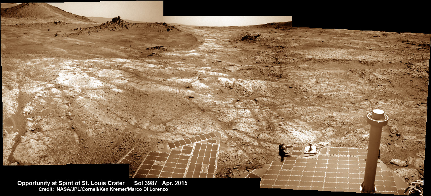
Opportunity at Spirit of Saint Louis crater scanning into Marathon Valley and Endeavour crater from current location on Mars in April 2015 in this photo mosaic. The crater, featuring an odd mound of rocks now named Lingbergh Mound, is the gateway to Marathon Valley and exposures of water altered clay minerals. This navcam camera photo mosaic was assembled from images taken on Sol 3987 (April 12, 2015) and colorized. Credit: NASA/JPL/Cornell/ Ken Kremer/kenkremer.com/Marco Di Lorenzo
The shallow Spirit of St. Louis Crater is about 110 feet (34 meters) long and about 80 feet (24 meters) wide, with a floor slightly darker than surrounding terrain, says NASA.
Lindbergh Mound dominates the crater measuring about 7 to 10 feet (2 to 3 meters) tall, rising higher than the crater’s rim.
The annotations also include features named to recognize the financial backing for the flight from St. Louis residents including Harold M. Bixby and Harry M. Knight. The plane’s designer was Donald A. Hall.
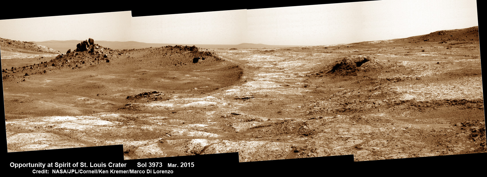
Opportunity arrives at Spirit of Saint Louis crater and peers into Marathon Valley and Endeavour crater from current location on Mars as of April 3, 2015 in this photo mosaic. The crater, featuring an odd mound of rocks now named Lingbergh Mound, is the gateway to Marathon Valley and exposures of water altered clay minerals. This pancam camera photo mosaic was assembled from images taken on Sol 3973 (March 29, 2015) and colorized. Credit: NASA/JPL/Cornell/ Ken Kremer/kenkremer.com/Marco Di Lorenzo
Among other features named are Roosevelt Field, the spot on New York’s Long Island from which Lindbergh took off, and Marathon Monument, where the rover completed a her first marathon distance runners drive on Mars. The team picked a distinctive outcrop, Marathon Monument, to mark the finish line, said NASA officials.
“The science team for the rover picks crater names from a list of “vessels of exploration,” including ships of sail and spacecraft as well as aircraft. As long as the rover remains in the crater, names for interesting features will drawn from a list of names related to this famous flight,” according to a NASA statement.
Stay tuned here for Ken’s continuing Earth and planetary science and human spaceflight news.
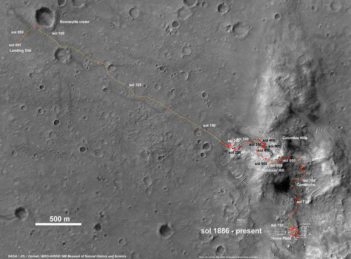
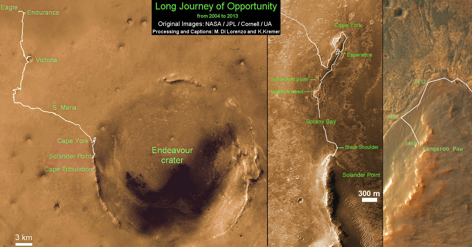
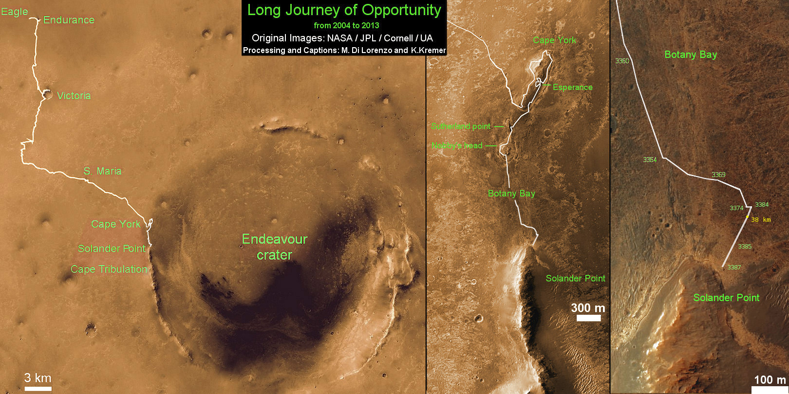
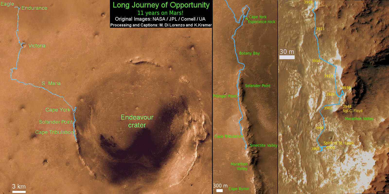
11 Year Traverse Map for NASA’s Opportunity rover from 2004 to 2015. This map shows the entire path the rover has driven during 11 years and three months and a marathon runners distance on Mars for over 4000 Sols, or Martian days, since landing inside Eagle Crater on Jan 24, 2004 -to current location just past the Cape Tribulation summit at the western rim of Endeavour Crater at Marathon Valley. Rover surpassed Marathon distance on Sol 3968 and marked 11th Martian anniversary on Sol 3911. Opportunity discovered clay minerals at Esperance – indicative of a habitable zone – and is searching for more on the road ahead at Marathon Valley. Credit: NASA/JPL/Cornell/ASU/Marco Di Lorenzo/Ken Kremer – kenkremer.com
Credit: NASA/JPL-Caltech/Cornell University/Arizona State University. Colorization by Stuart Atkinson.
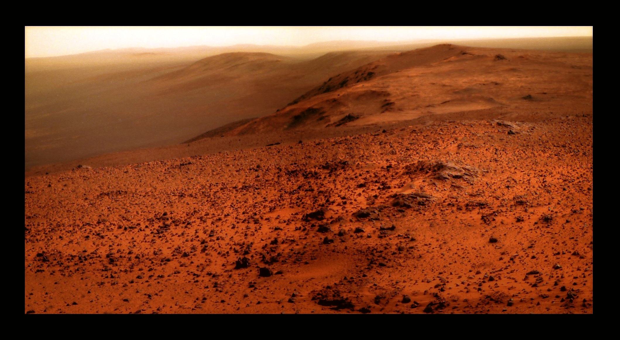
Imagine if you were standing on Mars, beside the Opportunity rover, high on the summit of Cape Tribulation. You don’t have to leave too much to the imagination, thanks to imaging enthusiast Stu Atkinson. He’s put together a magnificent colorized version of Oppy’s recent panoramic view, atop the highest elevation that the rover will ever reach, perched on the west rim of Endeavour crater.
Click the image for the full view.
It’s quite the spectacular view for the rover that keeps going and going, with over 11 years of trekking across Mars. You can see haze and hills off in the distance, and a horizon that continues to beckon. According to Larry Crumpler from the MER science team, if you look closely at the image — from Oppy’s viewpoint — you can see all the way to the other side of the crater.
“We can see the rim looking north along the path to this location, and we can see far to the south, including another large impact crater that lies 10 km or so south of Endeavour,” Crumpler wrote in the rover field reports published on the New Mexico Museum of Natural History & Science’s website.
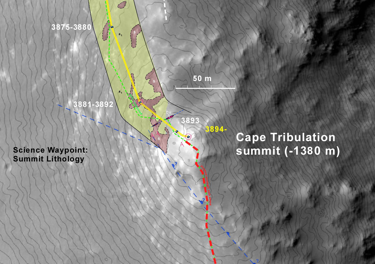
Here’s a map created by Crumpler of the Opportunity rover’s location at Cape Tribulation:
A map showing the location on the local summit of Cape Tribulation (1 m contours) and the geology up to this location. Credit: Larry Crumpler/MER Science Team/New Mexico Museum of Natural History & Science.
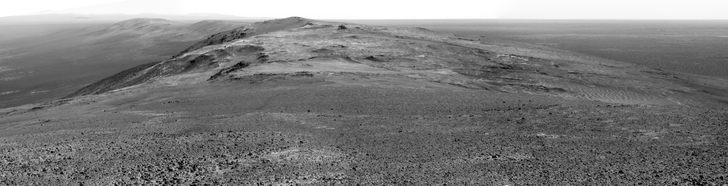
And here’s the black and white panorama from Arizona State Univerity:
Sol 3906, January 19, 2015. Summit panorama from Cape Tribulation from the Opportunity Mars Rover. Credit: NASA/Arizona State University.
Stu wrote poetically about the image on his website, explaining that the rover is looking down from the summit of Cape Tribulation, “with gorgeous views of the rim of Endeavour on the farside of the crater and of her tracks leading back down the hill to the great Merdiani Plain far below.”
Stu also explained his motivation for the work he does in enhancing the raw images sent from Mars:
What I try to create with my images is a vision of Mars, something that puts across – hopefully – the beauty of the planet and its landscapes. So my images are not photo-realistic, and I don’t claim them to be, but they, I hope, one person’s depiction of Mars which reflect the planet’s incredible raw beauty and nobility.
We only hope Stu, that like the rover, you keep going and going with your image processing wizardry too!
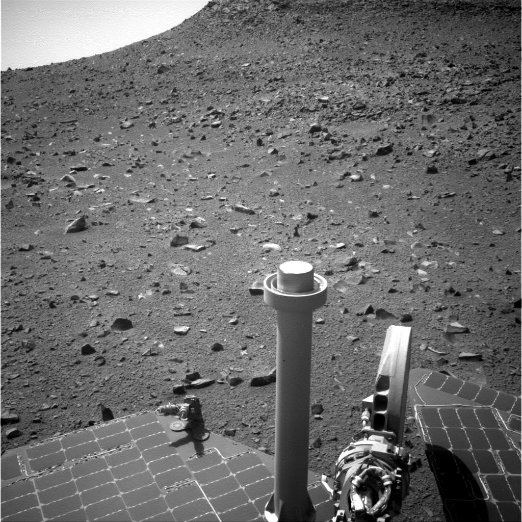
The Opportunity rover is at the west rim of Endeavour Crater on Mars in this image sent on Sol 3,783 in September 2014 -- after a successful Flash memory reset. Credit: NASA/JPL-Caltech/Cornell Univ./Arizona State Univ.
With a newly cleared memory, it’s time for Opportunity to resume the next stage of its long, long Martian drive. The next major goal for the long-lived rover is to go to Marathon Valley, a spot that (in images from orbit) appears to have clay minerals on site. Clay tends to form in the presence of water, so examining the region could provide more information about Mars’ wet, ancient past.
Ready to roll: the Opportunity rover’s wheels and tracks are visible in this picture taken on Mars on Sol 3,783 in September 2014. Credit: NASA/JPL-Caltech/Cornell Univ./Arizona State Univ.
A NASA planetary senior review panel from early September, which was evaluating the science value of several extended missions, said there are “software and communication issues that afflict the rover” that could affect its ability to send data. (This was written before the memory reformat.)
The major goal of Opportunity’s latest extended mission, the review continued, is to find out what habitability conditions existed on Mars. This includes looking at the water, the geology and the environment.
“This will be achieved by measurements of rocks and soils, as well as atmospheric observations, as it traverses from Murray Ridge to Cape Tribulation,” the report read.
A still from the Opportunity rover’s navigation camera taken on Sol 3,783 in September 2014. At bottom is part of the solar panel cells used to power the Martian rover. Credit: NASA/JPL-Caltech/Cornell Univ./Arizona State Univ.
“This extended mission will focus on the orbitally detected phyllosilicate deposits near Endeavour crater, which are considered to represent deposits from the ancient Noachian period. This would represent the first time that such ancient deposits have been analyzed on the Martian surface.”
The report further cautioned that there is no proof yet that the phyllosilicates (which are sheet salt silicate materials made of silicon and oxygen) are from the Noachian era, which represents geology that is more than 3.5 billion years old (depending on which source you consult). It added, however, that Opportunity is expected to be able to complete the science.
Meanwhile, enjoy these pictures from the rim of Endeavour Crater that Opportunity sent in the past few days.
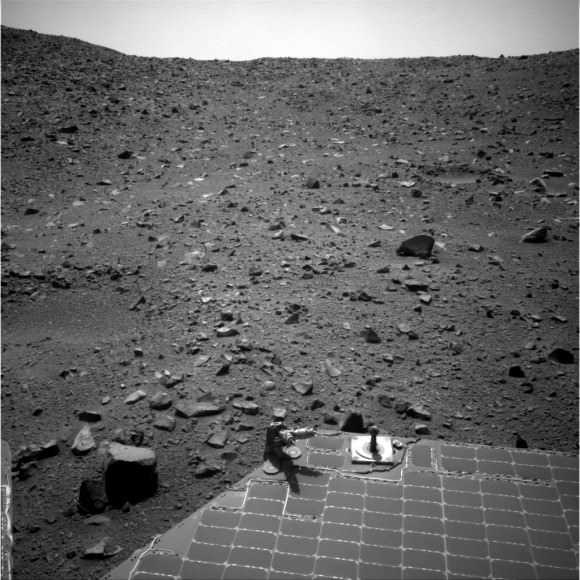
Rocks scattered across the Martian vista in this picture captured by the Opportunity rover on Sol 3,783. Credit: NASA/JPL-Caltech/Cornell Univ./Arizona State Univ.Two of Opportunity’s six wheels are visible in this shot from the rear hazcam on Sol 3,780, taken on Mars in September 2014. Credit: NASA/JPL-Caltech/Cornell Univ./Arizona State Univ.Tracks from Opportunity stretch across this vista taken by the rover on Sol 3,781 in September 2014. Credit: NASA/JPL-Caltech/Cornell Univ./Arizona State Univ.
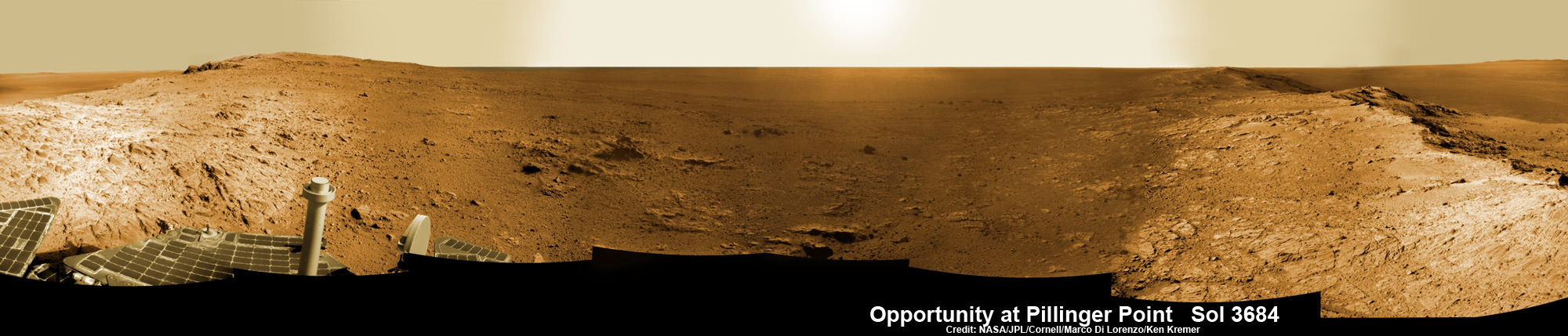
Opportunity Mars rover peers into vast Endeavour Crater from Pillinger Point mountain ridge named in honor of Colin Pillinger, the Principal Investigator for the British Beagle 2 lander built to search for life on Mars. Pillinger passed away from a brain hemorrhage on May 7, 2014. This navcam camera photo mosaic was assembled from images taken on June 5, 2014 (Sol 3684) and colorized. Credit: NASA/JPL/Cornell/Marco Di Lorenzo/Ken Kremer-kenkremer.com
NASA’s decade old Opportunity rover has reached a long sought after region of aluminum-rich clay mineral outcrops at a new Endeavour crater ridge now “named ‘Pillinger Point’ after Colin Pillinger the Principal Investigator for the [British] Beagle 2 Mars lander”, Prof. Ray Arvidson, Deputy Principal Investigator for the rover, told Universe Today exclusively. See above the spectacular panoramic view from ‘Pillinger Point’ – where ancient water once flowed billions of year ago.
The Beagle 2 lander was built to search for signs of life on Mars.
The Mars Exploration Rover (MER) team named the noteworthy ridge in honor of Prof. Colin Pillinger – a British planetary scientist at the Open University in Milton Keynes, who passed away at the age of 70 on May 7, 2014.
‘Pillinger Point’ is a scientifically bountiful place possessing both clay mineral outcrops and mineral veins where “waters came up through the cracks”, Arvidson explained to me.
Since water is a prerequisite for life as we know it, this is a truly fitting tribute to name Opportunity’s current exploration site ‘Pillinger Point’ after Prof. Pillinger.
See our new photo mosaic above captured by Opportunity peering out from ‘Pillinger Point’ ridge on June 5, 2014 (Sol 3684) and showing a panoramic view around the eroded mountain ridge and into vast Endeavour crater.
The gigantic crater spans 14 miles (22 kilometers) in diameter.
See below our Opportunity 10 Year traverse map showing the location of Pillinger Point along the segmented rim of Endeavour crater.
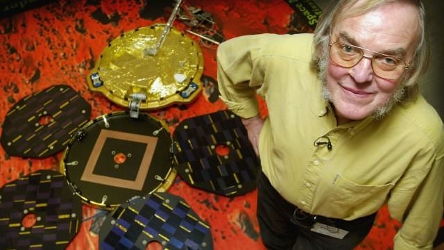
British planetary scientist Colin Pillinger with the Beagle 2 lander.
Pillinger Point is situated south of Solander Point and Murray Ridge along the western rim of Endeavour in a region with caches of clay minerals indicative of an ancient Martian habitable zone.
For the past several months, the six wheeled robot has been trekking southwards from Solander towards the exposures of aluminum-rich clays – now named Pillinger Point- detected from orbit by the CRISM spectrometer aboard NASA’s powerful Martian ‘Spysat’ – the Mars Reconnaissance Orbiter (MRO) – while gathering context data at rock outcrops along the winding way.
“We are about 3/5 of the way along the outcrops that show an Al-OH [aluminum-hydroxl] montmorillonite [clay mineral] signature at 2.2 micrometers from CRISM along track oversampled data,” Arvidson told me.
“We have another ~160 meters to go before reaching a break in the outcrops and a broad valley.”
The rover mission scientists ultimate goal is travel even further south to ‘Cape Tribulation’ which holds a motherlode of the ‘phyllosilicate’ clay minerals based on extensive CRISM measurements accomplished earlier at Arvidson’s direction.
“The idea is to characterize the outcrops as we go and then once we reach the valley travel quickly to Cape Tribulation and the smectite valley, which is still ~2 km to the south of the present rover location,” Arvidson explained.
Mars Express and Beagle 2 were launched in 2003, the same year as NASA’s twin rovers Spirit and Opportunity, on their interplanetary voyages to help unlock the mysteries of Mars potential for supporting microbial life forms.
Pillinger was the driving force behind the British built Beagle 2 lander which flew to the Red Planet piggybacked on ESA’s Mars Express orbiter. Unfortunately Beagle 2 vanished without a trace after being deployed from the orbiter on Dec. 19, 2003 with an expected air bag assisted landing on Christmas Day, Dec. 25, 2003.
In an obituary by the BBC, Dr David Parker, the chief executive of the UK Space Agency, said that Prof. Pillinger had played a critical role in raising the profile of the British space programme and had inspired “young people to dream big dreams”.
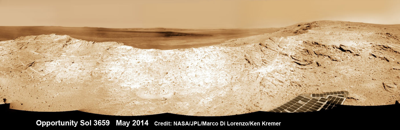
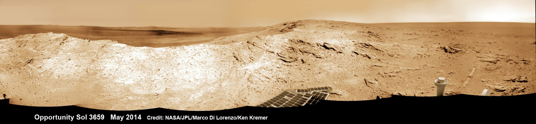
NASA’s Opportunity Mars rover captures sweeping panoramic vista near the ridgeline of 22 km (14 mi) wide Endeavour Crater’s western rim. The center is southeastward and also clearly shows the distant rim. See the complete panorama below. This navcam panorama was stitched from images taken on May 10, 2014 (Sol 3659) and colorized. Credit: NASA/JPL/Cornell/Marco Di Lorenzo/Ken Kremer-kenkremer.com
During his distinguished career Pillinger also analyzed lunar rock samples from NASA’s Apollo moon landing missions and worked on ESA’s Rosetta mission.
“It’s important to note that Colin’s contribution to planetary science goes back to working on Moon samples from Apollo, as well as his work on meteorites,” Dr Parker told the BBC.
Today, June 16, marks Opportunity’s 3696th Sol or Martian Day roving Mars – compared to a warranty of just 90 Sols.
So far she has snapped over 193,400 amazing images on the first overland expedition across the Red Planet.
Her total odometry stands at over 24.51 miles (39.44 kilometers) since touchdown on Jan. 24, 2004 at Meridiani Planum.
NASA’s Opportunity Mars rover captures sweeping panoramic vista near the ridgeline of 22 km (14 mi) wide Endeavour Crater’s western rim. The center is southeastward and the distant rim is visible in the center. An outcrop area targeted for the rover to study is at right of ridge. This navcam panorama was stitched from images taken on May 10, 2014 (Sol 3659) and colorized. Credit: NASA/JPL/Cornell/Marco Di Lorenzo/Ken Kremer-kenkremer.com
Meanwhile on the opposite side of Mars, Opportunity’s younger sister rover Curiosity is trekking towards gigantic Mount Sharp after drilling into her 3rd Red Planet rock at Kimberley.
Stay tuned here for Ken’s continuing Curiosity, Opportunity, Orion, SpaceX, Boeing, Orbital Sciences, MAVEN, MOM, Mars and more planetary and human spaceflight news.
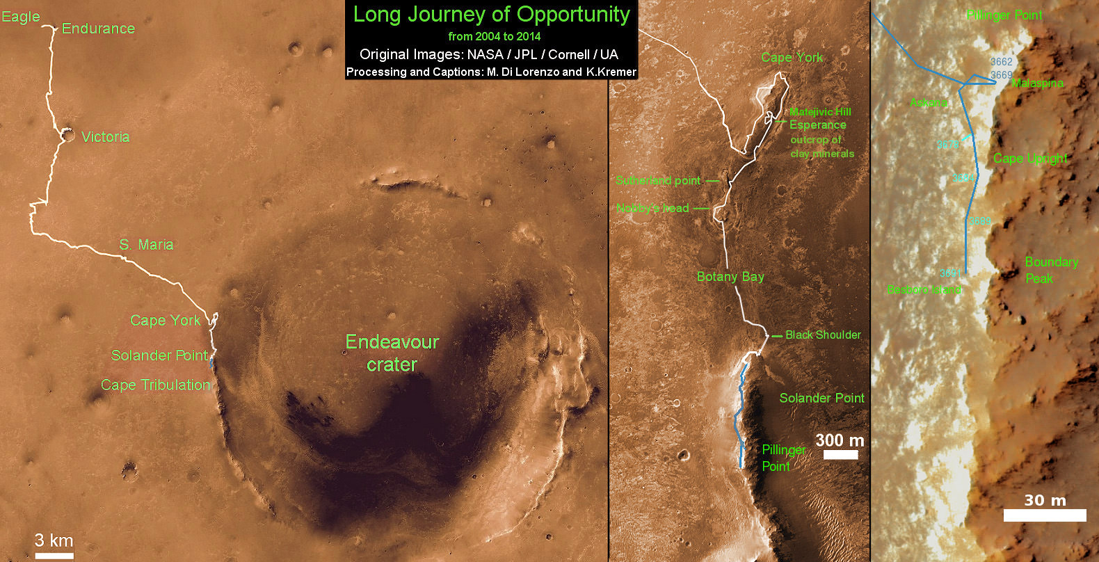
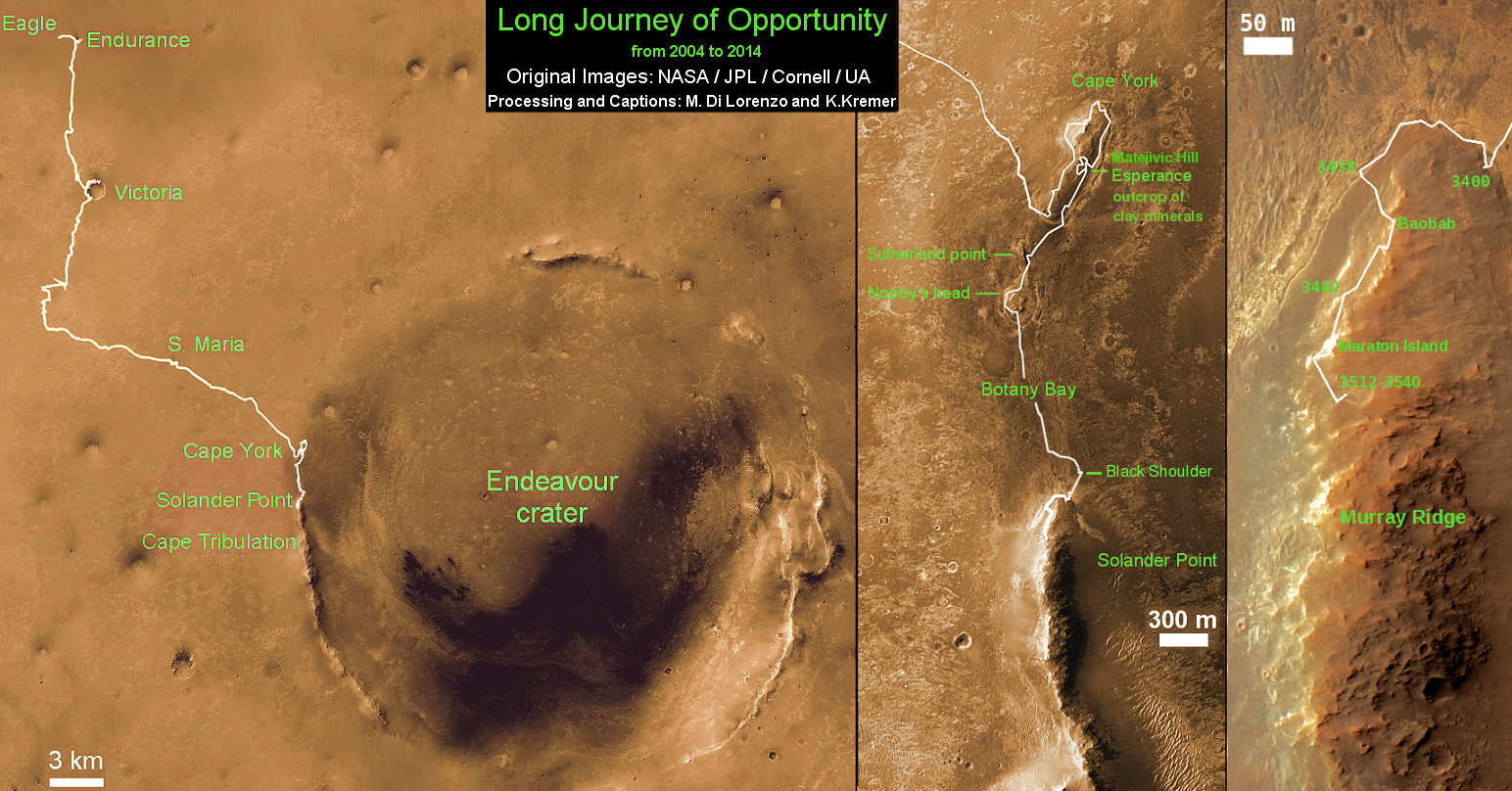
Traverse Map for NASA’s Opportunity rover from 2004 to 2014 – A Decade on Mars
This map shows the entire path the rover has driven during a decade on Mars and over 3692 Sols, or Martian days, since landing inside Eagle Crater on Jan 24, 2004 to current location along Pillinger Point ridge south of Solander Point summit at the western rim of Endeavour Crater and heading to clay minerals at Cape Tribulation. Opportunity discovered clay minerals at Esperance – indicative of a habitable zone. Credit: NASA/JPL/Cornell/ASU/Marco Di Lorenzo/Ken Kremer
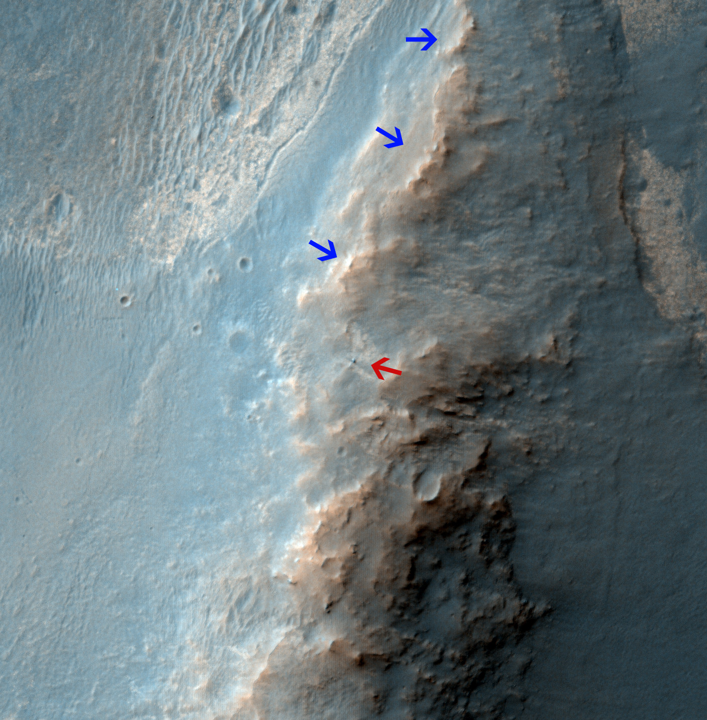
Opportunity Rover on 'Murray Ridge' Seen From Orbit on Valentine’s Day 2014 . The telescopic High Resolution Imaging Science Experiment (HiRISE) camera on NASA's Mars Reconnaissance Orbiter caught this view of NASA's Mars Exploration Rover Opportunity on Feb. 14, 2014 by the summit of Solander Point. The red arrow points to Opportunity at the center of the image. Blue arrows point to tracks left by the rover since it entered the area seen here, in October 2013. The scene covers a patch of ground about one-quarter mile (about 400 meters) wide. North is toward the top. The location is the "Murray Ridge" section of the western rim of Endeavour Crater. Credit: NASA/JPL-Caltech/Univ. of Arizona
Opportunity Rover on ‘Murray Ridge’ Seen From Orbit on Valentine’s Day 2014
The telescopic High Resolution Imaging Science Experiment (HiRISE) camera on NASA’s Mars Reconnaissance Orbiter caught this view of NASA’s Mars Exploration Rover Opportunity on Feb. 14, 2014 by the summit of Solander Point. The red arrow points to Opportunity at the center of the image. Blue arrows point to tracks left by the rover since it entered the area seen here, in October 2013. The scene covers a patch of ground about one-quarter mile (about 400 meters) wide. North is toward the top. The location is the “Murray Ridge” section of the western rim of Endeavour Crater. Credit: NASA/JPL-Caltech/Univ. of Arizona See below corresponding surface view snapped by Opportunity from this location[/caption]
NASA’s renowned Mars rover Opportunity has been spied anew in a fabulous new photo captured just days ago by NASA’s ‘Spy in the Sky’ orbiter circling overhead the Red Planet. See Opportunity from above and below – from today’s location. See orbital view above – just released today.
The highly detailed image was freshly taken on Feb. 14 (Valentine’s Day 2014) by the telescopic High Resolution Imaging Science Experiment (HiRISE) camera on NASA’s Mars Reconnaissance Orbiter (MRO) as the decade old Opportunity was investigating the tasty alien terrain on ‘Murray Ridge’ – nearby the celebrated ‘jelly doughnut’ rock by the summit of Solander Point. See surface views below.
The fabulous orbital image shows not only rover Opportunity at her location today, but also the breathtaking landscape around the robots current location as well as some of the wheel tracks created by the Martian mountaineer as she climbed from the plains below up to near the peak of Solander Point.
The scene is narrowly focused on a spot barely one-quarter mile (400 meters) wide.
Murray Ridge and Solander Point lie at the western rim of a vast crater named Endeavour that spans some 22 kilometers (14 miles) in diameter.
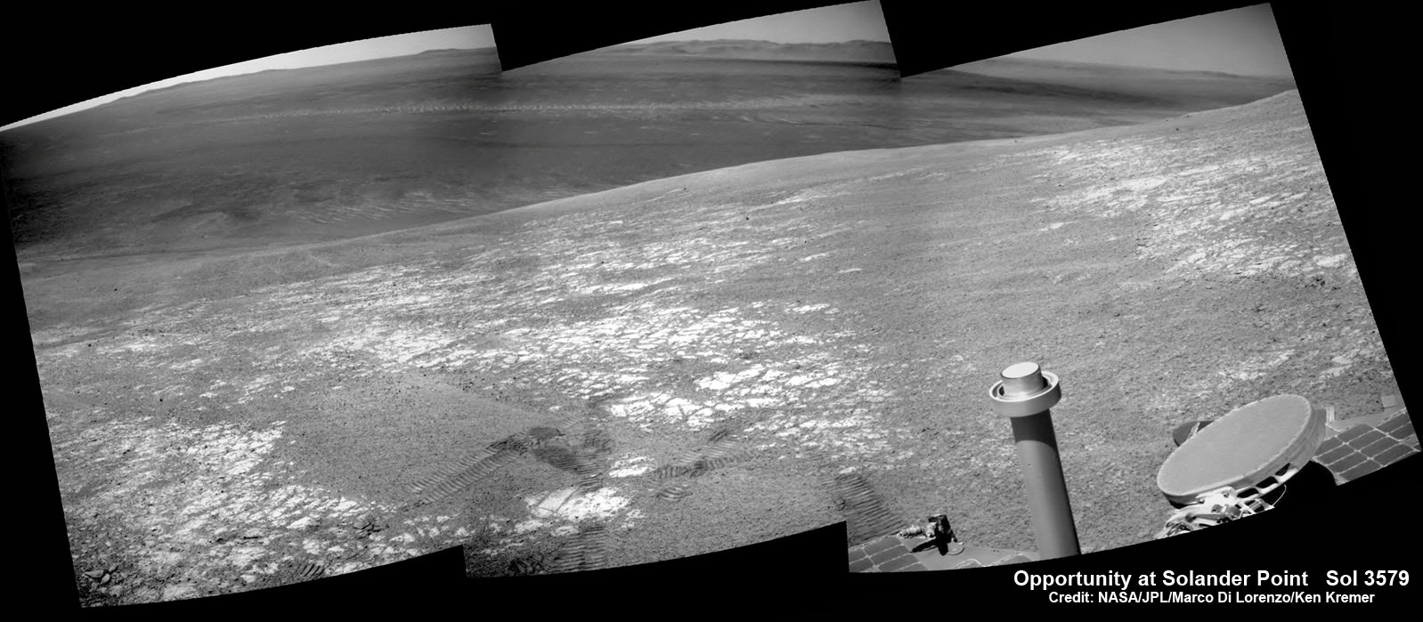
Here is the corresponding Martian surface view snapped by Opportunity on Feb. 16, 2014 (looking back and down to Endeavour crater), while she’s being imaged from Mars orbit on Feb. 14, 2014:
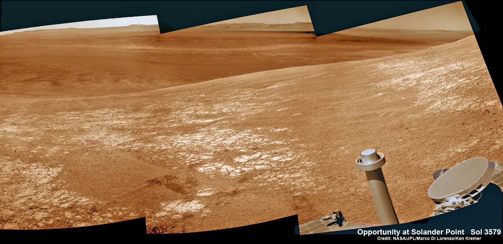
NASA’s Opportunity rover was imaged here from Mars orbit by MRO HiRISE camera on Feb. 14, 2014. This mosaic shows Opportunity’s view today while looking back to vast Endeavour crater from atop Murray Ridge by summit of Solander Point. Opportunity captured this photomosaic view on Feb. 16, 2014 (Sol 3579) from the western rim of Endeavour Crater where she is investigating outcrops of potential clay minerals formed in liquid water. Assembled from Sol 3579 colorized navcam raw images. Credit: NASA/JPL/Cornell/Marco Di Lorenzo/Ken Kremer-kenkremer.com
Endeavour is an impact scar created billions of years ago. See our 10 Year Opportunity traverse map below.
And believe it or not, that infamous ‘jelly doughnut’ rock was actually the impetus for this new imaging campaign by NASA’s MRO Martian ‘Spysat.’
To help solve the mystery of the origin of the shiny 1.5 inches wide (4 centimeters) ‘jelly doughnut’ rock, dubbed ‘Pinnacle Island’, the science team decided to enlist the unparalleled capabilities of the HiRISE camera and imaging team in pursuit of answers.
Opportunity by Solander Point peak – 2nd Mars Decade Starts here!
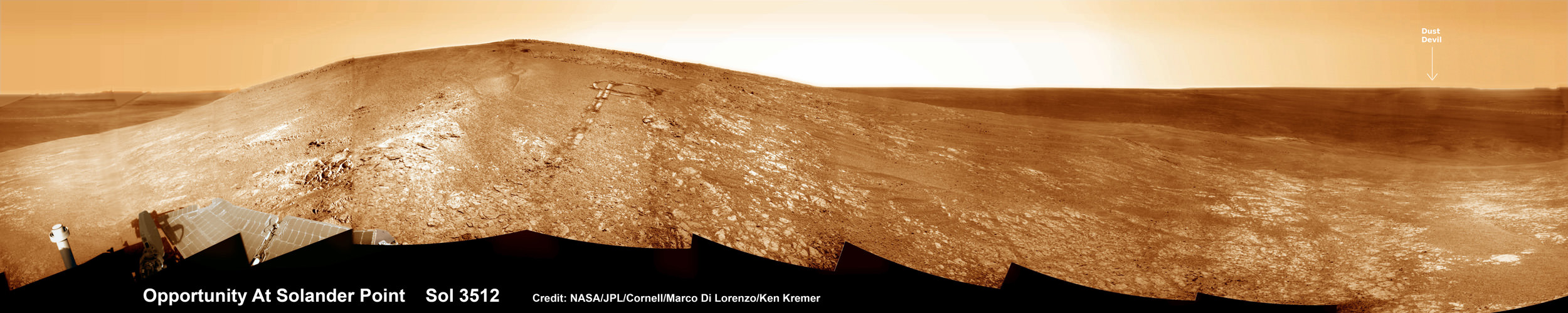
NASA’s Opportunity rover captured this panoramic mosaic on Dec. 10, 2013 (Sol 3512) near the summit of “Solander Point” on the western rim of Endeavour Crater where she starts Decade 2 on the Red Planet. She is currently investigating outcrops of potential clay minerals formed in liquid water on her 1st mountain climbing adventure. Assembled from Sol 3512 navcam raw images. Credit: NASA/JPL/Cornell/Marco Di Lorenzo/Ken Kremer-kenkremer.com
‘Pinnacle Island’ had suddenly appeared out of nowhere in a set of before/after pictures taken by Opportunity’s cameras on Jan, 8, 2014 (Sol 3540), whereas that exact same spot had been vacant of debris in photos taken barely 4 days earlier. And the rover hadn’t budged a single millimeter.
So the HiRISE research team was called in to plan a new high resolution observation of the ‘Murray Ridge’ area and gather clues about the rocky riddle.
The purpose was to “check the remote possibility that a fresh impact by an object from space might have excavated a crater near Opportunity and thrown this rock to its new location”- now known as Pinnacle Island, said NASA in a statement.
Well, no fresh crater impacting site was found in the new image.
“We see no obvious signs of a very recent crater in our image, but a careful comparison to prior images might reveal subtle changes,” wrote HiRISE principal investigator Alfred McEwen in a description today.
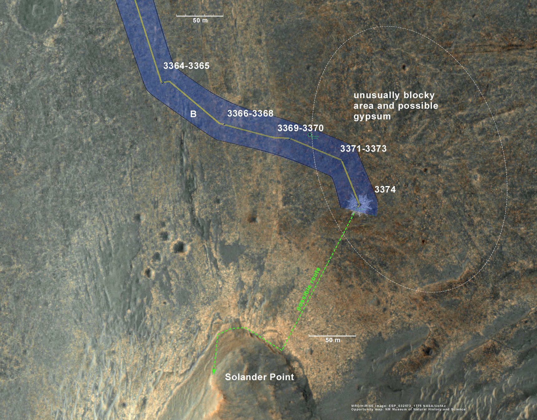
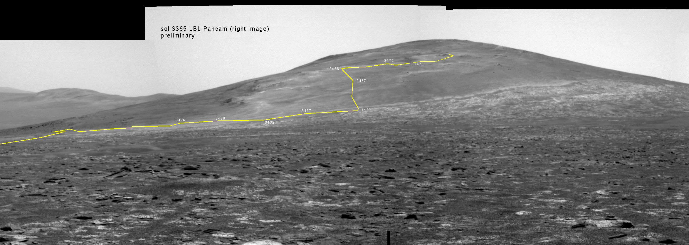
Back on sol 3365 we took this image of Solander Point as we approached it. Here I have plotted the subsequent route that Opportunity has taken in climbing up the ridge. The outcrop shown I the images below are near the end of the yellow traverse line. Caption and mosaic by Larry Crumpler/NASA/JPL/
In the meantime, as I reported here a few days ago the mystery was solved at last by the rover team after Opportunity drove a short distance away from the ‘jelly doughnut’ rock and snapped some ‘look back’ photographs to document the ‘mysterious scene’ for further scrutiny.
It turns out that the six wheeled Opportunity unknowingly ‘created’ the mystery herself when she drove over a larger rock, crushing and breaking it apart with the force from the wheels and her hefty 400 pound (185 kg) mass.
“Once we moved Opportunity a short distance, after inspecting Pinnacle Island, we could see directly uphill an overturned rock that has the same unusual appearance,” said Opportunity Deputy Principal Investigator Ray Arvidson of Washington University in St. Louis, in a NASA statement.
“Murray Ridge” and the Solander Point mountaintop are of great scientific interest because the region is riven with outcrops of minerals, including clay minerals, that likely formed in flowing liquid neutral water conducive to life – potentially a scientific goldmine.
Today, Feb 19, marks Opportunity’s 3582nd Sol or Martian Day roving Mars. She is healthy with plenty of power.
So far she has snapped over 188,800 amazing images on the first overland expedition across the Red Planet.
Her total odometry stands at over 24.07 miles (38.73 kilometers) since touchdown on Jan. 24, 2004 at Meridiani Planum.
Opportunity by Solander Point peak – 2nd Mars Decade Starts here!
NASA’s Opportunity rover captured this panoramic mosaic on Dec. 10, 2013 (Sol 3512) near the summit of “Solander Point” on the western rim of vast Endeavour Crater where she starts Decade 2 on the Red Planet. She is currently investigating summit outcrops of potential clay minerals formed in liquid water on her 1st mountain climbing adventure. See wheel tracks at center and dust devil at right. Assembled from Sol 3512 navcam raw images. Credit: NASA/JPL/Cornell/Marco Di Lorenzo/Ken Kremer-kenkremer.com
Meanwhile on the opposite side of Mars, Opportunity’s younger sister rover Curiosity is trekking towards gigantic Mount Sharp and just crested over the Dingo Gap sand dune. She celebrated 500 Sols on Mars on New Years Day 2014.
Finally, China’s Yutu rover has awoken for her 3rd workday on the Moon.
Stay tuned here for Ken’s continuing Opportunity, Curiosity, Chang’e-3, LADEE, MAVEN, Mars rover, MOM and continuing planetary and human spaceflight news.
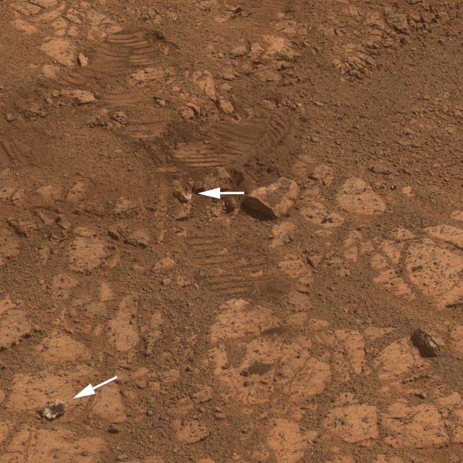
This image from the panoramic camera (Pancam) on NASA’s rover Opportunity shows the location of a rock called “Pinnacle Island” before it appeared in front of the rover in early January 2014. Arrow at lower left. This image was taken during Sol 3567 of Opportunity’s work on Mars (Feb. 4, 2014). Credit: NASA/JPL-Caltech/Cornell Univ./Arizona State Univ.Traverse Map for NASA’s Opportunity rover from 2004 to 2014
This map shows the entire path the rover has driven during a decade on Mars and over 3560 Sols, or Martian days, since landing inside Eagle Crater on Jan 24, 2004 to current location by Solander Point summit at the western rim of Endeavour Crater. Rover will spend 6th winter here atop Solander. Opportunity discovered clay minerals at Esperance – indicative of a habitable zone. Credit: NASA/JPL/Cornell/ASU/Marco Di Lorenzo/Ken Kremer – kenkremer.comNASA’s Opportunity rover was imaged here from Mars orbit by MRO HiRISE camera on Feb. 14, 2014. This mosaic shows Opportunity’s view today while looking back to vast Endeavour crater from atop Murray Ridge by summit of Solander Point. Opportunity captured this photomosaic view on Feb. 16, 2014 (Sol 3579) from the western rim of Endeavour Crater where she is investigating outcrops of potential clay minerals formed in liquid water. Assembled from Sol 3579 navcam raw images. Credit: NASA/JPL/Cornell/Marco Di Lorenzo/Ken Kremer-kenkremer.com
Carbonate-Containing Martian Rocks discovered by Spirit Mars Rover. Spirit collected data in late 2005 which confirmed that the Comanche outcrop contains magnesium iron carbonate, a mineral indicating the past environment was wet and non-acidic, possibly favorable to life. This view was captured during Sol 689 on Mars (Dec. 11, 2005). The find at Comanche is the first unambiguous evidence from either Spirit or Opportunity for a past Martian environment that may have been more favorable to life than the wet but acidic conditions indicated by the rovers' earlier finds. Credit: NASA/JPL-Caltech/Cornell University
A Top 10 Decade 1 Discovery by NASA’s Twin Mars Exploration Rovers
Carbonate-Containing Martian Rocks discovered by Spirit Mars Rover
Spirit collected data in late 2005 which confirmed that the Comanche outcrop contains magnesium iron carbonate, a mineral indicating the past environment was wet and non-acidic, possibly favorable to life. This view was captured during Sol 689 on Mars (Dec. 11, 2005). The find at Comanche is the first unambiguous evidence from either Spirit or Opportunity for a past Martian environment that may have been more favorable to life than the wet but acidic conditions indicated by the rovers’ earlier finds. Credit: NASA/JPL-Caltech/Cornell University Story updated[/caption]
January 2014 marks the 10th anniversary since the nail biting and history making safe landings of NASA’s renowned Mars Explorations Rovers – Spirit and Opportunity – on the Red Planet barely three weeks apart during January 2004.
Due to their completely unforeseen longevity, a decade of spectacular and groundbreaking scientific discoveries continuously flowed from the robot sisters that have graced many articles, magazine covers, books, documentaries and refereed scientific papers.
What are the Top 10 Decade 1 discoveries from Spirit and Opportunity?
Find out below what a top Mars rover team scientist told Universe Today!
Ray Arvidson, the rovers Deputy Principal Investigator and professor at Washington University in St. Louis, has kindly shared with me his personal list of the Top 10 discoveries from Spirit and Opportunity for the benefit of readers of Universe Today.
The Top 10 list below are Ray’s personal choices and does not necessarily reflect the consensus of the Mars Explorations Rover (MER) team.
First some background.
The dynamic duo were launched on their interplanetary voyages from Cape Canaveral Florida atop Delta II rockets during the summer of 2003.
The now legendary pair landed on opposite sides of the Red Planet. Spirit landed first on Jan. 3 inside Gusev Crater and twin sister Opportunity landed second on Jan. 24 on the dusty plains of Meridiani Planum.
A Moment Frozen in Time
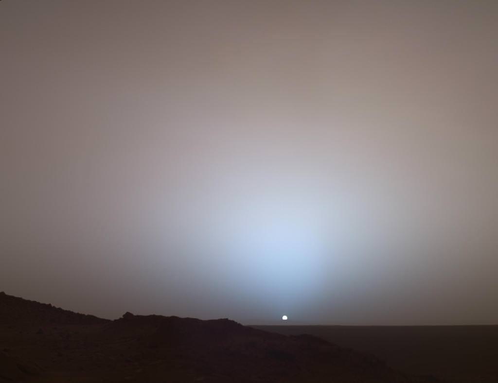
On May 19th, 2005, NASA’s Mars Exploration Rover Spirit captured this stunning view as the Sun sank below the rim of Gusev crater on Mars. This Panoramic Camera (Pancam) mosaic was taken around 6:07 in the evening of Sol 489. The terrain in the foreground is the rock outcrop “Jibsheet,” a feature that Spirit has been investigating for several weeks (rover tracks are dimly visible leading up to “Jibsheet”). The floor of Gusev crater is visible in the distance, and the Sun is setting behind the wall of Gusev some 80 km (50 miles) in the distance. Credit: NASA/JPL-Caltech/Texas A&M/Cornell
The goal was to “follow the water” as a potential enabler for past Martian microbes if they ever existed.
Together, the long-lived, golf cart sized robots proved that early Mars was warm and wet, billions of years ago – a key finding in the search for habitats conducive to life beyond Earth.
The solar powered robo duo were expected to last a mere three months – with a ‘warrenty’ of 90 Martian days (Sols).
Spirit endured the utterly extreme Red Planet climate for more than six years until communications ceased in 2010.
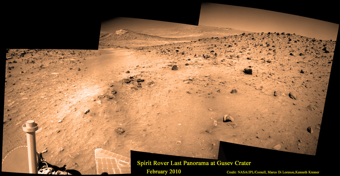
Last View from Spirit rover on Mars
Spirit’s last panorama from Gusev Crater was taken during February 2010 before her death from extremely low temperatures during her 4th Martian winter. Spirit was just 500 feet from her next science target – dubbed Von Braun – at center, with Columbia Hills as backdrop. Mosaic Credit: Marco Di Lorenzo/ Kenneth Kremer/ NASA/JPL/Cornell University.
Mosaic featured on Astronomy Picture of the Day (APOD) on 30 May 2011 – http://apod.nasa.gov/apod/ap110530.html
Opportunity lives on TODAY and is currently exploring by the summit of Solander Point on the western rim of a vast crater named Endeavour that spans some 22 kilometers (14 miles) in diameter.
“Because of the rovers’ longevity, we essentially got four different landing sites for the price of two,” says the rovers’ Principal Investigator, Steve Squyres of Cornell University, Ithaca, N.Y.
Here are the Top 10 MER discoveries from Ray Arvidson, Deputy Principal Investigator
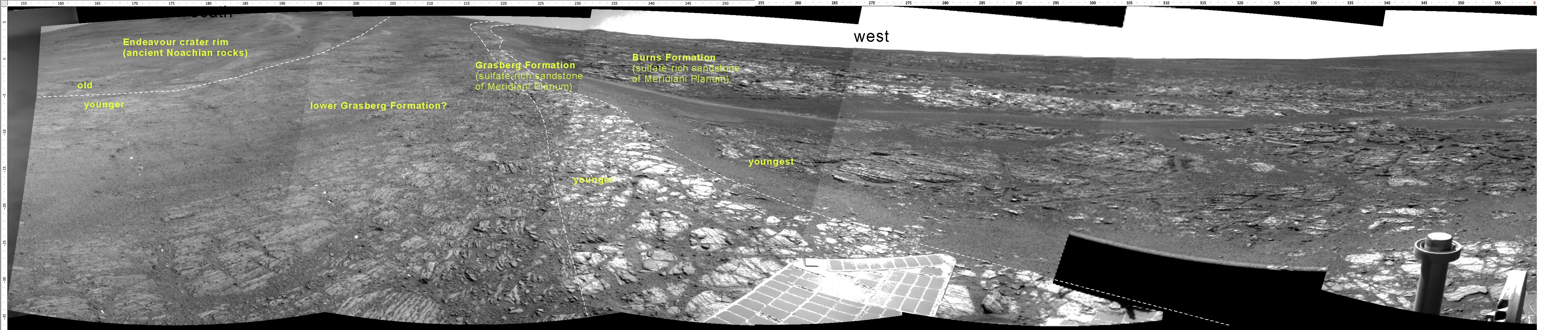
1. Opportunity: Ancient Acidic Martian Lakes
The Meridiani plains Burns formation as sulfate-rich sandstones with hematitic concretions formed in ancient acidic and oxidizing shallow lakes and reworked into sand dunes and cemented by rising groundwaters.
‘Burns Cliff’ Color Panorama Opportunity captured this view of “Burns Cliff” after driving right to the base of this southeastern portion of the inner wall of “Endurance Crater.” The view combines frames taken by Opportunity’s panoramic camera between the rover’s 287th and 294th martian days (Nov. 13 to 20, 2004). The mosaic spans more than 180 degrees side to side. Credit: NASA/JPL-Caltech/Cornell
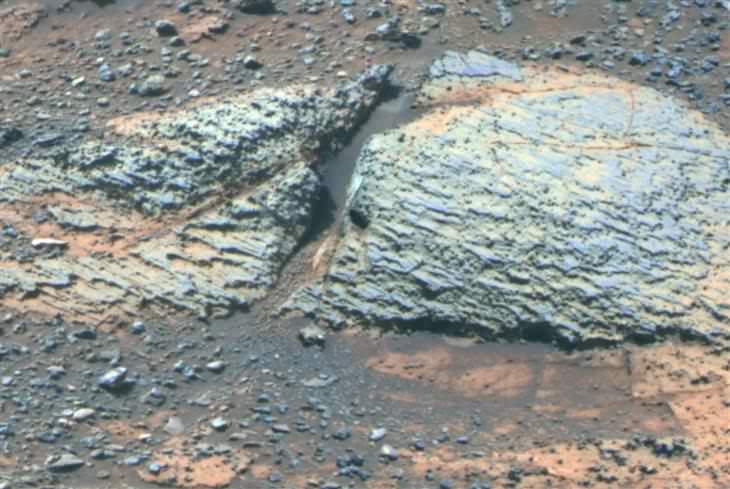
2. Opportunity: Phyllosilicate Clays at ‘Whitewater Lake’ at Endeavour Crater indicate Ancient Habitable Zone
At the rim of Endeavour crater and the Cape York rim segment the discovery of ferric and aluminous smectite [phyllosilicate] clays in the finely-layered Matijevic formation rocks that pre-exist the Endeavour impact event.
Pancam false-color view acquired on Sol 3066 (Sept. 8 2012) of fine-scale layering in the Whitewater Lake locality that is indicative of an ancient aqueous environment on Mars. Veneers have been resistant to wind erosion and enhanced the layered appearance of the outcrop. Layers are typically several millimeters thick. Credit: NASA/JPL-Caltech/Cornell/Arizona State University
Alteration in moderately acidic and reducing waters, perhaps mildly oxidizing for ferric smectites. These are the oldest rocks examined by Opportunity and the waters are much more habitable than waters that led to Burns formation.
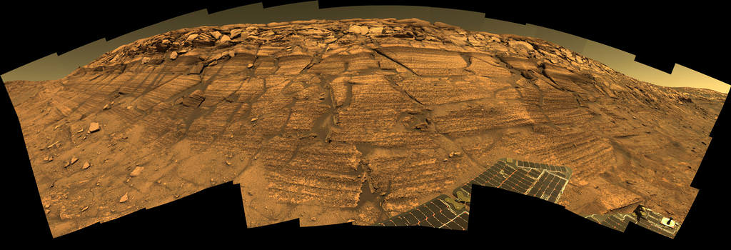
Opportunity rover discovered phyllosilicate clay minerals and calcium sulfate veins at the bright outcrops of ‘Whitewater Lake’, at right, imaged by the Navcam camera on Sol 3197 (Jan. 20, 2013, coinciding with her 9th anniversary on Mars. “Copper Cliff” is the dark outcrop, at top center. Darker “Kirkwood” outcrop, at left, is site of mysterious “newberries” concretions. This panoramic view was snapped from ‘Matijevic Hill’ on Cape York ridge at Endeavour Crater. Credit: NASA/JPL-Caltech/Cornell/Marco Di Lorenzo/Ken Kremer
3. Opportunity: Martian Meteorites
Many meteorites were found [throughout the long traverse] that are dispersed across the Meridiani plains landing site
4. Opportunity: Wind-blown sand ripples
Wind-blown sand ripples throughout the Meridiani plains relict from the previous wind regime, probably when Mars spin axis tilt was different than today’s value
5. Spirit: Opaline silica indicates Ancient Hydrothermal system
Discovery of Opaline silica at Home Plate, Gusev Crater. This formed in volcanic fumeroles and/or hydrothermal vents indicating that water was interacting with magma.
Spirit acquired this mosaic on Sol 1202 (May 21, 2007), while investigating the area east of the elevated plateau known as “Home Plate” in the “Columbia Hills.” The mosaic shows an area of disturbed soil, nicknamed “Gertrude Weise” by scientists, made by Spirit’s stuck right front wheel. The trench exposed a patch of nearly pure silica, with the composition of opal. It could have come from either a hot-spring environment or an environment called a fumarole, in which acidic, volcanic steam rises through cracks. Either way, its formation involved water, and on Earth, both of these types of settings teem with microbial life. Credit: NASA/JPL-Caltech/Cornell
6. Spirit: Carbonates at Comanche – see lead image above
The discovery of Fe-Mg [iron-magnesium] carbonates at the Comanche outcrop on Husband Hill, Gusev Crater, again showing that water interacted with magma.
Note: Carbonates form in neutral, non-acid water. This was the first time they were found and investigated examined on the surface Mars during Dec. 2005.
7. Spirit: Ferric sulfates moved by modern water
Ferric sulfates moved down the soil column by modern waters at Troy and Husband Hill in Gusev Crater.
‘Calypso’ Panorama of Spirit’s View from ‘Troy’. This full-circle view from the panoramic camera (Pancam) on NASA’s Mars Exploration Rover Spirit shows the terrain surrounding the location called “Troy,” where Spirit became embedded in soft soil during the spring of 2009. The hundreds of images combined into this view were taken beginning on the 1,906th Martian day (or sol) of Spirit’s mission on Mars (May 14, 2009) and ending on Sol 1943 (June 20, 2009). Credit: NASA/JPL-Caltech/Cornell University
8. Spirit: Modern water alters rocks
Complex coatings on olivine basalts on the Gusev Crater plains showing modern water or frost has altered rock surfaces
9. Both rovers: Martian Dust Devils
The finding [and imaging] of dust devil frequency and dynamics, showing how dust and sand are moved by wind in the very thin Martian atmosphere.
Note: Wind action occasionally cleaning off the solar panels led to their unexpected longevity
See a dust devil imaged in our Solander Point mosaic below
Spirit Mars rover – view from Husband Hill summit – panels cleaned by wind action
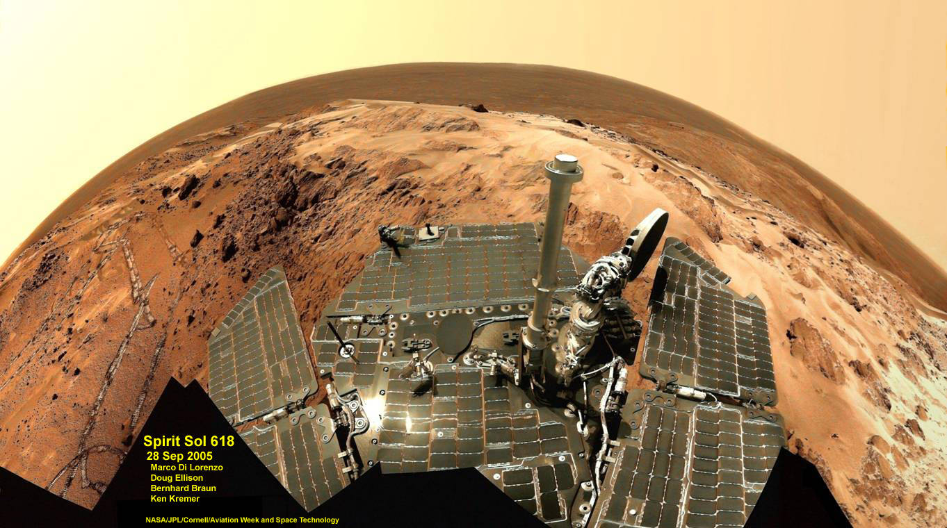
Spirit snapped this unique self portrait view from the summit of Husband Hill inside Gusev crater on Sol 618 on 28 September 2005. The rovers were never designed or intended to climb mountains. It took more than 1 year for Spirit to scale the Martian mountain. This image was created from numerous raw images by an international team of astronomy enthusiasts and appeared on the cover of the 14 November 2005 issue of Aviation Week & Space Technology magazine and the April 2006 issue of Spaceflight magazine. Also selected by Astronomy Picture of the Day (APOD) on 28 November 2005. Credit: NASA/JPL/Cornell/ Marco Di Lorenzo/Doug Ellison/Bernhard Braun/Ken Kremer – kenkremer.com
10. Both rovers: Atmospheric Argon measurements
Argon gas was used as a tracer of atmospheric dynamics by both rovers. It was measured by using the APXS (Alpha Particle X-Ray Spectrometer) on the robotic arm to measure the Martian atmosphere and detect argon
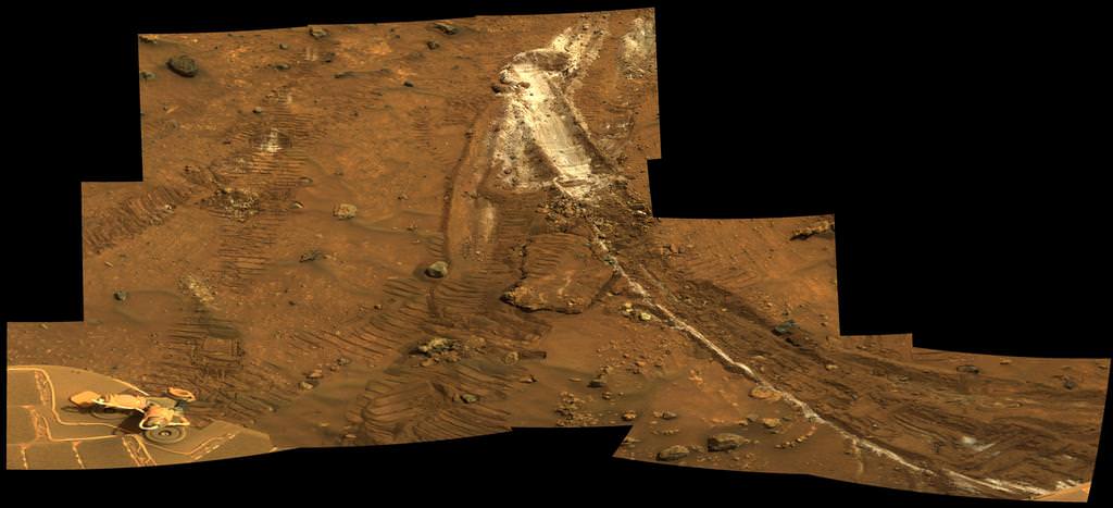
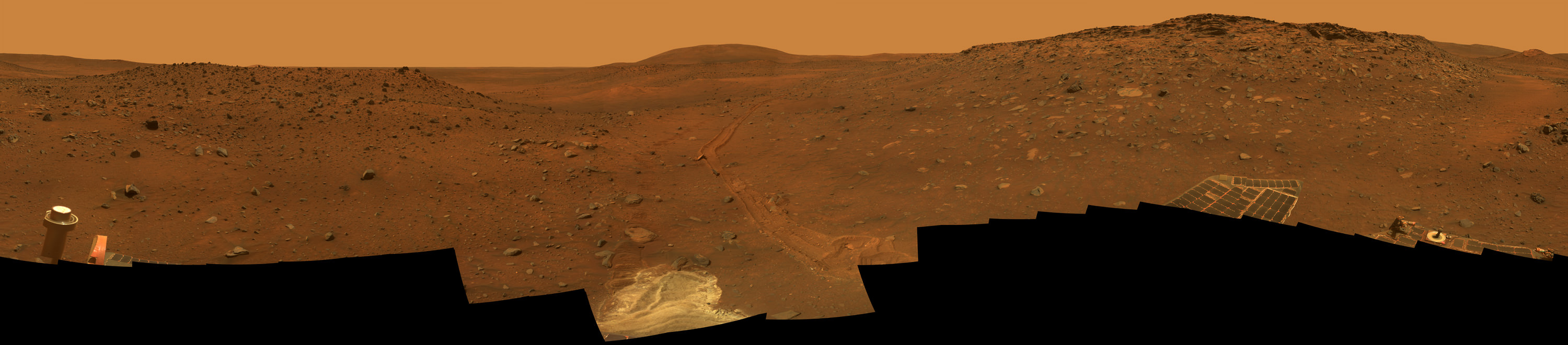
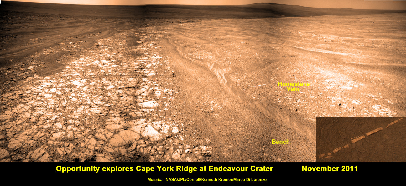
Another major discovery by Opportunity was the finding of hydrated mineral veins of calcium sulfate in the bench surrounding Cape York. The vein discovery is another indication of the ancient flow of liquid water in this region on Mars.
Opportunity discovers hydrated Mineral Vein at Endeavour Crater – November 2011. Opportunity determined that the ‘Homestake’ mineral vein was composed of calcium sulfate,or gypsum, while exploring around the base of Cape York ridge at the western rim of Endeavour Crater. The vein discovery indicates the ancient flow of liquid water at this spot on Mars. This panoramic mosaic of images was taken on Sol 2761, November 2011, and illustrates the exact spot of the mineral vein discovery. Featured on NASA Astronomy Picture of the Day (APOD) on 12 Dec 2011 – http://apod.nasa.gov/apod/ap111212.html. Credit: NASA/JPL/Cornell/Kenneth Kremer/Marco Di Lorenzo.
Altogether, Spirit snapped over 128,000 raw images, drove 4.8 miles (7.7 kilometers) and ground into 15 rock targets.
Opportunity is currently investigating a new cache of exposed clay mineral outcrops by the summit of Solander Point, a rim segment just south of Cape York and Matejivic Hill.
These new outcrops at ‘Cape Darby’ like those at ‘Esperance’ at Matijevic Hill were detected based on spectral observations by the CRISM spectrometer aboard NASA’s Mars Reconnaissance Orbiter (MRO) circling overhead, Arvidson told me.
Opportunity by Solander Point peak – 2nd Mars Decade Starts here!
NASA’s Opportunity rover captured this panoramic mosaic on Dec. 10, 2013 (Sol 3512) near the summit of “Solander Point” on the western rim of vast Endeavour Crater where she starts Decade 2 on the Red Planet. She is currently investigating summit outcrops of potential clay minerals formed in liquid water on her 1st mountain climbing adventure. See wheel tracks at center and dust devil at right. Assembled from Sol 3512 navcam raw images. Credit: NASA/JPL/Cornell/Marco Di Lorenzo/Ken Kremer-kenkremer.com
Today, Jan. 31, marks Opportunity’s 3563rd Sol or Martian Day roving Mars – for what was expected to be only a 90 Sol mission.
So far she has snapped over 188,200 amazing images on the first overland expedition across the Red Planet.
Her total odometry stands at over 24.07 miles (38.73 kilometers) since touchdown on Jan. 24, 2004 at Meridiani Planum.
Meanwhile on the opposite side of Mars, Opportunity’s younger sister rover Curiosity is trekking towards gigantic Mount Sharp. She celebrated 500 Sols on Mars on New Years Day 2014.
What’s Ahead for Opportunity in Decade 2 on Mars ?
Many more ground breaking discoveries surely lie ahead for Opportunity since she is currently exploring ancient terrain at Endeavour crater that’s chock full of minerals indicative of a Martian habitable zone.
She remains healthy and the solar panels are generating enough power to actively continue science investigations throughout her 6th frigid Martian winter!
NASA’s Opportunity Mars rover recorded the component images for this self-portrait near the peak of Solander Point and about three weeks before completing a decade of work on Mars. The rover’s panoramic camera (Pancam) took the images during the interval Jan. 3, 2014, to Jan. 6, 2014. Credit: NASA/JPL-Caltech/Cornell/Arizona State University
Therefore – Stay tuned here for Ken’s continuing Opportunity, Curiosity, Chang’e-3, LADEE, MAVEN, Mars rover and MOM news.
Spirit Rover traverse map from Gusev Crater landing site to Home Plate: 2004 to 2011Traverse Map for NASA’s Opportunity rover from 2004 to 2014
This map shows the entire path the rover has driven during a decade on Mars and over 3560 Sols, or Martian days, since landing inside Eagle Crater on Jan 24, 2004 to current location by Solander Point summit at the western rim of Endeavour Crater. Rover will spend 6th winter here atop Solander. Opportunity discovered clay minerals at Esperance – indicative of a habitable zone. Credit: NASA/JPL/Cornell/ASU/Marco Di Lorenzo/Ken Kremer – kenkremer.com
Opportunity starts Martian Mountaineering. NASA’s Opportunity rover captured this southward uphill panoramic mosaic on Oct. 21, 2013 (Sol 3463) after beginning to ascend the northwestern slope of "Solander Point" on the western rim of Endeavour Crater - her 1st mountain climbing adventure. The northward-facing slope will tilt the rover's solar panels toward the sun in the southern-hemisphere winter sky, providing an important energy advantage for continuing mobile operations through the upcoming winter. Assembled from Sol 3463 navcam raw images by Marco Di Lorenzo and Ken Kremer. Credit: NASA/JPL/Cornell/Marco Di Lorenzo/Ken Kremer
Opportunity starts Martian Mountaineering
NASA’s Opportunity rover captured this southward uphill panoramic mosaic on Oct. 21, 2013 (Sol 3463) after beginning to ascend the northwestern slope of “Solander Point” on the western rim of Endeavour Crater – her 1st mountain climbing adventure. The northward-facing slope will tilt the rover’s solar panels toward the sun in the southern-hemisphere winter sky, providing an important energy advantage for continuing mobile operations through the upcoming winter. Assembled from Sol 3463 navcam raw images by Marco Di Lorenzo and Ken Kremer.
Credit: NASA/JPL/Cornell/Marco Di Lorenzo/Ken Kremer Story and imagery updated[/caption]
“This is our first real Martian mountaineering with Opportunity,” said the principal investigator for the rover, Steve Squyres of Cornell University, Ithaca, N.Y.
And it happened right in the middle of the utterly chaotic US government shutdown ! – that seriously harmed some US science endeavors. And at a spot destined to become a science bonanza in the months and years ahead – so long as she stays alive to explore ever more new frontiers.
On Oct. 8, mission controllers on Earth directed the nearly decade old robot to start the ascent of Solander Point – the northern tip of the tallest hill she has encountered after nearly 10 Earth years on Mars.
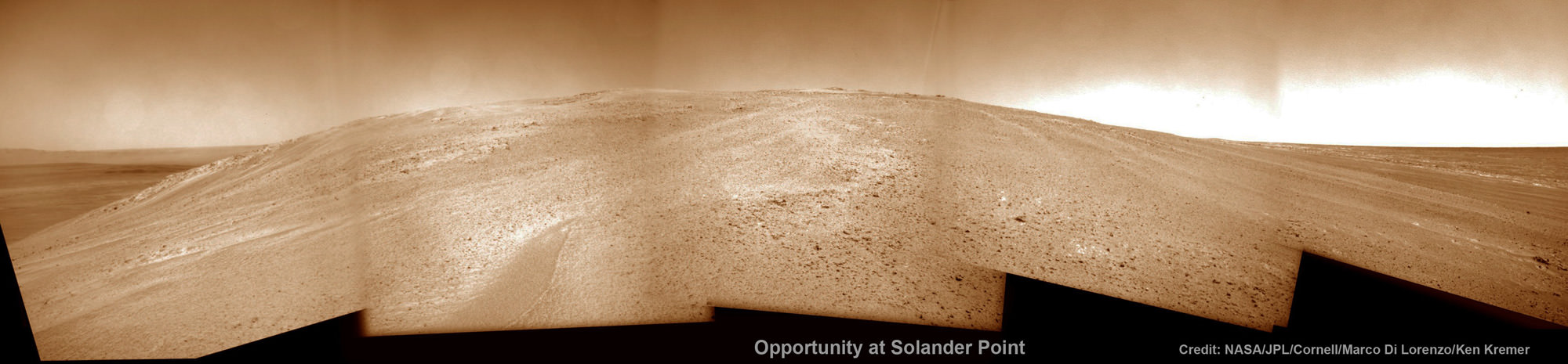
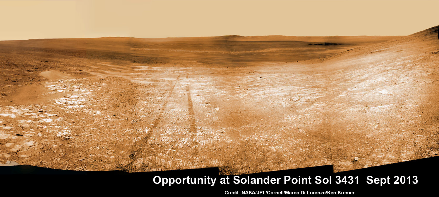
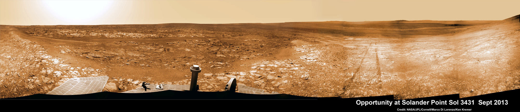
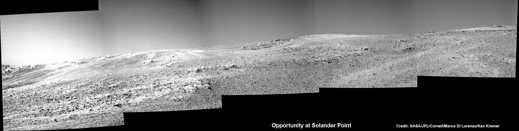
Opportunity starts scaling Solander Point – her1st mountain climbing goal. See the tilted terrain and rover tracks in this mosaic view from Solander Point peering across the vast expanse of huge Endeavour Crater. Opportunity will ascend the mountain looking for clues indicative of a Martian habitable environment. This navcam camera mosaic was assembled from raw images taken on Sol 3431 (Sept.18, 2013). Credit: NASA/JPL/Cornell/Marco Di Lorenzo/Ken Kremer (kenkremer.com). See the complete panoramic view below
The northward-facing slopes at Solander also afford another major advantage. They will tilt the rover’s solar panels toward the sun in the southern-hemisphere winter sky, providing an important energy boost enabling continued mobile operations through the upcoming frigidly harsh winter- her 6th since landing in 2004.
Opportunity will first explore outcrops on the northwestern slopes of Solander Point in search of the chemical ingredients required to sustain life before gradually climbing further uphill to investigate intriguing deposits distributed amongst its stratographic layers.
The rover will initially focus on outcrops located in the lower 20 feet (6 meters) above the surrounding plains on slopes as steep as 15 to 20 degrees.
Opportunity starts scaling Solander Point – her 1st mountain climbing goal. See the tilted terrain and rover tracks in this panoramic view from Solander Point peering across the vast expanse of huge Endeavour Crater. Opportunity will ascend the mountain looking for clues indicative of a Martian habitable environment. This navcam camera mosaic was assembled from raw images taken on Sol 3431 (Sept.18, 2013). Credit: NASA/JPL/Cornell/Marco Di Lorenzo/Ken Kremer (kenkremer.com).
At some later time, Opportunity may ascend Solander farther upward, which peaks about 130 feet (40 meters) above the crater plains.
“We expect we will reach some of the oldest rocks we have seen with this rover — a glimpse back into the ancient past of Mars,” says Squyres.
NASA’s powerful Mars Reconnaissance Orbiter (MRO) circling overhead recently succeeded in identifying clay-bearing rocks during new high resolution survey scans of Solander Point!
As I reported previously, the specially collected high resolution observations by the orbiters Compact Reconnaissance Imaging Spectrometer for Mars (CRISM) were collected in August and being analyzed by the science team. They will be used to direct Opportunity to the most productive targets of interest
“CRISM data were collected,” Ray Arvidson told Universe Today. Arvidson is the mission’s deputy principal scientific investigator from Washington University in St. Louis, Mo.
“They show really interesting spectral features in the [Solander Point] rim materials.”
NASA’s Opportunity rover captured this southward uphill view on Oct. 21, 2013 after beginning to ascend the northwestern slope of “Solander Point” on the western rim of Endeavour Crater. The northward-facing slope will tilt the rover’s solar panels toward the sun in the southern-hemisphere winter sky, providing an important energy advantage for continuing mobile operations through the upcoming winter. Credit: NASA/JPL
The new CRISM survey from Mars orbit yielded mineral maps which vastly improves the spectral resolution – from 18 meters per pixel down to 5 meters per pixel.
This past spring and summer, Opportunity drove several months from the Cape York rim segment to Solander Point.
“At Cape York, we found fantastic things,” Squyres said. “Gypsum veins, clay-rich terrain, the spherules we call newberries. We know there are even larger exposures of clay-rich materials where we’re headed. They might look like what we found at Cape York or they might be completely different.”
The summit of Solander Point
Opportunity rover captured mosaic on Oct. 21, 2013 (Sol 3463) after beginning to ascend the northwestern slope of “Solander Point” on the western rim of Endeavour Crater – her 1st mountain climbing adventure. Assembled from Sol 3463 pancam high resolution raw images by Marco Di Lorenzo and Ken Kremer. Credit: NASA/JPL/Cornell/Marco Di Lorenzo/Ken Kremer
Clay minerals, or phyllosilicates, form in neutral water that is more conducive to life.
At the base of Solander, the six wheeled rover discovered a transition zone between a sulfate-rich geological formation and an older formation. Sulfate-rich rocks form in a wet environment that was very acidic and less favorable to life.
Solander Point is located at the western rim of the vast expanse of Endeavour crater – some 22 kilometers (14 miles) in diameter.
Today marks Opportunity’s 3466th Sol or Martian Day roving Mars – for what was expected to be only a 90 Sol mission.
So far she has snapped over 185,200 amazing images on the first overland expedition across the Red Planet.
Her total odometry stands at over 23.89 miles (38.45 kilometers) since touchdown on Jan. 24, 2004 at Meridiani Planum.
On the opposite side of Mars, Opportunity’s younger sister rover Curiosity is trekking towards gigantic Mount Sharp and recently discovered a patch of pebbles formed by flowing liquid water.
Traverse Map for NASA’s Opportunity rover from 2004 to 2013
This map shows the entire path the rover has driven during nearly 10 years and over 3460 Sols, or Martian days, since landing inside Eagle Crater on Jan 24, 2004 to current location ascending her 1st Martian Mountain – Solander Point – at the western rim of Endeavour Crater. Opportunity discovered clay minerals at Esperance – indicative of a habitable zone and seeks clay minerals now at Solander. Credit: NASA/JPL/Cornell/ASU/Marco Di Lorenzo/Ken Kremer
Opportunity starts scaling Solander Point See the tilted terrain and rover tracks in this look-back mosaic view from Solander Point peering across the vast expanse of huge Endeavour Crater. Moasic assembled from navcam raw images taken on Sol 3431 (Sept.18, 2013). Credit: NASA/JPL/Cornell/Marco Di Lorenzo/Ken Kremer - kenkremer.com
Opportunity starts scaling Solander Point – her 1st mountain climbing goal
See the tilted terrain and rover tracks in this look-back mosaic view from Solander Point peering across the vast expanse of huge Endeavour Crater. Opportunity will ascend the mountain looking for clues indicative of a Martian habitable environment. This navcam camera mosaic was assembled from raw images taken on Sol 3431 (Sept.18, 2013). Credit: NASA/JPL/Cornell/Marco Di Lorenzo/Ken Kremer (kenkremer.com). See the complete panoramic view below[/caption]
NASA’s intrepid Opportunity rover has begun an exciting new phase in her epic journey – the ascent of Solander Point, the first mountain she will ever climb, after roving the Red Planet for nearly a decade. See the rovers tilted look-back view in our Sol 3431 mosaic above.
Furthermore, ground breaking discoveries providing new clues in search of the chemical ingredients required to sustain life are sure to follow as the rover investigates intriguing stratographic deposits distributed amongst Solander’s hills layers.
Why ? Because NASA’s powerful Mars Reconnaissance Orbiter (MRO) circling overhead has also recently succeeded in collecting “really interesting” new high resolution survey scans of Solander Point! Read my prior pre-survey account – here.
So says Ray Arvidson, the mission’s deputy principal scientific investigator, in an exclusive Opportunity news update to Universe Today. The new MRO data are crucial for targeting the rover’s driving in coming months.
After gaining approval from NASA, engineers successfully aimed the CRISM mineral mapping spectrometer aboard MRO at Solander Point and captured reams of new high resolution measurements that will inform the scientists about the mineralogical make up of Solander.
“CRISM data were collected,” Arvidson told Universe Today.
“They show really interesting spectral features in the [Endeavour Crater] rim materials.”
Opportunity starts scaling Solander Point – her 1st mountain climbing goal
See the tilted terrain and rover tracks in this look-back panoramic view from Solander Point peering across the vast expanse of huge Endeavour Crater. Opportunity will ascend the mountain looking for clues indicative of a Martian habitable environment. This navcam camera mosaic was assembled from raw images taken on Sol 3431 (Sept.18, 2013). Credit: NASA/JPL/Cornell/Marco Di Lorenzo/Ken Kremer (kenkremer.com).
Solander Point is an eroded ridge located along the western rim of huge Endeavour Crater where Opportunity is currently located.
“Opportunity is on the bench at the tip of Solander Point,” Ray Arvidson told Universe Today exclusively. Arvidson is the mission’s deputy principal scientific investigator from Washington University in St. Louis, Mo.
At the bench, the long lived rover has begun scaling Solander in search of science and life giving sun.
“The CRISM data are being discussed by the MER [Mars Exploration Rover] Team this week,” Arvidson told me.
And it will take some time to review and interpret the bountiful new spectral data and decide on a course of action.
“For the CRISM data analysis we will have the MER Team see the results and agree.”
Expect that analysis to take a “couple of weeks” said Arvidson.
The new CRISM survey from Mars orbit will vastly improve the spectral resolution – from 18 meters per pixel down to 5 meters per pixel.
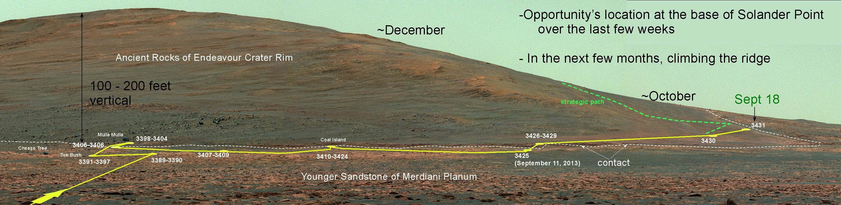
Above is the Pancam panorama acquired on sol 3375 when Opportunity was still approaching Solander Point. On it I have plotted the subsequent drives along the east side of the point, and the location on the contact as of September 18. The approximate places where we need to be by later this fall are shown here for anyone following along. It’s a new unexplored land with new scenes. Caption and Credit: NASA/JPL/Larry Crumpler
Another important point about ‘Solander Point’ is that it also offers northerly tilted slopes that will maximize the power generation during Opportunity’s upcoming 6th Martian winter.
In order to survive those Antarctic like, ‘bone chilling” winter temperatures on the Red Planet and continue with her epic mission, the engineers must drive the rover so that the solar wings are pointed favorably towards the sun.
And don’t forget that winter’s last six full months – that’s twice as long on Mars as compared to Earth.
The daily solar power output has been declining as Mars southern hemisphere enters late fall.
In the above Navcam panorama acquired on mid-morning on September 18 (sol 3431), you can see the contact between the younger Burns Formation sulfate-rich sands on the right and the older rocks of Endeavour crater on the left. We will probably follow this contact for ways to the south before starting the climb next week. Caption and Credit: NASA/JPL/Larry Crumpler
After traversing several months across the crater floor from the Cape York rim segment to Solander, Opportunity arrived at the foothills of Solander Point.
Solander and Cape York are part of a long chain of eroded segments of the crater wall of Endeavour crater which spans a humongous 14 miles (22 kilometers) wide.
Solander Point may harbor deposits of phyllosilicate clay minerals – which form in neutral pH water – in a thick layer of rock stacks indicative of a past Martian habitable zone.
The science team is looking at the new CRISM measurements, hunting for signatures of phyllosilicate clay minerals and other minerals and features of interest.
“Opportunity is on the bench on the northwest side of the tip of Solander Point,” Arvidson explained.
Since pulling up to Solander, the robot has spent over a month investigating the bench surrounding the mountain to put it the entire alien Martian terrain in context for a better understanding of Mars geologic history over billions of years.
Eons ago, Mars was far warmer and wetter and more hospitable to life.
“The rover is finishing up work on defining the stratigraphy, structure, and composition of the bench materials.”
“We are working our way counterclockwise on the bench to reach the steep slopes associated with the Noachian outcrops that are part of the Endeavour rim,” Arvidson elaborated.
“Opportunity is slightly tipped to the north to catch the sun.”
“Probably this week we will direct the rover to head south along the western boundary between the bench and the rim materials, keeping on northerly tilts,” Arvidson told me.
How does the bench at Solander compare to other areas investigated at Endeavour crater, I asked.
“The Solander Bench looks like the bench we saw around Cape York and around Sutherland Point and Nobbys Head,” replied Arvidson.
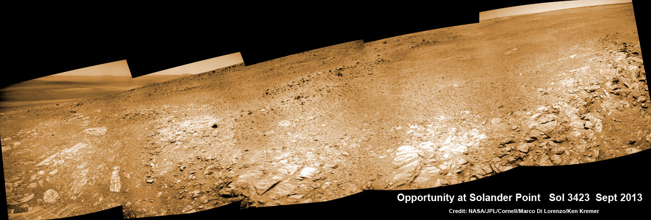
Opportunity scans Solander Point from a slope at the northern tip as she circles around the surrounding bench. This navcam camera mosaic was assembled from raw images taken on Sol 3423 (Sept. 2013). Credit: NASA/JPL/Cornell/Marco Di Lorenzo/Ken Kremer
The rover recently investigated an outcrop target called ‘Poverty Bush’. She deployed her 3 foot long (1 meter) robotic arm and collected photos with the Microscopic Imager (MI) and collected several days of spectral measurements with the Alpha Particle X-ray Spectrometer (APXS).
Thereafter she resumed driving to the west/northwest around Solander.
“On September 13, Opportunity finally landed on the bed rock of Solander Point,” wrote Larry Crumpler, a science team member from the New Mexico Museum of Natural History & Science, in his latest field report about the MER mission.
“The terrain right here is awesome,” according to Crumpler.
“There are several geologic units that are overlapping here. And Opportunity is sitting on the contact.”
“On the east side of the contact are rocks maybe a billion years older than those on the west side of the contact. This sort of age progression is what geologists look for when trying to understand the past by reading the rocks.”
“Opportunity is allowing us for the first time to do not only fundamental geographic exploration, but it is enabling on the ground geologic study of past climatic history on Mars,” notes Crumpler.
Today marks Opportunity’s 3441st Sol or Martian Day roving Mars – for what was expected to be only a 90 Sol mission.
Traverse Map for NASA’s Opportunity rover from 2004 to 2013
This map shows the entire path the rover has driven during more than 9 years and over 3431 Sols, or Martian days, since landing inside Eagle Crater on Jan 24, 2004 to current location at foothills of Solander Point at the western rim of Endeavour Crater. Rover is now ascending Solander. Opportunity discovered clay minerals at Esperance – indicative of a habitable zone. Credit: NASA/JPL/Cornell/ASU/Marco Di Lorenzo/Ken Kremer
So far she has snapped over 184,500 amazing images on the first overland expedition across the Red Planet.
Her total odometry stands at over 23.82 miles (38.34 kilometers) since touchdown on Jan. 24, 2004 at Meridiani Planum.
Meanwhile on the opposite side of Mars, Opportunity’s younger sister rover Curiosity is trekking towards gigantic Mount Sharp and just discovered water altered pebbles at the intriguing ‘Darwin’ outcrop.
And NASA is in the final stages of processing of MAVEN, the agencies next orbiter, scheduled to blast off from Cape Canaveral on Nov.18 – see my upcoming up close article.
Learn more about Curiosity, Mars rovers, MAVEN, Orion, Cygnus, Antares, LADEE and more at Ken’s upcoming presentations
Oct 3: “Curiosity, MAVEN and the Search for Life on Mars – (3-D)”, STAR Astronomy Club, Brookdale Community College & Monmouth Museum, Lincroft, NJ, 8 PM
Oct 8: NASA’s Historic LADEE Lunar & Antares/Cygnus ISS Rocket Launches from Virginia”; Princeton University, Amateur Astronomers Assoc of Princeton (AAAP), Princeton, NJ, 8 PM
NASA’s MAVEN Mars orbiter, chief scientist Prof. Bruce Jakosky of CU-Boulder and Ken Kremer of Universe Today inside the cleanroom at the Kennedy Space Center on Sept. 27, 2013. MAVEN launches to Mars on Nov. 18, 2013 from Florida. Credit: Ken Kremer/kenkremer.com
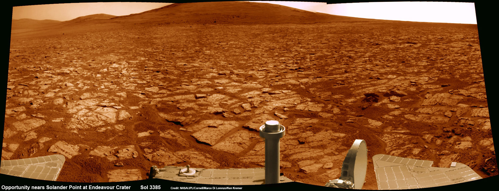
Opportunity rover’s 1st mountain climbing goal is dead ahead in this up close view of Solander Point along the eroded rim of Endeavour Crater. Opportunity will soon ascend the mountain in search of minerals signatures indicative of a past Martian habitable environment. This navcam panoramic mosaic was assembled from raw images taken on Sol 3385 (Aug 2, 2013). Credit: NASA/JPL/Cornell/Marco Di Lorenzo/Ken Kremer (kenkremer.com)
Opportunity rover’s 1st mountain climbing goal is dead ahead in this up close view of Solander Point at Endeavour Crater. Opportunity will ascend the mountain looking for clues indicative of a Martian habitable environment. This navcam panoramic mosaic was assembled from raw images taken on Sol 3385 (Aug 2, 2013).
Credit: NASA/JPL/Cornell/Marco Di Lorenzo/Ken Kremer (kenkremer.com)[/caption]
NASA’s most powerful Mars orbiter has been given the green light today (Aug. 5) to capture new high resolution spectral scans that are absolutely crucial for directing the long lived Opportunity rover’s hunt for signatures of habitability atop the intriguing mountain she will soon ascend.
In a plan only recently approved by NASA, engineers are aiming the CRISM mineral mapping spectrometer aboard the Mars Reconnaissance Orbiter (MRO) circling overhead to collect high resolution survey scans of Solander Point – Opportunity’s 1st mountain climbing goal along the rim of huge Endeavour Crater.
“New CRISM observations centered over Solander Point will be acquired on Aug. 5, 2013,” Ray Arvidson told Universe Today exclusively. Arvidson is the mission’s deputy principal scientific investigator from Washington University in St. Louis, Mo.
NASA’s decade old rover Opportunity is about to make ‘landfall’ at the base of Solander Point, the Martian mountain she will scale in search of the chemical ingredients that could sustain Martian microbes.
So the new spectral data can’t come back to Earth soon enough.
Currently, the science team lacks the same quality of high resolution CRISM data from Solander Point that they had at a prior stop at Cape York. And that data was crucial because it allowed the rover to be precisely targeted – and thereby discover a habitable zone, Arvidson told me.
“CRISM collected lots of overlapping measurements at Cape York to sharpen the image resolution to 5 meters per pixel to find the phyllosilicate smectite [clay minerals] signatures at Matejivic Hill on Cape York.”
“We don’t have that at Solander Point. We only have 18 meters per pixel data. And at that resolution you can’t tell if the phyllosilicate smectite [clay minerals] outcrops are present.”
Today’s new survey from Mars orbit will vastly improve the spectral resolution – from 18 meters per pixel down to 5 meters per pixel.
“5 meter per pixel CRISM resolution is expected in the along-track direction over Solander Point by commanding the gimbaled optical system to oversample that much,” Arvidson explained.
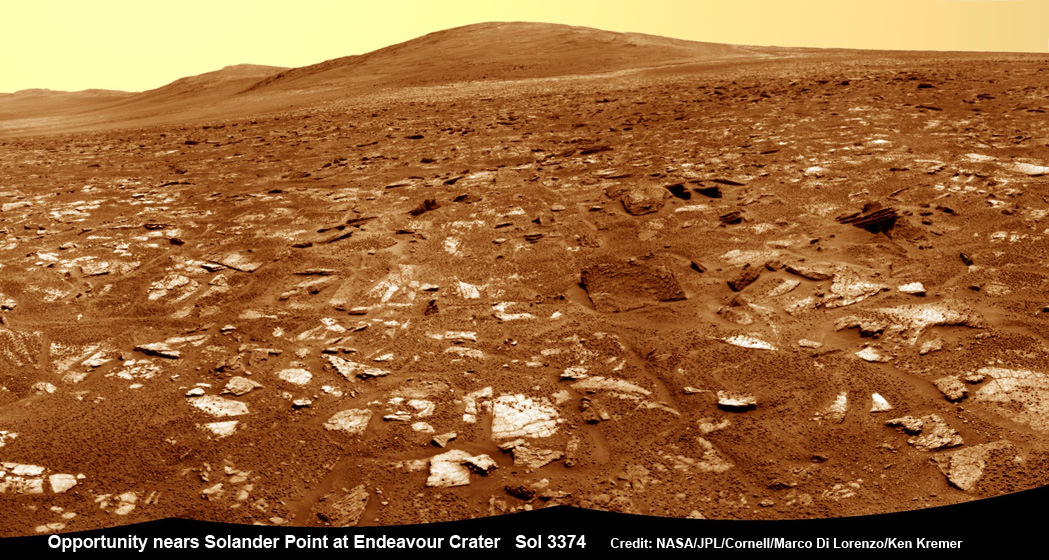
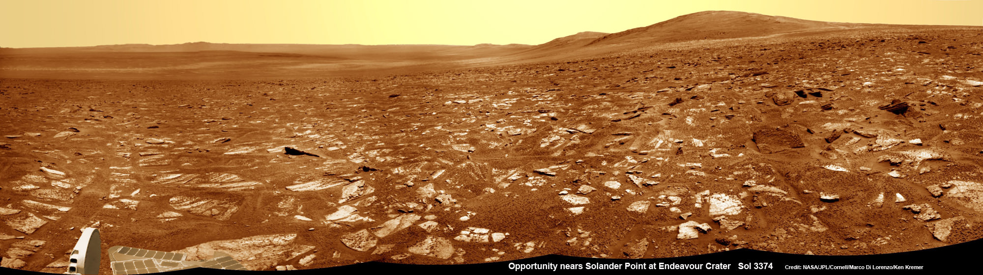
Opportunity rover’s view from very near the foothills of Solander Point looking along the rim and vast expanse of Endeavour Crater. Solander Point is the 1st Martian Mountain NASA’s Opportunity will climb and the rovers next destination. Solander Point may harbor clay minerals indicative of a past Martian habitable environment. This navcam mosaic was assembled from raw images taken on Sol 3374 (July 21, 2013). Credit: NASA/JPL/Cornell/Marco Di Lorenzo/Ken Kremer (kenkremer.com)
The new CRISM spectral survey from Mars is essential to enable the science team to carefully study the alien, unexplored terrain in detail and locate the clay minerals and other water bearing minerals, even before the rover arrives.
Clay minerals form in neutral pH water conducive to life.
Opportunity would then be commanded to drive to preselected sites to conduct “ground truth” forays at Solander.
That’s just like was done at Cape York and the “Esperance” rock loaded with clay minerals that turned into one of the “Top 5 discoveries of the mission” according to Arvidson and Steve Squyres, Opportunity’s Science Principal Investigator of Cornell.
But it took some cajoling and inter team negotiations to convince everyone to move forward with the special but crucial CRISM imaging plan.
Since MRO is getting on in age – it launched in 2005 – NASA and the spacecraft managers have to carefully consider special requests such as this one which involves slewing the MRO spacecraft instruments and therefore entails some health risks to the vehicle.
“CRISM has been operating at Mars since 2006 and sometimes the optics on a gimble have actuators that get stuck a little bit and don’t sweep as fully as planned.”
Nevertheless, Arvidson told me a few weeks ago he was hopeful to get approval.
“I suspect I can talk the team into it.”
And eventually he did! And informed me for the readers of Universe Today.
The fact that the Opportunity scientists already scored a ‘Science Home Run’ with their prior CRISM targeting request at Cape York certainly aided their cause immensely.
The new approved CRISM measurements due to be captured today will give Opportunity the best chance to be targeted to the most promising mineral outcrops, and as quickly as possible.
“With the coordinated observations from CRISM and Opportunity we will go into Solander Point a lot smarter!”
“And we’ll have a pretty good idea of what to look for and where,” Arvidson told me.
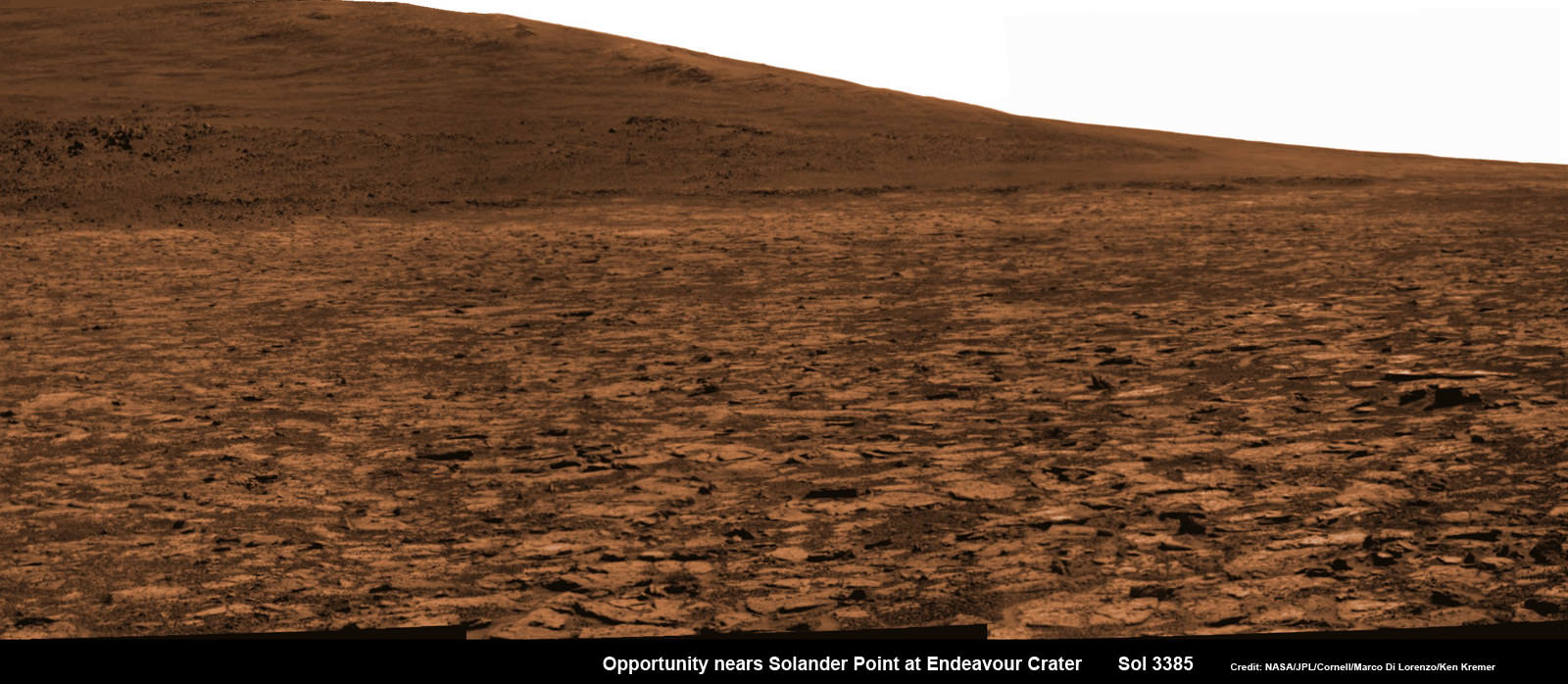
Opportunity snap up close view of the base of Solander Point and mountain slopes she will ascend soon. This hi res pancam camera mosaic was assembled from raw images taken on Sol 3385 (Aug 2, 2013). Credit: NASA/JPL/Cornell/ASU/Marco Di Lorenzo/Ken Kremer (kenkremer.com)
Today marks Opportunity’s 3389th Sol or Martian day roving Mars. Merely 90 days were expected!
Having completed her investigation of the rocky crater plains, the rover continues to drive south.
Any day now Opportunity will drive onto the Bench surrounding Solander and start a new phase of the mission.
Since she basically arrived at Solander with plenty of power and ahead of schedule prior to the onset of the 6th Martian winter, the robot has some spare time to investigate the foothills before ascending the north facing slopes.
“We will be examining the bench and then working our way counterclockwise to reach the steep slopes associated with the Noachian outcrops that are part of the Endeavour rim,” Arvidson said.
Ken Kremer Opportunity rover location in the latest MRO/HiRISE color image. The green line shows more or less the route we hope to take to the base of Solander point. Since it is only a couple of hundred meters away, we could be there is a couple of drives. Maybe by the end of next week. The label say “3374” but this is also roughly the location through 3379. Credit: NASA/JPL/Larry Crumpler
Traverse Map for NASA’s Opportunity rover from 2004 to 2013
This map shows the entire path the rover has driven during more than 9 years and over 3387 Sols, or Martian days, since landing inside Eagle Crater on Jan 24, 2004 to current location near foothills of Solander Point at the western rim of Endeavour Crater. Opportunity discovered clay minerals at Esperance – indicative of a habitable zone. Credit: NASA/JPL/Cornell/ASU/Marco Di Lorenzo/Ken Kremer
Opportunity rover’s view from very near the foothills of Solander Point looking along the rim and vast expanse of Endeavour Crater. Solander Point is the 1st Martian Mountain NASA’s Opportunity will climb and the rovers next destination. Solander Point may harbor clay minerals indicative of a past Martian habitable environment. This navcam mosaic was assembled from raw images taken on Sol 3374 (July 21, 2013). Credit: NASA/JPL/Cornell/Marco Di Lorenzo/Ken Kremer (kenkremer.com) See complete panoramic mosaic below
Opportunity rover’s view from very near the foothills of Solander Point looking along the rim and vast expanse of Endeavour Crater. This area exhibits gypsum signatures and numerous blocks of intriguing rock. Solander Point is the 1st Martian Mountain NASA’s Opportunity will climb and the rovers next destination. Solander Point may harbor clay minerals indicative of a past Martian habitable environment. This navcam mosaic was assembled from raw images taken on Sol 3374 (July 21, 2013). Credit: NASA/JPL/Cornell/Marco Di Lorenzo/Ken Kremer (kenkremer.com).
See complete panoramic mosaic below. Story updated with further details[/caption]
Exactly a decade after blasting off for the Red Planet and discovering a wide swath of water altered rocks and minerals in the ensuing years by exploring countless craters large and small, NASA’s intrepid Opportunity rover is just days away from arriving at her next big quest – a Martian mountain named Solander Point that may possess the key chemical ingredients necessary to sustain Martian life forms.
“We are parked 200 meters away from the bench at Solander Point,” Ray Arvidson told Universe Today exclusively. Arvidson is the mission’s deputy principal scientific investigator from Washington University in St. Louis, Mo. Furthermore, this area exhibits signatures related to water flow.
Solander Point also represents ‘something completely different’ – the first mountain the intrepid robot will ever climb.
“This will be Opportunity’s first mountain and the view from the ridge crest should be spectacular,” wrote Larry Crumpler, a science team member from the New Mexico Museum of Natural History & Science, in his latest field report about the 10 years ongoing Mars Exploration Rover (MER) mission.
Indeed the rover is now just a few short drives southward from making landfall on the northern tip of the point in her current trek across the relatively flat plains around the rim of Endeavour crater.
“We are now only about 180 meters from the new mountain, Solander Point.”
Opportunity rover location in the latest MRO/HiRISE color image. The green line shows more or less the route we hope to take to the base of Solander point. Since it is only a couple of hundred meters away, the rover could be there is a couple of drives. Maybe by the end of next week. The label say “3374” but this is also roughly the location through 3379. NASA/JPL/Larry Crumpler
But before moving onward, Arvidson explained that the rover will briefly pause here “at dark terrain” for some exciting science due to water related spectral observations from the CRISM instrument captured by NASA’s Mars Reconnaissance Orbiter (MRO) circling overhead.
“CRISM data [from Mars orbit] shows a relatively deep 1.9 micrometer absorption feature due to H2O-bearing minerals,” said Arvidson.
This past spring, Opportunity made the historic discovery of clay minerals and a habitable environment on a low hill called Cape York at the rover’s prior stop along the rim of Endeavour crater.
Solander was selected as the robot’s next destination because it simultaneously offers a goldmine of science as well as north facing slopes – where Opportunity’s solar wings can more effectively soak up the sun’s rays to generate life giving electrical power during the next Martian winter.
But since Opportunity is currently generating plenty of power from her solar arrays and arriving with a bonus cushion of time before the looming onset of her 6th Martian winter, the team decided to take a small detour to the southeast and spend several sols (or Martian days) exploring an area of intriguing geology of outcrops, gypsum signatures and more on the bench surrounding the base of the mountain.
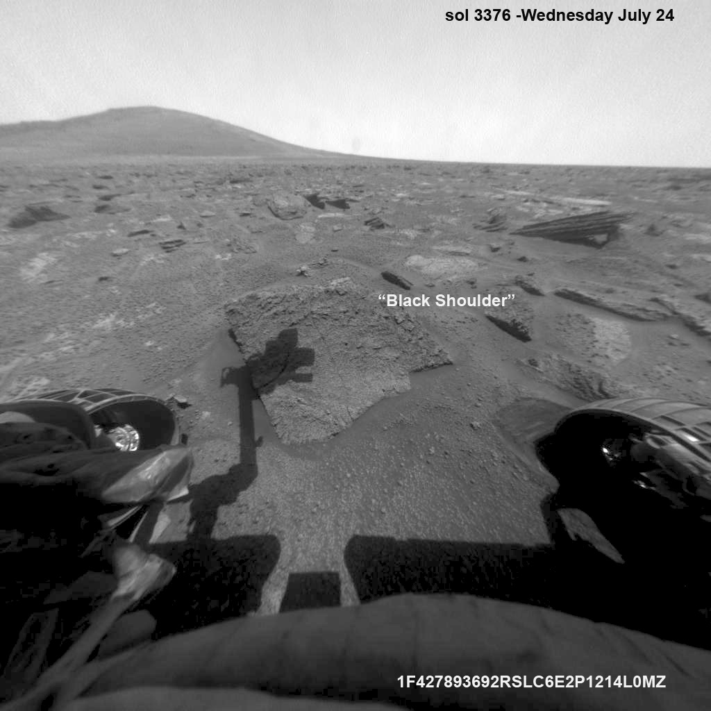
“We slowed down this week so that we could check out the rocks here where there is a strange hydration signature from orbital remote sensing,” says Crumpler.
“This is also an area that appears to have more large blocks in the HiRISE images [from Mars orbit], so we are checking out one of the blocks, “Black Shoulder”.
“We are hoping that the rocks on the ridge crest will be spectacular too,” notes Crumpler.
Opportunity rover’s view very near the foothills of Solander Point along the rim and vast expanse of Endeavour Crater. This area exhibits gypsum signatures and numerous blocks of intriguing rock. Solander Point is the 1st Martian Mountain NASA’s Opportunity will climb and the rovers next destination. Solander Point may harbor clay minerals indicative of a past Martian habitable environment. This navcam panoramic mosaic was assembled from raw images taken on Sol 3374 (July 21, 2013). Credit: NASA/JPL/Cornell/Marco Di Lorenzo/Ken Kremer (kenkremer.com)
Opportunity is using the science instruments on her 3 foot ( 1 meter) long robotic arm to conduct brief in-situ investigations of “Black Shoulder” with the Microscopic Imager (MI) and the Alpha Particle X-ray Spectrometer (APXS).
And …. it’s ‘Mountains Galore’ from here on out for the remainder of Opportunity’s Magnificent Mission to Mars.
Why? Because Opportunity is nearing the foothills of a long chain of eroded segments of the crater wall of Endeavour crater which spans a humongous 14 miles (22 kilometers) wide.
Solander Point may harbor deposits of phyllosilicate clay minerals – which form in neutral pH water – in a thick layer of rock stacks indicative of a past Martian habitable zone.
The rover team is discussing the best way to approach and drive up Solander.
“One idea is to drive part way up Solander from the west side of the rim, turn left and then drive down the steeper north facing slopes with the stratographic sections,” Ray Arvidson explained to Universe Today.
“That way we don’t have to drive up the relatively steeper slopes.”
“The rover can drive up rocky surfaces inclined about 12 to 15 degrees.”
“We want to go through the stratographic sections on the north facing sections,” Arvidson told me.
Opportunity rover moves closer to the foothills of Solander Point along the rim and vast expanse of Endeavour Crater. The rover investigated one of the large rocks near here with her microscopic imager and X-Ray spectrometer. Soon she will start climbing up Solander – her 1st Martian Mountain ascent. This navcam panoramic mosaic was assembled from raw images taken on Sol 3376 (July 23, 2013).
Credit: NASA/JPL/Cornell/Marco Di Lorenzo/Ken Kremer (kenkremer.com)
Today (July 28) is Sol 3380 for a mission that was only warrantied to last 90 Sols!
Opportunity’s total driving distance exceeds 23.6 miles (37.9 kilometers). She has snapped over 182,000 images.
The “work volume”. This view from the front hazcams shows the rock target that is being checked out before the final slog to the south. With luck, by the end of next week we will be plinking around the base of yonder mountain. “Plinking” is a geological term for wandering around with your hammer trying to get a handle on the local outcrops before plunging ahead with mapping and asking the rocks serious questions. Credit: NASA/JPL/Larry Crumpler
Meanwhile on the opposite side of Mars at Gale Crater, Opportunity’s younger sister rover Curiosity also discovered a habitable environment originating from a time when the Red Planet was far warmer and wetter billions of years ago.
And like Opportunity, Curiosity is also trekking towards a mountain rich in sedimentary layers hoping to unveil the mysteries of Mars past. But Curiosity likely won’t arrive at 3.4 mile (5.5 km) high Mount Sharp for another year.
Traverse Map for NASA’s Opportunity rover from 2004 to 2013
This map shows the entire path the rover has driven during more than 9 years and over 3374 Sols, or Martian days, since landing inside Eagle Crater on Jan 24, 2004 to current location near foothills of Solander Point at the western rim of Endeavour Crater. Opportunity discovered clay minerals at Esperance – indicative of a habitable zone. Credit: NASA/JPL/Cornell/ASU/Marco Di Lorenzo/Ken Kremer
…………….
Learn more about Mars, Curiosity, Opportunity, LADEE, MAVEN, Antares and more at Ken’s upcoming lecture presentations
Aug 12: “RockSat-X Suborbital Launch, LADEE Lunar & Antares Rocket Launches from Virginia”; Rodeway Inn, Chincoteague, VA, 8 PM


![MER10-SpiritAndOpportunity_ByTheNumbers[1]](https://www.universetoday.com/wp-content/uploads/2014/01/MER10-SpiritAndOpportunity_ByTheNumbers1.jpg)