When did the First Continents Appear in the Universe?

Continents might be necessary for life, especially complex life. This image shows super-continent Pangaea during the Permian period (300 - 250 million years ago). Credit: NAU Geology/Ron Blakey

On Earth, continents are likely necessary to support life. Continents ‘float’ on top of the Earth’s viscous mantle, and heat from the planet’s core keeps the mantle from solidifying and locking the continents into place.

The core is hot because of the presence of radioactive elements that came from neutron star collisions. It should be possible to calculate when the first continents formed in the Universe.

So that’s what one researcher did.

Continue reading “When did the First Continents Appear in the Universe?”

What’s the Best Mix of Oceans to Land for a Habitable Planet?

A new study asks what ratio of land to ocean is best for habitability? Image Credit: Reto Stöckli, Render by Robert Simmon. Based on data from the MODIS Science Team

Earth is about 29% land and 71% oceans. How significant is that mix for habitability? What does it tell us about exoplanet habitability?

Continue reading “What’s the Best Mix of Oceans to Land for a Habitable Planet?”

3 Billion Years Ago, the World Might Have Been a Waterworld, With No Continents At All

Artist's depiction of a waterworld. A new study suggests that Earth is in a minority when it comes to planets, and that most habitable planets may be greater than 90% ocean. Credit: David A. Aguilar (CfA)

Evidence from an ancient section of the Earth’s crust suggest that Earth was once a water-world, some three billion years ago. If true, it’ll mean scientists need to reconsider some thinking around exoplanets and habitability. They’ll also need to reconsider their understanding of how life began on our planet.

Continue reading “3 Billion Years Ago, the World Might Have Been a Waterworld, With No Continents At All”

Earth Just Got A New Continent

This simplified map of the continents shows the new continent Zealandia in grey. Image: Mortimer et. al. 2017, GSA Today.

We tend to lump New Zealand and Australia together. They’re similar culturally and share the same geographical position, relative to North America and Europe, anyway. But according to a new paper published in the Geological Society of America Today, it looks like New Zealand and their neighbor New Caledonia are actually their own continent: ‘Zealandia.’

Continent means something different to geographers and geologists. To be considered a geological continent, like Zealandia, the area in question has to satisfy a few conditions:

  • the land in question has to be higher than the ocean floor
  • it has to include a broad range of siliceous igneous, metamorphic, and sedimentary rocks
  • it has to have thicker crust than the ocean floor that surrounds it
  • it has to have well-defined limits, and be large enough to be considered a continent

In Geology, the first three points are well-understood. But as the authors say in the introduction to their paper, “…the last point—how “major” a piece of continental crust has to be to be called a continent—is almost never discussed… .” Since the Earth has so many micro-continents and continental fragments, defining how large something has to be to be called a continent is challenging. But the researchers did their homework.

They noted that the term “Zealandia” has been used before to describe New Zealand and surrounding regions. But the boundaries were never fully explored. 94% of this new continent is submerged, which helps explain why it’s taken this long to be identified.

This map shows the spatial limits of Zealandia. Note the dotted red line that delineates continental crust from ocean crust. Zealandia is also bisected by a plate boundary between the Pacific Plate and the Australian Plate. Image: Mortimer et. al. 2017, GSA Today

Zealandia seemed to be a collection of broken pieces, but new data collected over the years has challenged that interpretation. Recent satellite data has given us new gravity and elevation maps of the seafloor. This data has shown that Zealandia is a unified region large as large as India.

“This is not a sudden discovery but a gradual realization; as recently as 10 years ago we would not have had the accumulated data or confidence in interpretation to write this paper.”

As the authors point out in their paper, it took a while to determine that Zealandia is a continent. There was no Eureka moment. “This is not a sudden discovery but a gradual realization; as recently as 10 years ago we would not have had the accumulated data or confidence in interpretation to write this paper.”

Besides satisfying our intellectual curiosity about our planet, the discovery is important for other reasons. A proper understanding of the plate structures and continental boundaries is important to other sciences, and may trigger further understandings that we can’t predict yet. It may also point to other areas of research.

Also, many treaties rely on the agreed upon delineation of maritime and continental boundaries, including rights to fish stocks and underground resources. While the recognition of Zealandia seems clear from a scientific standpoint, it remains to be seen if it will be accepted politically.

How Do The Tides Work?

How Do The Tides Work?

Anyone who lives close to ocean is familiar with the tides. And you probably know they have something to do with the Moon. But how do the tides work? Do other planets experience tides?

Just what the heck are tides? Some kind of orbit jiggle jello effect from the magic Etruscan space-whale song? Is it an unending slap-back of gravitometric Malthusian resonance originating from the core of the Sun’s crystalline liver-light organelles? Is it all the plankton agreeing to paddle in the same direction at their monthly oceanic conferences?

As certain as I am that you enjoy my word terminology salads, with apologies to Papa Bear, we both know tides are caused by the gravitational interaction with the Moon. You would think we’d have only one high tide and one low tide, with the Moon pulling the Earth’s water towards it. Moon goes one side, water rushes over to that side, moon goes to other side, water chases around to follow it. But the tides make the water levels appear to rise twice a day, and lower twice a day in 6 hour increments. So, it’s clearly more complicated than that.

The gravity from the Moon does pull the water towards it. That’s what gives you the highest tide of the day. It’s a bulge of water that follows the Moon around and around as the Earth rotates. This makes sense to us. But then Earth itself is pulled with a little less gravity than the water towards the Moon and, the water on the opposite side of the Earth is pulled with even less gravity, and so you wind up with another bulge on the opposite side of the Earth.

So from our perspective, you end up with a bulge of water towards the Moon, and a bulge away from it. The part of the Earth with the water getting pulled towards the Moon experiences a high tide, and same with the part on the opposite side of the Earth with the other bulge. Correspondingly, the parts of the Earth at right angles are experiencing low tides.

It would be hard enough to predict with a simple spherical Earth covered entirely by water, but we’ve got continents and coastlines, and that makes things even more complicated. The levels that the tides rise and fall depend quite a bit on how easily the water can move around in a region. That’s why you can get such big tides in places like the Bay of Fundy in Canada.

The Moon over Gulf Islands National Seashore near Navarre Beach, Florida. Credit: Mindi Meeks.

Our Sun also contributes to the tides. Surprisingly, it accounts for about 30% of the them. So when the Sun and the Moon are lined up in the sky, you get the highest high tides and the lowest low tides – these are Spring Tides. And then when the Sun and Moon are at right angles, you get the lowest high tides and the highest low tides. These are Neap Tides.

Tidal forces can be very powerful. They can tear galaxies apart and cause moons to get shredded into pieces. Perhaps the most dramatic example is how Jupiter’s enormous gravity pulls on Io so strongly that its surface rises and falls by 100 meters. This is 5 times greater than the Earth’s biggest water tides. This constant rise and fall heats up the moon, giving it non-stop volcanism.

What do you think? Share your favorite tidal science fact in the comments below. And if you like what you see, come check out our Patreon page and find out how you can get these videos early while helping us bring you more great content!

What Is Pangaea?

Continents might be necessary for life, especially complex life. This image shows super-continent Pangaea during the Permian period (300 - 250 million years ago). Credit: NAU Geology/Ron Blakey

So, you are curious about what is Pangaea? It was the supercontinent that existed 250 million years ago during the Paleozoic and Mesozoic eras. During the ensuing millenia, plate tectonics slowly moved each continent to its current position on the planet. Each continent is still slowly moving across the face of our world.

The breaking up and formation of supercontinents appears to have happened several times over Earth’s history with Pangaea being one among many. The next-to-last one, Pannotia, formed about 600 million years ago during the Proterozoic eon. Pannotia included large amounts of land near the poles and only a relatively small strip near the equator connecting the polar masses.

60 million years after its formation Pannotia broke up, giving rise to the continents of Laurentia, Baltica, and Gondwana. Laurentia would eventually become a large portion of North America, the microcontinent of Avalonia(a small portion of Gondwana) would become the northeastern United States, Nova Scotia, and England. All of these came together at the end of the Ordovician.

While this was happening, Gondwana drifted slowly towards the South Pole. These were the early steps in the formation of Pangaea. The next step was the collision of Gondwana with the other land mass. Southern Europe broke free of Gondwana. By late Silurian time, North and South China rifted away from Gondwana and started to head northward across the shrinking Proto-Tethys Ocean.

Movement continued slowly until the land masses drifted until their current positions. The list of oceans and microcontinents is too long to include in this article. We have many articles about this full process here on Universe Today. The evidence for Pangaea lies in the fossil records from the period. It includes the presence of similar and identical species on continents that are now great distances apart.

Additional evidence for Pangaea is found in the geology of adjacent continents, including matching geological trends between the eastern coast of South America and western Africa. The polar ice cap of the Carboniferous Period covered the southern end of Pangaea. Glacial deposits of the same age and structure are found on many separate continents which would have been together in the continent of Pangaea.

We know that the existence of supercontinents has been proven. We know that they have existed at different times in the Earth’s history. Also, we know that the tectonic plates are still moving. Is it possible that there will be another supercontinent someday in the distant future.

We have written many articles about Pangaea for Universe Today. Here’s an article about the Continental Drift Theory, and here’s an article about the continental plates.

If you’d like more info on Pangaea, check out the Pangaea Interactive Map Game. And here’s a link to NASA’s Continents in Collision: Pangaea Ultima.

We’ve also recorded an episode of Astronomy Cast all about Plate Tectonics. Listen here, Episode 142: Plate Tectonics.

Sources:
http://en.wikipedia.org/wiki/Pangaea
http://pubs.usgs.gov/gip/dynamic/historical.html
http://library.thinkquest.org/17701/high/pangaea/

How Many Continents Are There?

The current tectonic plates.

[/caption]Not everyone on this planet is in agreement as with regards to the total number of continents. So how many continents are there then, according to the disagreeing parties?

Well, in Russia, Eastern Europe and Japan, the people there consider the continents of Europe and Asia as one, known as Eurasia. In other places in the world, North and South America are combined as one American continent while separating Europe and Asia instead. Thus, according to these two views, there should only be 6 continents.

There are even geographical views that prefer the presence of both a Eurasian as well as one American continent. These geographers therefore contend that there should only be 5 continents.

And if you thought that would be the lowest number, think again. There are others still who are more comfortable with a 4-continent view.

These people argue that, since Europe and Asia are actually part of one great land mass and that Asia and Africa are actually joined by an isthmus (Isthmus of Suez), as are the two Americas (being joined by the Isthmus of Panama), then there should be an Afro-Eurasian continent in addition to one American continent, Antarctica, and Australia.

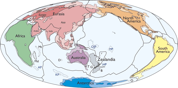
But how many continents are there according to the more widely accepted view? In the most widely accepted view, there are 7 continents all in all: Asia, Africa, Europe, North America, South America, Antarctica, and Australia.

This model is preferred by the Chinese and majority of the English-speaking countries.

The final verdict as to how many continents are there might lean more on the larger numbers once the effects of global warming kick in. Once sea water levels rise, the separation between the two Americas as well as that between Africa and Asia will be more noticeable. Only the combined Europe and Asia model (a.k.a. 6-continent model) and the 7-continent model would remain.

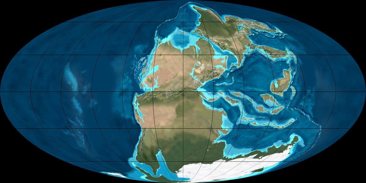
Hundreds of millions of years from now, we really don’t know how many continents there would be. According to the continental drift theory, moving tectonic plates may rearrange the pieces of the puzzle that are the Earth’s continents.

What used to be one super continent, known as Pangaea has now been broken into 4, 5, 6, or 7 continents – depending on which side you’re more comfortable with. Therefore, its plausible, the Earth being round and all, that some of these continents will later on combine after drifting away for some time.

You can read more about plate tectonics here in Universe Today. Here are the links:

There’s more about it at USGS. Here are a couple of sources there:

Here are two episodes at Astronomy Cast that you might want to check out as well:

Sources:
Wikipedia
National Geographic