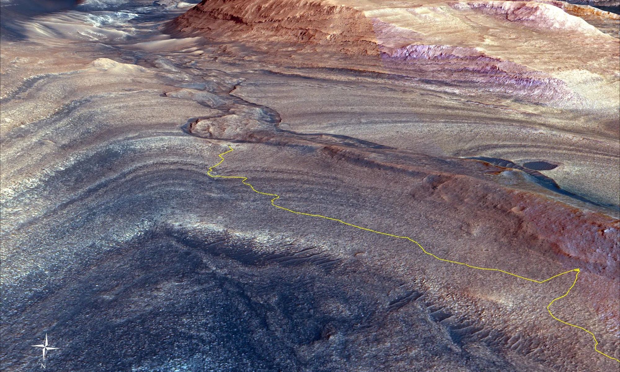
The steep path NASA’s Curiosity Mars rover took to reach Gediz Vallis channel is indicated in yellow in this visualization made with orbital data. At lower right is the point where the rover veered off to get an up-close look at a ridge formed long ago by debris flows from higher up on Mount Sharp. NASA/JPL-Caltech/UC Berkeley
Like a pilgrim seeking wisdom, NASA’s MSL Curiosity has been working its way up Mt. Sharp, the dominant central feature in Gale Crater. Now, almost 12 years into its mission, the capable rover has reached an interesting feature that could tell them more about Mars and its watery history. It’s called the Gediz Vallis channel.
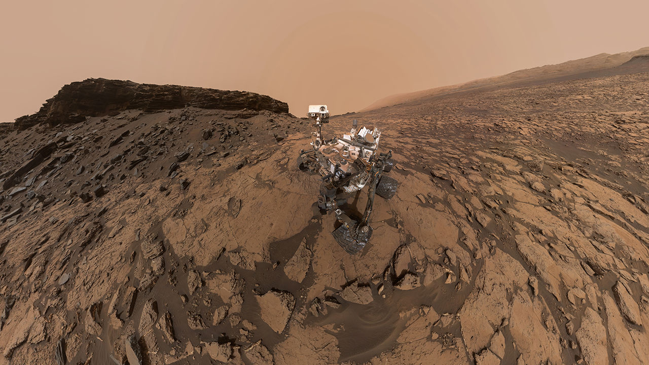
Panoramic image of the Curiosity rover, from September 2016. The pale outline of Aeolis Mons can be seen in the distance. Credit: NASA/JPL-Caltech/MSSS
Some very clever people have figured out how to use MSL Curiosity’s navigation sensors to measure the gravity of a Martian mountain. What they’ve found contradicts previous thinking about Aeolis Mons, aka Mt. Sharp. Aeolis Mons is a mountain in the center of Gale Crater, Curiosity’s landing site in 2012.
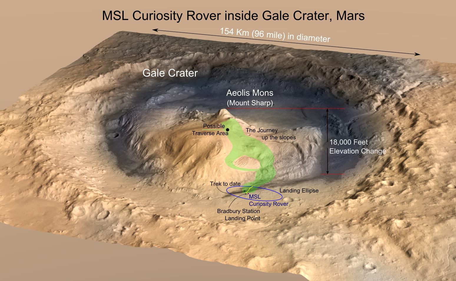
Gale Crater is a huge impact crater that’s 154 km (96 mi) in diameter and about 3.5 billion years old. In the center is Aeolis Mons, a mountain about 5.5 km (18,000 ft) high. Over an approximately 2 billion year period, sediments were deposited either by water, wind, or both, creating the mountain. Subsequent erosion reduced the mountain to its current form.
Now a new paper published in Science, based on gravity measurements from Curiosity, shows that Aeolis Mons’ bedrock layers are not as dense as once thought.
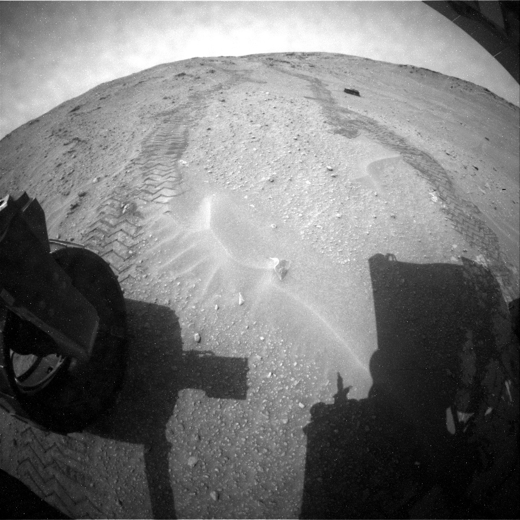
Rover tracks and Martian sand as seen from the rear hazcam of NASA's Curiosity rover. Credit: NASA/JPL-Caltech
After a couple of years of racing towards Mount Sharp (Aeolis Mons), now it’s time for the Curiosity rover to get a better look at its Martian surroundings. The rover has reached its stated science destination and mission planners say now is the time to stop the driving and get deep into the science.
NASA is on the hunt for signs of habitability on the Red Planet, and officials hope that the layers of this big mountain will yield a wealth of information on Martian history.
“This first look at rocks we believe to underlie Mount Sharp is exciting because it will begin to form a picture of the environment at the time the mountain formed, and what led to its growth,” stated Ashwin Vasavada, Curiosity’s deputy project scientist in a press release from late September.
As Curiosity drills and analyzes rocks at its feet, it continues to send back stunning pictures of its surroundings. Check out a sample from this week below.
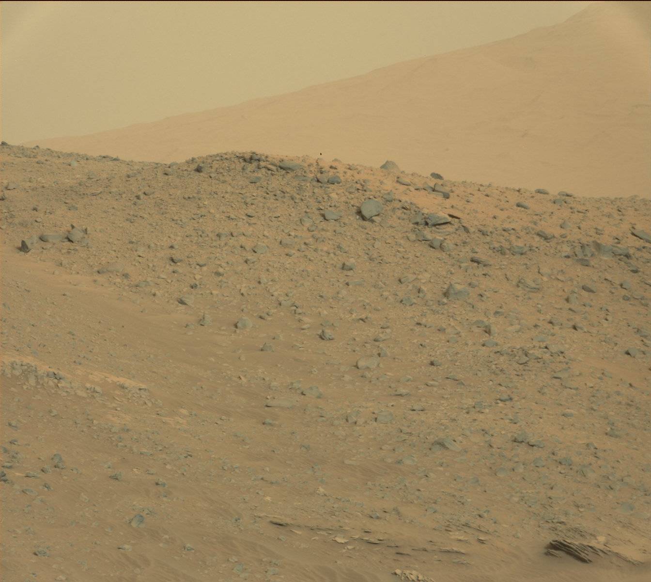
Mars Curiosity peers over a craggy ridge on Oct. 7, 2014 (Sol 771). Credit: NASA/JPL-Caltech/MSSS
Martian hills beckon in this photo from the Curiosity rover taken Oct. 7, 2014, on Sol 771. Credit: NASA/JPL-Caltech/MSSS
Close-up of a brush instrument on the Mars Curiosity rover on Oct. 3 (Sol 767). Credit: NASA/JPL-Caltech/MSSS
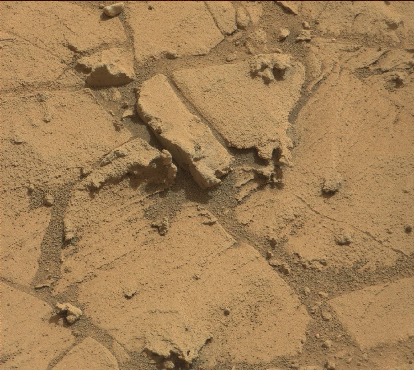
Cracked terrain underfoot seen by the Martian Curiosity rover on Oct. 7, 2014 (Sol 771). Credit: NASA/JPL-Caltech/MSSS
MRO image of Gale Crater illustrating the landing location and trek of the Rover Curiosity. Curiosity's images and data show that the Gale Crater held water for much longer than thought. (Credits: NASA/JPL, illustration, T.Reyes)
Scientists at the Jet Propulsion Laboratory have announced that the Mars Science Lab (MSL), Curiosity Rover, has reached the base of the central peak inside Gale Crater, Aeolis Mons also known as Mount Sharp. Mount Sharp is a prime objective of NASA’s Curiosity journey. The mountain is like a layer cake, holding a chronology of past events, one after the other, stacked upon each other over billions of years. It took two years and one month to reach this present point and what lies ahead is the beginning of an upward trek towards the peak of Mount Sharp, 5500 meters (18,000 feet) above the floor of Gale Crater. However, it is worth a look back and to consider what Mount Sharp represents to the mission.
For over 17 years, NASA robotic spacecraft have maintained a constant presence above or upon the surface of Mars. The Mars Pathfinder mission arrived on July 4, 1997, then quickly followed by Mars Global Surveyor on September 11 and since this time, there has always been at least one active Mars mission.
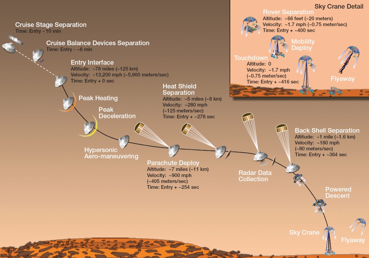
“Seven Minutes of Terror” – the Entry, Descent and Landing (EDL) of the Mars Science Lab (MSL) – Mars Curiosity Rover. (Credit: NASA/JPL)
On November 26, 2011, the voyage of Mars Curiosity Rover began as a trek across 320 million kilometers (200 million miles) of the inner Solar System and culminated in the coined “Seven Minutes of Terror”. For seven long minutes, the MSL, the Mars Curiosity Rover, plowed straight into the Martian atmosphere – the entry, deployed a parachute – the descent, to slow down to about 320 km/hour (200 mph) then the Sky Crane with Rover under foot was released – the landing. With only seconds before an imminent hard impact, the Sky Crane hit the breaks, firing its rockets, then released Curiosity Rover on a tether. This was the Entry, Descent and Landing (EDL). All the while, it was the computer inside the Rover in control. When the tether was cut, the Sky Crane was forced to switch to a simpler processor within its system to complete a final scuttling of itself a few hundred meters away.
The Sky Crane gently lowered Curiosity to the landing point, christened Bradbury Station after the celebrated science fiction writer, Ray Bradbury, writer of the Martian Chronicles(c.1950), who passed away at age 91, 61 days before the landing on August 5, 2012. (recommended video – R. Bradbury reading “If Only We had been Taller” at the public event marking the arrival of Mariner 9 at Mars, November 12, 1971)
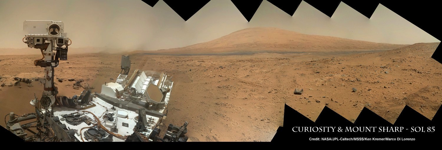
The ultimate Selfie – a self-protrait taken on anoher planet. This is the capability of the Mars Hand Lens Imager (MAHLI) camera, one of 5 instruments on the turret at the end of the 2.1 meter (7 ft), 30 kg (66 lb) Robotic Arm. On numerous occasions, Curiosity has taken self-portraits, many as mosaics. This on is on Sol (Mars day) 85, post landing, showing Curiosity with its destination – Aeolis Mons (Mt. Sharp) in the background. (Credit: NASA/JPL-Caltech/MSSS/Ken Kremer/Marco Di Lorenzo, “Curiosity Celebrates 90 Sols Scooping Mars and Snapping Amazing Self-Portrait with Mount Sharp“)
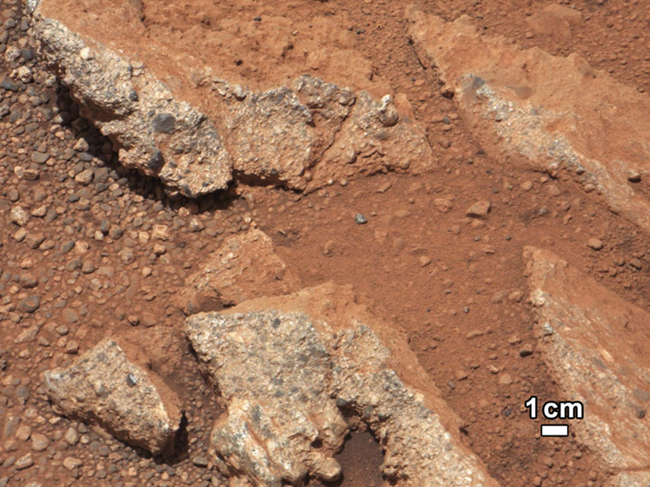
September 27, 2012: A rock outcrop called Link pops out from a Martian surface taken by the 100-millimeter Mast Camera on NASA’s Curiosity Mars rover September 2, 2012. Rounded gravel fragments, or clasts, up to a couple inches (few centimeters) in size are in a matrix of white material. The outcrop characteristics are consistent with a sedimentary conglomerate, or a rock that was formed by the deposition of water and is composed of many smaller rounded rocks cemented together. Scientists enhanced the color in this version to show the Martian scene as it would appear under the lighting conditions we have on Earth, which helps in analyzing the terrain. (NASA/JPL-Caltech/MSSS/Handout/Reuters)
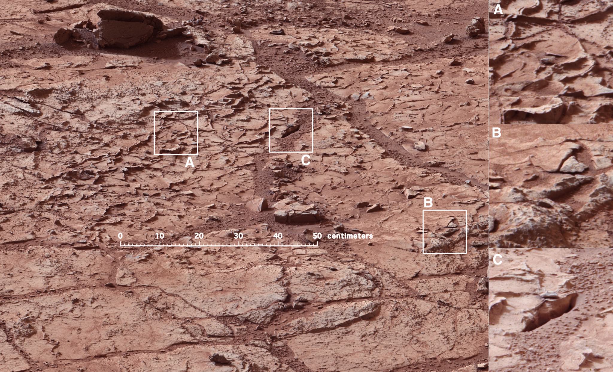
Mars Curiosity at the “John Klein” site in Yellow Knife Bay on January 10, 2013 (Mars Sol 153). The Mastcam mosaic was taken from 5 meters (16 ft). The area is full of fractures and veins with intervening rock with concretions (small spherical concentrations of minerals). The enlargements show particular areas of interest. (A) Ridge-like veins protruding from the surface. (B) Shows discontinuities in the veins that likely extend beneath the surface. (C) Shows a hole developed in the sand that overlies a fracture, implying infiltration of sand down into the fracture system. To this author, the area around (A) seems similar to the remnants of dried mud chips or scales one finds in the dry areas of estuaries on Earth. (Credits: NASA/JPL)
What has followed in the last 25 months since the landing is simply staggering. Mars Curiosity Rover, with the most advanced array of instruments and tools ever delivered to a celestial body, has already delivered an immense trove of images and scientific data that is improving and changing our understanding of Mars.
HIRISE images from the orbiting MRO spacecraft are used to show the old and new routes of NASA’s Mars Curiosity rover. The new route provides excellent access to many features in the Murray Formation. And it will eventually pass by the Murray Formation’s namesake, Murray Buttes, previously considered to be the entry point to Mt. Sharp. (Credit: NASA/JPL-Caltech/Univ. of Arizona)
Curiosity had been making progress towards an entry point to Mount Sharp called Murray Buttes, however, because of challenges that the terrain posed – sand dunes and treacherous rocks, they have chosen to enter at Pahrump Hills. Furthermore, the new entry to the lower slopes of Mount Sharp are considered scientifically more interesting. The boundary between the mountain and the crater-floor deposits is not an exact one but NASA scientists explained the reason for the announcement at this point:
“Both entry points lay along a boundary where the southern base layer of the mountain meets crater-floor deposits washed down from the crater’s northern rim.” The terrain is now primarily material from the mountain from here on upward.
Image taken by the MastCam of Curiosity Rover on August 23, 2012 which shows the buttes representing the base of Mount Sharp, including Murray Buttes. Today, two years later, Mars Curiosity now stands at entry points in the region of the buttes at 6.6 km (direct line distance). In the middle of the image is the boulder-strewn area in which much of Curiosity’s wheel damage occurred. At top are the expansive series of sendiments that is the great interest of Mars researchers. (Credit: NASA/JPL)
Mount Sharp is anything but the normal central peak of an impact crater. Gale crater at 154 km (96 miles) in diameter is what is called a complex crater. Beyond a certain size, depending on the gravity of the planet, craters will have a central peak. It is similar to the spike of water which is thrust upwards when you drop an object into a pool of water. Like the spike of water, an impact, thrusts regolith upwards and it collapses and coalesces into a central peak. However, with Mount Sharp there is something more. If the peak was nothing but a central impact peak, NASA with Mars Curiosity would not be trekking inside Gale Crater.
As data and analysis has accumulated from not just Mars Curiosity Rover but rather from all the active Mars missions, the models and hypotheses describing the structure and morphology on Mars have become more complex. This model and explanation of how Mount Sharp built up over billions of years uses deposition of ice and dust. Click to enlarge and review the five steps to making a layer cake mountain – Mount Sharp. (Credit: Illustration presented by Paul Niles (NASA Johnson Space Center) and Joseph Michalski (Planetary Science Insitute, UK)at the 43rd Lunar and Planetary Science Conference, The Woodlands, Texas)
Mars scientists believe that Gale crater after its creation was completely filled with sedimentary material from a series of huge floods passing over the surrounding terrain or by dust and ice deposits such as happened at the Martian polar caps. The deposition over 2 billion years left a series sedimentary layers that filled the crater.
Following the deposition of the layers, there was a long period of erosion which has finally led to the condition of the crater today. The erosion by some combination of aeolean (wind) forces and water (additional flooding), scooped out the huge crater, re-exposing most of the original depth. However, covering the original central peak are many sedimentary layers of debris. Gale crater’s original central peak actually remains completely hidden and covered by sedimentation. This is what has attracted scientists with Curiosity to the base of Mount Sharp.
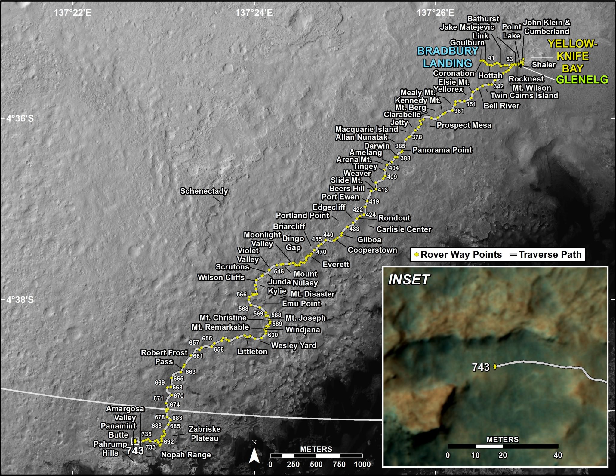
The trek of NASA’s Curiosity Rover from Bradbury Station (landing site, Sol 1) up to Martian Sol 743. The announcement that Curiosity had reached the base of Mt. Sharp is Sol 746. On Martian Sol 675, the Rover took its first step beyond its landing ellipse. (Credit: NASA/JPL)
Within the sedimentary layers covering Mount Sharp, there is a sequential record of the events that laid down the layers. Embedded in each of those layers is a record of the environmental conditions on Mars going back over 2 billion years. At the base are the oldest sedimentary layers and as Curiosity climbs the flanks of the mountain, it will step forward in time. The advanced instrumentation residing on and inside Curiosity will be able to analyze each layer for material content and also determine its age. Each layer and its age will reveal information such as how much water was present, whether the water was alkaline or acidic, if there is any organic compounds. The discovery of organic compounds on Mount Sharp could be, well, Earth shaking. There are organic compounds and then there are organic compounds that are linked to life and this search for organics is of very high importance to this mission.
Already, over the two year trek, Curiosity has seen numerous signs of the flow of water and sedimentation. At its first major waypoint, Glenelg, Curiosity stepped into an area called Yellow Knife Bay that showed numerous signs of past water. There were veins of magnesium salt deposits embedded in the soil, sedimentation and even conglomerate rock such as that found in river beds.
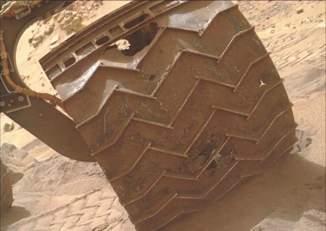
In late 2013, wear and tear accelerated on Curiosity’s wheels, the result of crossing boulder-strewn terrain. Clearly signs of punctures, tears and dents are seen in the photo taken by Curiosity performing a self-inspection. While it certainly raised alarm, mission planners remain confident that it can be handled and will not limit the duration of the mission.(Credits: NASA/JPL)
There is another side to the terrain that Curiosity is traversing. The crater floor, essentially a flood plain has been particularly hard on the mobility system of Curiosity. This is to say that the sharp rocks it continues to encounter under foot are taking a toll on the wheels. Curiosity is now being operated in reverse in order to reduced the impact forces on its wheels.
Furthermore, while scientists are helping to choose the path of the rover, the Curiosity drivers who must assess the field ahead must find paths with fewer sharp rocks in order to slow the damage being done. The Mars Curiosity team is concerned but remain confident that the mobility system will be capable of surviving the ten year life span of the rover’s power supply. So, the momentous occasion is hardly a time to pause and reflect, the trek moves upward, northward to see what the layers on Mount Sharp will reveal.
There are competing hypotheses on how Mount Sharp evolved. Here are two worthy web pages with additional reading.
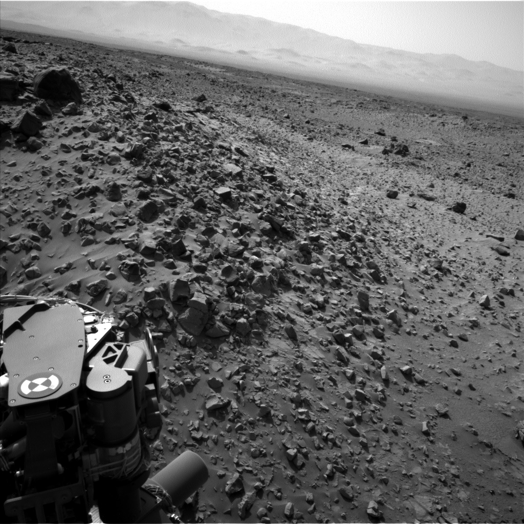
NASA's Curiosity rover looks across a rock field in this raw picture from Mars taken Aug. 8, 2014. Credit: NASA/JPL-Caltech
This picture alone illustrates the challenge NASA has as it slowly moves the Curiosity rover across Mars to its mountainous destination. You can see rocks surrounding the rover on Sol 713 (on Aug. 8), which is a challenge because of the ongoing wear and tear on Curiosity’s aluminum wheels.
In mid-July, Curiosity crossed one of the most difficult stretches of terrain yet since NASA spotted the damage and took measures to mitigate further problems, which includes picking out the smoothest terrain possible for its rover — which just celebrated two years on the Red Planet.
“For about half of July, the rover team at NASA’s Jet Propulsion Laboratory in Pasadena, California, drove Curiosity across an area of hazardous sharp rocks on Mars called ‘Zabriskie Plateau’,” NASA wrote in a recent press release.
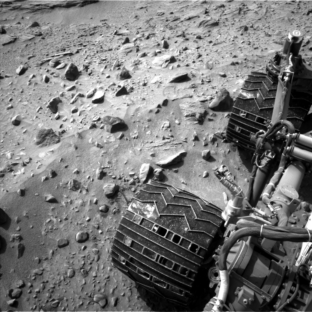
A closeup of Curiosity’s wheels on Mars on Aug. 9, 2014. Credit: NASA/JPL-Caltech
“Damage to Curiosity‘s aluminum wheels from driving across similar terrain last year prompted a change in route, with the plan of skirting such rock-studded terrain wherever feasible. The one-eighth mile (200 meters) across Zabriskie Plateau was one of the longest stretches without a suitable detour on the redesigned route toward the long-term science destination.”
The rover is planning to make its way up the slope of science destinations on Mount Sharp, which is about two miles (3 kilometers) away. NASA pointed out that an interim stop for the rover will take place less than a third of a mile away (500 meters).
“The wheels took some damage getting across Zabriskie Plateau, but it’s less than I expected from the amount of hard, sharp rocks embedded there,” added Jim Erickson, project manager for Curiosity at NASA’s Jet Propulsion Laboratory, in a statement.
A low view of the terrain taken by the Mars Curiosity rover in August 2014. Credit: NASA/JPL-Caltech
“The rover drivers showed that they’re up to the task of getting around the really bad rocks. There will still be rough patches ahead. We didn’t imagine prior to landing that we would see this kind of challenge to the vehicle, but we’re handling it.”
Curiosity has driven out of its landing ellipse and will continue the trek to the mountain, stopping to perform science along the way.
NASA plans to heavily borrow from Curiosity’s design for its next rover, called Mars 2020. The science instruments for that rover were selected last week. While Curiosity was made to seek potentially habitable environments in the past or present, Mars 2020 will have the capability to search for organic materials that could indicate precursors to life.
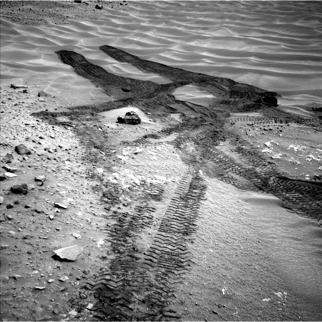
The Mars Curiosity rover leaves tracks in the sand in this picture taken Aug. 9, 2014. Credit: NASA/JPL-Caltech
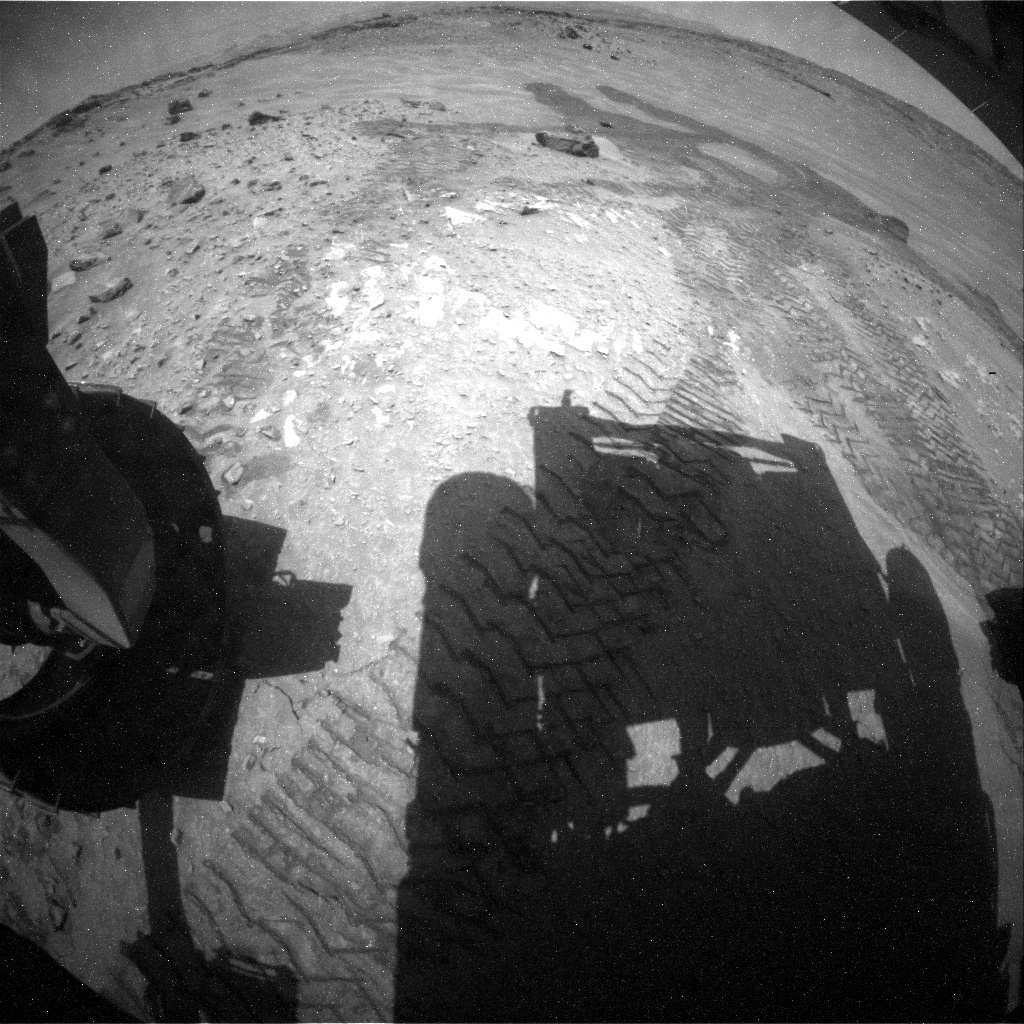
A shadow of Mars Curiosity lies across the surface in this picture taken Aug. 9, 2014. Credit: NASA/JPL-Caltech
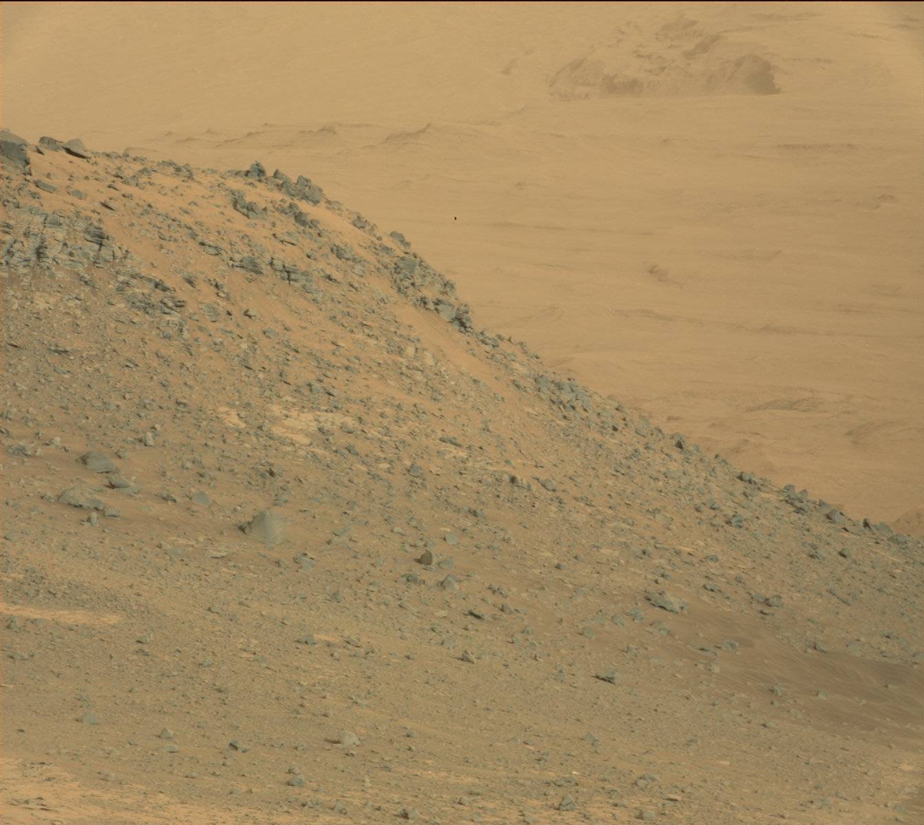
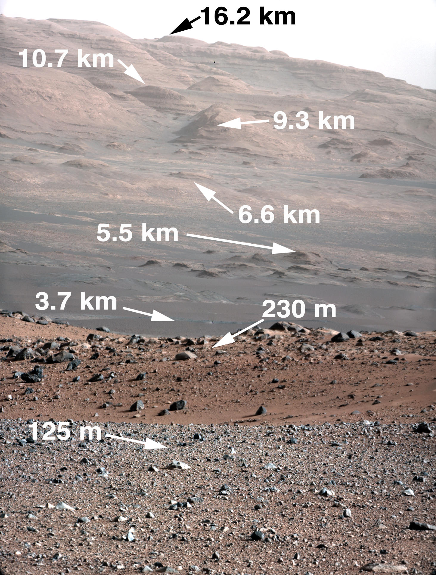
Curiosity is only eight miles (five kilometers) from a hematite-rich ridge at the bottom of Mount Sharp (Aeolis Mons). Credit: NASA/JPL-Caltech/MSSS
So Curiosity has been on Mars for an Earth year and is now, slowly, making its way over to that ginormous mountain — Mount Sharp, or Aeolis Mons — in the distance. The trek is expected to take at least until mid-2014, if not longer, because the rover will make pit stops at interesting science sites along the way. But far-thinking scientists are already thinking about what areas they would like to examine when it gets there.
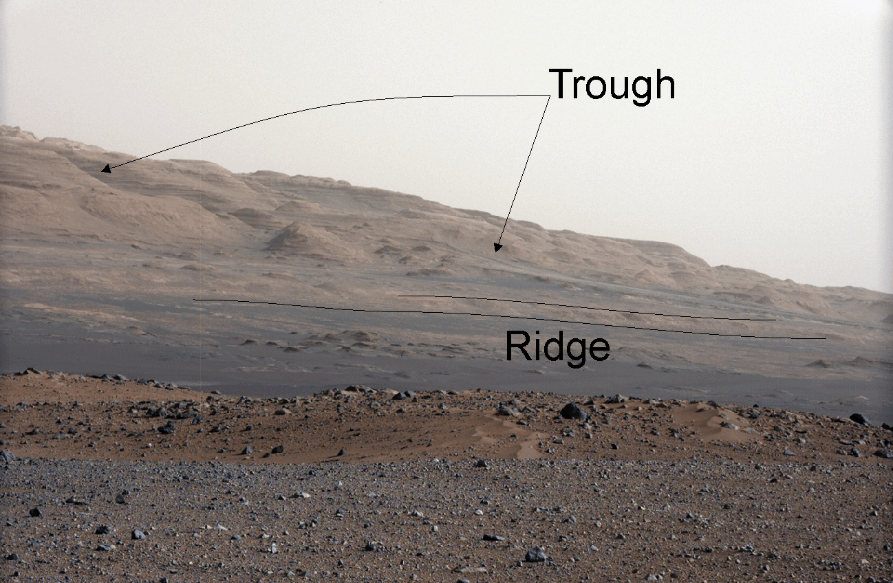
One of those is an area that appears to have formed in water. There’s a low ridge on the bottom of the mountain that likely includes hematite, a mineral that other Mars rovers have found. (Remember the “blueberries” spotted a few years ago?) Hematite is an iron mineral that comes to be “in association with water”, a new study reports, and could point the way to the habitable conditions Curiosity is seeking.
The rub is scientists can’t say for sure how the hematite formed until the rover is practically right next to the ridge. There are plenty of pictures from orbit, but not high-resolution enough for the team to make definitive answers.
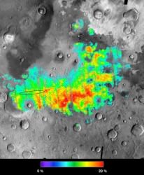
Colors map percentages of hematite in the surface materials in Meridiani Planum on Mars from 5 percent (aqua) to 25 percent (red). Opportunity landed within the black oval. MER scientists say the rocks there had once been drenched in water. Credit: NASA
“Two alternatives are likely: chemical precipitation within the rocks by underground water that became exposed to an oxidizing environment — or weathering by neutral to slightly acidic water,” wrote Arizona State University’s Red Planet Report. Either way, it shows the ridge likely hosted iron oxidation. Earth’s experience with this type of oxidation shows that it happens “almost exclusively” with microorganisms, but that’s not a guarantee on Mars.
Mars Reconnaissance Orbiter images show that the ridge is about 660 feet (200 meters) wide and four miles (6.5 kilometers) long, with strata or layers in the ridge appearing to be similar to those of layers in Mount Sharp.
While Curiosity is not designed to seek life, it can ferret out details of the environment. Just a few weeks ago, for example, it uncovered pebbles that likely formed in the presence of water. Other Mars missions have also found evidence of that liquid, with perhaps some of it once arising from the subsurface. Where the water came from, and why the environment of Mars changed so much in the last few billion years, are ongoing scientific questions.
Gale crater's central peak as it might look under Earthly lighting (NASA/JPL-Caltech/MSSS)
Ahh — there’s nothing like a beautiful sunny day in Gale crater! The rusty sand crunching beneath your wheels, a gentle breeze blowing at a balmy 6º C (43º F), Mount Sharp rising in the distance into a clear blue sky… wait, did I just say blue sky?
I sure did. But no worries — Mars hasn’t sprouted a nitrogen-and-oxygen atmosphere overnight. The image above is a crop from a panoramic mosaic made of images from NASA’s Curiosity rover, showing Gale crater’s central peak Mount Sharp (or Aeolis Mons, if you prefer the official moniker.) Don’t let the blue sky fool you though — the lighting has been adjusted to look like a sunlit scene on Earth, if only to let geologists more easily refer to their own experience when studying the Martian landscape.
Click the image to see the full panorama, and a view of the same scene under more “natural” Martian lighting can be found below:
Aeolis Mons panorama seen in natural lighting (NASA/JPL-Caltech/MSSS)
According to JPL, in both versions the sky has been filled out by extrapolating color and brightness information from the portions of the sky that were captured in images of the terrain.
The elevation of Mt. Sharp compared to three mountains on Earth (NASA/JPL-Caltech/MSSS)
The component images were taken by the 100-millimeter-focal-length telephoto lens camera mounted on the right side of Curiosity’s remote sensing mast, during the 45th Martian day of the rover’s mission on Mars (Sept. 20, 2012).
Informally named after planetary scientist Robert Sharp by the MSL science team, the peak rises rises more than 3 miles (5 kilometers) above the floor of Gale crater.
See more news and images from the Curiosity rover here (and to find out what the latest weather conditions in Gale crater are visit MarsWeather.com here.)
Images from the Curiosity rover on Mars are truly spectacular but a large mosaic from the THEMIS camera aboard NASA’s Mars Odyssey orbiter gives a grand perspective of our new foothold on Mars. Take some time to rove and explore Gale Crater.
The viewer, created using a web-imaging technology from Zoomify, is set to move between points of interest, such as Mars Science Laboratory’s landing site in Aeolis Palus, Glenelg, and Aeolis Mons/Mount Sharp itself. The layered sediments flanking Mount Sharp make it the primary target for Curiosity’s two-year mission. Take control at anytime by clicking on the image. This will stop the automatic roving and leave you in control to explore the terrain of Gale Crater. Use your mouse or the toolbar controls to pan and zoom around the image. You can also use the dropdown in the upper right to take you directly to certain points of interest in the image. Over time, we will add to this interactive feature as more geological points of interest are identified.
THEMIS stands for Thermal Emission Imaging System which is a multiband visible and infrared camera aboard Odyssey. The comprehensive mosaic is pieced together from 205 individual scenes, most taken recently but some dating to 2002 shortly after Odyssey entered Mars orbit in 2001. These images were taken before MSL landed on Mars. Even so, as large as the SUV-sized rover is, it would be too small to see in these images. The smallest details in this image are 18 meters or 60 feet across.
This illustration shows the size of Aoelis Mons (Mount Sharp) in comparison to three large mountains on Earth. The elevation of Mount Sharp is given in kilometers above the floor of Gale Crater. The heights of the Earth mountains are given in kilometers above sea level. Image credit: Tanya Harrison, NASA/JPL-Caltech/MSSS
Gale Crater is 154 kilometers (96 miles) wide. Near the center rises Aeolis Mons, a 5 km (3 mile) high mound of layered sediments, informally dubbed Mount Sharp, after planetary geologist Robert Sharp who died in 2004. Scientists for a time referred to the conical mountain as “The Mound.” The mountain, which would stand among the highest on Earth, cannot be seen from Earth and was unknown before planetary probes visited the Red Planet.
“The reason we decided to assemble such a large, comprehensive mosaic of Gale Crater was to give ourselves a better sense of the context around the landing site, said Jonathon Hill, a Mars research at Arizona State University who assembled the mosaic, a press release. “This will help us to better understand what Curiosity sees and measures as it roves the surface.”
Gale Crater zoom tour created by John Williams (TerraZoom) using Zoomify.
About the author:John Williams is owner of TerraZoom, a Colorado-based web development shop specializing in web mapping and online image zooms. He also writes the award-winning blog, StarryCritters, an interactive site devoted to looking at images from NASA’s Great Observatories and other sources in a different way. A former contributing editor for Final Frontier, his work has appeared in the Planetary Society Blog, Air & Space Smithsonian, Astronomy, Earth, MX Developer’s Journal, The Kansas City Star and many other newspapers and magazines.