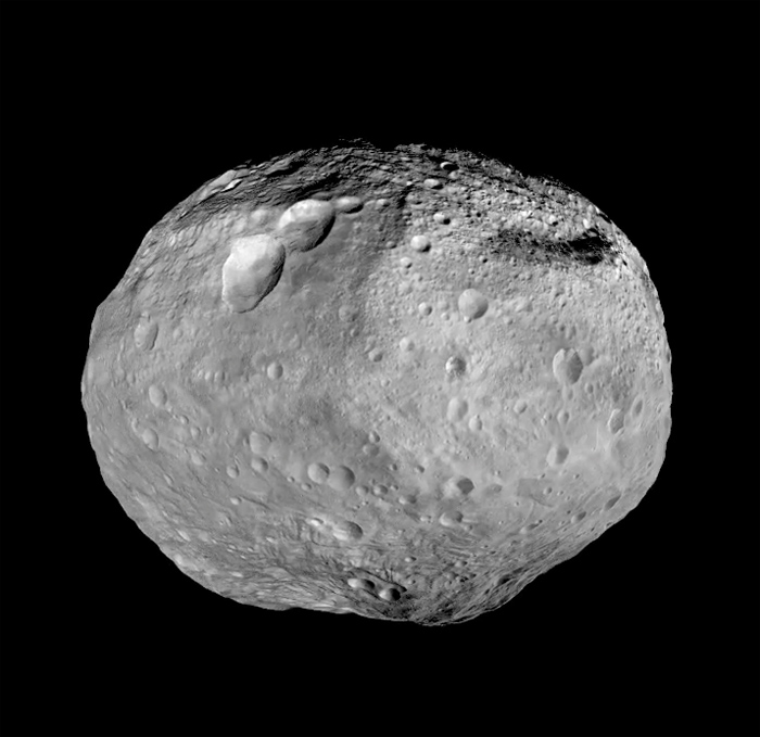
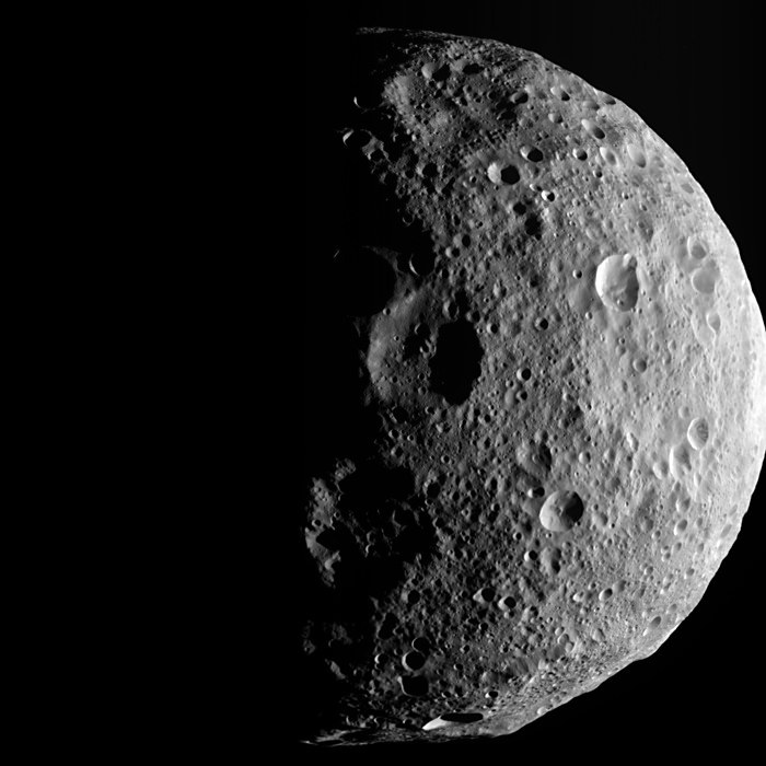
The asteroid Vesta, courtesy of NASA's Dawn spacecraft. Meteorites ejected from Vesta may have helped form Earth's water. Credit: NASA/JPL-Caltech/UCAL/MPS/DLR/IDA
The brave new world of 4 Vesta, courtesy of NASA’s Dawn spacecraft. Credit: NASA/JPL-Caltech/UCAL/MPS/DLR/IDA
Up for a challenge? Planetary action is certainly heating up this summer: Jupiter passed opposition last month, Saturn does so in June, and Mars reaches favorable viewing next month. And with dazzling Venus in the west and Mercury to joining it starting in late June, we’ll soon have all of the naked eye classical planets in the evening sky.
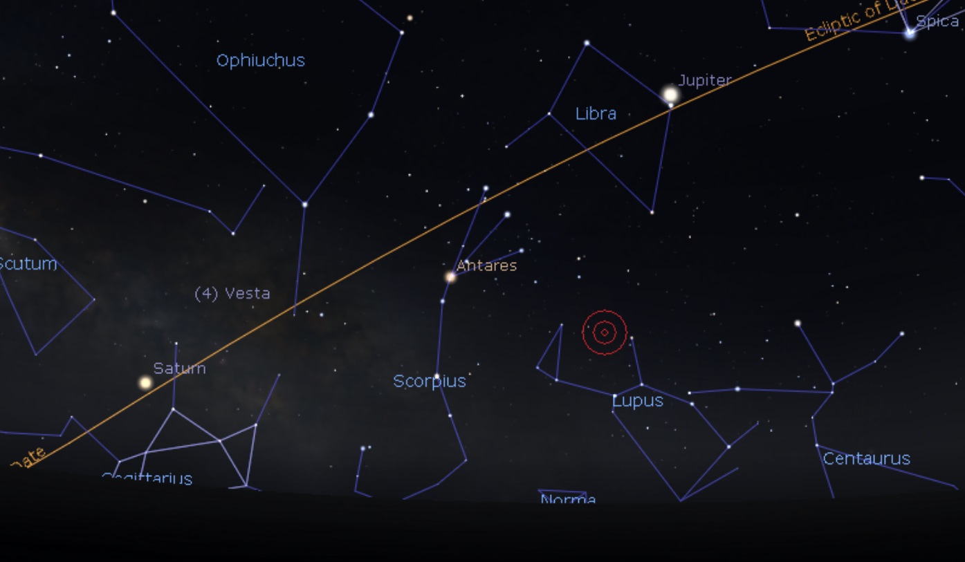
Now, I want to turn your attention towards a potential naked eye object, one you’ve probably never seen: asteroid 4 Vesta.
Vesta and the planet(s)… looking east in early June, about 45 minutes after sunset. Stellarium.
Vistas of Vesta
Vesta reaches opposition in 2018 on the night of June 19th. At 1.14 Astronomical Units (AU, 170.8 million kilometers) distant, this year’s opposition is slightly more favorable than any other since 1989. We won’t get another pass nearly as close until May 2036. Vesta orbits the Sun once every 3.6 years, ranging from a perihelion of 2.15 AU to an aphelion of 2.57 AU.
Although Vesta was the fourth asteroid discovered, it’s actually the brightest, and the only one visible with the naked eye—that is, if you have dark skies, and know exactly where to look for it. This summer, Vesta loiters in the star rich realm of the astronomical constellation Sagittarius, “in the weeds” for viewers up north, but high in the sky for southern viewers.
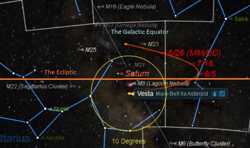
The path of 4 Vesta through mid-September. Credit: Starry Night Education software.
Early June finds Vesta about 5 degrees northwest of the +3.8 magnitude star Mu Sagittarii, threading between the deep sky objects Messier 24 and Messier 25. Vesta then loops westward through the constellation Ophiuchus the Serpent Bearer starting on July 1st, before heading back to Sagittarius on September 5th.
Vesta in 2018
Catching Vesta with the naked eye isn’t easy. You’ll need dark rural skies with a limiting magnitude down to about +5.5, and a good beforehand knowledge of the fixed stars in the region. Vesta also spends 2018 weaving around the star-dappled plane of the Milky Way galaxy, making it an especially challenging target.
Binoculars or a telescope can bring the challenge within reach of suburban and urban skies, making it a pleasure to trace the track of Vesta from night to night. Sketch the background star field and you just might tease out the presence of Vesta as it slowly moves about 30′ arcminutes per night (the diameter of a Full Moon) through June. Crank up the magnification a bit using a large (10 inches aperture or greater) light bucket telescope, and you just might see the faint hint of an oblong disk… 348 by 277 miles (560 by 446 kilometers) in size, Vesta’s apparent size is 0.7” arcseconds around opposition, 1/3 the size of Neptune at its best.
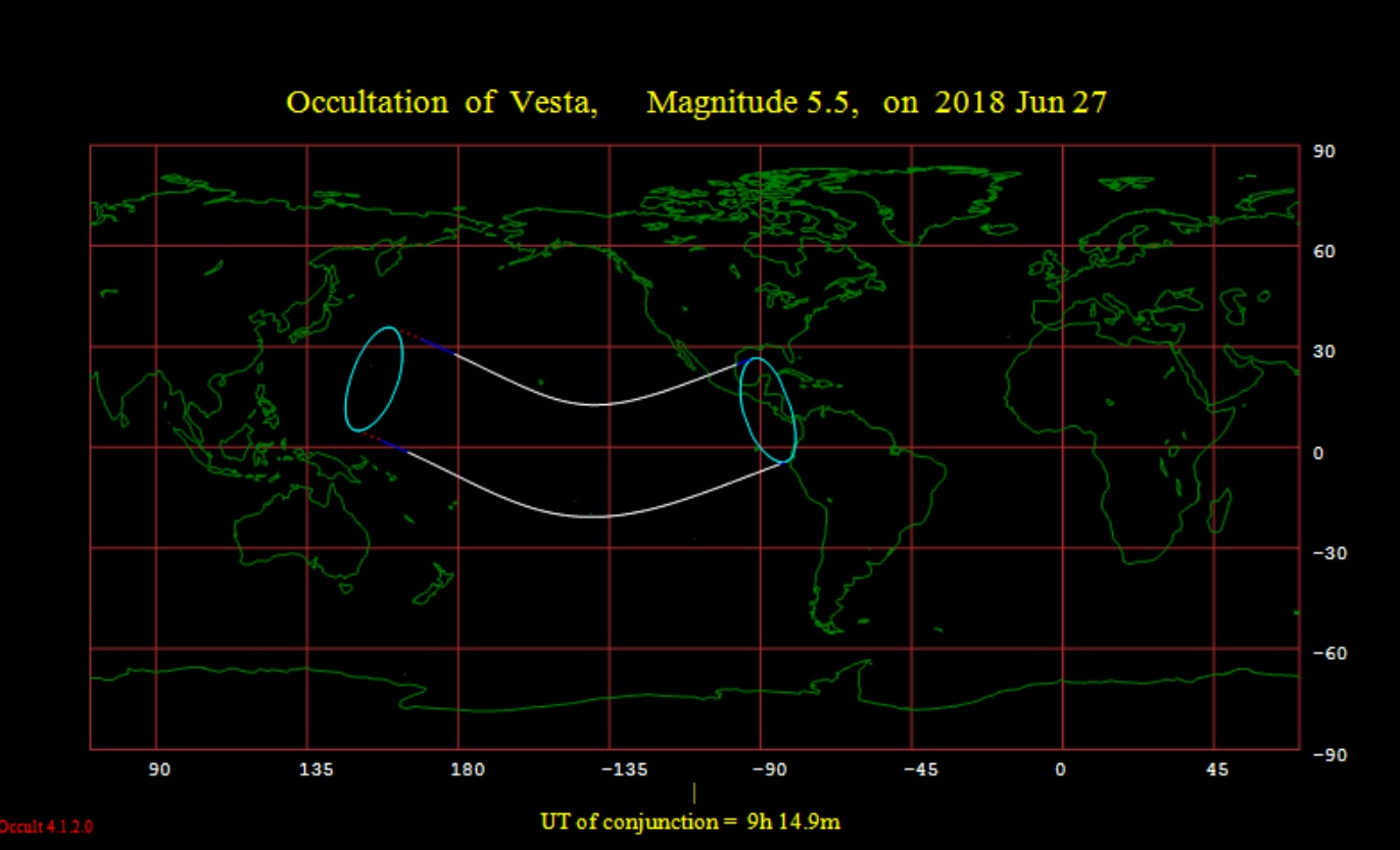
The occultation footprint for the June 27th event. Credit: Occult 4.2 software.
The 99% illuminated, waxing gibbous Moon will actually occult 4 Vesta for Hawaii, Central America and the Galapagos Islands just eight days after opposition on the night of June 27th.
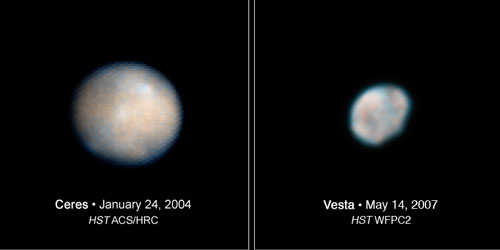
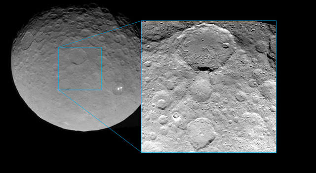
Ceres (left) and Vesta (right) imaged by the Hubble Space Telescope. Credit: NASA/HST/STl
Discovered on the night of March 29th, 1807 by prolific asteroid hunter Heinrich Olber, the Hubble Space Telescope gave us our first blurry images of 4 Vesta back in 2007. NASA’s Dawn spacecraft gave us our first good views of Vesta as a world starting in mid- 2011, orbiting the potato-shaped asteroid for just over a year before departing for 1 Ceres in late 2012.
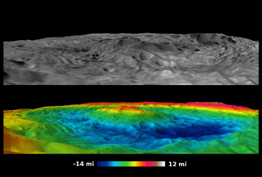
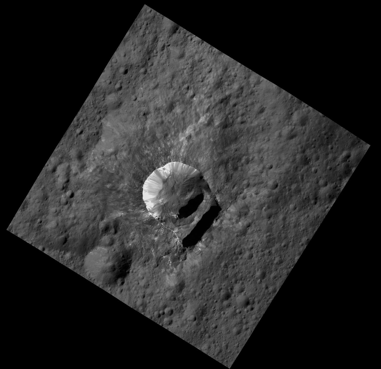
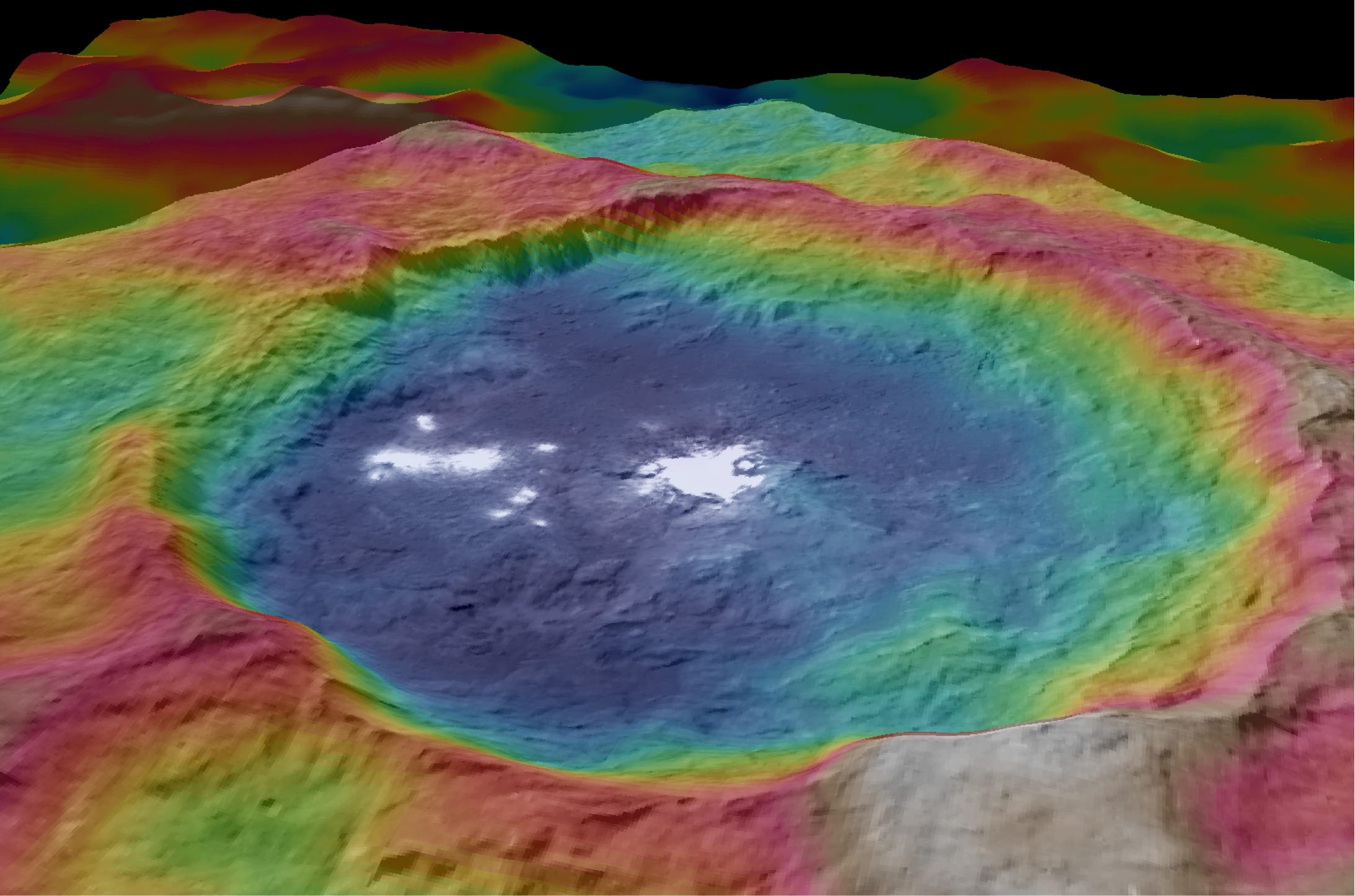
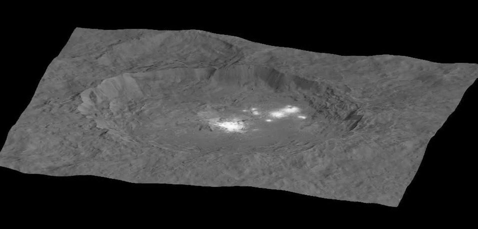
The south pole Rheasilvia impact basin. Based on images obtained by NASA’s Dawn spacecraft, the lower false color map shows the elevation scale scooped out by an ancient impact. Credit: NASA/JPL-Caltech/UCLA/MPS/DLR/IDA/PSI
Attack of the Vestoid(s)
And did you know: we actually have identified samples of Vesta to study, right here on Earth. Vesta sustained a massive impact about a billion years ago, raining debris through the inner solar system. Dawn chronicled the resulting Rheasilvia impact basin on Vesta’s south pole, and asteroids such as 1981 Midas match the spectral composition of Vesta and are collectively known as “Vestoids”.
On Earth, meteorites such as QUE 97053 found in Antarctica and the 1913 Moore County fall in North Carolina also match up in composition to Vesta, and make up a subgroup known as Howardite-Eucrite-Diogenite (HED) meteorites. Collectively, space rocks from this single impact on 4 Vesta contribute to an amazing 5% of all the meteorites recovered on Earth.
Fascinating thoughts to ponder, as we follow the brightest asteroid through the summer sky.
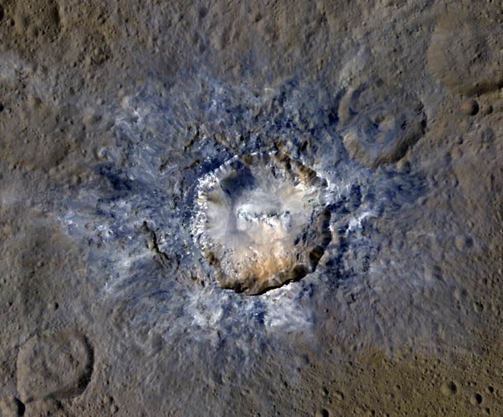
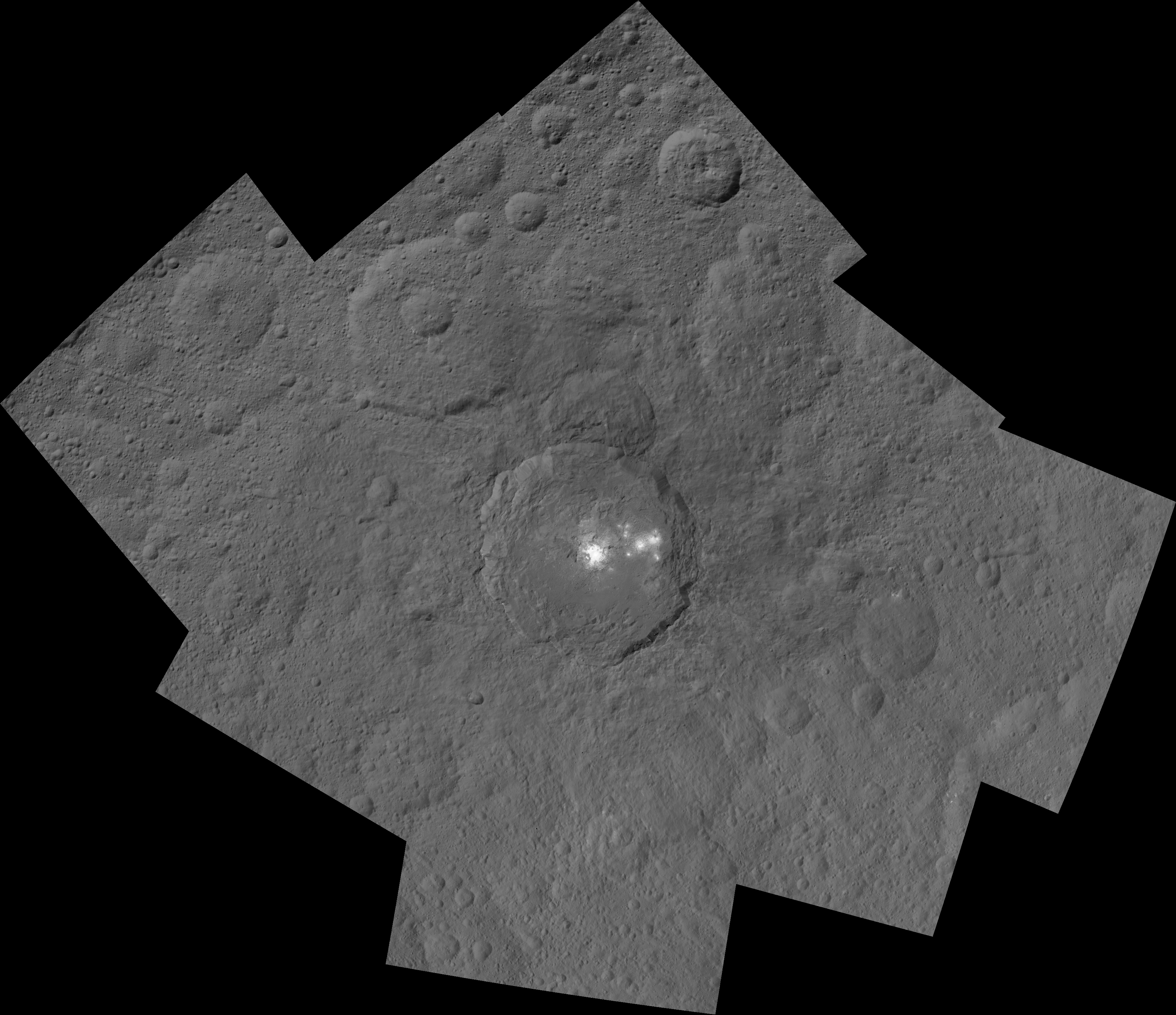
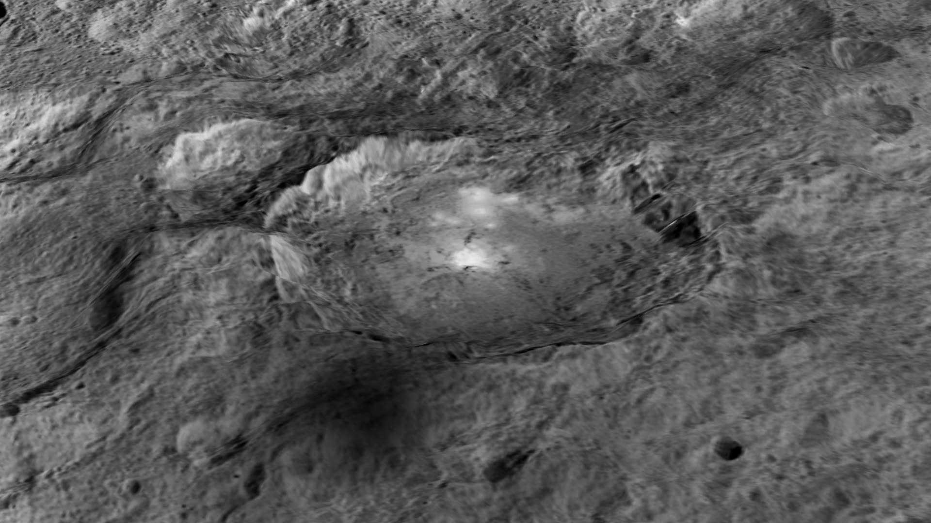
Ceres' Haulani Crater, with a diameter of 21 miles (34 kilometers), shows evidence of landslides from its crater rim. Credits: NASA/JPL-Caltech/UCLA/MPS/DLR/IDA
Ceres’ Haulani Crater, with a diameter of 21 miles (34 kilometers), shows evidence of landslides from its crater rim. Credits: NASA/JPL-Caltech/UCLA/MPS/DLR/IDA
Now in orbit for just over a year at dwarf planet Ceres, NASA’s Dawn spacecraft continues to astound us with new discoveries gleaned from spectral and imagery data captured at ever decreasing orbits as well as since the probe arrived last December at the lowest altitude it will ever reach during the mission.
Mission scientists have just released marvelous new images of Haulani and Oxo craters revealing landslides and mysterious slumps at several of the mysterious bright craters on Ceres – the largest asteroid in the main Asteroid Belt between Mars and Jupiter.
The newly released image of oddly shaped Haulani crater above, shows the crater in enhanced color and reveals evidence of landslides emanating from its crater rim.
“Rays of bluish ejected material are prominent in this image. The color blue in such views has been associated with young features on Ceres,” according to the Dawn science team.
“Enhanced color allows scientists to gain insight into materials and how they relate to surface morphology.”
Look at the image closely and you’ll see its actually polygonal in nature – meaning it resembles a shape made of straight lines – unlike most craters in our solar system which are nearly circular.
”The straight edges of some Cerean craters, including Haulani, result from pre-existing stress patterns and faults beneath the surface,” says the science team.
Haulani Crater has a diameter of 21 miles (34 kilometers) and apparently was formed by an impacting object relatively recently in geologic time and is also one of the brightest areas on Ceres.
“Haulani perfectly displays the properties we would expect from a fresh impact into the surface of Ceres. The crater floor is largely free of impacts, and it contrasts sharply in color from older parts of the surface,” said Martin Hoffmann, co-investigator on the Dawn framing camera team, based at the Max Planck Institute for Solar System Research, Göttingen, Germany, in a statement.
The enhanced color image was created from data gathered at Dawn’s High Altitude Mapping Orbit (HAMO), while orbiting at an altitude of 915 miles (1,470 kilometers) from Ceres.
Data from Dawn’s VIR instrument shows that Haulani’s surface is comprised of different materials than its surroundings.
“False-color images of Haulani show that material excavated by an impact is different than the general surface composition of Ceres. The diversity of materials implies either that there is a mixed layer underneath, or that the impact itself changed the properties of the materials,” said Maria Cristina de Sanctis, the VIR instrument lead scientist, based at the National Institute of Astrophysics, Rome.
Since mid-December, Dawn has been orbiting Ceres in its Low Altitude Mapping Orbit (LAMO), at a distance of 240 miles (385 kilometers) from Ceres, resulting in the most stunning images ever of the dwarf planet.
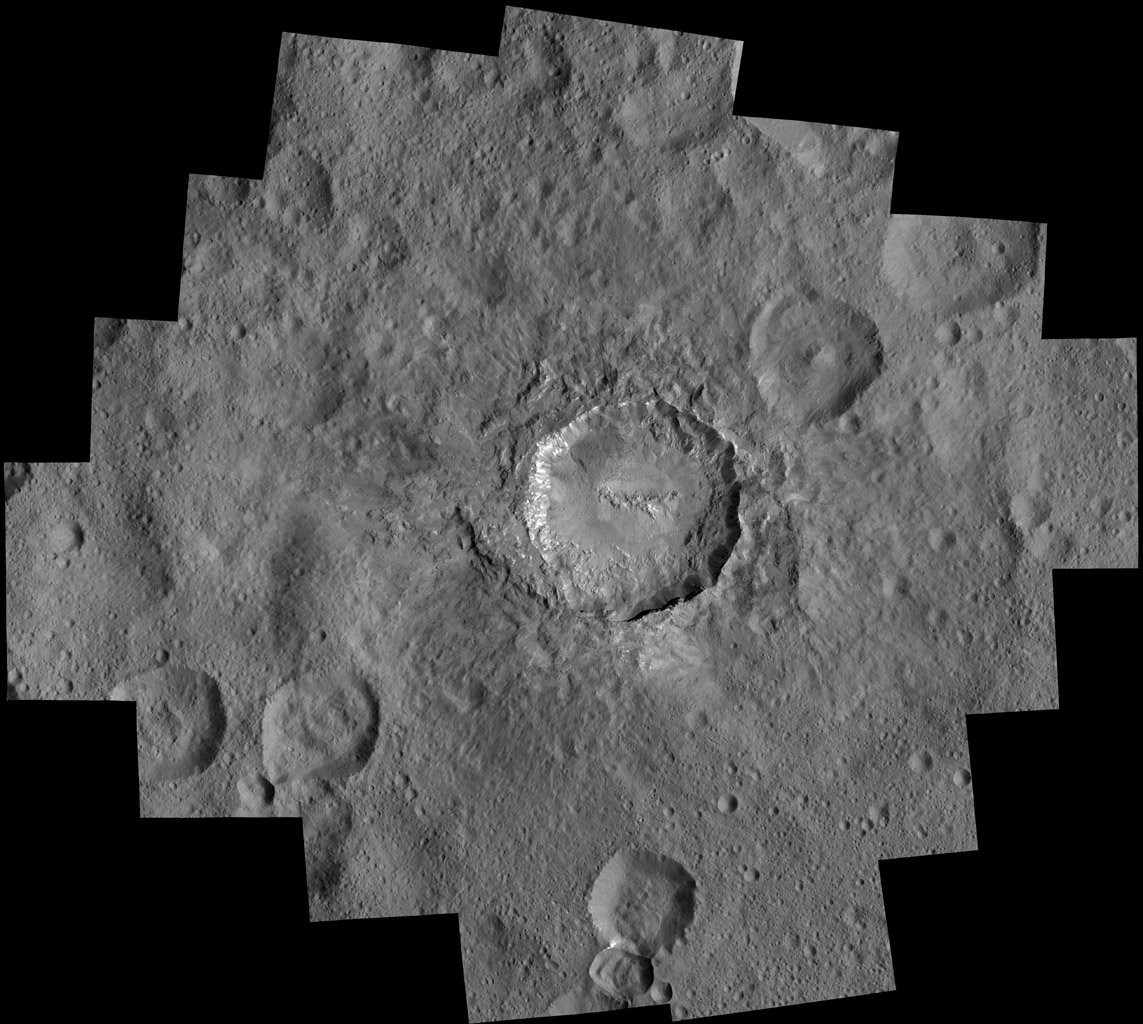
By way of comparison the much higher resolution image of Haulani crater below, is a mosaic of views assembled from multiple images taken from LAMO at less than a third of the HAMO image distance – at only 240 miles (385 kilometers) above Ceres.
Haulani Crater at LAMO. NASA’s Dawn spacecraft took this mosaic view of Haulani Crater at a distance of 240 miles (385 kilometers) from the surface of Ceres. Credits: NASA/JPL-Caltech/UCLA/MPS/DLR/IDA/PSI
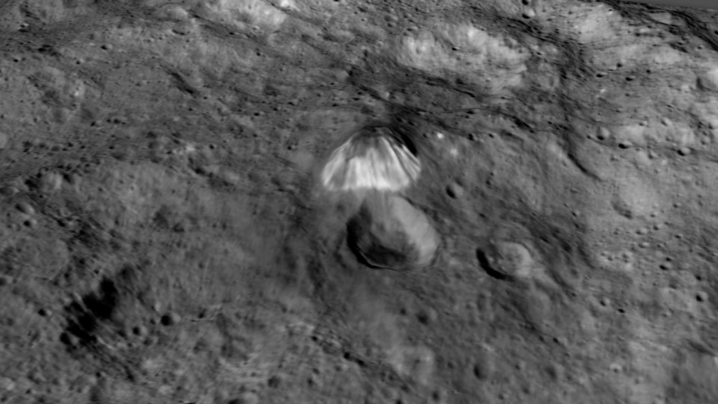
Dawn has also been busy imaging Oxo Crater, which despite its small size of merely 6-mile-wide (10-kilometer-wide) actually counts as a “hidden treasure” on Ceres – because it’s the second-brightest feature on Ceres!
Only the mysterious bright region comprising a multitude of spots inside Occator Crater shine more brightly on Ceres.
Most importantly, Oxo Crater is the only place on Ceres where Dawn has detected water at the surface so far. Via VIR, Dawn data indicate that the water exists either in the form of ice or hydrated minerals. Scientists speculate that the water was exposed either during a landslide or an impact.
“Little Oxo may be poised to make a big contribution to understanding the upper crust of Ceres,” said Chris Russell, principal investigator of the mission, based at the University of California, Los Angeles.
The signatures of minerals detected on the floor of Oxo crater appears to be different from the rest of Ceres.
Furthermore Oxo is “also unique because of the relatively large “slump” in its crater rim, where a mass of material has dropped below the surface.”
Oxo Crater on Ceres is unique because of the relatively large “slump” in its crater rim. The 6-mile-wide (10-kilometer-wide) Oxo crater is the second-brightest feature on Ceres. Credits: NASA/JPL-Caltech/UCLA/MPS/DLR/IDA/PSI
Dawn is Earth’s first probe in human history to explore any dwarf planet, the first to explore Ceres up close and the first to orbit two celestial bodies.
The asteroid Vesta was Dawn’s first orbital target where it conducted extensive observations of the bizarre world for over a year in 2011 and 2012.
The mission is expected to last until at least later into 2016, and possibly longer, depending upon fuel reserves.
Dawn will remain at its current altitude at LAMO for the rest of its mission, and indefinitely afterward, even when no further communications are possible.
Stay tuned here for Ken’s continuing Earth and planetary science and human spaceflight news.
The Moon occults Aldebaran last lunation on March 14th as seen from India. Image credit and copyright: Rajneesh Parashar
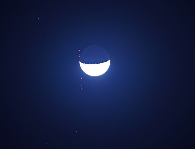
So, did you miss yesterday’s occultation of Venus by the Moon? It was a tough one, to be sure, as the footpath for the event crossed Europe and Asia in the daytime. Watch that Moon, though, as it crosses back into the evening sky later this week, and occults (passes in front of) the bright star Aldebaran for eastern North America and, for Hawaii-based observers, actually covers the brightest of the asteroids, 4 Vesta. Continue reading “Watch the Moon Occult Vesta and Aldebaran This Weekend”
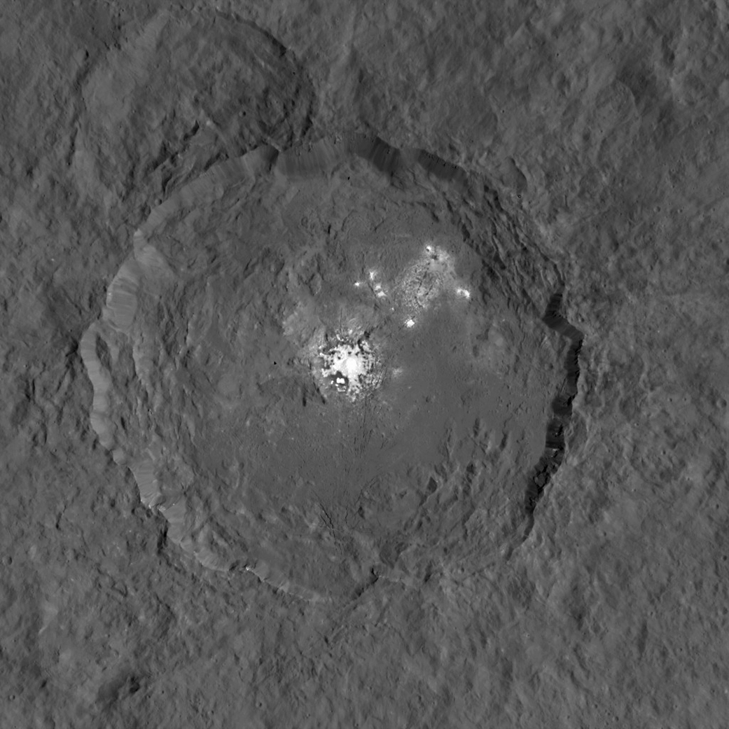
This representation of Ceres' Occator Crater in false colors shows differences in the surface composition. Red corresponds to a wavelength range around 0.97 micrometers (near infrared), green to a wavelength range around 0.75 micrometers (red, visible light) and blue to a wavelength range of around 0.44 micrometers (blue, visible light). Occator measures about 60 miles (90 kilometers) wide. Credits: NASA/JPL-Caltech/UCLA/MPS/DLR/IDA
This representation of Ceres’ Occator Crater in false colors shows differences in the surface composition. Red corresponds to a wavelength range around 0.97 micrometers (near infrared), green to a wavelength range around 0.75 micrometers (red, visible light) and blue to a wavelength range of around 0.44 micrometers (blue, visible light). Occator measures about 60 miles (90 kilometers) wide. Credits: NASA/JPL-Caltech/UCLA/MPS/DLR/IDA
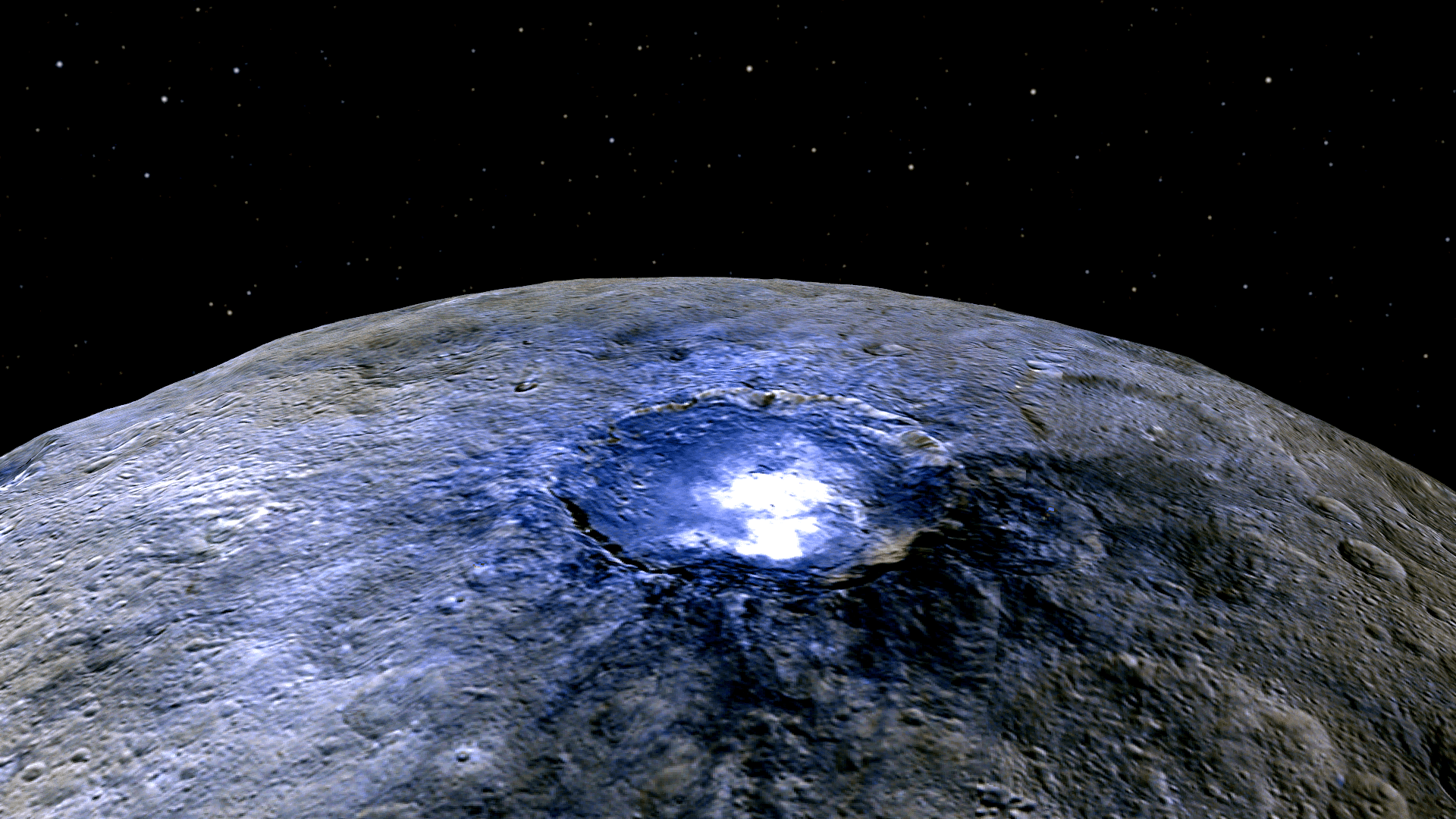
With NASA’s Dawn spacecraft set to enter its final and lowest orbit around the dwarf planet Ceres, spectral measurements are enabling researchers to gradually unravel the nature of the numerous mysterious and intriguing bright spots recently discovered, and now they conclude that briny mixtures of ice and salts apparently reside just beneath certain patches of the pockmarked surface and that “water is sublimating” from the surface of an “active crater”.
This mosaic shows Ceres' Occator crater and surrounding terrain from an altitude of 915 miles (1,470 kilometers), as seen by NASA's Dawn spacecraft. Occator is about 60 miles (90 kilometers) across and 2 miles (4 kilometers) deep. Credits: NASA/JPL-Caltech/UCLA/MPS/DLR/IDA
The most dazzling views ever seen of dwarf planet Ceres and its mysterious bright spots are what’s on tap by year’s end as NASA’s amazing Dawn spacecraft starts a gradual but steep descent over the next two months to its lowest and final orbit around the bizarre icy body.
Engineers at NASA’s Jet Propulsion Laboratory (JPL) successfully fired up the probes exotic ion propulsion system to begin lowering Dawn’s orbital altitude to less than a quarter of what it has been for the past two months of intense mapping operations.
On Oct. 23, Dawn began a seven-week-long dive that uses ion thruster #2 to reduce the spacecrafts vantage point from 915 miles (1,470 kilometers) at the High Altitude Mapping Orbit (HAMO) down to less than 235 miles (380 kilometers) above Ceres at the Low Altitude Mapping Orbit (LAMO).
Dawn is slated to arrive at LAMO by mid-December, just in time to begin delivering the long awaiting Christmas treats.
Ceres has absolutely tantalized researchers far beyond their wildest expectations.
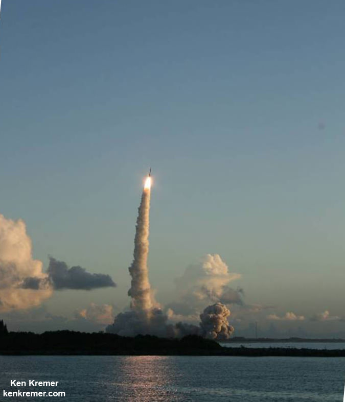
When Dawn arrives at LAMO it will be the culmination of an eight year interplanetary voyage that began with a blastoff on September 27, 2007 by a United Launch Alliance (ULA) Delta II Heavy rocket from Space Launch Complex-17B (SLC-17B) at Cape Canaveral Air Force Station, Florida.
LAMO marks Dawn’s fourth, lowest and final science orbit at Ceres where the highest resolution observations will be gathered and images from the framing camera will achieve a resolution of 120 feet (35 meters) per pixel.
Dawn’s low altitude mapping orbit LAMO. This shows how the orbit naturally shifts slightly (relative to the sun) during the three months of LAMO, starting in blue and ending in red. The spacecraft completes each revolution in 5.5 hours, and Ceres rotates in 9.1 hours, so Dawn will be able to view the entire surface. Credit: NASA/JPL
At LAMO, researchers hope to finally resolve the enduring mystery of the nature of the bright spots that have intrigued science and the general public since they were first glimpsed clearly early this year as Dawn was on its final approach to Ceres.
Dawn arrived in orbit this past spring on March 6, 2015.
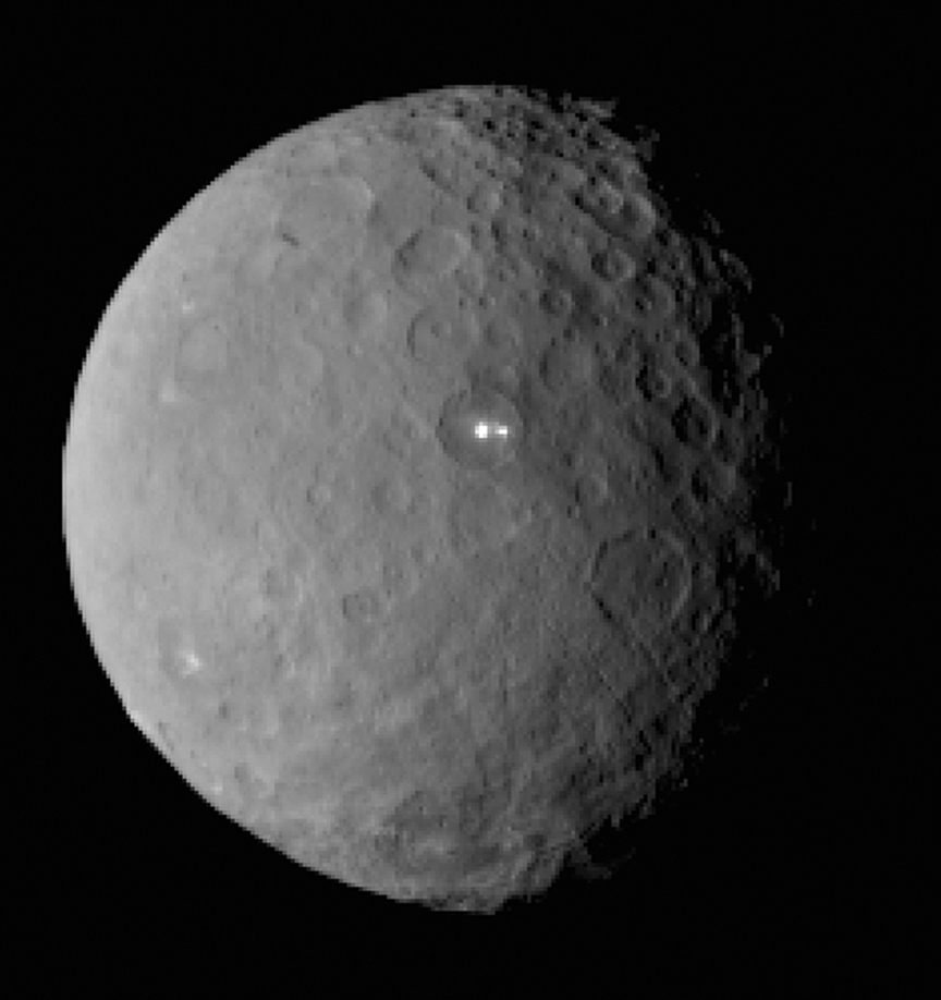
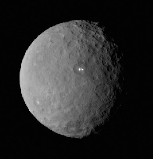
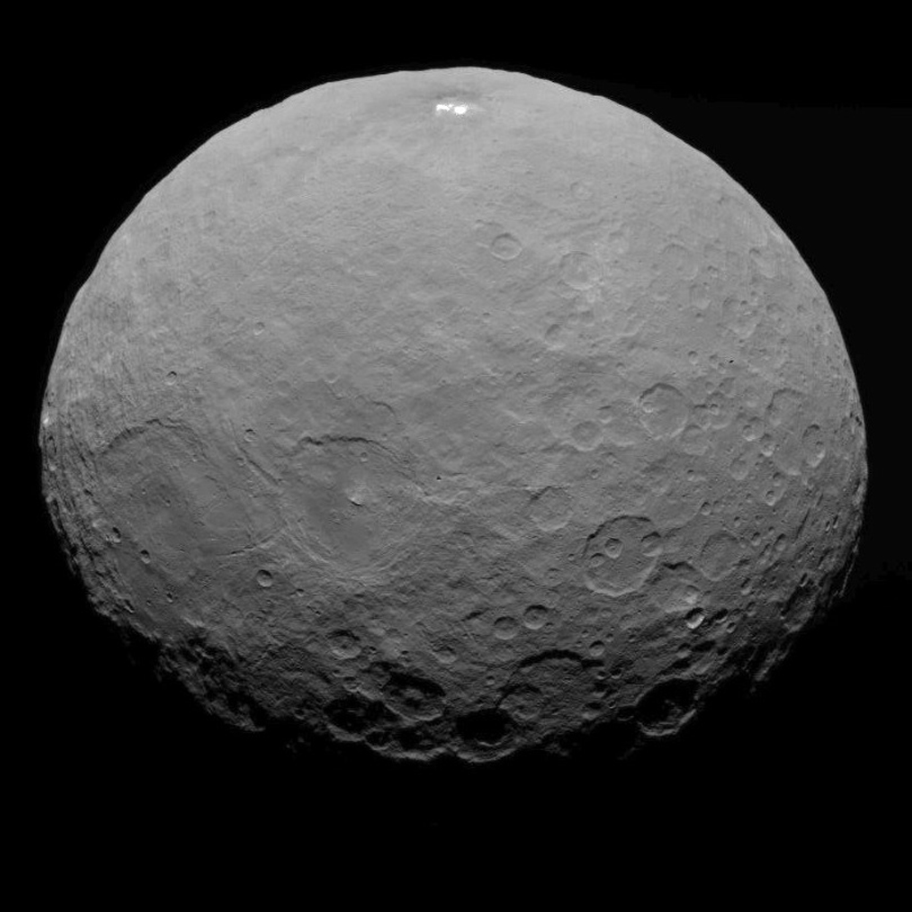
This image was taken by NASA’s Dawn spacecraft of dwarf planet Ceres on Feb. 19 from a distance of nearly 29,000 miles (46,000 km). It shows that the brightest spot on Ceres has a dimmer companion, which apparently lies in the same basin. See below for the wide view. Credit: NASA/JPL-Caltech/UCLA/MPS/DLR/IDA
The science team has just released a new mosaic of the brightest spots on Ceres found at Occator crater and the surrounding terrain – see above.
The images were taken from the HAMO altitude of 915 miles (1,470 kilometers) during the first of six mapping cycles. They have a resolution of 450 feet (140 meters) per pixel.
Occator measures about 60 miles (90 kilometers) across and 2 miles (4 kilometers) deep.
This image, made using images taken by NASA’s Dawn spacecraft during the mission’s High Altitude Mapping Orbit (HAMO) phase, shows Occator crater on Ceres, home to a collection of intriguing bright spots. Credits: NASA/JPL-Caltech/UCLA/MPS/DLR/IDA
Because the spots are so bright they are generally overexposed. Therefore the team took two sets of images, with shorter and longer exposure times, to maximize the details of the interior of Occator.
“This view uses a composite of two images of Occator: one using a short exposure that captures the detail in the bright spots, and one where the background surface is captured at normal exposure.”
The bright spots at Occator crater remain the biggest Cerean mystery.
So far the imagery and other science data may point to evaporation of salty water from the interior as the source of the bright spots.
“Occasional water leakage on to the surface could leave salt there as the water would sublime,” Prof. Chris Russell, Dawn principal investigator told Universe Today exclusively.
“The big picture that is emerging is that Ceres fills a unique niche.”
“Ceres fills a unique niche between the cold icy bodies of the outer solar system, with their rock hard icy surfaces, and the water planets Mars and Earth that can support ice and water on their surfaces,” Russell, of the University of California, Los Angeles, told me.
Dawn has peeled back Ceres secrets as the spacecraft orbits lower and lower. Detailed measurements gathered to date have yielded global mineral and topographic maps from HAMO with the best resolution ever as the science team painstakingly stitched together the probes spectral and imaging products.
And the best is yet to come at LAMO.
At HAMO, Dawn’ instruments, including the Framing Camera and Visible and Infrared Spectrometer (VIR) were aimed at slightly different angles in each mapping cycle allowing the team to generate stereo views and construct 3-D maps.
“The emphasis during HAMO is to get good stereo data on the elevations of the surface topography and to get good high resolution clear and color data with the framing camera,” Russell explained.
This view from NASA’s Dawn spacecraft is a color-coded topographic map of Occator crater on Ceres. Blue is the lowest elevation, and brown is the highest. The crater, which is home to the brightest spots on Ceres, is approximately 56 miles (90 kilometers wide). Credits: NASA/JPL-Caltech/UCLA/MPS/DLR/IDA
Dawn is Earth’s first probe in human history to explore any dwarf planet, the first to explore Ceres up close and the first to orbit two celestial bodies.
The asteroid Vesta was Dawn’s first orbital target where it conducted extensive observations of the bizarre world for over a year in 2011 and 2012.
Ceres is a Texas-sized world, ranks as the largest object in the main asteroid belt between Mars and Jupiter, and may have a subsurface ocean of liquid water that could be hospitable to life.
This map-projected view of Ceres was created from images taken by NASA’s Dawn spacecraft during its high-altitude mapping orbit, in August and September, 2015. This color coded map can provide valuable insights into the mineral composition of the surface, as well as the relative ages of surface features. Credits: NASA/JPL-Caltech/UCLA/MPS/DLR/IDA
The mission is expected to last until at least March 2016, and possibly longer, depending upon fuel reserves.
“It will end some time between March and December,” Dr. Marc Rayman, Dawn’s chief engineer and mission director based at NASA’s Jet Propulsion Laboratory, Pasadena, California, told Universe Today.
Stay tuned here for Ken’s continuing Earth and planetary science and human spaceflight news.
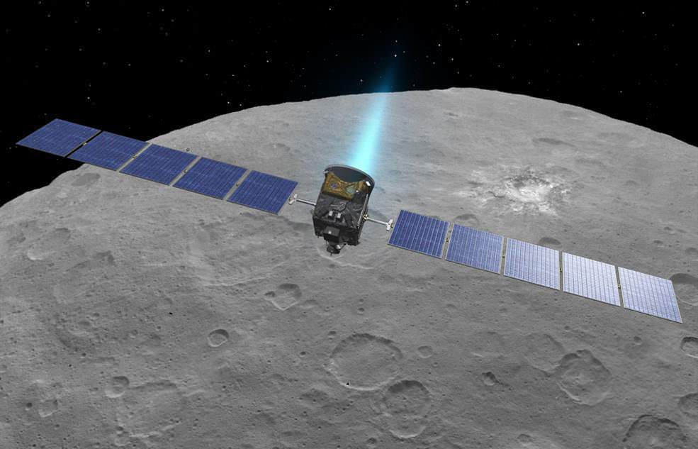
An artist’s conception shows NASA’s Dawn spacecraft flying above Ceres. This view incorporates actual imagery from the Dawn mission. Credit: NASA/JPL-Caltech/UCLA/MPS/DLR/IDA
This map-projected view of Ceres was created from images taken by NASA's Dawn spacecraft during its high-altitude mapping orbit, in August and September, 2015. This color coded map can provide valuable insights into the mineral composition of the surface, as well as the relative ages of surface features. Credits: NASA/JPL-Caltech/UCLA/MPS/DLR/IDA
Slowly but surely the mysteries of dwarf planet Ceres are being peeled back layer by layer as NASA’s Dawn spacecraft orbits lower and lower and gathers detailed measurements that have now yielded global mineral and topographic maps, tantalizing researchers with the best resolution ever.
The Dawn science team has been painstakingly stitching together the spectral and imaging products captured from the lowest orbit yet achieved into high resolution global maps of Ceres, released today Sept. 30, by NASA.
“Ceres continues to amaze, yet puzzle us, as we examine our multitude of images, spectra and now energetic particle bursts,” said Chris Russell, Dawn principal investigator at the University of California, Los Angeles, in a statement.
The color coded map above is providing researchers with valuable insights into the mineral composition of Ceres surface, as well as the relative ages of the surface features that were a near total mystery until Dawn arrived on March 6, 2015.
The false-color mineral map view combines images taken using infrared (920 nanometers), red (750 nanometers) and blue (440 nanometers) spectral filters.
“Redder colors indicate places on Ceres’ surface that reflect light strongly in the infrared, while bluish colors indicate enhanced reflectivity at short (bluer) wavelengths; green indicates places where albedo, or overall brightness, is strongly enhanced,” say officials.
“Scientists use this technique in order to highlight subtle color differences across Ceres, which would appear fairly uniform in natural color. This can provide valuable insights into the mineral composition of the surface, as well as the relative ages of surface features.”
Researchers say the mineral variations at Ceres “are more subtle than on Vesta, Dawn’s previous port of call.”
The asteroid Vesta was Dawn’s first orbital target and conducted extensive observations of the bizarre world for over a year in 2011 and 2012.
The Dawn team is meeting this week to review and publish the mission results so far at the European Planetary Science Conference in Nantes, France.
Dawn is Earth’s first probe in human history to explore any dwarf planet, the first to explore Ceres up close and the first to orbit two celestial bodies.
Ceres is a Texas-sized world, ranks as the largest object in the main asteroid belt between Mars and Jupiter, and may have a subsurface ocean of liquid water that could be hospitable to life.
This view from NASA’s Dawn spacecraft is a color-coded topographic map of Occator crater on Ceres. Blue is the lowest elevation, and brown is the highest. The crater, which is home to the brightest spots on Ceres, is approximately 56 miles (90 kilometers wide). Credits: NASA/JPL-Caltech/UCLA/MPS/DLR/IDA
The newly released maps were created from data gathered at Dawn’s current science orbit, known as the High Altitude Mapping Orbit (HAMO) phase of the mission, during August and September.
At HAMO, Dawn is circling Ceres at an altitude of barely 915 miles (1,470 kilometers) above the heavily cratered surface.
“Dawn arrived in this third mapping orbit [HAMO] on Aug. 13. It began this third mapping phase on schedule on Aug. 17,” Dr. Marc Rayman, Dawn’s chief engineer and mission director based at NASA’s Jet Propulsion Laboratory, Pasadena, California, told Universe Today.
Each HAMO mapping orbit cycle lasts 11 days and consists of 14 orbits lasting 19 hours each. Ceres is entirely mapped during each of the 6 cycles. The third mapping cycle started on Sept. 9.
Dawn’ instruments, including the Framing Camera and Visible and Infrared Spectrometer (VIR) will be aimed at slightly different angles in each mapping cycle allowing the team to generate stereo views and construct 3-D maps.
“The emphasis during HAMO is to get good stereo data on the elevations of the surface topography and to get good high resolution clear and color data with the framing camera,” Russell told me.
“We are hoping to get lots of VIR IR data to help understand the composition of the surface better.”
“Dawn will use the color filters in its framing camera to record the sights in visible and infrared wavelengths,” notes Rayman.
The new maps at HAMO provide about three times better resolution than the images captured from its previous orbit in June, and nearly 10 times better than in the spacecraft’s initial orbit at Ceres in April and May.
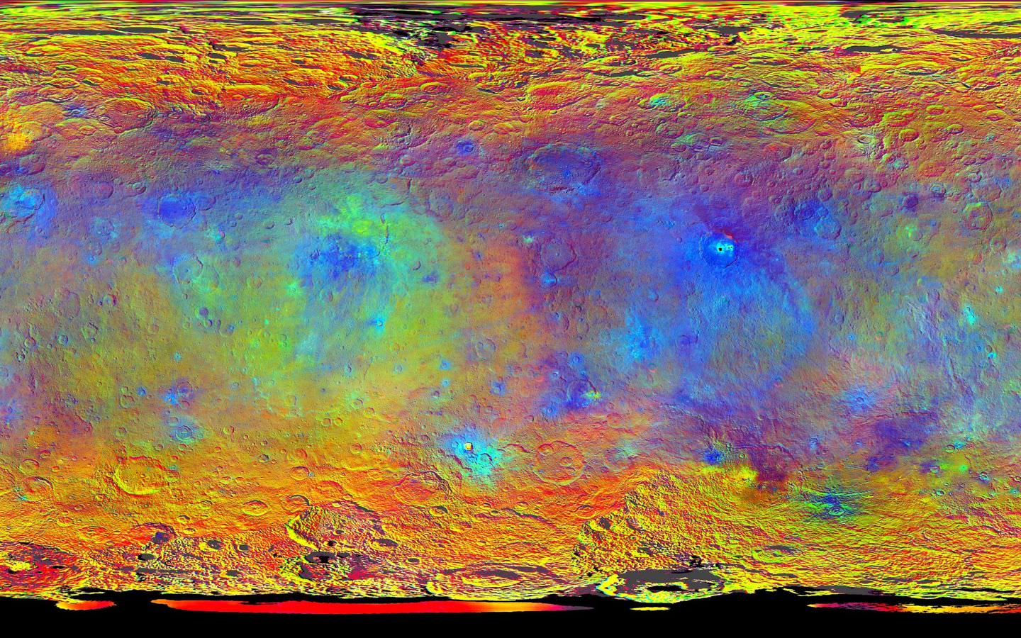
This color-coded map from NASA’s Dawn shows the highs and lows of topography on the surface of dwarf planet Ceres. It is labeled with names of features approved by the International Astronomical Union. The color scale extends about 5 miles (7.5 kilometers) below the reference surface in indigo to 5 miles (7.5 kilometers) above the reference surface in white. Credits: NASA/JPL-Caltech/UCLA/MPS/DLR/IDA
The science team also released a new color-coded topographic map annotated with over a dozen Cerean feature names recently approved by the IAU.
“The names for features on Ceres are all eponymous for agricultural spirits, deities and festivals from cultures around the world. These include Jaja, after the Abkhazian harvest goddess, and Ernutet, after the cobra-headed Egyptian harvest goddess. A 12-mile (20-kilometer) diameter mountain near Ceres’ north pole is now called Ysolo Mons, for an Albanian festival that marks the first day of the eggplant harvest.”
The biggest Cerean mystery of all remains the nature of the bright spots at Occator crater. It’s still under analysis and the team released a new color coded topographic map.
The imagery and other science data may point to evaporation of salty water as the source of the bright spots.
“Occasional water leakage on to the surface could leave salt there as the water would sublime,” Russell told me.
“The big picture that is emerging is that Ceres fills a unique niche,” Prof. Chris Russell, Dawn principal investigator told Universe Today exclusively.
“Ceres fills a unique niche between the cold icy bodies of the outer solar system, with their rock hard icy surfaces, and the water planets Mars and Earth that can support ice and water on their surfaces,” said Russell.
“The irregular shapes of craters on Ceres are especially interesting, resembling craters we see on Saturn’s icy moon Rhea,” says Carol Raymond, Dawn’s deputy principal investigator based at NASA’s Jet Propulsion Laboratory, Pasadena, California. “They are very different from the bowl-shaped craters on Vesta.”
This image was taken by NASA’s Dawn spacecraft of dwarf planet Ceres on Feb. 19 from a distance of nearly 29,000 miles (46,000 km). It shows that the brightest spot on Ceres has a dimmer companion, which apparently lies in the same basin. See below for the wide view. Credit: NASA/JPL-Caltech/UCLA/MPS/DLR/IDA
Dawn was launched on September 27, 2007 by a United Launch Alliance (ULA) Delta II Heavy rocket from Space Launch Complex-17B (SLC-17B) at Cape Canaveral Air Force Station, Florida.
Stay tuned here for Ken’s continuing Earth and planetary science and human spaceflight news.
This image, made using images taken by NASA’s Dawn spacecraft during the mission’s High Altitude Mapping Orbit (HAMO) phase, shows Occator crater on Ceres, home to a collection of intriguing bright spots. Credits: NASA/JPL-Caltech/UCLA/MPS/DLR/IDA
This image, made using images taken by NASA's Dawn spacecraft during the mission's High Altitude Mapping Orbit (HAMO) phase, shows Occator crater on Ceres, home to a collection of intriguing bright spots. Credits: NASA/JPL-Caltech/UCLA/MPS/DLR/IDA
This image, made using images taken by NASA’s Dawn spacecraft during the mission’s High Altitude Mapping Orbit (HAMO) phase, shows Occator crater on Ceres, home to a collection of intriguing bright spots. Credits: NASA/JPL-Caltech/UCLA/MPS/DLR/IDA
Story/imagery updated[/caption]
Since scientists believe that Ceres occupies a “unique niche” in the solar system and apparently harbors subsurface ice or liquid oceans, could the bright spots arise from subsurface “water leakage?” To find out Universe Today asked Dawn’s Principal Investigator and Chief Engineer.
“The big picture that is emerging is that Ceres fills a unique niche,” Prof. Chris Russell, Dawn principal investigator told Universe Today exclusively.
“Ceres fills a unique niche between the cold icy bodies of the outer solar system, with their rock hard icy surfaces, and the water planets Mars and Earth that can support ice and water on their surfaces,” said Russell, of the University of California, Los Angeles.
And with Dawn recently arrived at its second lowest science mapping orbit of the planned mission around icy dwarf planet Ceres in mid-August, the NASA spacecraft is capturing the most stunningly detailed images yet of those ever intriguing bright spots located inside Occator crater.
The imagery and other science data may point to evaporation of salty water as the source of the bright spots.
“Occasional water leakage on to the surface could leave salt there as the water would sublime,” Russell told me.
Circling the Lights of Occator crater on Ceres. This image, made using images taken by NASA’s Dawn spacecraft during the mission’s High Altitude Mapping Orbit (HAMO) phase and draped over a shape model, shows Occator crater on Ceres, home to a collection of intriguing bright spots. The image has been stretched by 1.5 times in the vertical direction to better illustrate the crater’s topography. Credits: NASA/JPL-Caltech/UCLA/MPS/DLR/IDA
Dawn is Earth’s first probe to explore any dwarf planet and the first to explore Ceres up close. It was built by Orbital ATK.
To shed more light on what still remains rather mysterious even today, NASA has just released the best yet imagery, which was taken at Dawn’s High Altitude Mapping Orbit (HAMO) phase and they raise as many questions as they answer.
Occator has captured popular fascination world-wide because the 60 miles (90 kilometers) diameter crater is rife with the alien bodies brightest spots and whose nature remains elusive to this day, over half a year after Dawn arrived in orbit this past spring on March 6, 2015.
The new imagery from Dawn’s current HAMO mapping orbit was taken at an altitude of just 915 miles (1,470 kilometers). They provide about three times better resolution than the images captured from its previous orbit in June, and nearly 10 times better than in the spacecraft’s initial orbit at Ceres in April and May, says the team.
So with the new HAMO orbit images in hand, I asked the team what’s the latest thinking on the bright spots nature?
Initially a lot of speculation focused on water ice. But the scientists opinions have changed substantially as the data pours in from the lower orbits and forced new thinking on alternative hypotheses – to the absolute delight of the entire team!
“When the spots appeared at first to have an albedo approaching 100%, we were forced to think about the possibility of [water] ice being on the surface,” Russell explained.
“However the survey data revealed that the bright spots were only reflecting about 50% of the incoming light.”
“We did not like the ice hypothesis because ice sublimes under the conditions on Ceres surface. So we were quite relieved by the lower albedo.”
“So what could be 50% reflective? If we look at Earth we find that when water evaporates on the desert it leaves salt which is reflective. We know from its density that water or ice is inside Ceres.”
“So the occasional water leakage on to the surface could leave salt there as the water would sublime even faster than ice.”
At this time no one knows how deep the potential ice deposit or water reservoir sources of the “water leakage” reside beneath the surface, or whether the bright salt spots arose from past or current activity and perhaps get replenished or enlarged over time. To date there is no evidence showing plumes currently erupting from the Cerean surface.
Video Caption: Circling Occator Crater on Ceres. This animation, made using data from NASA’s Dawn spacecraft, shows the topography of Occator crater on Ceres. Credits: Credit: NASA/JPL-Caltech/UCLA/MPS/DLR/IDA/PSI
Dawn is an international science mission and equipped with a trio of state of the art science instruments from Germany, Italy and the US. They will elucidate the overall elemental and chemical composition and nature of Ceres, its bright spots and other wondrous geological features like the pyramidal mountain object.
I asked the PI and Chief Engineer to explain specifically how and which of the instruments is the team using right now at HAMO to determine the bright spots composition?
“The instruments that will reveal the composition of the spots are the framing camera [from Germany], the infrared spectrometer, and the visible spectrometer [both from the VIR instrument from Italy], replied Dr. Marc Rayman, Dawn’s chief engineer and mission director based at NASA’s Jet Propulsion Laboratory, Pasadena, California.
“Dawn arrived in this third mapping orbit [HAMO] on Aug. 13. It began this third mapping phase on schedule on Aug. 17.”
But much work remains to gather and interpret the data and discern the identity of which salts are actually present on Ceres.
“While salts of various sorts have the right reflectance, they are hard to distinguish from one another in the visible,” Russell elaborated to Universe Today.
“That is one reason VIR is working extra hard on the IR spectrum. Scientists are beginning to speculate on the salts. And to think about what salts could be formed in the interior.”
“That is at an early stage right now,” Russell stated.
“I know of nothing exactly like these spots anywhere. We are excited about these scientific surprises!”
Occator crater lies in Ceres northern hemisphere.
“There are other lines of investigation besides direct compositional measurement that will provide insight into the spots, including the geological context,” Rayman told Universe Today.
Each of Dawn’s two framing cameras is also outfitted with a wheel of 7 color filters, explained Joe Makowski, Dawn program manager from Orbital ATK, in an interview.
Different spectral data is gathered using the different filters which can be varied during each orbit.
“So far Dawn has completed 2 mapping orbit cycles of the 6 cycles planned at HAMO.”
Each HAMO mapping orbit cycle lasts 11 days and consists of 14 orbits lasting 19 hours each. Ceres is entirely mapped during each of the 6 cycles. The third mapping cycle just started on Wednesday, Sept. 9.
The instruments will be aimed at slightly different angle in each mapping cycle allowing the team to generate stereo views and construct 3-D maps.
“The emphasis during HAMO is to get good stereo data on the elevations of the surface topography and to get good high resolution clear and color data with the framing camera,” Russell explained.
“We are hoping to get lots of VIR IR data to help understand the composition of the surface better.”
“Dawn will use the color filters in its framing camera to record the sights in visible and infrared wavelengths,” notes Rayman.
“Dawn remains at HAMO until October 23. Then it begins thrusting with the ion propulsion thrusters to reach its lowest mapping orbit named LAMO [Low Altitude Mapping Orbit],” Makowski told me.
“Dawn will arrive at LAMO on December 15, 2015.”
That’s a Christmas present we can all look forward to with glee!
This image was taken by NASA’s Dawn spacecraft of dwarf planet Ceres on Feb. 19 from a distance of nearly 29,000 miles (46,000 kilometers). It shows that the brightest spot on Ceres has a dimmer companion, which apparently lies in the same basin. Image Credit: NASA/JPL-Caltech/UCLA/MPS/DLR/IDA
What is the teams reaction, interplay and interpretation regarding the mountains of new data being received from Dawn? How do the geologic processes compare to Earth?
“Dawn has transformed what was so recently a few bright dots into a complex and beautiful, gleaming landscape,” says Rayman. “Soon, the scientific analysis will reveal the geological and chemical nature of this mysterious and mesmerizing extraterrestrial scenery.”
“We do believe we see geologic processes analogous to those on Earth – but with important Cerean twists,” Russell told me.
“However we are at a point in the mission where conservative scientists are interpreting what we see in terms of familiar processes. And the free thinkers are imagining wild scenarios for what they see.”
“The next few weeks (months?) will be a time where the team argues amongst themselves and finds the proper compromise between tradition and innovation,” Russell concluded elegantly.
Among the highest features seen on Ceres so far is a mountain about 4 miles (6 kilometers) high, which is roughly the elevation of Mount McKinley in Alaska’s Denali National Park. Vertical relief has been exaggerated by a factor of five to help understand the topography. Credits: NASA/JPL-Caltech/UCLA/MPS/DLR/IDA/LPI
A batch of new results from Dawn at Ceres are expected to be released during science presentations at the European Planetary Science Congress 2015 being held in Nantes, France from 27 September to 2 October 2015.
The Dawn mission is expected to last until at least March 2016, and possibly longer, depending upon fuel reserves.
“It will end some time between March and December,” Rayman told me.
The science objectives in the LAMO orbit could be achieved as soon as March. But the team wants to extend operations as long as possible, perhaps to June or beyond, if the spacecraft remains healthy and has sufficient hydrazine maneuvering fuel and NASA funding to operate.
“We expect Dawn to complete the mission objectives at Ceres by March 2016. June is a the programmatic milestone for end of the nominal mission, effectively a time margin,” Makowski told Universe Today.
“The team is working to a well-defined exploration plan for Ceres, which we expect to accomplish by March, if all goes well.”
“At launch Dawn started with 45 kg of hydrazine. It has about 21 kg of usable hydrazine onboard as of today.”
“We expect to use about 15 kg during the nominal remaining mission,” Makowski stated.
Therefore Dawn may have roughly 5 kg or so of hydrazine fuel for any extended mission, if all goes well, that may eventually be approved by NASA. Of course NASA’s budget depends also on what is approved by the US Congress.
The intriguing brightest spots on Ceres lie in a crater named Occator, which is about 60 miles (90 kilometers) across and 2 miles (4 kilometers) deep. Vertical relief has been exaggerated by a factor of five. Exaggerating the relief helps scientists understand and visualize the topography much more easily, and highlights features that are sometimes subtle. Credits: NASA/JPL-Caltech/UCLA/MPS/DLR/IDA/LPI
Dawn was launched on September 27, 2007 by a United Launch Alliance (ULA) Delta II Heavy rocket from Space Launch Complex-17B (SLC-17B) at Cape Canaveral Air Force Station, Florida.
Stay tuned here for Ken’s continuing Earth and planetary science and human spaceflight news.
Dawn launch on September 27, 2007 by a United Launch Alliance Delta II Heavy rocket from Cape Canaveral Air Force Station, Florida. Credit: Ken Kremer/kenkremer.com
This image of Ceres was taken by NASA's Dawn spacecraft on May 7, 2015, from a distance of 8,400 miles (13,600 kilometers). Credit: NASA/JPL-Caltech/UCLA/MPS/DLR/IDA
Video caption: This new video animation of Ceres was created from images taken by NASA’s Dawn spacecraft at altitudes of 8,400 miles (13,600 kilometers) and 3,200 miles (5,100 kilometers) away. Vertical dimension has been exaggerated by a factor of two and a star field added. Credit: NASA/JPL-Caltech/UCLA/MPS/DLR/IDA
Scientists leading NASA’s Dawn mission to dwarf planet Ceres have just released a brand new animated video showing a dramatic fly over of the heavily cratered world featuring its mysterious bright spots whose exact origin and nature remain elusive.
Meanwhile, the venerable probe has just successfully entered its new and lower mapping orbit on June 3 from which researchers hope to glean hordes of new data to unravel the secrets of the bright spots and unlock the nature of Ceres origin and evolution.
Pockmarked Ceres is an alien world unlike any other in our solar system.
“Dawn completed the maneuvering to reach its second mapping orbit and stopped ion-thrusting on schedule. Since May 9, the spacecraft has reduced its orbital altitude from 8,400 miles (13,600 kilometers) to 2,700 miles (4,400 kilometers),” reported Marc Rayman, Dawn Chief Engineer/ Mission Director of NASA’s Jet Propulsion Laboratory, Pasadena, California.
“As Dawn flew 2,700 miles (4,400 kilometers) over Ceres’ north pole on June 5 that marked the beginning of the new mapping phase, and Dawn began taking photos and making other measurements on schedule.”
Each orbit of Dawn around Ceres at this second science mapping orbit lasts 3.1 days.
The new video was created by the research team based on observations of Ceres that were taken from Dawn’s initial mapping orbit, at an altitude of 8,400 miles (13,600 kilometers), as well as the most recent navigational images taken from 3,200 miles (5,100 kilometers), according to NASA.
It is based on data from over 80 images captured by Dawn’s framing cameras which were provided The German Aerospace Center (DLR) and Max Planck Institute for Solar System Research in Göttingen, Germany.
The images were used to provide a three-dimensional video view. The vertical dimension is exaggerated by a factor of two in the video.
“We used a three-dimensional terrain model that we had produced based on the images acquired so far,” said Dawn team member Ralf Jaumann of the German Aerospace Center (DLR), in Berlin.
“They will become increasingly detailed as the mission progresses — with each additional orbit bringing us closer to the surface.”
Imagery of the mysterious bright spots show them to seemingly be sheets of many spots of water ice, and not just single huge patches. The famous duo of ice spots are located inside the middle of a 57 miles (92 kilometers) wide crater situated in Ceres northern hemisphere.
Dawn is an international science mission managed by NASA’s Jet Propulsion Laboratory, Pasadena, California. The trio of science instruments are from the US, Germany and Italy.
The framing camera was provided by the Max Planck Institute for Solar System Research, Göttingen, Germany and the German Aerospace Center (DLR).
This view of Ceres was taken by Dawn spacecraft on May 23 and shows finer detail becoming visible on the dwarf planet. The spacecraft snapped the image at a distance of 3,200 miles (5,100 kilometers) with a resolution of 1,600 feet (480 meters) per pixel. Credit: NASA/JPL-Caltech/UCLA/MPS/DLR/IDA
Dawn will spend most if June at this second mapping orbit before firing up the ion engines and spiraling yet lower for a mission expected to last until at least June 2016.
Stay tuned here for Ken’s continuing Earth and planetary science and human spaceflight news.
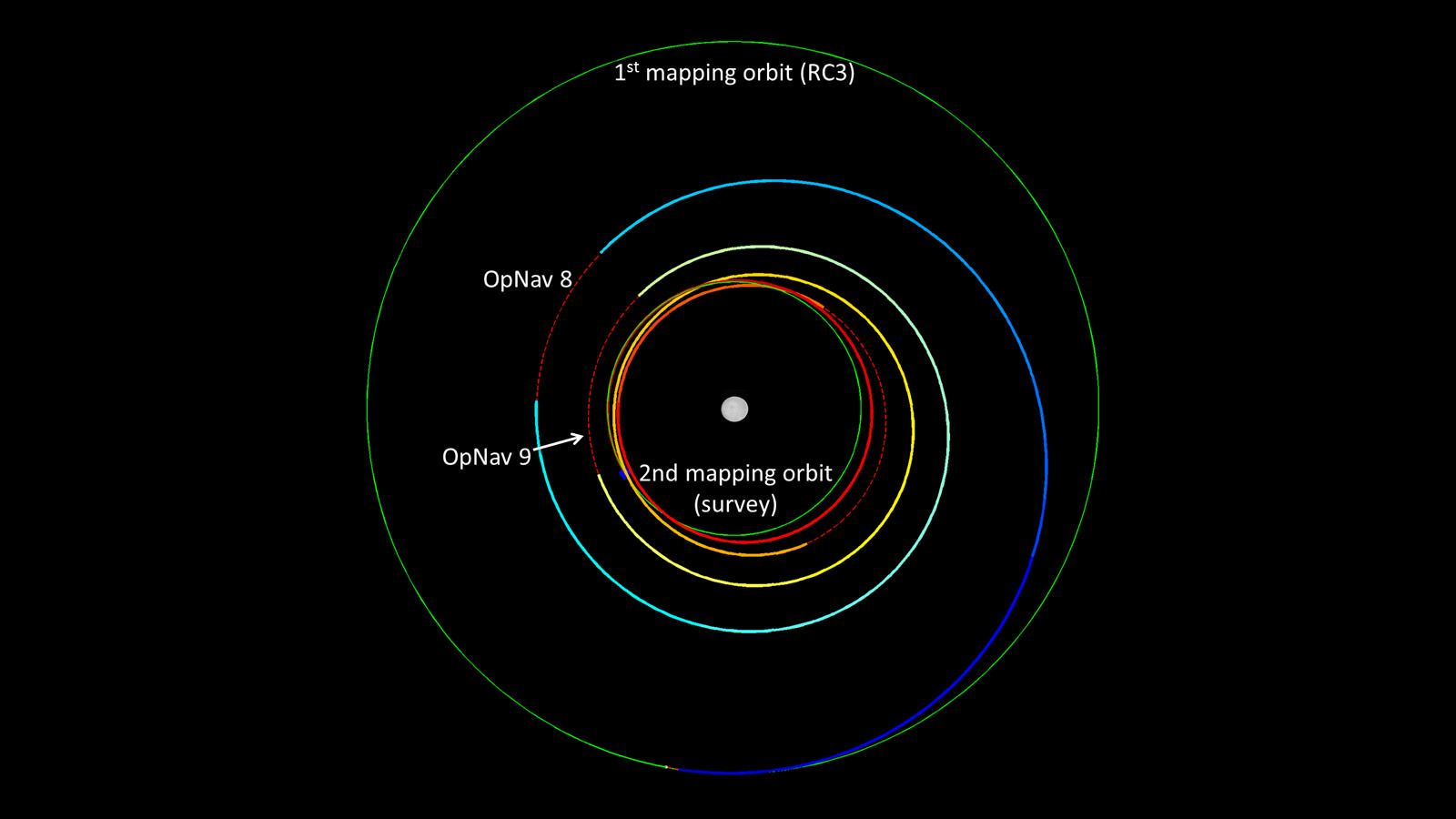
Dawn’s spiral descent from its first mapping orbit (RC3) to its second (survey). The two mapping orbits are shown in green. The color of Dawn’s trajectory progresses through the spectrum from blue, when it began ion-thrusting on May 9, to red, when ion-thrusting concludes on June 3. The red dashed sections show where Dawn is coasting, mostly for telecommunications. The first two coast periods include OpNav 8 and 9. Image credit: NASA/JPL-Caltech
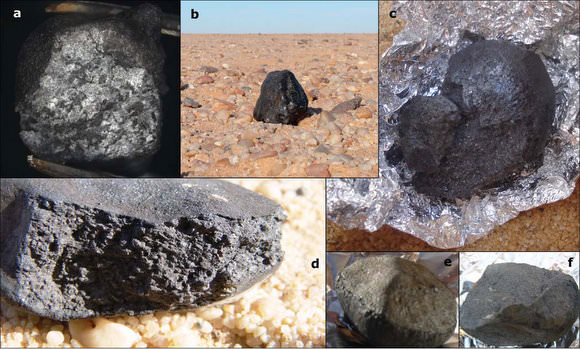
Various meteorites from 2008 TC3.
Credit: P. Jenniskens, et. al. Click image for full description
Asteroids, meteors, and meteorites … It might be fair to say these rocks from space inspire both wonder and fear among us Earthlings. But knowing a bit more about each of them and how they differ may eliminate some potential misgivings. While all these rocks originate from space, they have different names depending their location — i.e. whether they are hurtling through space or hurtling through the atmosphere and impacting Earth’s surface.
In simplest terms here are the definitions:
Asteroid: a large rocky body in space, in orbit around the Sun.
Meteoroid: much smaller rocks or particles in orbit around the Sun.
Meteor: If a meteoroid enters the Earth’s atmosphere and vaporizes, it becomes a meteor, which is often called a shooting star.
Meteorite: If a small asteroid or large meteoroid survives its fiery passage through the Earth’s atmosphere and lands on Earth’s surface, it is then called a meteorite.
Another related term is bolide, which is a very bright meteor that often explodes in the atmosphere. This can also be called a fireball.
Let’s look at each in more detail:
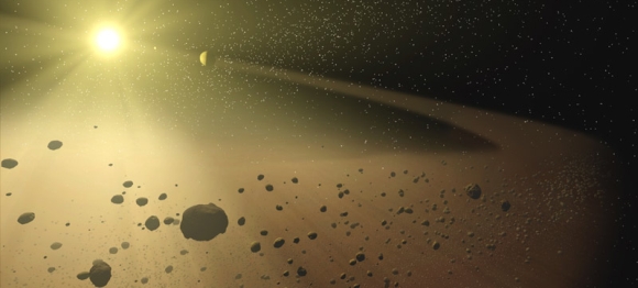
Asteroids An artists impression of an asteroid belt. Credit: NASA
Asteroids are found mainly in the asteroid belt, between Mars and Jupiter. Sometimes their orbits get perturbed or altered and some asteroids end up coming closer to the Sun, and therefore closer to Earth. In addition to the asteroid belt, however, there have been recent discussions among astronomers about the potential existence of large number asteroids in the Kuiper Belt and Oort Cloud. You can read a paper about this concept here, and a good article discussing the topic here.
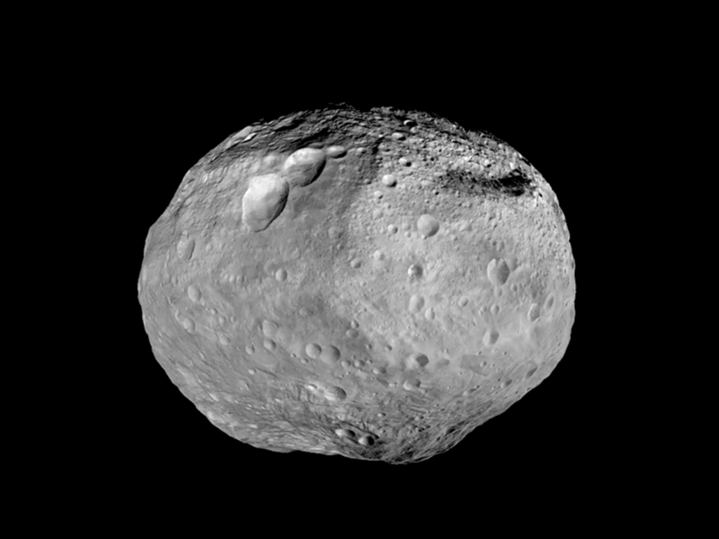
The asteroid Vesta as seen by the Dawn spacecraft. Credit: NASA/JPL-Caltech/UCAL/MPS/DLR/IDA
Asteroids are sometimes referred to as minor planets or planetoids, but in general, they are rocky bodies that do not have an atmosphere. However, a few have their own moons. Our Solar System contains millions of asteroids, many of which are thought to be the shattered remnants of planetesimals – bodies within the young Sun’s solar nebula that never grew large enough to become planets.
The size of what classifies as an asteroid is not extremely well defined, as an asteroid can range from a few meters wide – like a boulder — to objects that are hundreds of kilometers in diameter. The largest asteroid is asteroid Ceres at about 952 km (592 miles) in diameter, and Ceres is so large that it is also categorized as a dwarf planet.
Most asteroids are made of rock, but as we explore and learn more about them we know that some are composed of metal, mostly nickel and iron. According to NASA, a small portion of the asteroid population may be burned-out comets whose ices have evaporated away and been blown off into space. Recently, astronomers have discovered some asteroids that mimic comets in that gas and dust are emanating from them, and as we mentioned earlier, there appears to be a large number of bodies with asteroid-like compositions but comet-like orbits.
How Often Do Asteroids Hit Earth?
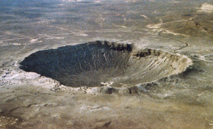
Meteor Crater near Winslow, Arizona. Image credit: NASA.
While we know that some asteroids pass very close to Earth’s orbit around the Sun, we’ve been lucky in the history of humanity that we haven’t had a large asteroid hit Earth in the past several thousand years. It wasn’t until satellite imagery of Earth became widely available that scientists were able to see evidence of past asteroid impacts.
One of the more famous impact craters on Earth is Meteor Crater in Arizona in the US, which was made by an impact about 50,000 years ago. But there are about 175 known impact around the world – a few are quite large, like Vredefort Crater in South Africa which has an estimated radius of 190 kilometers (118 miles), making it the world’s largest known impact structure on Earth. Another notable impact site is off the coast of the Yucatan Peninsula in Mexico, and is believed to be a record of the event that led to the extinction of the dinosaurs 65 million years ago. You can see images of some of the most impressive Earth impact craters here.
These days, asteroid impacts are less of a threat. NASA estimates that about once a year an automobile-sized asteroid enters Earth’s atmosphere, creates an impressive fireball and disintegrates before ever reaching the surface. Studies of Earth’s history indicate that about once every 5,000 years or so on average an object the size of a football field hits Earth and causes significant damage. Once every few million years on average an object large enough to cause regional or global disaster impacts Earth. You can find more information about the frequency of impacts in this article from NASA.
Meteors, Meteoroids and Bolides
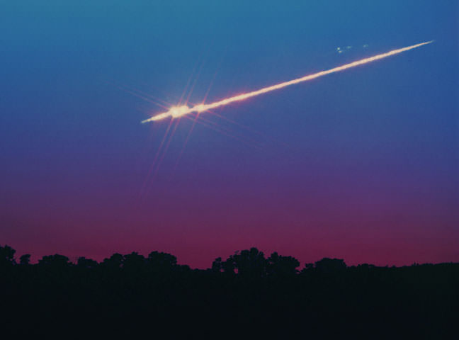
A bright meteor from September 21, 1994. Credit: John Chumack.
Space debris smaller than an asteroid are called meteoroids. A meteoroid is a piece of interplanetary matter that is smaller than an asteroid and frequently are only millimeters in size. Most meteoroids that enter the Earth’s atmosphere are so small that they vaporize completely and never reach the planet’s surface. When they burn up during their descent, they create a beautiful trail of light known as a meteor, sometimes called a shooting star.
Mostly these are harmless, but larger meteors that explode in the atmosphere – sometimes called bolides — can create shockwaves, which can cause problems. In February 2013 a meteor that exploded over Chelyabinsk, Russia shattered windows with its air blast. This meteoroid or bolide was estimated to be 18 meters (59 feet) in diameter. In 1908, a rocky meteoroid less than 100 meters in diameter is believed to have entered the atmosphere over the Tunguska region of Siberia in 1908 and the resulting shockwave knocked down trees for hundreds of square kilometers
How often is Earth hit by meteroids?
Chelyabinsk fireball recorded by a dashcam from Kamensk-Uralsky north of Chelyabinsk where it was still dawn.
Because of the Chelyabinsk meteor in 2013, astronomers have acquired more information about the frequency of larger meteors that hit Earth, and there is now a growing consensus that the Earth gets hit by bigger space rocks more often than we previously thought. You can read more about that concept here.
This video from the B612 Foundation shows a visualization of the location of 26 space rocks that hit Earth between 2000 and 2013, each releasing energy equivalent to some of our most powerful nuclear weapons. The B612 foundation says that a Hiroshima-scale asteroid explosion happens in our atmosphere on average once a year, but many are not detected because they explode high in the atmosphere, or because most of the Earth’s surface is water and even a large percentage of land is fairly uninhabited by humans.
Estimates vary of how much cosmic dust and meteors enter Earth’s atmosphere each day, but range anywhere from 5 to 300 metric tons. Satellite observations suggest that 100-300 metric tons of cosmic dust enter the atmosphere each day. This figure comes from the rate of accumulation in polar ice cores and deep-sea sediments of rare elements linked to cosmic dust, such as iridium and osmium.
But other measurements – which includes meteor radar observations, laser observations and measurements by high altitude aircraft — indicate that the input could be as low as 5 metric ton per day. Read more about this here.
For a documented list of bolide events, you can check out this page from JPL.
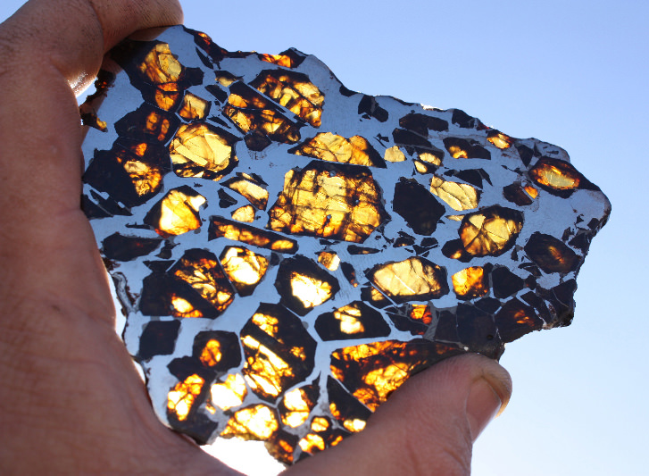
Meteorite A stunning slice of the Glorieta pallasite meteorite cut thin enough to allow light to shine through its many olivine crystals. Credit: Mike Miller
If any part of a meteoroid survives the fall through the atmosphere and lands on Earth, it is called a meteorite. Although the vast majority of meteorites are very small, their size can range from about a fraction of a gram (the size of a pebble) to 100 kilograms (220 lbs) or more (the size of a huge, life-destroying boulder). Meteorites smaller than 2mm are classified as micrometeorites.
Meteorites have traditionally been divided into three broad categories, depending on their structure, chemical and isotopic composition and mineralogy. Stony meteorites are rocks, mainly composed of silicate minerals; iron meteorites that are largely composed of metallic iron-nickel; and, stony-iron meteorites that contain large amounts of both metallic and rocky material.
Meteorites have also been found on the Moon and Mars and conversely, scientists have traced the origination of the meteorites found here on Earth to four other bodies: the Moon, Mars, the asteroid 4 Vesta, and the comet Wild 2. Meteorites are the source of a great deal of the knowledge that we have have about the composition of other celestial bodies.
How Often Do Meteorites Hit Earth?
On Feb. 28, 2009, Peter Jenniskens (SETI/NASA), finds his first 2008TC3 meteorite after an 18-mile long journey. “It was an incredible feeling,” Jenniskens said. The African Nubian Desert meteorite of Oct 7, 2008 was the first asteroid whose impact with Earth was predicted while still in space approaching Earth. 2008TC3 and Chelyabinsk are part of the released data set. (Credit: NASA/SETI/P.Jenniskens)
According to the Planetary Science Institute, it is estimated that probably 500 meteorites reach the surface of the Earth each year, but less than 10 are recovered. This is because most fall into water (oceans, seas or lakes) or land in remote areas of the Earth that are not accessible, or are just not seen to fall.
In short, the difference between asteroids and meteors all comes down to a question of location. Asteroids are always found in space. Once it enters an atmosphere, it becomes a meteor, and then a meteorite after it hits the ground. Each are made of the same basic materials – minerals and rock – and each originated in space. The main difference is where they are when they are being observed.