NASA Robot arrives at ‘New’ Landing Site holding Clues to Ancient Water Flow on Mars

Opportunity investigates Tisdale 2 rock showing indications of ancient Martian water flow. NASA's Mars Exploration Rover Opportunity used its front hazard-avoidance camera to take this picture showing the rover's arm extended toward a light-toned rock, "Tisdale 2," during Sol 2695 of the rover's work on Mars (Aug. 23, 2011). The composition of Tisdale 2 is unlike any rock studied by Opportunity since landing 7.5 years ago. It is about 12 inches (30 centimeters) tall. Credit: NASA/JPL-Caltech

[/caption]

Opportunity has begun a whole new mission at the vast expanse of Endeavour Crater promising a boatload of new science discoveries.

Scientists directing NASA’s Mars Opportunity rover gushed with excitement as they announced that the aging robot has discovered a rock with a composition unlike anything previously explored on the Red Planet’s surface – since she landed on the exotic Martian plains 7.5 years ago – and which offers indications that liquid water might have percolated or flowed at this spot billions of years ago.

Barely three weeks ago Opportunity arrived at the rim of the gigantic 14 mile ( 22 km) wide crater named Endeavour after an epic multi-year trek, and for the team it’s literally been like a 2nd landing on Mars – and the equivalent of the birth of a whole new mission of exploration at an entirely ‘new’ landing site.

“This is like having a brand new landing site for our veteran rover,” said Dave Lavery, program executive for NASA’s Mars Exploration Rovers at NASA Headquarters in Washington. “It is a remarkable bonus that comes from being able to rove on Mars with well-built hardware that lasts.”

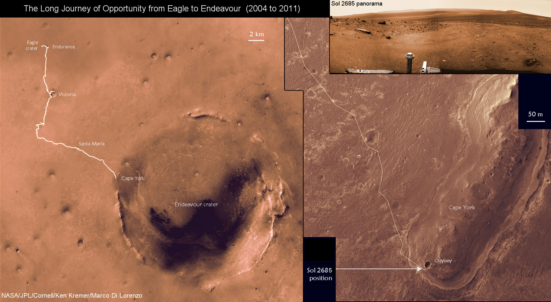
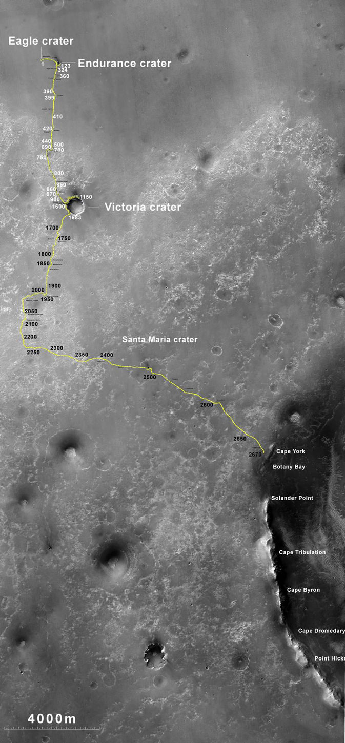
Opportunity has traversed an incredible distance of 20.8 miles (33.5 km) across the Meridiani Planum region of Mars since landing on January 24, 2004 for a 3 month mission – now 30 times longer than the original warranty.

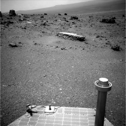
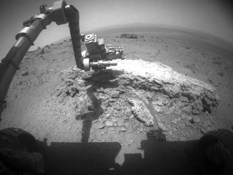
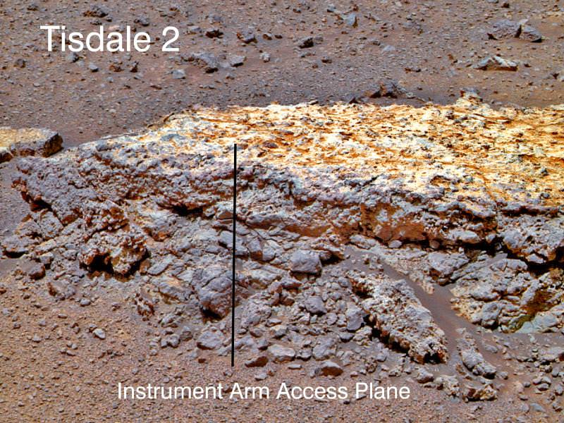
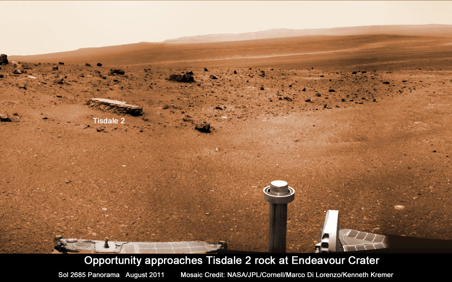
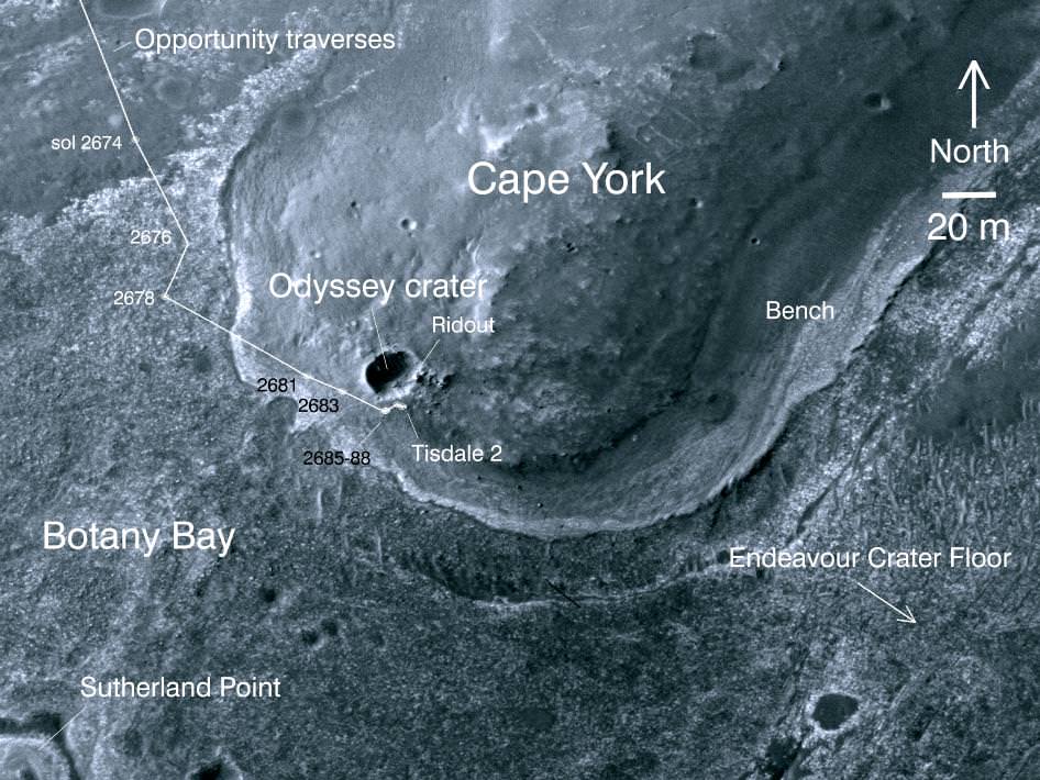
“Tisdale 2” is the name of the first rock that Opportunity drove to and investigated after reaching Endeavour crater and climbing up the rim at a low ridge dubbed ‘Cape York’.

This rock, informally named "Tisdale 2," was the first rock the NASA's Mars Rover Opportunity examined in detail on the rim of Endeavour crater. It has textures and composition unlike any rock the rover examined during its first 90 months on Mars. Its characteristics are consistent with the rock being a breccia -- a type of rock fusing together broken fragments of older rocks. Image credit: NASA/JPL-Caltech/Cornell/ASU

Endeavour’s rim is heavily eroded and discontinuous and divided into a series of segmented and beautiful mountainous ridges that offer a bonanza for science.

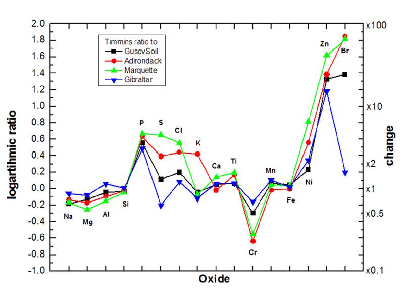
“This is not like anything we’ve ever seen before. So this is a new kind of rock.” said Steve Squyres, principal investigator for Opportunity at Cornell University in Ithaca, N.Y at a briefing for reporters on Sept. 1.

“It has a composition similar to some volcanic rocks, but there’s much more zinc and bromine than we’ve typically seen. We are getting confirmation that reaching Endeavour really has given us the equivalent of a second landing site for Opportunity.”

Tisdale 2 is a flat-topped rock about the size of a footstool that was blasted free by the impact that formed the tennis court sized “Odyssey” crater from which it was ejected.

“The other big take-away message, and this is to me the most interesting thing about Tisdale, is that this rock has a huge amount of zinc in it, way more zinc than we have ever seen in any Martian rock. And we are puzzling, we are thinking very hard over what that means,” Squyres speculated.

Bright veins cutting across outcrop in a section of Endeavour crater's rim called "Botany Bay" are visible in the foreground and middle distance of this view assembled from images taken by the navigation camera on Opportunity during Sol 2,681on Mars (Aug. 9, 2011). Credit: NASA/JPL-Caltech

Squyres said that high levels of zinc and bromine on Earth are often associated with rocks in contact with flowing water and thus experiencing hydrothermal activity and that the impact is the source of the water.

“When you find rocks on Earth that are rich in zinc, they typically form in a place where you had some kind of hydrothermal activity going on, in other words, you have water that gets heated up and it flows through the rocks and it can dissolve out and it can get redeposited in various places,” Squyres explained.

“So this is a clue, not definitive proof yet, but this is a clue that we may be dealing with a hydrothermal system here, we may be dealing with a situation where water has percolated or flowed or somehow moved through these rocks, maybe as vapor, maybe as liquid, don’t know yet.”

“But it has enhanced the zinc concentration in this rock to levels far in excess of anything we’ve ever seen on Mars before. So that’s the beginning of what we expect is going to be a long and very interesting story about these rocks.”

Endeavour crater was chosen three years ago as the long term destination for Opportunity because it may hold clues to a time billions and billions of years ago when Mars was warmer and wetter and harbored an environment that was far more conducive to the formation of life beyond Earth.

Endeavour Crater Panorama from Opportunity, Sol 2681, August 2011
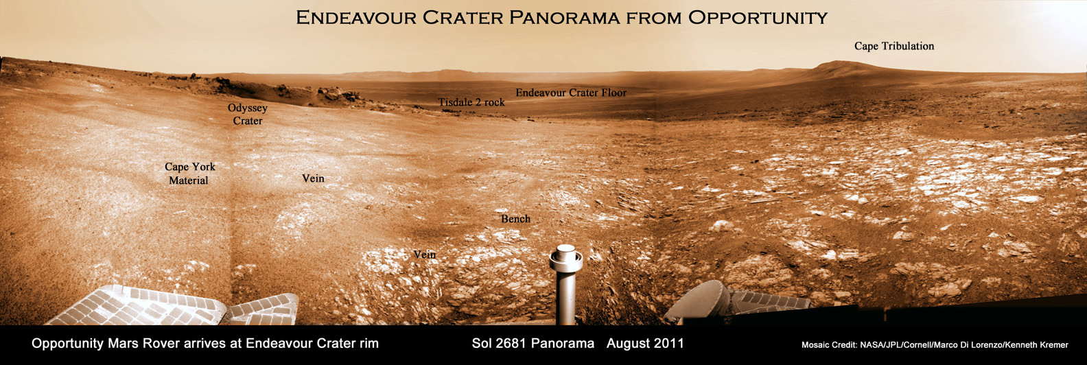
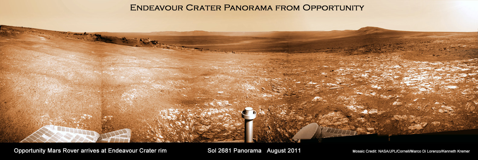
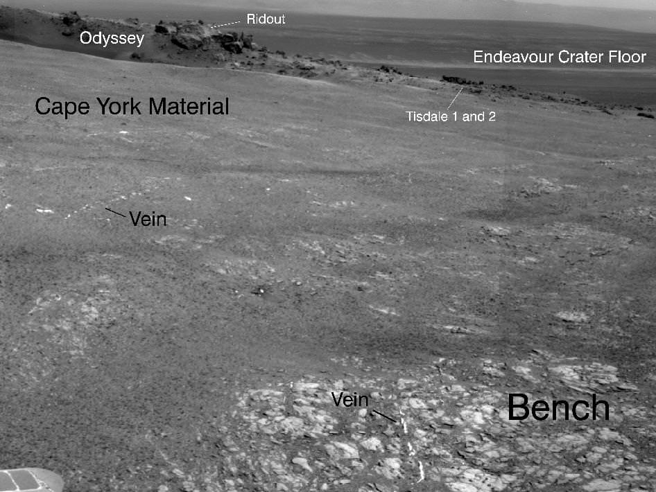
Opportunity arrived at the rim of Endeavour on Sol 2681, August 9, 2011 and climbed up the ridge known as Cape York. Odyssey crater is visible at left. The rover has driven to Tisdale 2 rock at the outskirts of Odyssey to investigate the ejecta blocks which may hold clues to ancient water flow on Mars. Distant portions of Endeavour’s rim - as far as 13 miles away – visible in the background. The rover will likely drive eventually to the Cape Tribulation rim segment at right which holds a mother lode of clay minerals. This photo mosaic was stitched together from raw images taken by Opportunity on Sol 2681.
Mosaic Credit: NASA/JPL/Cornell/Marco Di Lorenzo/Kenneth Kremer

Signatures of clay minerals, or phyllosilicates, were detected at several spots at Endeavour’s western rim by observations from the Compact Reconnaissance Imaging Spectrometer for Mars (CRISM) aboard NASA’s Mars Reconnaissance Orbiter (MRO).

“The motherlode of clay minerals is on Cape Tribulation. The exposure extends all the way to the top, mainly on the inboard side,” said Ray Arvidson, the rover’s deputy principal investigator at Washington University in St. Louis.

Opportunity Traverse Map: 2004 to 2011. The yellow line on this map shows where NASA's Mars Rover Opportunity has driven from the place where it landed in January 2004 -- inside Eagle crater, at the upper left end of the track -- to a point approaching the rim of Endeavour crater. The map traces the route through the 2,670th Martian day, or sol, of Opportunity's work on Mars (July 29, 2011). Image credit: NASA/JPL-Caltech/MSSS/NMMNHS.

Phyllosilicates are clay minerals that form in the presence of pH neutral water and which are far more hospitable to the possible genesis of life compared to the sulfate rich rocks studied in the more highly acidic aqueous environments examined by both the Opportunity and Spirit rovers thus far.

“We can get up the side of Cape Tribulation,” said Arvidson. It’s not unlike Husband Hill for Spirit. We need to finish up first at Cape York, get through the martian winter and then start working our way south along Solander Point.

The general plan is that Opportunity will probably spend the next several months exploring the Cape York region for before going elsewhere. “Just from Tisdale 2 we know that we have something really new and different here,” said Squyres.

“On the final traverses to Cape York, we saw ragged outcrops at Botany Bay unlike anything Opportunity has seen so far, and a bench around the edge of Cape York looks like sedimentary rock that’s been cut and filled with veins of material possibly delivered by water,” said Arvidson. “We made an explicit decision to examine ancient rocks of Cape York first.”

So far at least the terrain at Cape York looks safe for driving with good prospects for mobility.

Opportunity approaches Tisdale 2 rock at Endeavour Crater rim
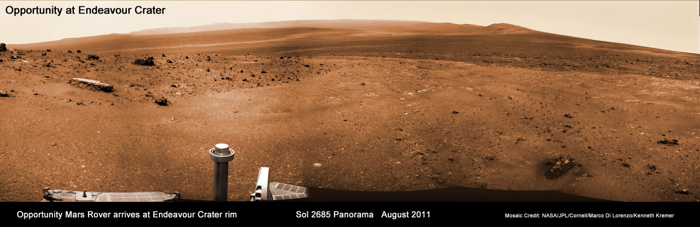
Opportunity Mars rover climbed up the ridge known as Cape York and drove to the flat topped Tisdale 2 rock at upper left to analyze it with the science instruments on the robotic arm. This photo mosaic was stitched together from raw images taken by Opportunity on Sol 2685, August 2011.
Mosaic Credit: NASA/JPL/Cornell/Marco Di Lorenzo/Kenneth Kremer

“The good news is that, as predicted, we have hard packed soils like the plains at Gusev that Spirit saw before getting to the Columbia Hills,” said Arvidson. “The wheel tracks at Cape York are very, very shallow. So if anything we will have some skid going downhill the slopes of 5 to 10 degrees on the inboard side which we can correct for.”

“We are always on the lookout for sand traps. We are particularly sensitized to that after the Spirit situation. So far it’s clear sailing ahead.”

Opportunity will then likely head southwards towards an area dubbed “Botany Bay” and eventually drive some 1.5 km further to the next ridge named Cape Tribulation and hopefully scale the slopes in an uphill search for that mother lode of phyllosilicates.

“My strong hope – if the rover lasts that long – is that we will have a vehicle that is capable of climbing Cape Tribulation just as we climbed Husband Hill with Spirit. So it’s obvious to try if the rover is capable, otherwise we would try something simpler. But even if we lose a wheel we still have a vehicle capable of a lot of science,” Squyres emphasized. “Then we would stick to lower ground and more gently sloping stuff.”

“The clear intention as we finish up at Cape York, and look at what to do next, is that we are going to work our way south. We will focus along the crater’s rim. We will work south along the rim of Endeavour unless some discovery unexpectedly causes us to do something else.”

“We will go where the science takes us !” Squyres stated.

Opportunity is in generally good health but the rover is showing signs of aging.

“All in all, we have a very senior rover that’s showing her age, she has some arthritis and some other issues but generally, she’s in good health, she’s sleeping well at night, her cholesterol levels are excellent and so we look forward to productive scientific exploration for the period ahead,” said John Callas, project manager for Opportunity at NASA’s Jet Propulsion Laboratory in Pasadena, Calif.

“This has the potential to be the most revealing destination ever explored by Opportunity,” said Lavery. “This region is substantially different than anything we’ve seen before. We’re looking at this next phase of Opportunity’s exploration as a whole new mission, entering an area that is significantly different in the geologic context than anything we’ve seen with the rovers.”

This image taken from orbit shows the path of the path driven by NASA's Mars Exploration Rover Opportunity in the weeks around the rover's arrival at the rim of Endeavour crater. The sol number (number of Martian days since the rover landed on Mars) are indicated along the route. Sol 2674 corresponds to Aug. 2, 2011; Sol 2688 corresponds to Aug. 16, 2011. Image credit: NASA/JPL-Caltech/University of Arizona
Elevated Zinc and Bromine in Tisdale 2 Rock on Endeavour Rim. This graphic presents information gained by examining part of the Martian rock called "Tisdale 2" with the alpha particle X-ray spectrometer on Mars rover Opportunity and comparing the composition measured there with compositions of other targets examined by Opportunity and its rover twin, Spirit. The comparison targets are soil in Gusev crater, examined by Spirit; the relatively fresh basaltic rock Adirondack, examined by Spirit; the stony meteorite Marquette examined by Opportunity; and Gibraltar, an example of sulfate-rich bedrock examined by Opportunity. The target area on Tisdale 2, called "Timmins 1," contains elevated levels of bromine (Br), zinc (Zn), phosphorus (P), sulfur (S) and chlorine (Cl) relative to the non-sulfate-rich comparison rocks, and high levels of zinc and phosphorus relative to Gibraltar. Credit: NASA/JPL-Caltech/Cornell/Max Planck Institute/University of Guelph

Read Ken’s continuing features about Mars starting here
Opportunity Arrives at Huge Martian Crater with Superb Science and Scenic Outlook
Opportunity Snaps Gorgeous Vistas nearing the Foothills of Giant Endeavour Crater
Dramatic New NASA Animation Depicts Next Mars Rover in Action
Opportunity Rover Heads for Spirit Point to Honor Dead Martian Sister; Science Team Tributes
Opportunity Rover Completes Exploration of fascinating Santa Maria Crater
Opportunity Surpasses 30 KM Driving and Snaps Skylab Crater in 3 D

Book Review: Lunar and Planetary Rovers

The book Lunar and Planetary Rovers offers a bit of a primer before NASA's Mars Science Laboratory launches to Mars this November. Image Credit: NASA/Spinger/Praxis

[/caption]
Ordinarily if a book attempts to cover crewed and unmanned missions – the book is a compilation of space flight history in general. This is not the case when it comes to Springer/Praxis’ offering Lunar and Planetary Rovers. Written by Anthony Young, the book details both crewed (the Apollo “J” missions) and unmanned rovers (Pathfinder, Mars Exploration Rovers and Curiosity). The book is not a perfect blending of the two interconnected, yet separate programs – but it does have much to offer.

First published in 2010, the book is a well-researched, detailed account of the lunar rovers that flew on Apollos 15, 16 and 17 and the robotic explorers that have scoured the face of the red planet – Mars.

Lunar and Planetary Rovers covers both the manned rovers used on the final three Apollo lunar missions and the unmanned rovers used to explore the surface of Mars - under one book. Photo Credit: NASA/Jack Schmitt

Lunar and Planetary Rovers fills a need for an account of efforts to get wheels on other worlds. The book is filled with numerous photographs (both color and black and white) that have never been published before. In terms of the Apollo Program, Lunar and Planetary Rovers is replete with quotes from the astronauts that drove the lunar rovers on the Moon. In terms of the unmanned planetary rovers, the book pulls from the engineers and scientists that made (and make) these machines work.

The book is 305 pages long. It could have stood to be a few pages longer. One glaring omission in the general body of the book is that of the Lunokhods (these amazing machines are mentioned in the appendix of the book). Given that the Lunokhods bridge the gap between the Apollo Program’s manned lunar rovers (in that they both rolled across the lunar regolith) and the robotic planetary rovers – this is a fairly significant gap in coverage of the topic. The book also does not tie these two, separate, programs together very well (the jump from one topic to the other is jarring and not done consistently).

For some reason, Russia's Lunokhod Rover, the first unmanned rover to explore another world, is only mentioned in passing - at the very end of the book. Photo Credit: NASA

Even when one considers this slight flaw – the book still provides an accurate and useful history of rovers. Lunar and Planetary Rovers can be purchased on the secondary market (Amazon) for approximately $5 (that is including shipping and handling) the book is a good buy for those wanting information concerning the topic. For those that are not interested in the traditional, paper, format a Kindle edition is available for around $25.

With the launch of the Mars Science Laboratory (MSL) or Curiosity as it is more commonly known currently scheduled to take place this November – this book serves as a historical reminder as to how the technology employed by Curiosity was both developed and refined.

Lunar and Planetary Rovers details all of the rovers to traverse the surface of the red planet, from the Mars Pathfinder; seen here, to Curiosity - currently set to launch on Nov. 25, 2011. Photo Credit: NASA.gov

NASAs Lunar Mapping Duo Encapsulated and Ready for Sept. 8 Liftoff

Twin GRAIL Lunar Mappers being enclosed with payload fairing atop Delta II rocket. Spacecraft technicians monitor the movement of a section of the clamshell-shaped Delta payload fairing as it encloses NASA's twin Gravity Recovery and Interior Laboratory spacecraft at Space Launch Complex 17B on Cape Canaveral Air Force Station in Florida. Liftoff is slated for Sept. 8 at 8:37 a.m. EDT. Credit: NASA/Jim Grossmann

[/caption]

NASA’s powerful lunar mapping duo of GRAIL spacecraft are now poised for liftoff in just one weeks time on Thursday, Sept. 8.

Mission managers held a Flight Readiness Review on Wednesday (Aug.31) and gave a tentative approval to begin fueling the Delta II rockets second stage on Sept. 2 and 3 after evaluating all issues related to the rocket, launch pad and payloads.

Launch preparations are proceeding on schedule towards an early morning lift off from the seaside Space Launch Complex 17B (SLC-17B) at Cape Canaveral Air Force Station, Florida. There are two instantaneous launch windows at 8:37:06 a.m. and 9:16:12 a.m. EDT lasting one second each.

“Launch vehicle and spacecraft closeouts will begin on Tuesday, and the Launch Readiness Review is also scheduled for Tuesday morning,” NASA KSC spokesman George Diller told Universe Today.

“This morning’s launch countdown dress rehearsal went fine.”

“Delta II 2nd stage fueling has been rescheduled for Friday and Saturday [Sept. 2 and 3]. Last evening a software error was found in the launch processing system data base. ULA (United Launch Alliance) decided they would like to look for any additional errors before the fueling begins. There is no impact to the launch date and currently no work is scheduled on Sunday or on Labor Day,” said Diller.

The launch period extends through Oct. 19, with liftoff occurring approximately four minutes earlier each day in case of a delay. The flight plan was designed to avoid a pair of lunar eclipses occurring on December 10th, 2011 and June 4th 2012 which would interfere with the missions operations and science.

The team is keeping a close watch on the weather as the season’s next Atlantic Ocean storm heads westwards. Katia has just been upgraded to Hurricane status and follows closely on the heels of the continuing vast destruction, misery and deaths caused by Hurricane Irene earlier this week.

“The preliminary weather forecast is favorable for launch day as long as the wind remains out of the west as is currently forecast for that time of the morning,” Diller told me.

Twin GRAIL Lunar Mappers are secured atop Delta II rocket and await enclose in the Delta payload fairing. The fairing will protect the spacecraft from the impact of aerodynamic pressure and heating during ascent and will be jettisoned once the spacecraft is outside the Earth's atmosphere. Credit: NASA/Jim Grossmann

The twin probes known as GRAIL-A and GRAIL-B (Gravity Recovery and Interior Laboratory) were encapsulated inside the clamshell like payload fairing on Aug. 23 The nearly identical spacecraft are mounted side by side and sit atop the Centaur upper stage.

The fairing shields the spacecraft from aerodynamic pressures, friction and extreme heating for the first few minutes of flight during ascent through the Earth atmosphere.

This Delta II Heavy booster rocket is the most powerful version of the Delta II family built by ULA. The booster’s first stage is augmented with larger diameter solid rocket motors.

GRAIL was processed for launch inside at the Astrotech payload processing facility in Titusville, Fla. See my GRAIL spacecraft photos from inside the Astrotech clean room facilities here.

“The GRAIL spacecraft inside the handling can departed Astrotech and arrived at the launch pad, SLC-17B on Aug. 18” said Tim Dunn, NASA’s Delta II Launch Director in an interview with Universe Today. “The spacecraft was then hoisted by crane onto the Delta II launch vehicle and the spacecraft mate operation was flawlessly executed by the combined ULA and NASA Delta II Team.”

An Integrated Systems Test (IST) of the mated booster and payload was completed on Aug. 22

Technicians prepare twin GRAIL spacecraft for enclosure in the Delta payload fairing. Credit: NASA/Jim Grossmann

The dynamic duo will orbit the moon in a tandam formation just 50 kilometers above the lunar surface with an average separation of 200 km. During the 90 day science phase the goal is to determine the structure of the lunar interior from crust to core and to advance understanding of the thermal evolution of the moon.

GRAIL-A & GRAIL-B will measure the lunar gravity field with unprecedented resolution up to 100 times improvement on the near side and 1000 times improvement for the far side.

NASA’s twin GRAIL Science Probes ready for Lunar Expedition
GRAIL B (left) and GRAIL A (right) spacecraft are mounted side by side on top of a payload adapter inside the clean room at Astrotech Space Operations facility. The spacecraft await lunar launch on Sept. 8, 2011. Credit: Ken Kremer

Read Ken’s continuing features about GRAIL

GRAIL Lunar Twins Mated to Delta Rocket at Launch Pad
GRAIL Twins ready for NASA Science Expedition to the Moon: Photo Gallery

First Image Captured by NASAs Jupiter bound Juno; Earth – Moon Portrait

Earth & Moon Portrait - First Photo transmitted from Jupiter Bound Juno. This image of Earth (on the left) and the moon (on the right) was taken by NASA's Juno spacecraft on Aug. 26, 2011, when the spacecraft was about 6 million miles (9.66 million kilometers) away. It was taken by the spacecraft's onboard camera, JunoCam. Credit: NASA/JPL-Caltech

[/caption]

NASA’s solar powered Jupiter bound Juno orbiter has captured her first image – a beautiful portrait of the Earth & Moon – since the probe blasted off from the home planet.

Juno lifted off 25 days ago at 12: 25 p.m. on August 5 from Space Launch Complex 41 at Cape Canaveral Air Force Station in Florida. The spacecraft snapped the portrait with the onboard JunoCam camera on August 26 after journeying some 6 million miles (9.66 million km) from Earth and while traveling at a velocity of 77,600 miles per hour (124,900 kilometers per hour) relative to the sun.

“The image of the Earth Moon system is a rather unique perspective that we can get only by stepping outside of our home planet,” said Scott Bolton, Juno principal investigator, in an exclusive interview with Universe Today. Bolton is from the Southwest Research Institute in San Antonio.

“On our way to Jupiter, we’ve looked back at home and managed to take this amazing image.”

“Earth looking much like any other planet or star from a distance is glorious as this somewhat average looking “star” is home to all of humanity. Our companion, the moon, so beautiful and important to us, stands out even less.”

“We appear almost average and inconspicuous, yet all of our history originates here. It makes one wonder just how many other planets or solar systems might contain life like ours,” Bolton told me.

Juno casts a shadow back toward Earth and Space Shuttle Launch Pad 39A and the shuttle crawler way (at left) seconds after liftoff from adjacent Launch Pad 41 at Cape Canaveral, Florida. View from the VAB Roof. Credit: Ken Kremer

The Juno team commanded the probe to take the image as part of the checkout phase of the vehicles instruments and subsystems.

“The JunoCam instrument turn on and check out were planned activities. The instrument is working great and in fact, all the instruments that we’ve turned on thus far have been working great,” Bolton added.

So far the spacecraft is in excellent health and the team has completed the checkout of the Waves instrument and its two Flux Gate Magnetometer sensors and deployment of its V-shaped electric dipole antenna.

“We have a couple more instruments still to do,” Bolton noted.

The team reports that Juno also performed its first precession, or reorientation maneuver, using its thrusters and that the first trajectory control maneuver (TCM-1) was cancelled as unnecessary because of the extremely accurate targeting provided by the Atlas V rocket.

The portrait shot is actually not Juno’s last photo of her home.

The 8000 pound (3,600 kilogram) probe will fly by Earth once more on October 9, 2013 for a gravity assisted speed boost of 16,330 MPH (7.3 km/sec) to accelerate Juno past the asteroid belt on its long journey to the Jovian system.

Juno soars skyward to Jupiter on Aug. 5 from launch pad 41 at Cape Canaveral Air Force Station at 12:25 p.m. EDT. View from the VAB roof. Credit: Ken Kremer

JunoCam will collect new photos and the other science instruments will make measurements as Juno cartwheels past Earth during the slingshot to Jupiter.

Juno is on a 5 year and 1.7 Billion mile (2.8 Billion km) trek to the largest planet in our solar system. When she arrives at Jupiter on July 4, 2016, Juno will become the first polar orbiting spacecraft at the gas giant.

During a one year science mission – entailing 33 orbits lasting 11 days each – the probe will plunge to within about 3000 miles (5000 km) of the turbulent cloud tops and collect unprecedented new data that will unveil the hidden inner secrets of Jupiter’s genesis and evolution.

The goal is to find out more about the planets origins, interior structure and atmosphere, observe the aurora, map the intense magnetic field and investigate the existence of a solid planetary core.

“This is a remarkable sight people get to see all too rarely,” said Bolton in a NASA statement about the Earth-Moon photo. “This view of our planet shows how Earth looks from the outside, illustrating a special perspective of our role and place in the universe. We see a humbling yet beautiful view of ourselves.”

NASA’s Jet Propulsion Laboratory manages the Juno mission. The spacecraft was designed and built by Lockheed Martin Space Systems, Denver.

Juno and Booster Streak Across the Stars
NASA's Juno spacecraft and its spent Centaur upper rocket stage are captured in this telescope view as they move across the field of stars. The five-minute, timed exposure was acquired on Aug. 5 11:18pm Eastern time (Aug. 6 at 3:18 UTC) when Juno was at a distance of about 195,000 miles (314,000 kilometers) from Earth. The images were taken remotely by amateur astronomer Scott Ferguson using Global Rent-a-Scope's GRAS-016 Takahashi Widefield Refractor, which is located in Nerpio, Spain. Credit: Scott Ferguson
Juno Spacecraft Cruise Trajectory to Jupiter
This graphic shows Juno's trajectory, or flight path, from Earth to Jupiter. The spacecraft travels around the Sun, to a point beyond the orbit of Mars where it fires its main engine a couple of times. These deep space maneuvers set up the Earth flyby maneuver that occurs approximately two years after launch. The Earth flyby gives Juno the boost in velocity it needs to coast all the way to Jupiter. Juno arrives at Jupiter in July 2016. Credit: NASA/JPL-Caltech
View of Juno’s position on Aug. 24, 2011 nearly 6 million miles distant from Earth visualized by NASA’s Eyes on the Solar System website.

Read my continuing features about Juno
Juno Blasts off on Science Trek to Discover Jupiter’s Genesis
Juno Jupiter Orbiter poised at Launch Pad for Aug. 5 Blastoff
JUNO Orbiter Mated to Mightiest Atlas rocket for Aug. 5 Blastoff to Jupiter
Solar Powered Jupiter bound JUNO lands at Kennedy Space Center

Opportunity Arrives at Huge Martian Crater with Superb Science and Scenic Outlook

Endeavour Crater Panorama from Opportunity, Sol 2681, August 2011. NASA’s Opportunity Mars rover arrived at the rim of huge Endeavour crater on Sol 2681, August 9, 2011 and climbed up the ridge known as Cape York. A small crater dubbed ‘Odyssey’ is visible in the foreground at left. The rover has now driven to the outskirts of Odyssey to investigate the ejecta blocks which may stem from an ancient and wetter Martian Epoch. Opportunity snapped this soaring panorama showing distant portions of Endeavour’s rim - as far as 13 miles away - in the background. This photo mosaic was stitched together from raw images taken by Opportunity on Sol 2681. Mosaic Credit: NASA/JPL/Cornell/Marco Di Lorenzo/Kenneth Kremer

[/caption]NASA’s Mars Opportunity rover has finally arrived at the huge Martian crater named Endeavour that simultaneously offers a mother lode of superb scenery and potentially the “Mother of all Martian Science”. The epic journey took nearly three years.

The intrepid robogirl is now climbing uphill on a Scientific quest that may well produce bountiful results towards the most important findings ever related to the search for life on Mars. Opportunity arrived at the western rim of the 13 mile (21 km) wide Endeavour crater on the 2681st Sol , or Martian day, of a mission only warrantied to last 90 Sols.

See our new Opportunity panoramic mosaics (Marco Di Lorenzo & Ken Kremer) illustrating the magnificent scenery and science targets now at hand on the surface of the Red Planet, thanks to the diligent work of the science and engineering teams who created the twin Mars Exploration Rover (MER) vehicles – Spirit & Opportunity.

Opportunity made landfall at Endeavour at a ridge of the discontinuous crater rim named Cape York and at a spot dubbed “Spirit Point” – in honor or her twin sister Spirit which stopped communicating with Earth about a year ago following more than six years of active science duty. See traverse map mosaic.

The martian robot quickly started driving northwards up the gnetle slopes of Cape York and has reached a small crater named “Odyssey” – the first science target, Dr. Matt Golembek told Universe Today. Golembek is a Senior Research Scientist with the Mars Exploration Program at the Jet Propulsion Laboratory (JPL) in Pasadena, Calif.

“Large ejecta blocks are clearly visible on the rim of Odyssey crater,” said Golembek. The crater is about 66 feet (20 m) in diameter.

Odyssey is a small impact crater of interest to the team because it features exposed material from Mars ancient Noachian era that was ejected when the crater was excavated long ago. Opportunity carefully drove over several days to one of those ejecta blocks – a flat topped rock nicknamed Tisdale 2.

Endeavour Crater Panorama from Opportunity, Sol 2685, August 2011
NASA’s Opportunity Mars rover arrived at the rim of huge Endeavour crater on Sol 2681, August 9, 2011 and is climbed up the ridge known as Cape York. She drove to the flat topped Tisdale 2 rock at upper left to analyze it with the science instruments on the robotic arm. Opportunity snapped this soaring panorama showing distant portions of Endeavour’s rim - as far as 13 miles away - in the background. This photo mosaic was stitched together from raw images taken by Opportunity on Sol 2685.
Mosaic Credit: NASA/JPL/Cornell/Marco Di Lorenzo/Kenneth Kremer

“Opportunity is at a block of Odyssey crater ejecta called Tisdale 2 and the rock appears different from anything else we have seen,” Golembek explained.

Starting on Sol 2688 (Aug. 16) the rover began a science campaign time to investigate the rock with the instruments at the terminus of its robotic arm or IDD (Instrument Deployment Device) that will continue for some period of time.

“We are about to start an IDD campaign,” Golembek stated.

The Long Journey of Opportunity form Eagle to Endeavour Crater (2004 to 2011).
This map mosaic shows Opportunity’s epic trek of nearly eight years from landing at Eagle crater on January 24, 2004 to arrival at the giant 13 mile (21 km) diameter Endeavour crater in August 2011. Opportunity arrived the Endeavour’s rim and then drove up a ridge named Cape York. The photomosaic at top right show the outlook from Cape York on Sol 2685 (August 2011).
Mosaic Credit: NASA/JPL/Cornell/Kenneth Kremer/Marco Di Lorenzo

The team reports that the soil at Cape York is also of a different texture than any that Opportunity has seen so far on her incredible 20 mile (33 km) trek across the Meridiani Planum region of Mars. So far they haven’t seen of the iron-rich concretions, nicknamed “blueberries,” which have been plentiful on the surface along the way at numerous locations Opportunity has stopped at and investigated over the past 90 months. Initially the prime mission was projected to last 3 months – the remainder has been a huge bonus.

The science team is directing Opportunity to hunt for clay minerals, also known as phyllosilicates, that could unlock the secrets of an ancient Epoch on Mars stretching back billions and billions of years ago that was far wetter and very likely more habitable and welcoming to life’s genesis.

Phyllosilicate minerals form in neutral water that would be vastly more friendly to any potential Martian life forms – if they ever existed in the past or present. Signatures for phyllosilicates were detected by the CRISM instrument aboard NASA’s powerful Mars Reconnaissance Orbiter (MRO) spacecraft circling Mars

Flat-topped Tisdale 2 rock. Credit: NASA/JPL-Caltech
'Ridout' Rock on Rim of Odyssey Crater. Opportunity looked across small Odyssey crater on the rim of much larger Endeavour crater to capture this raw image from its panoramic camera during the rover's 2,685th Martian day, or sol, of work on Mars (Aug. 13, 2011). From a position south of Odyssey, this view is dominated by a rock informally named "Ridout" on the northeastern rim of Odyssey. The rock is roughly the same size as the rover, which is 4.9 feet (1.5 meters) long. Credit: NASA/JPL-Caltech/Cornell/ASU

Read my continuing features about Mars starting here
Opportunity Snaps Gorgeous Vistas nearing the Foothills of Giant Endeavour Crater
Dramatic New NASA Animation Depicts Next Mars Rover in Action
Opportunity Rover Heads for Spirit Point to Honor Dead Martian Sister; Science Team Tributes
Opportunity Rover Completes Exploration of fascinating Santa Maria Crater
Opportunity Surpasses 30 KM Driving and Snaps Skylab Crater in 3 D

How Did Jupiter Shape Our Solar System?

Shortly after forming, Jupiter was slowly pulled toward the sun. Saturn was also pulled in and eventually, their fates became linked. When Jupiter was about where Mars is now, the pair turned and moved away from the sun. Scientists have referred to this as the "Grand Tack," a reference to the sailing maneuver. Credit: NASA/GSFC

[/caption]

Jupiter hasn’t always been in the same place in our solar system. Early in the history of our solar system, Jupiter moved inward towards the sun, almost to where Mars currently orbits now, and then back out to its current position.

The migration through our solar system of Jupiter had some major effects on our solar system. Some of the effects of Jupiter’s wanderings include effects on the asteroid belt and the stunted growth of Mars.

What other effects did Jupiter’s migration have on the early solar system and how did scientists make this discovery?

In a research paper published in the July 14th issue of Nature, First author Kevin Walsh and his team created a model of the early solar system which helps explain Jupiter’s migration. The team’s model shows that Jupiter formed at a distance of around 3.5 A.U (Jupiter is currently just over 5 A.U from the sun) and was pulled inward by currents in the gas clouds that still surrounded the sun at the time. Over time, Jupiter moved inward slowly, nearly reaching the same distance from the sun as the current orbit of Mars, which hadn’t formed yet.

“We theorize that Jupiter stopped migrating toward the sun because of Saturn,” said Avi Mandell, one of the paper’s co-authors. The team’s data showed that Jupiter and Saturn both migrated inward and then outward. In the case of Jupiter, the gas giant settled into its current orbit at just over 5 a.u. Saturn ended its initial outward movement at around 7 A.U, but later moved even further to its current position around 9.5 A.U.

Astronomers have had long-standing questions regarding the mixed composition of the asteroid belt, which includes rocky and icy bodies. One other puzzle of our solar system’s evolution is what caused Mars to not develop to a size comparable to Earth or Venus.

Artist's conception of early planetary formation from gas and dust around a young star. Image Credit: NASA/JPL-Caltech

Regarding the asteroid belt, Mandell explained, “Jupiter’s migration process was slow, so when it neared the asteroid belt, it was not a violent collision but more of a do-si-do, with Jupiter deflecting the objects and essentially switching places with the asteroid belt.”

Jupiter’s slow movement caused more of a gentle “nudging” of the asteroid belt when it passed through on its inward movement. When Jupiter moved back outward, the planet moved past the location it originally formed. One side-effect of caused by Jupiter moving further out from its original formation area is that it entered the region of our early solar system where icy objects were. Jupiter pushed many of the icy objects inward towards the sun, causing them to end up in the asteroid belt.

“With the Grand Tack model, we actually set out to explain the formation of a small Mars, and in doing so, we had to account for the asteroid belt,” said Walsh. “To our surprise, the model’s explanation of the asteroid belt became one of the nicest results and helps us understand that region better than we did before.”

With regards to Mars, in theory Mars should have had a larger supply gas and dust, having formed further from the sun than Earth. If the model Walsh and his team developed is correct, Jupiter foray into the inner solar system would have scattered the material around 1.5 A.U.

Mandell added, “Why Mars is so small has been the unsolvable problem in the formation of our solar system. It was the team’s initial motivation for developing a new model of the formation of the solar system.”

An interesting scenario unfolds with Jupiter scattering material between 1 and 1.5 AU. Instead of the higher concentration of planet-building materials being further out, the high concentration led to Earth and Venus forming in a material-rich region.

The model Walsh and his team developed brings new insight into the relationship between the inner planets, our asteroid belt and Jupiter. The knowledge learned not only will allow scientists to better understand our solar system, but helps explain the formation of planets in other star systems. Walsh also mentioned, “Knowing that our own planets moved around a lot in the past makes our solar system much more like our neighbors than we previously thought. We’re not an outlier anymore.”

If you’d like to access the paper (subscription or paid/university access required), you can do so at: http://www.nature.com/nature/journal/v475/n7355/full/nature10201.html

Source: NASA Solar System News, Nature

GRAIL Lunar Twins Mated to Delta Rocket at Launch Pad

GRAIL Lunar Twins hoisted to top of Launch Pad 17B at Cape Canaveral. NASA's twin Gravity Recovery and Interior Laboratory (GRAIL) spacecraft are lifted to the top of their launch pad at Space Launch Complex 17B at Cape Canaveral Air Force Station in Florida and were mated to their Delta II Heavy Booster Rocket. They are wrapped in plastic to prevent contamination outside the clean room. Launch is scheduled for Sept. 8. Credit: NASA/Kim Shiflett

[/caption]

With blastoff just 2 ½ weeks away, NASA’s GRAIL lunar twins completed a major milestone towards launch today (Aug. 18) when they were mated to the top of the Delta II Heavy rocket that will boost them to the moon. Launch is slated for Sept. 8 at 8:37 a.m. EDT.

This morning the tightly wrapped $496 Million duo took their last trip on Earth before beginning their nearly four month journey to the Moon. GRAIL A & GRAIL B were carefully transported 15 miles (25 km) from the clean room processing facility at the Astrotech Space Operation’s payload processing facility in Titusville, Fla to Space Launch Complex 17B (SLC-17B) at Cape Canaveral Air Force Station in Florida.

“The GRAIL spacecraft transportation convoy to SLC-17B departed Astrotech at 11:55 p.m. EDT on Wednesday, Aug. 17, “ said Tim Dunn, NASA’s Delta II Launch Director in an interview with Universe Today. “The spacecraft, inside the handling can, arrived at the launch pad, SLC-17B, at 4:00 a.m. this morning.”

“The spacecraft was then hoisted by the Mobile Service Tower crane onto the Delta II launch vehicle and the spacecraft mate was complete at 9:30 a.m.”

Crane lifts GRAIL A & B to the top of the Mobile Service Tower on Aug. 18. The probes are wrapped in protective plastic sheeting inside the handling can. Credit: NASA/Kim Shiflett

Technicians joined the nearly identical and side by side mounted spacecraft onto the top of the guidance section adapter of the Delta’s second stage. The Delta II was built by United Launch Alliance (ULA).

“Tomorrow, the GRAIL spacecraft team will perform functional testing on both the GRAIL A and GRAIL B spacecraft,” Dunn told me.

“The next major milestone will be performance of the Integrated Systems Test (IST) on Monday, (8/22/11).

“Today’s spacecraft mate operation was flawlessly executed by the combined ULA and NASA Delta II Team,” said Dunn.

These tests will confirm that the spacecraft is healthy after the fueling and transport operations. After further reviews of the rocket and spacecraft systems the GRAIL team will install the payload fairing around the lunar probes.

NASA’s twin GRAIL Science Probes ready for Lunar Expedition
GRAIL B (left) and GRAIL A (right) spacecraft are mounted side by side on top of a payload adapter inside the clean room at Astrotech Space Operations facility. The spacecraft await lunar launch on Sept. 8, 2011. Credit: Ken Kremer

NASA’s dynamic duo will orbit the moon to determine the structure of the lunar interior from crust to core and to advance understanding of the thermal evolution of the moon.

“We are about to finish one chapter in the GRAIL story and open another,” said Maria Zuber, GRAIL’s principal investigator, based at the Massachusetts Institute of Technology in Cambridge in a statement. “Let me assure you this one is a real page-turner. GRAIL will rewrite the book on the formation of the moon and the beginning of us.”

The GRAIL launch will be the last for a Delta II in Florida.

GRAIL A & B lunar twins arrive at Pad 17B. Credit: NASA/Kim Shiflett

Technicians hoist GRAIL A & B lunar twins inside the handling can at Pad 17B. Credit: NASA/Kim Shiflett

Read my prior features about GRAIL
GRAIL Twins ready for NASA Science Expedition to the Moon: Photo Gallery

3 D Alien Snowman Graces Vesta

3D Snowman craters and Vesta’s Equatorial Region from Dawn. This anaglyph image of Vesta's equator with the crater feature named “snowman” (center, right) was put together from two clear filter images, taken on July 24, 2011 by the framing camera instrument aboard NASA's Dawn spacecraft. The anaglyph image shows hills, troughs, ridges and steep craters. The framing camera has a resolution of about 524 yards (480 meters) per pixel. Use red-green (or red-blue) glasses to view in 3-D (left eye: red; right eye: green [or blue]). Credit: NASA/JPL-Caltech/UCLA/MPS/DLR/IDA

[/caption]

An alien ‘Snowman’ on an alien World.

The ‘Snowman’ is a string of three craters and is among the most strange and prominent features discovered on a newly unveiled world in our solar system – the giant asteroid Vesta. It reminded team members of the jolly wintertime figure – hence its name – and is a major stand out in the 3 D image above and more snapshots below.

Until a few weeks ago, we had no idea the ‘Snowman’ even existed or what the rest of Vesta’s surface actually looked like. That is until NASA’s Dawn spacecraft approached close enough and entered orbit around Vesta on July 16 and photographed the Snowman – and other fascinating Vestan landforms.

“Each observation of Vesta is producing incredible views more exciting than the last”, says Dawn’s Chief Engineer, Dr. Marc Rayman of the Jet Propulsion Laboratory. “Every image revealed new and exotic landscapes. Vesta is unlike any other place humankind’s robotic ambassadors have visited.”

‘Snowman’ craters on Vesta. What is the origin of the ‘Snowman’?
The science team is working to determine how the ‘Snowman’ formed. This set of three craters is nicknamed ‘Snowman” and is located in the northern hemisphere of Vesta. NASA’s Dawn spacecraft obtained this image with its framing camera on August 6, 2011. This image was taken through the framing camera’s clear filter aboard the spacecraft. The framing camera has a resolution of about 280 yards (260 meters). Credit: NASA/JPL-Caltech/UCLA/MPS/DLR/IDA

The Snowman is located in the pockmarked northern hemisphere of Vesta – see the full frame image below. The largest of the three craters is some 70 km in diameter. Altogether the trio spans roughly 120 km in length. See Image at Left

“Craters, Craters, Craters Everywhere” – that’s one thing we can now say for sure about Vesta.

And soon we’ll known a lot more about the mineralogical composition of the craters and Vesta because spectral data is now pouring in from Dawn’s spectrometers.

After being captured by Vesta, the probe “used its ion propulsion system to spiral around Vesta, gradually descending to its present altitude of 2700 kilometers (1700 miles),” says Chief Engineer Rayman. “As of Aug.11, Dawn is in its survey orbit around Vesta.”

Dawn has now begun its official science campaign. Each orbit currently last 3 days.

Dawn’s scientific Principal Investigator, Prof. Chris Russell of UCLA, fondly calls Vesta the smallest terrestrial Planet !

I asked Russell for some insight into the Snowman and how it might have formed. He outlined a few possibilities in an exclusive interview with Universe Today.

“Since there are craters, craters, craters everywhere on Vesta it is always possible that these craters struck Vesta in a nearly straight line but many years apart,” Russell replied.

“On the other hand when we see ‘coincidences’ like this, we are suspicious that it is really not a coincidence at all but that an asteroid that was a gravitational agglomerate [sometimes called a rubble pile] struck Vesta.”

“As the loosely glued together material entered Vesta’s gravity field it broke apart with the parts moving on slightly different paths. Three big pieces landed close together and made adjacent craters.”

So, which scenario is it ?

“Our science team is trying to figure this out,” Russell told me.

“They are examining the rims of the three craters to see if the rims are equally degraded, suggesting they are of similar age. They will try to see if the ejecta blankets interacted or fell separately”

“The survey data are great but maybe we will have to wait until the high altitude mapping orbit [HAMO] to get higher resolution data on the rim degradation.”

Dawn will descend to the HAMO mapping orbit in September.

Close-up View of 'Snowman' craters.
This image of the set of three craters informally nicknamed ‘Snowman’ was taken by Dawn’s framing camera on July 24, 2011 after the probe entered Vesta’s orbit. Snowman is located in the northern hemisphere of Vesta. The image was taken from a distance of about of about 3,200 miles (5,200 kilometers). The framing camera was provided by Germany. Credit: NASA/JPL-Caltech/UCLA/MPS/DLR/IDA

Russell and the Dawn team are elated with the fabulous results so far, some of which have been a total surprise.

How old is the Snowman ?

“We date the age of the surface by counting the number of craters on it as a function of size and compare with a model that predicts the number of craters as a function of size and as a function of time from the present,” Russell responded.

“However this does not tell us the age of a crater. If the crater destroyed all small craters in its bowland and left a smooth layer [melt] then the small crater counts would be reset at the impact.”

“Then you could deduce the age from the crater counts. You can also check the degradation of the rim but that is not as quantitative as the small crater counts in the larger crater. The team is doing these checks but they may have to defer the final answer until they obtain the much higher resolution HAMO data,” said Russell.

Besides images, the Dawn team is also collecting spectral data as Dawn flies overhead.

“The team is mapping the surface with VIR- the Visible and Infrared Mapping Spectrometer – and will have mineral data shortly !”, Russell told me.

At the moment there is a wealth of new science data arriving from space and new missions from NASA’s Planetary Science Division are liftoff soon. Juno just launched to Jupiter, GRAIL is heading to the launch pad and lunar orbit and the Curiosity Mars Science Laboratory (MSL) is undergoing final preflight testing for blastoff to the Red Planet.

Russell had these words of encouragement to say to his fellow space explorers;

“Dawn wishes GRAIL and MSL successful launches and hopes its sister missions join her in the exploration of our solar system very shortly.”

“This year has been and continues to be a great one for Planetary Science,” Russell concluded.

Detailed 'Snowman' Crater
Dawn obtained this image with its framing camera on August 6, 2011. This image was taken through the camera’s clear filter. The camera has a resolution of about 260 meters per pixel. This image shows a detailed view of three craters, informally nicknamed 'Snowman' by the camera’s team members. Credit: NASA/JPL-Caltech/UCLA/MPS/DLR/IDA
Dawn snaps First Full-Frame Image of Asteroid Vesta – Snowman at Left
NASA's Dawn spacecraft obtained this image of the giant asteroid Vesta with its framing camera on July 24, 2011. It was taken from a distance of about 3,200 miles (5,200 kilometers). Dawn entered orbit around Vesta on July 15, and will spend a year orbiting the body. The Dawn mission to Vesta and Ceres is managed by NASA's Jet Propulsion Laboratory, Pasadena, Calif. The framing cameras were built by the Max Planck Institute for Solar System Research, Katlenburg-Lindau, Germany, and the German Aerospace Center (DLR) Institute of Planetary Research, Berlin. Credit: NASA/JPL-Caltech/UCLA/MPS/DLR/IDA

Read my prior features about Dawn
NASA Unveils Thrilling First Full Frame Images of Vesta from Dawn
Dawn Spirals Down Closer to Vesta’s South Pole Impact Basin
First Ever Vesta Vistas from Orbit – in 2D and 3D
Dawn Exceeds Wildest Expectations as First Ever Spacecraft to Orbit a Protoplanet – Vesta
Dawn Closing in on Asteroid Vesta as Views Exceed Hubble
Dawn Begins Approach to Asteroid Vesta and Snaps First Images
Revolutionary Dawn Closing in on Asteroid Vesta with Opened Eyes

Titan’s Giant Cloud Explained

This image from the Cassini spacecraft, shows a huge arrow-shaped storm measuring 1,500km in length. Image Credit: NASA/JPL/SSI

[/caption]

Titan is making news again, this time with Cassini images from 2010 showing a storm nearly as big as Texas.  Jonathan Mitchell from UCLA and his research team have published their findings which help answer the question:

What could cause such large storms to develop on a freezing cold world?

For starters, the huge arrow isn’t a cosmic detour sign reminding us to “Attempt No Landings” on Jupiter’s moon Europa.

In the study by Mitchell and his team,  a model of Titan’s global weather was created to understand how atmospheric waves affect weather patterns on Titan.  During their research, the team discovered a “stenciling” effect that creates distinct cloud shapes, such as the arrow-shaped cloud shown in the Cassini image above.

“These atmospheric waves are somewhat like the natural, resonant vibration of a wine glass,” Mitchell said. “Individual clouds might ‘ring the bell,’ so to speak, and once the ringing starts, the clouds have to respond to that vibration.”

Titan is the only other body in the solar system (aside from Earth) known to have an active “liquid cycle”.  Much like Titan’s warmer cousin Earth, the small moon has an atmosphere primarily composed of Nitrogen.  Interestingly enough Titan’s atmosphere is roughly the same mass as Earth’s and has about 1.5 times the surface pressure.  At the extremely low temperatures on Titan, hydrocarbons such as methane appear in liquid form, rather than the gaseous form found on Earth.

With an active liquid both on the surface and in the atmosphere of Titan, clouds form and create rain. In the case of Titan, the rain on the plain is mainly methane.  Water on Titan is rock-hard, due to temperatures hovering around -200 c.

Studies of Titan show evidence of liquid runoff, rivers and lakes, further emphasizing Titan’s parallels to Earth. Researchers believe better understanding of Titan may offer clues to understanding Earth’s early atmosphere.  In another parallel to earth, the weather patterns on Titan created by the atmospheric waves can create intense rainstorms, sometimes with more than 20 times Titan’s average seasonal rainfall. These intense storms may cause erosion patterns that help form the rivers seen on Titan’s surface.  Mitchell described Titan’s climate as “all-tropics”,  basically comparing the weather to what is usually found near Earth’s equator.  Could these storms be Titan’s equivalent of  monsoon season?

Mitchell stated “Titan is like Earth’s strange sibling — the only other rocky body in the solar system that currently experiences rain”.  Mitchell also added, “In future work, we plan to extend our analysis to other Titan observations and make predictions of what clouds might be observed during the upcoming season”.

The research was published Aug. 14 in the online edition of the journal Nature Geoscience .

If you’d like to learn more about the Cassini mission, visit: http://saturn.jpl.nasa.gov/index.cfm

JPL’s ‘Muscle Car’ – MSL – Takes Center Stage

JPL's 'Hot Wheels' - The Mars Science Laboratory or 'Curiosity' is being prepared to launch to mars this November. Photo Credit: Alan Walters/awaltersphoto.com

[/caption]
CAPE CANAVERAL, Fla. – NASA is experiencing what could be dubbed a “summer of planetary exploration.” With the Juno mission to Jupiter on its way as of Aug. 5, NASA is prepping not one but two more missions – this time to terrestrial bodies – specifically the Moon and Mars.

On Sept. 8 NASA is planning to launch GRAIL (Gravity Recovery And Interior Laboratory). This mirror image spacecraft consists of two elements that will fly in tandem with one another and scan the Moon from its core to its crust. This mission will serve to expand our understanding of the mechanics of how terrestrial bodies are formed. GRAIL will provide the most accurate gravitational map of the Moon to date.

The aeroshell that will cover both the MSL rover and its jetpack landing system. Photo Credit: Alan Walters/awaltersphoto.com

When it comes to upcoming projects that have “celebrity” status – few can compete with the Mars Science Laboratory (MSL) or Curiosity. The six-wheeled rover was part of a media event Friday Aug. 12 that included the “Sky-Crane” jetpack that is hoped will safely deliver the car-sized rover the Martian surface. Also on display was the back half of the rover’s aeroshell which will keep the robot safe as in enters the red planet’s atmosphere.

Numerous engineers were available for interview, one expert on hand to explain the intricacies of how Curiosity works was the Rover Integration Lead on the project, Peter Illsley.

One fascinating aspect of MSL is how the rover will land. As it pops free of the aeroshell, a jet pack will conduct a powered descent to Mars’ surface. From there the rover will be lowered to the ground via wires, making Curiosity look like an alien spider descending from its web. Once the rover makes contact with the ground, the wires will be severed and the “Sky-Crane” will fly off to conduct a controlled crash. Ben Thoma, the mechanical lead on this aspect of the project, described how he felt about what it is like to work on MSL.

MSL is slated to launch this November atop a United Launch Alliance (ULA) Atlas V 541 rocket. If everything goes according to plan the rover will begin exploring Mars’ Gale Crater for a period of approximately two years. In every way Curiosity is an upgraded, super-charged version of the rovers that have preceded her. The Pathfinder rover tested out many of the concepts that led to the Mars Exploration Rovers Spirit and Opportunity and now MSL has incorporated lessons learned to take more robust scientific explorations of the Martian surface.

The "Sky-Crane" jetpack that will be used to slowly lower the MSL rover to the Martian surface. Photo Credit: Alan Walters/awaltersphoto.com