Latest Images from Chandrayaan-1

Chandrayaan-1 captured this view of a nearly full Earth on March 25, 2009 at 07:03:03 UTC. India is at the center of the image. Credit: ISRO. Click for larger version

[/caption]
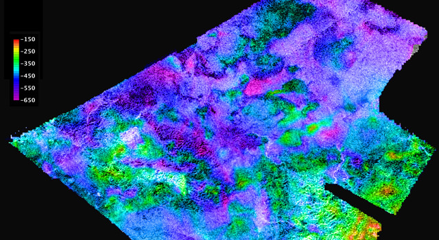
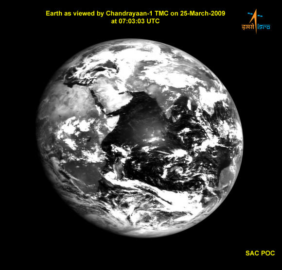
ISRO and NASA have recently released some of the latest images taken by the Chandrayaan-1 spacecraft orbiting the Moon. Above, Chandrayaan 1 looks back at Earth, and fittingly, India is at the center of the image. And here’s a link to another similar image, taken about an hour earlier. Below, are images taken by the Mini-SAR, the imaging radar instrument that NASA has tagging along on the Chandrayaan-1 orbiter. “The new radar images are not only visually arresting, but they will be extremely useful in unraveling the complex geological history of the Moon as a whole,” said Dr. Paul Spudis, principal investigator for Mini-SAR. “We are hard at work finishing the calibration of our instrument, which is required in order to make definite statements about the nature of the radar backscatter signature, the tell-tale sign of the presence or absence of water ice.”


Rozhdestvensky crater on the Moon. Credit: ISRO/NASA/JHUAPL/LPI

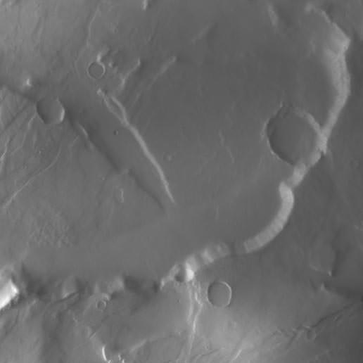
As you can see, the Mini-SAR gathers data in strips as it orbits the Moon, which are later assembled to create larger images. This composite shows Rozhdestvensky K, a moderately sized (42-kilometer [26-mile] diameter) impact crater on the southern rim of the larger crater Rozhdestvensky, near the moon’s north pole. These Mini-SAR images show massive slumping, as result of wall collapse caused by gravity. NASA says these images demonstrate that Mini-SAR images will be of great value in deciphering the geological evolution of the moon.
A new crater on the Moon. Credit: ISRO/NASA/JHUAPL/LPI


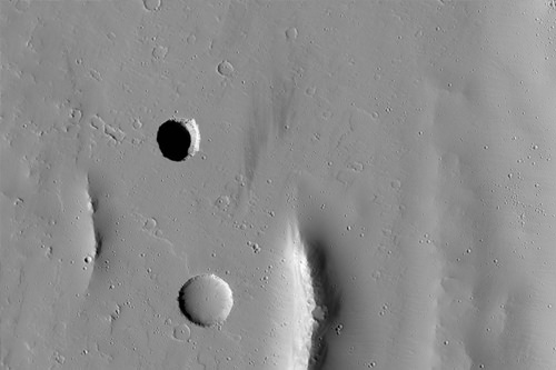
Here’s a very young, fresh impact crater (3 kilometers [nearly 2 miles] in diameter) on the western limb of the moon near the crater Sylvester, taken by the Mini-SAR instrument aboard India’s Chandrayaan-1 lunar orbiter. Fresh features on the moon display “radar bright” (i.e., high backscatter) material around them. This is caused by the presence of very fresh ejecta, which includes many angular blocks and rough material. These deposits are the cause of high radar backscatter.
Mini-SAR's coverage of the Moon so far. Credit: ISRO/NASA/JHUAPL/LPI

Coverage maps of the Mini-SAR experiment aboard India’s Chandrayaan-1 lunar orbiter as of mid-March 2009. Mini-SAR has mapped about 80% of both of the moon’s poles. The polar excluded zone is a consequence of the side-looking nature of the instrument; these zones will be filled by both scatterometry (in which the instrument views the moon straight downward at low resolution) and high-angle SAR, in which operators roll the spacecraft 9 to 12 degrees to look at areas closer to the ground track.

For more images check out ISRO’s Chandrayaan-1 webpages, and NASA’s Mini-SAR site, and for more detail about the Mini-SAR images, check out Dr. Spudis’ blog.

Spirit’s Serendipitous Science

A bright patch of soil churned up by Spirit on March 28, 2009. Credit: NASA/JPL

[/caption]

The scientists and engineers working with the Spirit rover on Mars were hoping the aging rover could take the short route over the top of a small plateau called “Home Plate;” she could get to her next destination quicker and easier. But with the rover’s right front wheel not working, the rover was unable to make the climb from the side of the plateau where Spirit spent the majority of the Martian winter (with her solar panels tilted towards the sun) up to the top. So, Spirit is now making her way around Home Plate, where the less desirable path may have led to a serendipitous discovery. The rover’s immobile right-front wheel has churned up a long stripe of bright soil. Could this bright soil be sulfur or silica, providing evidence of past action of water at this site? The rover will test the soil today with it’s alpha particle X-ray spectrometer. And this isn’t the first time Spirit’s bum wheel has churned up something interesting.

In 2006, Spirit uncovered another patch of bright soil. The material was found to be sulfur-rich and consisted of sulfate salts associated with iron, and likely calcium. “This material could have been left behind by water that dissolved these minerals underground, then came to the surface and evaporated, or it could be a volcanic deposit formed around ancient gas vents,” said Dr. Ray Arvidson back in 2006. He is the deputy principal investigator for NASA’s twin Mars rovers, Spirit and Opportunity.

View of Home Plate from Orbit (HiRISE) Credit: NASA, JPL, U of AZ

“These salts could have been concentrated by hydrothermal liquid or vapor moving through the local rocks,” said rover science team member Dr. Albert Yen, a geochemist at JPL. Two other patches of bright soil uncovered by Spirit before were also sulfur-rich, but each had similarities to local rock compositions that were different at the three sites, suggesting localized origins.

This most recent discovery was made on the 1,861st Martian day, or sol, of Spirit’s mission on Mars (March 28, 2009). After the drive, the rover took the image above with its front hazard-avoidance camera, looking back at the tracks from the drive.

As usual since losing the use of its right-front wheel in 2006, Spirit drove backwards, and the immobile right-front wheel turned up the soil.

The Sol 1861 drive took the rover past the northwest corner of the low plateau called “Home Plate,” making progress on a route around the western side of Home Plate. The edge of Home Plate forms the horizon on the right side of this image. Husband Hill is on the horizon on the left side. For scale, the parallel rover wheel tracks are about 1 meter (40 inches) apart. The rover’s hazard-avoidance cameras take “fisheye” wide-angle images.

Source: JPL’s Photojournal

Virtual Fly-Over of Titan

Cassini's radar mapper has obtained stereo views of close to 2 percent of Titan's surface during 19 flybys over the last five years. Image credit: NASA/JPL/USGS

[/caption]
Hang on, and enjoy a virtual flyover of Saturn’s moon Titan! Data from Cassini’s radar instrument have been used to create new flyover maps of Saturn’s largest moon. The maps show the topography of Titan in 3-D, and illustrating the height of the 1,200-meter (4,000-foot) mountain tops, the north polar lake country, the vast dunes more than 100 meters (300 feet) high that crisscross the moon, and the thick flows that may have oozed from possible ice volcanoes. “These flyovers let you take in the bird’s-eye sweeping views of Titan, the next best thing to being there,” said Randy Kirk, from the Science Center at the U.S. Geological Survey, who created the maps.. “We’ve mapped many kinds of features, and some of them remind me of Earth. Big seas, small lakes, rivers, dry river channels, mountains and sand dunes with hills poking out of them, lava flows.” Click the image above to see one of the movies.

During its mission, Cassini plans to map more than three percent of Titan’s surface in 3-D. About 38 percent of Titan’s surface has been mapped with radar so far. On March 27, Cassini will complete its 52nd targeted flyby of Titan.

Kirk used some of the 20 or so areas where two or more overlapping radar measurements were obtained during 19 Titan flybys to create the 3. These stereo overlaps cover close to two percent of Titan’s surface. The process of making topographic maps from them is just beginning, but the results already reveal some of the diversity of Titan’s geologic features.

Click here for another flyover movie in color, showing a strip of Titan’s surface in 3-D.

High and low features are shown in unprecedented detail at about 2.4-kilometer (1.5-mile) resolution. The maps show some features that may be volcanic flows. These flows meander across a shallow basin in the mountains. One area suspected to be an ice volcano, Ganesa Macula, does not appear to be a volcanic dome. It may still have originated as a volcano, but it’s too soon to know for sure. “It could be a volcanic feature, a crater, or something else that has just been heavily eroded,” added Kirk.

A strip of Titan in both black & white and color. Credit: NASA/JPL/USGS

The stereo coverage includes a large portion of Titan’s north polar lakes of liquid ethane and methane, which in previous images has shown changes in lake size over time. Based on these topographical models, scientists are better able to determine the depth of lakes. The highest areas surrounding the lakes are some 1,200 meters (about 4,000 feet) above the shoreline. By comparing terrain around Earth to the Titan lakes, scientists estimate their depth is likely about 100 meters (300 feet) or less.

More 3-D mapping of these lakes will help refine these depth estimates and determine the volume of liquid hydrocarbons that exist on Titan. This information is important because these liquids evaporate and create Titan’s atmosphere. Understanding this methane cycle can provide clues to Titan’s weather and climate.

Source: JPL

HiRISE Looks Down to the Bottom of a Pit on Mars

Pit on Mars in Tractus Fossae. Credit: NASA/JPL/U of Arizona

[/caption]


Dark pits on Mars are fascinating – probably because they provide mysteries and possibilities. Could anything be inside? Or could this be a place where humans could set up a base since it would provide shelter from Mars’ harsh environment? Some of the pits found earlier have been speculated to be entrances into caves, but more likely this is a collapse pit. Pits like this form by collapse into underground voids, such as those left by propagating magma-filled dikes. The pit in this image has very steep walls, and so only a narrow arc is illuminated by sunlight. The rest of the pit is in dark shadow. However, the HiRISE teams created a stretched version of the image, which shows details of the pit floor, due to a small amount of scattered sunlight. Anything interesting inside?

The bottom is the pit is visible in this stretched image due to scattered light.  Credit: NASA/JPL/ U of AZ
The bottom is the pit is visible in this stretched image due to scattered light. Credit: NASA/JPL/ U of AZ

No, not really; at least with the detail we can see here. The inside of the pit looks much the the surrounding region of Mars, but it could offer a possible habitat for future Mars explorers, even though the pit is quite deep, probably 150 meters (490 feet) deep. This pit is located in Tractus Fossae, a region of large ridges and troughs created by tectonic activity. Sometimes collapse pits may have overhanging walls, although in this case the walls can be seen and appear nearly vertical.

This pit is essentially a vertical shaft cut through the lava flows on the flank of the volcano. Such pits form on similar volcanoes in Hawaii and are called ‘pit craters.’ They generally do not connect to long open caverns but are the result of deep underground collapse.

The fossae, or troughs, occur on the Tharsis volcanic rise, a giant region of enhanced volcanic activity that includes the three large volcanoes Ascraeus Mons, Pavonis Mons and Arsia Mons.

Source: HiRISE

Crater Ahoy! Mars Rover Gets First Glimpse of Faraway Destination

The raised rim of Endeavour Crater as seen by Opportunity. Credit: NASA/JPL

[/caption]
The journey seems almost impossible and endless for the Opportunity rover, heading through the dunes of Meridiani Planum on its way to a distant crater. But now the rover’s Panoramic Camera has caught the first glimpse on the horizon of the uplifted rim of Endeavour Crater, providing optimism for the MER team and rover fans alike, that Opportunity can perhaps complete the journey. “We can now see our landfall on the horizon,” said Steve Squyres, principal investigator for the rovers’ science instruments.”It’s far away, but we can anticipate seeing it gradually look larger and larger as we get closer to Endeavour. We had a similar experience during the early months of the mission watching the Columbia Hills get bigger in the images from Spirit as Spirit drove toward them.”

Opportunity has been ‘on the road’ for six months, heading toward the huge crater, which is 22 kilometers (14 miles) in diameter. Endeavour Crater is still 12 kilometers (7 miles) away from Opportunity as the crow flies, and at least 30 percent farther away on routes mapped for evading dune hazards on the plain. Opportunity has already driven about 3.2 kilometers (2 miles) since it climbed out of Victoria Crater last August after two years of studying Victoria, which is less than one-twentieth the size of Endeavour.

“It’s exciting to see our destination, even if we can’t be certain whether we’ll ever get all the way there,” said John Callas of NASA’s Jet Propulsion Laboratory, Pasadena, Calif., project manager for the twin Mars rovers, Opportunity and Spirit. “At the pace we’ve made since leaving Victoria, the rest of the trek will take more than a Martian year.” A Martian year lasts about 23 months.

Image from Opportunity's navigation camera on sol 1825. Credit: NASA/JPL

Opportunity will take a brief breather the next several days. The rover team plans to have Opportunity use the tools on its robotic arm to examine soil and rock at an outcrop along the route the rover is taking toward Endeavour.

“We’re stopping to taste the terrain at intervals along our route so that we can watch for trends in the composition of the soil and bedrock,” Squyres said. “It’s part of systematic exploration.”

The pause for using the tools on the arm also provides two other benefits. Opportunity’s right-front wheel has been drawing more electric current than usual, an indication of friction within the wheel. Resting the wheel for a few days is one strategy that has in the past helped reduce the amount of current drawn by the motor.

Also, on March 7, the rover did not complete the backwards-driving portion of its commanded drive due to unanticipated interaction between the day’s driving commands and onboard testing of capabilities for a future drive. The team is analyzing that interaction before it will resume use of Opportunity’s autonomous-driving capabilities.

Spirit navigation camera panorama from Sol 1849. Credit: NASA/JPL

Opportunity’s twin, Spirit, also has a challenging destination, and last week switched to a different route for making progress.On March 10, the rover team decided to end efforts to drive Spirit around the northeastern corner of a low plateau called “Home Plate” in the inner basin of the Columbia Hills, on the other side of Mars from Opportunity. Spirit’s right front wheel stopped working in 2006, and consequently, it usually drives backwards, dragging that wheel. So climbing steep slopes is no longer an option.

Callas said, “After several attempts to drive up-slope in loose material to get around the northeast corner of Home Plate, the team judged that route to be impassable.”

The new route to get toward science targets south of Home Plate is to go around the west side of the plateau.

Squyres said, “The western route is by no means a slam dunk. It is unexplored territory. There are no rover tracks on that side of Home Plate like there are on the eastern side. But that also makes it an appealing place to explore. Every time we’ve gone someplace new with Spirit since we got into the hills, we’ve found surprises.”

Source: JPL

At Last: Successful Launch for European Climate Satellite

[/caption]

Europe’s Gravity field and steady-state Ocean Circulation Explorer (GOCE) is headed into orbit, after a successful launch at 10:21 a.m. EDT (14:21 GMT) on Tuesday from the Plesetsk Cosmodrome in northern Russia. 

The successful liftoff came after delays stretching back to last September, but Tuesday’s launch went off without any complications.

“It was a nice liftoff,” said Mission Scientist Mark Drinkwater.

Monday’s launch failed to progress when the doors of the launch service tower simply did not open. That after a previous failure last September, when problems cropped up with the guidance and navigation subsystems on the Russian Breeze KM rocket. 

GOCE is the first of a new family of ESA satellites, called Earth Explorers, designed to study our planet and its environment in order to improve our knowledge and understanding of Earth-system processes and their evolution, to characterize the challenges of global climate change. Its specific mission is to map Earth’s gravity field with unprecedented accuracy, providing insight into ocean circulation, sea-level change, climate change, volcanism and earthquakes.

Source: ESA

Europe’s Climate Satellite Fails to Leave Pad

[/caption]

Europe’s Gravity field and steady-state Ocean Circulation Explorer (GOCE) seems to be stuck on the pad.

The climate change satellite was expected to launch out of Russia at 14:21 GMT (10:21 EDT) today, from the Plesetsk Cosmodrome in northern Russia. The weather was fine and mission managers were optimistic with seconds to liftoff — and then, everything froze. With seven seconds left on the countdown clock, an unexpected hold went into place and ESA broadcasters simply stopped talking.

Update, 12:30 p.m. EDT: The ESA has announced that launch failed when the doors of the launch service tower did not open. The tower was held in position and did not move back as required for a launch. An investigation is under way, and the agency intends to try again tomorrow at the same time (15:21 CET; 14:21 GMT; 10:21 a.m. EDT).

GOCE is the first of a new family of ESA satellites, called Earth Explorers, designed to study our planet and its environment in order to improve our knowledge and understanding of Earth-system processes and their evolution, to characterize the challenges of global climate change.

The satellite is supposed to launch into a Sun-synchronous, near-circular polar orbit by a Russian Rockot vehicle – a converted SS-19 ballistic missile. Its specific mission is to map Earth’s gravity field with unprecedented accuracy, providing insight into ocean circulation, sea-level change, climate change, volcanism and earthquakes.

GOCE has been undergoing preparations for launch since it was taken out of storage around three weeks ago. Launch campaign activities included a series of mechanical and electrical tests, mating to the Upper Stage and finally encapsulation in the launcher fairing. A video of the anticipated fairing separation was produced pre-launch, and is available here.

Today’s go-ahead followed a successful countdown rehearsal conducted by ESA’s Mission Control Team, the Russian Mission Control Centre and the international tracking station network on Friday.

“We’ve been in this room for many hours and many days in the past. We want to do the real thing now,” said Paolo Laberinti, head of verification and testing, just moments before the seemingly foiled launch.

This isn’t the first time GOCE has encountered problems. The craft had to stand down from launch in September 2008 when problems were discovered with the guidance and navigation subsystems on the Russian Breeze KM rocket. GOCE had to be de-mated from the rocket and brought back into the clean room.

Stay tuned for updates to this post as the ESA releases details about the failure.

Source: ESA

New Horizons Spots Neptune’s Moon Triton

[/caption]

New Horizons got a great shot of Neptune’s moon Triton last fall, as it was trucking toward Pluto and the Kuiper Belt. 

The mission was 2.33 billion miles (3.75 billion kilometers) from Neptune on Oct. 16, when its Long Range Reconnaissance Imager (LORRI) locked onto the planet and snapped away. The craft was following a programmed sequence of commands as part of its annual checkout. NASA released the image Thursday afternoon.

Mission scientists say the shot was good practice for imaging Pluto, which New Horizons will do in 2015. Neptune’s moon Triton and Pluto — the former planet retitled in 2006 as the ambassador to the Kuiper Belt — have much in common.

“Among the objects visited by spacecraft so far, Triton is by far the best analog of Pluto,” said New Horizons Principal Investigator Alan Stern. 

Triton is only slightly larger than Pluto, boasting a 1,700-mile (2,700-kilometers) diameter compared to Pluto’s 1,500-mile (2,400-kilometer) girth. Both objects have atmospheres primarily composed of nitrogen gas with a surface pressure only 1/70,000th of Earth’s, and comparably cold surface temperatures. Temperatures average -390 degrees F (-199 degrees C) on Triton and -370 degrees F (-188 degrees C) on Pluto. 

Triton is widely believed to have once been a member of the Kuiper Belt that was captured into orbit around Neptune, probably during a collision early in the solar system’s history. Pluto was the first Kuiper Belt object to be discovered.

Furthermore, “We wanted to test LORRI’s ability to measure a faint object near a much brighter one using a special tracking mode,” said New Horizons Project Scientist Hal Weaver, of Johns Hopkins University, “and the Neptune-Triton pair perfectly fit the bill.”

LORRI was operated in 4-by-4 format (the original pixels are binned in groups of 16), and the spacecraft was put into a special tracking mode to allow for longer exposure times to maximize its sensitivity.

Mission scientists also wanted to measure Triton itself, to follow up on observations made by the Voyager 2 spacecraft during its flyby of Neptune in 1989. Those images revealed evidence of cryovolcanic activity and cantaloupe-like terrain. New Horizons can observe Neptune and Triton at solar phase angles (the Sun-object-spacecraft angle) that are not possible to achieve from Earth-based facilities, yielding new insight into the properties of Titan’s surface and Neptune’s atmosphere.

New Horizons is currently in electronic hibernation, 1.2 billion miles (1.93 billion kilometers) from home, speeding away from the Sun at 38,520 miles (61,991 kilometers) per hour. LORRI will continue to observe the Neptune-Triton pair during annual checkouts until the Pluto encounter in 2015. 

LEAD IMAGE CAPTION: The top frame is a composite, full-frame (0.29° by  0.29°) LORRI image of Neptune taken Oct. 16, 2008, using an exposure time of 10 seconds and 4-by-4 pixel re-binning to achieve its highest possible sensitivity. The bottom frame is a twice-magnified view that more clearly shows the detection of Triton, Neptune’s largest moon. Neptune is the brightest object in the field and is saturated (on purpose) in this long exposure. Triton, which is about 16 arcsec east (celestial north is up, east is to the left) of Neptune, is approximately 180 times fainter.  All the other objects in the image are background field stars. The dark “tails” on the brightest objects are artifacts of the LORRI charge-coupled device (CCD); the effect is small but easily seen in this logarithmic intensity stretch. (Credit: NASA/Johns Hopkins University Applied Physics Laboratory/Southwest Research Institute)

Source: NASA

Dawn Spacecraft on Target for Vesta Following Gravity Assist

This image was taken near the point of closest approach to Mars on Feb. 17, 2009, during Dawn's gravity assist flyby. Image credit: NASA/JPL/MPS/DLR/IDA, and the Dawn Flight Team

[/caption]

Recently, the Dawn spacecraft – on its circuitous route to the asteroid belt — used the gravity of Mars to provide a little ‘kick’ to the spacecraft’s velocity. Universe Today finally had the chance to catch up with the team from the Dawn mission following this maneuver to find out how things went, and how the spacecraft is doing following the gravity assist operations. “The gravity assist accomplished exactly what we needed to get on course for Vesta,” Dawn Chief Engineer Marc Rayman told UT. “In addition to the gravity assist, we decided to undertake some bonus instrument calibrations, taking advantage of flying by such a well-studied planet. In doing so, we obtained some performance data on some of our instruments.” The image seen here of Mars’ surface is one of the results of those calibrations.

Dawn will be visiting two different asteroids, Vesta and Ceres. Because of its distinctive ion engine, the spacecraft will be able to enter orbit around Vesta in August of 2011, remain there until May of 2012, then leave orbit and head to Ceres, arriving in February of 2015.

The thrusters work by using an electrical charge to accelerate ions from xenon fuel to a speed 10 times that of chemical engines. But what does this mean for a gravity assist – is there any difference between an ion engine versus and a chemical thruster in a gravity assist?

“In most ways, there is no difference,” said Rayman. “We used the ion thruster to get on course for the gravity assist, but the spacecraft coasted for most of the 4.5 months before it reached Mars. When we had to refine the trajectory, we used the ion thruster because it is so much more efficient than conventional propulsion. Moreover, because the ion propulsion affords so much flexibility in the mission, we did not have to hit as small a ‘window’ at Mars.”

Dawn's trajectory.  Credit: JPL
Dawn's trajectory. Credit: JPL

Generally, a gravity assist is used to increase a spacecraft’s velocity and propel it outward in the solar system, much farther away from the Sun than its launch vehicle would have been capable of doing.

Dawn got as close as 549 kilometers (341 miles) to the Red Planet during the Tuesday, Feb. 17, flyby. JPL said that if Dawn had to perform these orbital adjustments on its own, with no Mars gravitational deflection, the spacecraft would have had to fire up its engines and change velocity by more than 9,330 kilometers per hour (5,800 miles per hour).

At maximum thrust, each engine produces a total of 91 millinewtons — about the amount of force involved in holding a single piece of notebook paper in your hand. You would not want to use ion propulsion to get on a freeway: At maximum throttle, it would take Dawn’s system four days to accelerate from 0 to 60 miles per hour.

Using the gravity of Mars was an important part of the Dawn mission that makes going to the asteroid belt possible.

Sources: JPL, email exchange with Marc Rayman

Cassini Switches to Backup Thrusters

Cassini, fueled by plutonium (NASA)

[/caption]


NASA’s Cassini spacecraft successfully switched to a backup set of propulsion thrusters late Wednesday, which will allow the long-lived machine to continue scoping out Saturn and its moons.

The swap was performed because of degradation in the performance of the primary thrusters, which had been in use since Cassini’s launch in 1997. This is only the second time in Cassini’s 11 years of flight that the engineering teams have gone to a backup system.

299665main_pia11141a-516
This natural color view was created from images collected shortly after Cassini began its extended Equinox Mission in July 2008. Credit: NASA

The Cassini-Huygens mission is a cooperative project of NASA, the European Space Agency and the Italian Space Agency. Since its launch four years ago, the mission sent the Huygens probe to Saturn’s largest moon, Titan, and has yielded copious data about Saturn, its rings and its many moons.

The thrusters are used for making small corrections to the spacecraft’s course, for some attitude control functions, and for making angular momentum adjustments in the reaction wheels, which also are used for attitude control. The redundant set is an identical set of eight thrusters. Almost all Cassini engineering subsystems have redundant backup capability.

Cassini has successfully completed its original four-year planned tour of Saturn and is now in extended mission operations.

Sources: NASA, here and here.