Help Find the Mars Polar Lander!

Search this image for the Mars polar lander! Credit: NASA/JPL/UofA. Click for larger version.

[/caption]
The Mars Polar Lander was supposed to be a mission to the Red Planet’s south polar region to study the climate, weather and the ever-changing polar cap. But the spacecraft went missing in December of 1999 after entering Mars atmosphere, and its disappearance has been a mystery. Attempts at finding the presumably crashed lander using images from the Mars Global Surveyor have been unsuccessful. But now we have the Mars Reconnaissance Orbiter and its powerful HiRISE Camera. A new campaign has begun to try and find the Mars Polar Lander, and the best thing about it is that you can help!

UPDATE: I’ve been contacted by several people wondering what they should do if they think they find something in the image. The HiRISE blog has instructions: contact the HiRISE folks with this form, or add to the comments in a previous HiRISE blog post.

HiRISE has been successful in imaging missions like the Mars Exploration Rovers and the Phoenix lander – as the location of those spacecrafts have been known. But now’s the chance to use HiRISE’s eyes to look for an object whose location is unknown.

“This HiRISE image is one of a sequence searching for either the parachute or the crumpled lander on the ground,” say the folks on the HiRISE website. “However, we expect the debris from this mission to be covered with dust and ice, making it a challenge to identify them. The more eyes that search these images the better, so try your luck!”

Click the image for a larger version, or find even larger versions on the HiRISE website.

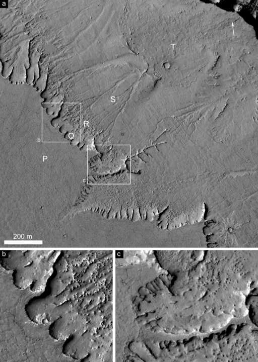
The terrain seen here appears to be composed of alternating layers of clean and dust-laden ice. Most of the surface is covered with patches of small channels. It is thought that these have been carved by vaporized ice. On Mars, the ice goes straight to a gas (a process called “sublimation”) rather than first melting. So, as the ice heats in the spring and summer, gas is generated and flows under the remaining ice. This flowing gas can move dust and slowly carve a small channels.

The lander was to touch down on the southern polar layered terrain, between 73°S and 76°S in the region, Planum Australe less than 1,000 km from the south pole, near the edge of the carbon dioxide ice cap in Mars’ late southern spring.

So what could have happened to the spacecraft? It has been speculated that either the thrusters failed as it began to land. Or perhaps the landing sequence failed entirely, and when the legs were deployed the software accidently reported that the lander was on the ground, cutting the parachute while the lander was actually hundreds of feet in the air. Bummer.

But the only way to know for sure it to find the remains of the spacecraft. So let’s get searching! And watch for more images from HiRISE to look for the lost MPL.

Source: HiRISE

Going to Mars Together

Mars. Credit: NASA

[/caption]
From the “this makes complete sense” department: NASA and ESA have established an initiative to make future explorations of Mars a joint venture. The ESA Director of Science and Robotic Exploration, David Southwood, met with NASA’s Associate Administrator for Science, Ed Weiler at the end of June and created the Mars Exploration Joint Initiative (MEJI) that will provide a framework for the two agencies to define and implement their scientific, programmatic and technological goals at Mars. The initiative includes launch opportunities in 2016, 2018 and 2020, with landers and orbiters conducting astrobiological, geological, geophysical and other high-priority investigations, leading up to a sample return mission in the 2020s.

Both NASA and ESA have been reassessing their Mars exploration programs, and Weiller revealed at a press conference last year (when it was announced that the Mars Science Laboratory would be delayed) that NASA and ESA would seek to work together. But now it is official.

The two space agencies will be working together to plan future missions. A joint architecture review team will be established to assist the agencies in planning the mission portfolios. As plans develop, they will be reviewed by ESA member states for approval and by the US National Academy of Sciences.

Source: ESA

Perchlorates and Water Make for Potential Habitable Environment on Mars

This mosaic assembled from Phoenix images show the spacecraft's three landing legs. Splotches of Martian material on the landing leg strut at left could be liquid saline-water. Click for larger version on Spaceflightnow. com Credit: Kenneth Kremer, Marco Di Lorenzo, NASA/JPL/UA/Max Planck Institute and Spaceflightnow.com. Used by permission

[/caption]
Scientists say that the Arctic region studied by Phoenix lander may be a favorable environment for microbes. Just-right chemistry and periods where thin films of liquid water form on the surface could make for a habitable setting. “Not only did we find water ice, as expected, but the soil chemistry and minerals we observed lead us to believe this site had a wetter and warmer climate in the recent past — the last few million years — and could again in the future,” said Phoenix Principal Investigator Peter Smith of the University of Arizona, Tucson.

The Phoenix science team released four papers today after spending months interpreting the data returned by the lander during its 5-month mission.

The most surprising finding was perchlorate in the Martian soil. This Phoenix finding caps a growing emphasis on the planet’s chemistry, said Michael Hecht of from the Jet Propulsion Laboratory, who led a paper about Phoenix’s soluble-chemistry findings.

“The study of Mars is in transition from a follow-the-water stage to a follow-the-chemistry stage,” Hecht said. “With perchlorate, for example, we see links to atmospheric humidity, soil moisture, a possible energy source for microbes, even a possible resource for humans.”

Perchlorate, which strongly attracts water, makes up a few tenths of a percent of the composition in all three soil samples analyzed by Phoenix’s wet chemistry laboratory. It could pull humidity from the Martian air. At higher concentrations, it might combine with water as a brine that stays liquid at Martian surface temperatures. Some microbes on Earth use perchlorate as food. Human explorers might find it useful as rocket fuel or for generating oxygen.

Close up shows splashes of material on lander leg strut. Image: Kenneth Kremer, Marco Di Lorenzo, NASA/JPL/UA/Max Planck Institute.  Used by permission.
Close up shows splashes of material on lander leg strut. Image: Kenneth Kremer, Marco Di Lorenzo, NASA/JPL/UA/Max Planck Institute. Used by permission.

A paper about Phoenix water studies, led by Smith, cites clues supporting an interpretation that the soil has had films of liquid water in the recent past. The evidence for water and potential nutrients “implies that this region could have previously met the criteria for habitability” during portions of continuing climate cycles, these authors conclude.

Phoenix dug down with its scoop and found ice just under the surface of Mars. “We wanted to know the origin of the ice,” Smith said. “It could have been the remnant of a larger polar ice cap that shrank; could have been a frozen ocean; could have been a snowfall frozen into the ground. The most likely theory is that water vapor from the atmosphere slowly diffused into the surface and froze at the level where the temperature matches the frost point. We expected that was probably the source of the ice, but some of what we found was surprising.”

Evidence that the ice in the area sometimes thaws enough to moisten the soil comes from finding calcium carbonate in soil heated in the lander’s analytic ovens or mixed with acid in the wet chemistry laboratory. Another paper from a team led by University of Arizona’s William Boynton report that the amount of calcium carbonate “is most consistent with formation in the past by the interaction of atmospheric carbon dioxide with liquid films of water on particle surfaces.”

This mosaic of images from the Surface Stereo Imager camera on NASA's Phoenix Mars Lander shows several trenches dug by Phoenix, plus a corner of the spacecraft's deck and the Martian arctic plain stretching to the horizon. Image Credit: NASA/JPL-Caltech/University of Arizona/Texas A&M University

The new reports leave unsettled whether soil samples scooped up by Phoenix contained any carbon-based organic compounds. The perchlorate could have broken down simple organic compounds during heating of soil samples in the ovens, preventing clear detection.

The heating in ovens did not drive off any water vapor at temperatures lower than 295 degrees Celsius (563 degrees Fahrenheit), indicating the soil held no water adhering to soil particles. Climate cycles resulting from changes in the tilt and orbit of Mars on scales of hundreds of thousands of years or more could explain why effects of moist soil are present.

Phoenix launched in August 2007and landed in May, 2008. Phoenix ended communications in November 2008 as the approach of Martian winter depleted energy from the lander’s solar panels.

Sources: JPL, EurekAlert, Spaceflightnow.com

Phoenix Lander Team: It Snows at Night on Mars

Data from the Phoenix lander's LIDAR instrument showing precipitation falling on Mars. Credit: Whiteway, et al.

[/caption]
It snows on Mars. This occurs, at least in the northern arctic region where the Phoenix lander set up camp in 2008. Science teams from Phoenix were able to observe water-ice clouds in the Martian atmosphere and precipitation that fell to the ground at night and sublimate into water in the morning. James Whiteway and his colleagues say that clouds and precipitation on Mars play a role in the exchange of water between the ground and the atmosphere and when conditions are right, snow falls regularly on Mars.

“Before Phoenix we did not know whether precipitation occurs on Mars,” Whiteway said. “We knew that the polar ice cap advances as far south as the Phoenix site in winter, but we did not know how the water vapor moved from the atmosphere to ice on the ground. Now we know that it does snow, and that this is part of the hydrological cycle on Mars.”

Phoenix landed at the north arctic region on Mars (68.22°N, 234.25°E) on May 25th, 2008. On Mars, this was just before the summer solstice. Phoenix operated for 5 months, and was able to observe conditions as the seasons changed from summer to winter, giving science teams an unprecedented look at the planet’s changing weather patterns, including frost and precipitation.

The science team used the light detection and ranging instrument, known as LIDAR, and observed clouds that are similar to cirrus clouds here on Earth.

The LIDAR instrument emits pulses of laser light upward into the atmosphere, and then detects the backscatter from dust and clouds. The researchers were able to observe that water-ice crystals grow large enough to precipitate through the atmosphere at night and sublimate into water in the morning. The water vapor on the ground is then mixed back up through the air by turbulence and convection – reaching a height of about two and a half miles (four kilometers) – before again forming clouds at night.

Movie of clouds on Mars. Credit: NASA/JPL/UofA

Fall streaks in the cloud structure traced the precipitation of ice crystals toward the ground.

“Frost was predicted, but snowfall was quite a welcome surprise,” said Phoenix principal investigator Peter Smith. “In summer there was a lot of dust in the atmosphere. As we neared fall, the dust cleared, and all of a sudden there were water ice clouds forming at about 4 km (2.5 mi.) above the surface. We could see the clouds scud by, moving through the camera field, and once we saw snow coming out of the bottom of a cloud. It was very exciting to watch the daily weather changes. No one has ever had this experience.”

Using the LIDAR, the team could measurement atmospheric dust in the planetary boundary layer (PBL), the lowest part of the atmosphere which is directly influenced by its contact with a planetary surface.

Whiteway and his team said the PBL on Mars is quite interesting. “The PBL on Mars was well mixed, up to heights of around 4 kilometers, by the summer daytime turbulence and convection,” the team wrote in their paper, which is published today in the Journal Science. “The water-ice clouds were detected at the top of the PBL and near the ground each night in late summer after the air temperature started decreasing. The interpretation is that water vapor mixed upward by daytime turbulence and convection forms ice crystal clouds at night that precipitate back toward the surface.”

The clouds didn’t begin forming until around sol 80 or 90 – the number of days from when Phoenix landed on Mars — when air temperatures were cool enough for water vapor in the atmosphere to condense. In the early morning hours on sol 109, the LIDAR observed clouds and precipitation that extended all the way to the ground.

The science team said the clouds and precipitation keep the water confined within the PBL. Eventually, the ice clouds would have persisted within the PBL throughout the daytime, and water ice would have remained deposited on the ground. As the depth of the PBL decreased in late summer, the atmospheric water vapor would decrease, and the process would eventually stop as winter progressed.

Source: Science

Test-Bed Rover is Now Stuck — Which is a Good Thing!

With a slope of about 10 degrees and a pointy rock under the test rover's belly, this sandbox setup at NASA's Jet Propulsion Laboratory, Pasadena, Calif., is ready for engineers to use the test rover to assess possible moves for getting Mars rover Spirit out of a patch of loose Martian soil. Credit: JPL

[/caption]
Engineers at the Jet Propulsion Laboratory have intentionally driven their engineering rover into soft soil in a sandbox testbed, to simulate how the Spirit rover is stuck on Mars. And they did a good job of it, too, as the test rover, called SSTB1, is stuck, as well, with its wheels spinning and going nowhere. The science team has confirmed a rock on Mars, underneath Spirit is touching the underside of the rover, so engineers have placed a similar looking rock in the test sandbox, as seen above.

“We want to experiment with different extraction techniques down here on Earth before we actually do them for real on Mars,” said John Callas, project manager for the Mars rovers. “Our expectation is that it will some time to get Spirit out, so we will be able to get a better feel for that here in this facility to see how well the techniques work and how long it will take for them to work.”

The rover team spent several days of preparing a sloped area of soft, fine soil to simulate Spirit’s current sandtrap on Mars. On June 30 they maneuvered the test rover around, driving the wheels to the loose soil where the rover would sink and slide to the side, with a slope of about 10 degrees, as engineers believe Spirit has done on Mars.

You can follow the work being done to free Spirit from her predicament at the Free Spirit website. JPL regularly posts updates and videos showing what the rover teams are doing, and currently you can see a movie of how the test rover was driven in the sandbox to get stuck.

A test rover rolls off a plywood surface into a prepared bed of soft soil.  Credit: JPL
A test rover rolls off a plywood surface into a prepared bed of soft soil. Credit: JPL

There are actually two test vehicles, and the folks at UnmannedSpaceflight.com have a page explaining the differences, as well as other FAQs about the attempts to free Spirit. The one being use for this current test, SSTB1 is a full size replica of the MER vehicles, but it has a few differences such as no solar panels, and a few other minor missing parts. It has the same mass as the ones on Mars, which means it has a higher weight on Earth than the MERs have on Mars.

The other test rover, SSTB Lite, is a stripped down vehicle with same wheel size, actuators and suspension system, but has other major components missing which gives it a weight on Earth that is similar to the weight of MER on Mars. However, when the Opportunity rover was stuck a couple of years in the Purgatory dune, engineers found that SSTB1 behaved more similarly to the MER vehicles, possibly because both the SSTB1 and the soil were subject to the same gravity vector.

Mosaic of the area around Home Plate where Spirit remains stuck was made especially for Spaceflight Now (Used by permission).  Credit: Kenneth Kremer, Marco DiLorenzo, NASA/JPL/Cornell/Spaceflight Now.  Click for larger image.
Mosaic of the area around Home Plate where Spirit remains stuck was made especially for Spaceflight Now (Used by permission). Credit: Kenneth Kremer, Marco DiLorenzo, NASA/JPL/Cornell/Spaceflight Now. Click for larger image.

So, just where is Spirit on Mars? Take a look at this great image created by Ken Kremer and Marco DeLorenzo of UnmannedSpaceflight.com, showing Spirit’s current location. It shows smooth area in the foreground, that concealed slippery water related sulfate material where rover became stuck. Once free, Spirit will drive to area near the unusually capped hill ahead designated Von Braun to sample water related evidence there. Let’s hope the engineer’s work here on Earth will “Free Spirit” and enable explorations of Von Braun, and beyond.

Caption for mosaic above: Mosaic of the area around Home Plate where Spirit remains stuck was made especially for Spaceflight Now (Used by permission). Credit: Kenneth Kremer, Marco DiLorenzo, NASA/JPL/Cornell/Spaceflight Now. Click the picture for a larger image.

Sources: “Free Spirit” website, Unmanned Spaceflight, Spaceflightnow.com

Mars Will NOT Look as Big as the Full Moon, But You Can Watch it Get Closer

Mars and the Moon -- NOT. Credit: Scientific American

[/caption]

For criminy’s sake, I just got one of those “Mars as big as the full Moon in August” emails. For one more time: this is completely false and it couldn’t possibly happen. Besides, in 2009 Mars is all but unobservable until the end of the year, and even next year it won’t be much better. So can we please see an end to these erroneous emails???

But Mars is coming closer to Earth (it happens like clockwork every 26 months) and the folks at Emory University have created a real-time distance calculator that shows Mars’ geocentric distance from us. It’s really fun to see how quickly Mars is coming closer to Earth (but pleeeeease it is not going to look as big the full Moon!!!) The distance is calculated in miles (sorry rest of the world) and shows up in blue when Mars is approaching and red when Mars begins to move farther from Earth. Very fun!

And if you need to know why Mars will not look as big as the full moon, see below.

Even at its closest approach, which happened back in 2003, Mars was 35 million miles (56 million km) away from Earth. You would have to magnify Mars 75 times to make it look as big as the full Moon, without a telescope. Mars won’t come this close again until 2287.

Here’s a graph from Robin Scagell at Popular Astronomy (below) which shows how the distance from Earth to Mars varies over the next few decades, shown as the size that Mars will appear in the sky. 25 arc seconds is about half the apparent size of Jupiter in the sky, which is the largest that Mars appeared in 2003.

Apparitions of Mars 2003-2042.  Credit:  Popular Astronomy
Apparitions of Mars 2003-2042. Credit: Popular Astronomy

Mars as big as the full moon just ain’t gonna happen, folks.

We’ve discussed the Mars Hoax email every years since 2003. Here are the UT articles for 2008, 2007, 2006, and 2005. And if you need more there are a few from Phil Plait the Bad Astronomer: here, here , here, and here’s the original one back in 2003.

And while I’m at it, I also recently got a “North Pole at Sunset” email. Another NOT.

Landforms Indicate “Recent” Warm Weather on Mars

Retrogressive scarps with cuspate niches, long branching spurs and associated fluvial-like tributary channels. Credit:NASA/JPL/UofA

[/caption]
Remember the polygon-shaped landforms at Mars north polar region that the Phoenix lander studied? The polygons are produced by seasonal expansion and contraction of ground ice, and these shapes have been found in other regions on Mars as well. New studies of images from the HiRISE camera on the Mars Reconnaissance Orbiter indicates that the Martian surface near the equator experienced freeze-thaw cycles as recently as 2 million years ago. This means Mars had significantly warmer weather in its recent past, and has not been locked in permafrost conditions for billions of years as had been previously thought.

The HiRISE images show polygon-patterned surfaces, branched channels, blocky debris and mound/cone structures.

Dr. Matthew Balme, from The Open University, made the new discovery by studying detailed images of equatorial landforms that formed by melting of ice-rich soils, such as the polygons, branched channels, blocky debris and mound/cone structures. These are all found in an outflow channel, thought to have been active as recently as 2 million to 8 million years ago. Since the landforms exist within, and cut across, the pre-existing features of the channel, this suggests that they, too, were created within this timeframe.

Full resolution view of domed polygons from HiRISE.  Credit: NASA/JPL/U of A
Full resolution view of domed polygons from HiRISE. Credit: NASA/JPL/U of A

All of these features are similar to landforms on Earth typical of areas where permafrost terrain is melting.

“The features of this terrain were previously interpreted to be the result of volcanic processes,” said Balme. “The amazingly detailed images from HiRISE show that the features are instead caused by the expansion and contraction of ice, and by thawing of ice-rich ground. This all suggests a very different climate to what we see today.”

This also means as the shorter the time period since the last warm weather on the planet, the better the chance that any organisms that may have lived in warmer times are still alive under the planet’s surface.

“These observations demonstrate not only that there was ice near the Martian equator in the last few million years, but also that the ice melted to form liquid water and then refroze,” said Balme. “And this probably happened for many cycles. Given that liquid water seems to be essential for life, these kinds of environments could be a great place to look for evidence of past life on Mars.”

Source: STFC

Spirit Rover Begins Making Night Sky Observations

The bright streak is the star Canopus. Credit: NASA/JPL

[/caption]

When your rover has abundant energy but can’t go anywhere, what’s a scientist to do? How about making observations of the evening and night skies on Mars? With the benefit of a boost in electrical power from a wind gust cleaning off her solar panels, the Spirit rover has more energy available than she’s had for a couple of years. But unfortunately, Spirit is stuck in a patch of loose soil in the Home Plate region on Mars. While the engineers at JPL work hard at figuring out how to “Free Spirit” (see the new website dedicated to their efforts) scientists are making observations of her surroundings to aid in the effort to get her out. But there’s also enough power to do additional observations, and astronomy was a logical choice. “Certainly, a month or more ago, no one was considering astronomy with the rovers,” said Mark Lemmon, planetary scientist at Texas A&M University and member of the rover team. “We thought that was done. With the dust cleanings, though, everyone thinks it is better to use the new found energy on night time science than to just burn it with heaters.” Besides, Lemmon added, using all the energy in the daytime might lead to overheating.

The image above was taken on Spirit’s sol 1943 (June 22 on Earth)showing the night sky above her location.

But most of the “stars” in this raw image are not really stars, just hot pixels. “We use long and multiple exposures to make stars stand out,” Lemmon told Universe Today. “We can only see bright stars, looking through the dust, but can pick out most of the major stars in Orion for instance.”

But a star is visible in this image. “That streak in the 1943 images is the bright star Canopus,” said Jim Bell, planetary scientist at Cornell University and lead for the rovers’ Pancam team. “We’re monitoring stars to search for evidence of night-time clouds, fog, and hazes.  We’re also occasionally trying to image Earth and Venus as they set in the west after sunset.  We’ve had some success, but the twilight sky is so bright we’re still working on tweaking the exposure times.”

Of course, this isn’t the first time Spirit has done astronomy on Mars. She also made night sky observations back in 2005. In an article Bell wrote for Sky and Telescope in 2006 he described Spirit’s astronomy as “stone-knives and bear-skins backyard astronomy–but from Mars!” And certainly, this is exciting to have an additional opportunity to make astronomical observations from the surface of another world.

Spirit's twilight observations from sol 1947. Credit: NASA/JPL


Bell added that the current astronomy campaign with Spirit has many similarities with the one four years ago, and Lemmon said they are focusing on a few different goals for looking at the twilight and night skies.

“The Canopus images may become a regular occurrence, as a way to monitor dust and/or ice in the sky at night–much as we use Sun images in the day,” Lemmon said. “For something like that, we can pick an aim (Canopus, Orion, etc.) and choose filters. We might use color filters to look for any differences that show up, or the clear filter for the most sensitive measurement. Star exposures can go up to 5.5 minutes (compare to 0.1-0.5 sec for a normal day image). We cannot track stars, so they trail after 10 seconds or so–as you see Canopus doing. In longer exposures, hot pixels and cosmic rays show up as points or cluster of light.”

Lemmon said attempting to image Earth and Venus has been challenging. “We’ve imaged both before, farther from the Sun. They are in the twilight, limiting the exposure we can use, and they are in a “bright” part of the sky.”

Lemmon added his personal favorite right now is actually the twilight imaging — not looking at stars but at how fast the twilight glow fades after sunset. “That is proving to be quite helpful in terms of understanding the distribution of dust in the atmosphere –which is closely tied to how weather works on Mars,” he said.

In 2005, the Pancam team was able to capture images of Mars’ two moons, Phobos and Deimos. “They are much brighter and let us use more filters if desired. We may pick this up again. I’m a fan of eclipse imaging, so we would need several quick images to see how fast the moon fades as sunlight is blocked by dust around Mars.”

The moons should start becoming more visible soon, and Lemmon said they will continue to take more images of Canopus and maybe other star fields. The team is not specifically looking for meteors or the orbiters around Mars, but there’s always the prospect of something fascinating showing up on future images.

“We’ve taken some recent images I hope will have new, interesting things in them,” Lemmon said. “But they are still on board the rover so we’ll have to wait and see what they show later.”

Stay tuned!

Link to Spirit’s raw images.

Webpage on Spirit’s 2005 astronomical imaging.

Sources: email exchanges with Mark Lemmon and Jim Bell

Rover Update With Video

Image from Spirit's front hazcam from sol 1940. Credit: NASA/JPL

[/caption]
Here’s a rover update: Spirit remains stuck in her location on the west side of Home Plate, and work continues at JPL for testing on how to extract the rover from being embedded in soft soil. A rock may be underneath Spirit, keeping her from moving, but more images are being taken by the microscopic camera at the end of the robotic arm to try and determine exactly what is going on under and around the rover. But with a boosted power supply, Spirit has also been busy making scientific observations of her surroundings. And one more thing, which would be extremely fun, rover driver Scott Maxwell hinted on Twitter that Spirit has so much power now from a recent wind event that cleared off her solar panels that she may attempt to make overnight observations. So stay tuned for PANCAM images of the Martian night sky!

Enjoy this video update on the Mars Exploration rovers by another rover driver, Ashley Stroupe.

As of Sol 1932 (June 9, 2009), Spirit’s solar array energy production is at 828 watt-hours. Total odometry remains at 7,729.93 meters (4.80 miles).

Meanwhile over on the other side of the planet, Opportunity continues to drive south on the way to Endeavour crater. On Sol 1906 (June 4, 2009), the rover completed a 69-meter (266-foot) drive due south. Elevated actuator currents with the right-front wheel continue to cause concern. On Sol 1910 (June 8, 2009), the planned drive stopped early because a multi-wheel current limit threshold was exceeded. A diagnostic maneuver on the next sol was successful indicating the cause on the previous sol was due to the elevated right-front wheel motor currents.

The view from Opportunity on sol 1912.  Credit: NASA/JPL
The view from Opportunity on sol 1912. Credit: NASA/JPL


A long, backward drive was performed on Sol 1912 (June 10, 2009). Driving backwards is one technique to mitigate the elevated wheel currents. However, wheel currents continued to be elevated after that 72-meter (236-foot) drive. Further resting of the rover’s actuators is being considered.

The plan ahead includes opening the shroud of the miniature thermal emission spectrometer (Mini-TES) to expose the instrument’s dust-contaminated elevation mirror to the environment. This is an attempt to allow the wind environment to clean dust off the mirror.

As of Sol 1912 (June 10, 2009), Opportunity’s solar array energy production is 431 watt-hours. Opportunity’s total odometry is 16,569.05 meters (10.3 miles).

Lightning Detected on Mars

An illustration of a dust storm on Mars. Credit: Brian Grimm and Nilton Renno

[/caption]
The first direct evidence of lightning has been detected on Mars. Researchers from the University of Michigan found signs of electrical discharges during dust storms on the red planet using an innovative microwave detector . The bolts were dry lightning, said Professor Chris Ruf. “What we saw on Mars was a series of huge and sudden electrical discharges caused by a large dust storm. Clearly, there was no rain associated with the electrical discharges on Mars. However, the implied possibilities are exciting.”

The Space Physics Research Laboratory at the University of Michigan developed the kurtosis detector, which is capable of differentiating between thermal and non-thermal radiation. The device took measurements of microwave emissions from Mars for approximately five hours a day for 12 days between May 22 and June 16, 2006.

On June 8, 2006 both an unusual pattern of non-thermal radiation and an intense Martian dust storm occurred, the only time that non-thermal radiation was detected. Non-thermal radiation would suggest the presence of lightning.

Electric activity in Martian dust storms has important implications for Mars science, the researchers said.
“It affects atmospheric chemistry, habitability and preparations for human exploration. It might even have implications for the origin of life, as suggested by experiments in the 1950s,” said Professor Nilton Renno of the university’s Department of Atmospheric, Oceanic and Space Sciences.

“Mars continues to amaze us,” said Michael Sanders, manager of exploration systems and technology at the National Aeronautics and Space Administration’s Jet Propulsion Laboratory and a researcher involved in the study. “Every new look at the planet gives us new insights.”

The new findings are to appear in an upcoming issue of the journal Geophysical Research Letters.

Source: University of Michigan