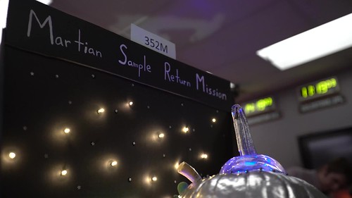
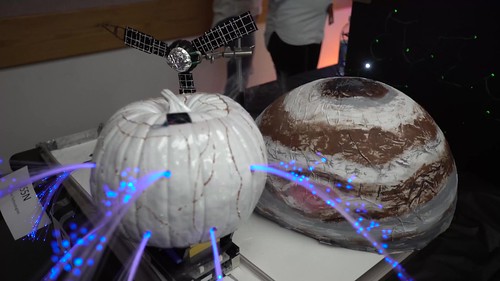
The 6th annual pumpkin carving at the Jet Propulsion Laboratory included this 'Mars sample return pumpkin.' Credit: JPL.
Every workplace should have this much fun! A group of engineers at the Jet Propulsion Laboratory held their sixth annual pumpkin carving contest, and this year’s entries did not disappoint. Using a combination of engineering savvy and creative license, the JPL engineers carved up several different types of themed pumpkins, including a cow abduction by aliens, a geyser-spewing Europa, unique depictions of several different space missions and much more.
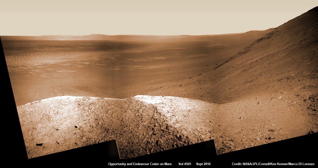
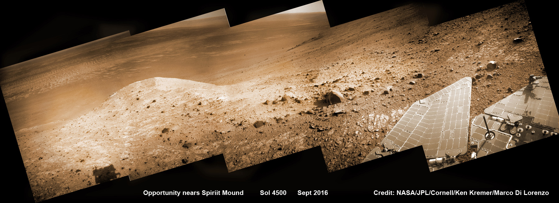
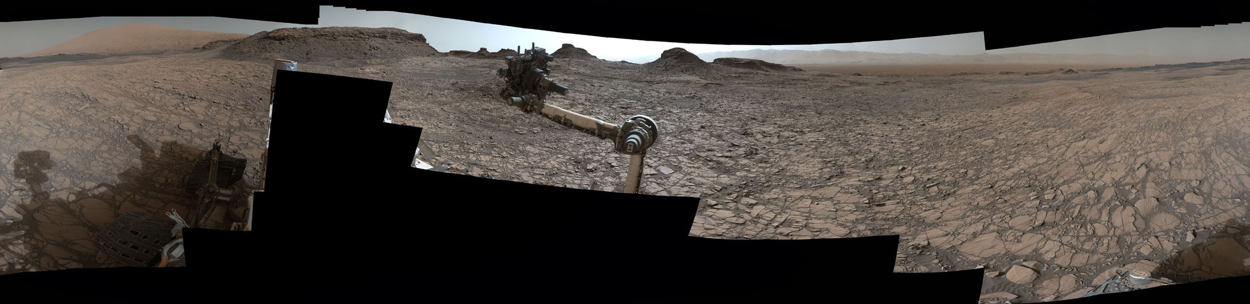
NASA’s Opportunity explores Spirit Mound after descending down Marathon Valley and looks out across the floor of vast Endeavour crater. This navcam camera photo mosaic was assembled from raw images taken on Sol 4505 (25 Sept 2016) and colorized. Credit: NASA/JPL/Cornell/ Ken Kremer/kenkremer.com/Marco Di Lorenzo
NASA’s Opportunity explores Spirit Mound after descending down Marathon Valley and looks out across the floor of vast Endeavour crater. This navcam camera photo mosaic was assembled from raw images taken on Sol 4505 (25 Sept 2016) and colorized. Credit: NASA/JPL/Cornell/ Ken Kremer/kenkremer.com/Marco Di Lorenzo
And as we are fond of reporting – the best is yet to come. After experiencing 4500 Martian sunsets, Opportunity has been granted another mission extension and she is being targeted to drive to an ancient gully where life giving liquid water almost certainly once flowed on our solar systems most Earth-like planet.
See Opportunity’s current location around ‘Spirit Mound” – illustrated in our new photo mosaic panoramas above and below.
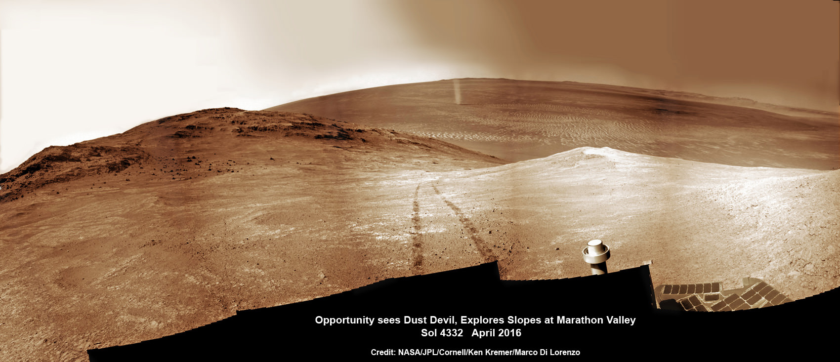
NASA’s Opportunity rover scans ahead to Spirit Mound and vast Endeavour crater as she celebrates 4500 sols on the Red Planet after descending down Marathon Valley. This navcam camera photo mosaic was assembled from raw images taken on Sol 4500 (20 Sept 2016) and colorized. Credit: NASA/JPL/Cornell/ Ken Kremer/kenkremer.com/Marco Di Lorenzo
Opportunity was launched on a Delta II rocket from Cape Canaveral Air Force Station in Florida on July 7, 2003.
“We have now exceeded the prime-mission duration by a factor of 50,” noted Opportunity Project Manager John Callas of NASA’s Jet Propulsion Laboratory, Pasadena, California.
“Milestones like this are reminders of the historic achievements made possible by the dedicated people entrusted to build and operate this national asset for exploring Mars.”
The newest 2 year extended mission phase just began on Oct. 1 as the rover was stationed at the western rim of Endeavour crater at the bottom of Marathon Valley at a spot called “Bitterroot Valley.”
And at this moment, as Opportunity reached and surpassed the 4500 Sol milestone, she is investing an majestic spot dubbed “Spirit Mound” – and named after her twin sister “Spirit” – who landed 3 weeks earlier!
This scene from the panoramic camera (Pancam) on NASA’s Mars Exploration Rover Opportunity shows “Spirit Mound” overlooking the floor of Endeavour Crater. The mound stands near the eastern end of “Bitterroot Valley” on the western rim of the crater, and this view faces eastward. The component images for this mosaic were taken on Sept. 21, 2016, during the 4,501st Martian day, or sol, of Opportunity’s work on Mars. Credit: NASA/JPL-Caltech/Cornell/Arizona State Univ.
Endeavour crater spans some 22 kilometers (14 miles) in diameter. Opportunity has been exploring Endeavour since arriving at the humongous crater in 2011.
Endeavour crater was formed when it was carved out of the Red Planet by a huge meteor impact billions of years ago.
But now for the first time she will explore the craters interior, after spending 5 years investigating the exterior and climbing to a summit on the rim and spending several year exploring the top before finally descending down the Marathon Valley feature to investigate clay minerals formed in water.
“The longest-active rover on Mars also will, for the first time, visit the interior of the crater it has worked beside for the last five years,” said NASA officials.
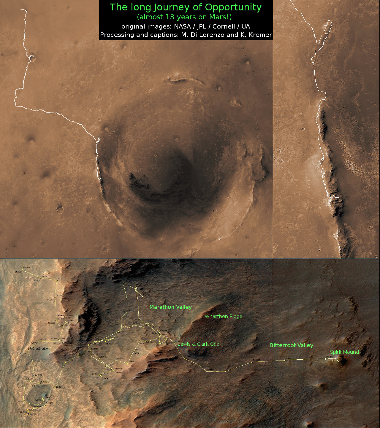
Marathon Valley measures about 300 yards or meters long. It cuts downhill through the west rim of Endeavour crater from west to east – the same direction in which Opportunity drove downhill from a mountain summit area atop the crater rim. See our route map below showing the context of the rovers over dozen year long traverse spanning more than the 26 mile distance of a Marathon runners race.
Opportunity is now being targeted to explore a gully carved out by water.
“We are confident this is a fluid-carved gully, and that water was involved,” said Opportunity Principal Investigator Steve Squyres of Cornell University, Ithaca, New York.
“Fluid-carved gullies on Mars have been seen from orbit since the 1970s, but none had been examined up close on the surface before. One of the three main objectives of our new mission extension is to investigate this gully. We hope to learn whether the fluid was a debris flow, with lots of rubble lubricated by water, or a flow with mostly water and less other material.”
Furthermore, in what’s a very exciting announcement the team “intends to drive Opportunity down the full length of the gully, onto the crater floor” – if the rover continues to function well during the two year extended mission which will have to include enduring her 8th frigid Martian winter in 2017.
And as is always the case, scientists will compare these interior crater rocks to those on the exterior for clues into the evolution, environmental and climatic history of Mars over billions of years.
“We may find that the sulfate-rich rocks we’ve seen outside the crater are not the same inside,” Squyres said. “We believe these sulfate-rich rocks formed from a water-related process, and water flows downhill. The watery environment deep inside the crater may have been different from outside on the plain — maybe different timing, maybe different chemistry.”
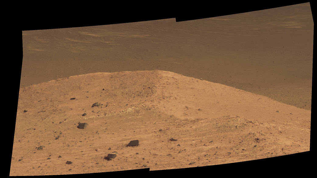
NASA’s Opportunity rover discovers a beautiful Martian dust devil moving across the floor of Endeavour crater as wheel tracks show robots path today exploring the steepest ever slopes of the 13 year long mission, in search of water altered minerals at Knudsen Ridge inside Marathon Valley on 1 April 2016. This navcam camera photo mosaic was assembled from raw images taken on Sol 4332 (1 April 2016) and colorized. Credit: NASA/JPL/Cornell/ Ken Kremer/kenkremer.com/Marco Di Lorenzo
As of today, Sol 4522, Oct 12, 2016, Opportunity has taken over 214,400 images and traversed over 26.99 miles (43.44 kilometers) – more than a marathon.
The power output from solar array energy production is currently 472 watt-hours, before heading into another southern hemisphere Martian winter in 2017.
Meanwhile Opportunity’s younger sister rover Curiosity traverses and drills into the basal layers at the base of Mount Sharp.
Stay tuned here for Ken’s continuing Earth and planetary science and human spaceflight news.
12 Year Traverse Map for NASA’s Opportunity rover from 2004 to 2016. This map shows the entire path the rover has driven on the Red Planet during more than 12 years and more than a marathon runners distance for over 4515 Sols, or Martian days, since landing inside Eagle Crater on Jan 24, 2004 – to current location at the western rim of Endeavour Crater after descending down Marathon Valley. Rover surpassed Marathon distance on Sol 3968 and marked 11th Martian anniversary on Sol 3911. Opportunity discovered clay minerals at Esperance – indicative of a habitable zone – and searched for more at Marathon Valley and is now at Spirit Mound on the way to a Martian gully. Credit: NASA/JPL/Cornell/ASU/Marco Di Lorenzo/Ken Kremer/kenkremer.com
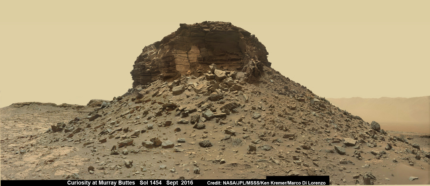
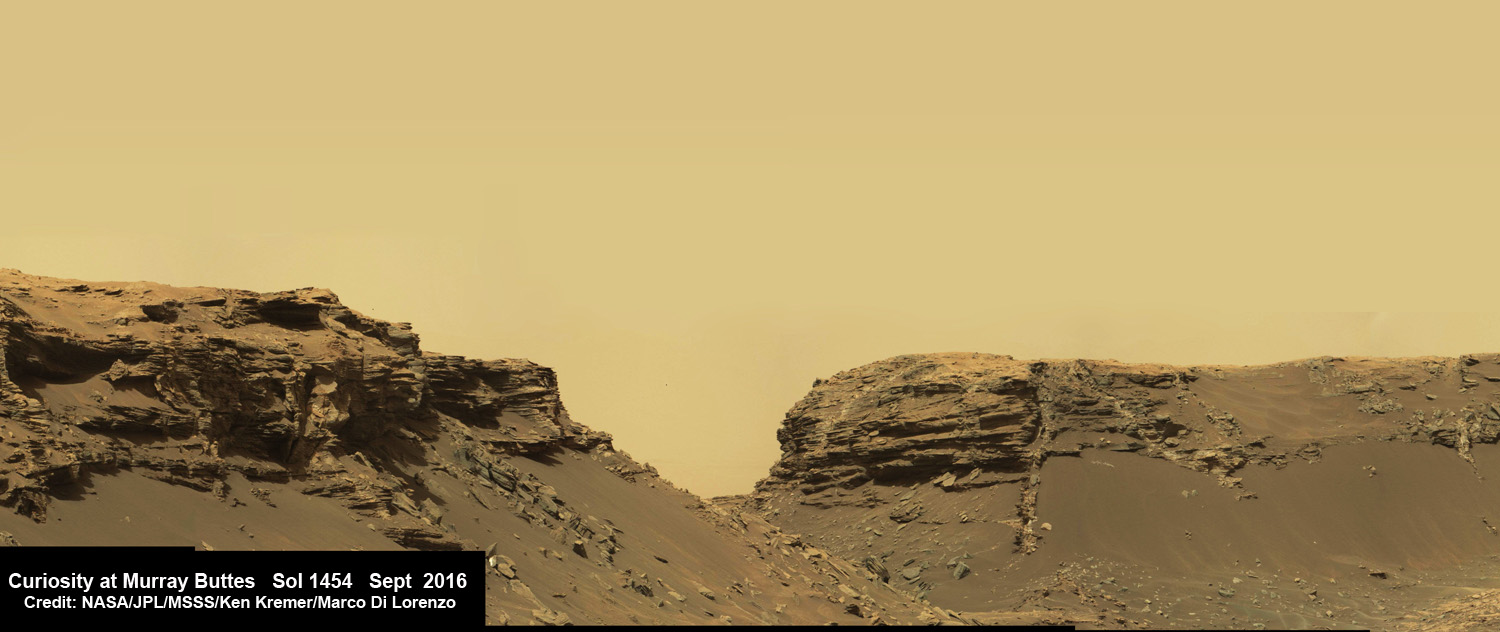
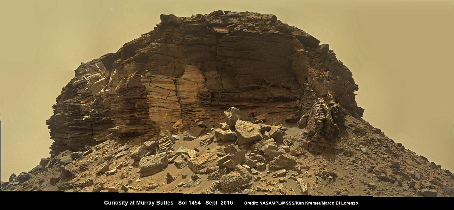
Dramatic wide angle mosaic view of butte with sandstone layers showing cross-bedding in the Murray Buttes region on lower Mount Sharp with distant view to rim of Gale crater, taken by Curiosity rover’s Mastcam high resolution cameras. This photo mosaic was assembled from Mastcam color camera raw images taken on Sol 1454, Sept. 8, 2016 and stitched by Ken Kremer and Marco Di Lorenzo, with added artificial sky. Featured at APOD on 5 Oct 2016. Credit: NASA/JPL/MSSS/Ken Kremer/kenkremer.com/Marco Di Lorenzo
Dramatic wide angle mosaic view of butte with sandstone layers showing cross-bedding in the Murray Buttes region on lower Mount Sharp with distant view to rim of Gale crater, taken by Curiosity rover’s Mastcam high resolution cameras. This photo mosaic was assembled from Mastcam color camera raw images taken on Sol 1454, Sept. 8, 2016 and stitched by Ken Kremer and Marco Di Lorenzo, with added artificial sky. Credit: NASA/JPL/MSSS/Ken Kremer/kenkremer.com/Marco Di Lorenzo
Our beyond magnificent Curiosity rover has just finished her latest Red Planet drilling campaign – at the rock target called “Quela” – into the simply unfathomable alien landscapes she is currently exploring at the “Murray Buttes” region of lower Mount Sharp. And it’s all in a Sols (or Martian Day’s) work for our intrepid Curiosity!
“These images are literally out of this world.. I don’t think I have seen anything like them on Earth!” Jim Green, Planetary Sciences Director at NASA Headquarters, Washington, D.C., explained to Universe Today.
The “Murray Buttes” region is just chock full of the most stunning panoramic vistas that NASA’s Curiosity Mars Science Laboratory rover has come upon to date. Observe and enjoy them in our exclusive new photo mosaics above and below.
“We always try to find some sort of Earth analog but these make exploring another world all worth it!” Green gushed in glee.
They fill the latest incredible chapter in her thus far four year long quest to trek many miles (km) from the Bradbury landing site across the floor of Gale Crater to reach the base region of humongous Mount Sharp.
And these adventures are just a prelude to the even more glorious vistas she’ll investigate from now on – as she climbs higher and higher on an expedition to thoroughly examine the mountains sedimentary layers and unravel billions and billions of years of Mars geologic and climatic history.
Drilling holes into Mars during the Red Planet trek and carefully analyzing the pulverized samples with the rovers pair of miniaturized chemistry laboratories (SAM and CheMin) is the route to the answer of how and why Mars changed from a warmer and wetter planet in the ancient past to the cold, dry and desolate world we see today.
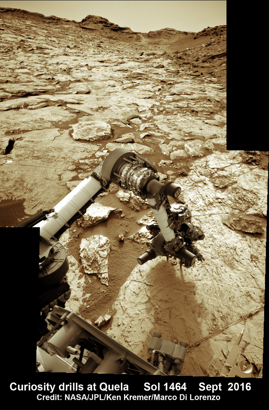
The rock target named “Quela” is located at the base of one of the buttes dubbed “Murray Butte number 12,” according to the latest mission update from Prof. John Bridges, a Curiosity rover science team member from the University of Leicester, England.
It took two tries to get the drilling done due to a technical issue, but all went well in the end and it was well worth the effort at a place never before explored by an emissary from Earth.
“The drill (successful at second attempt) is at Quela.”
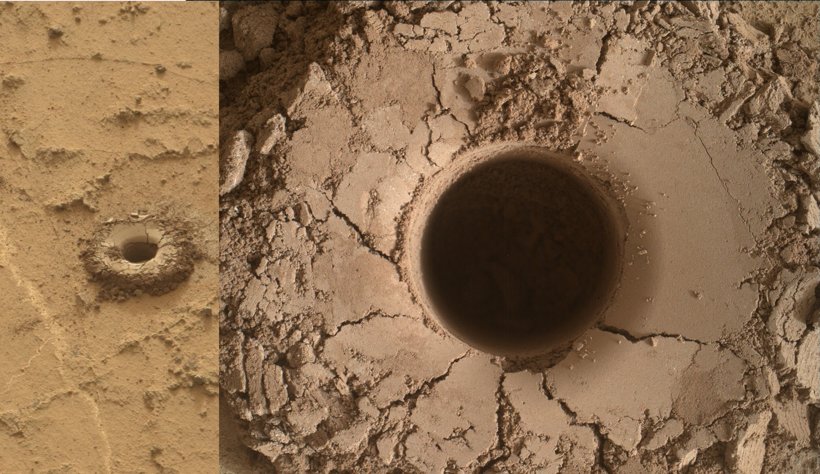
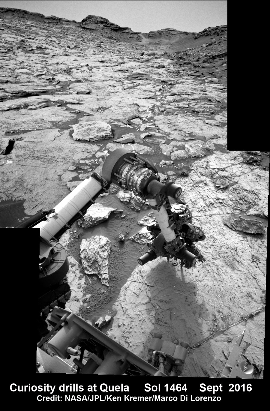
The full depth drilling was completed on Sol 1464, Sept. 18, 2016 using the percussion drill at the terminus of the outstretched 7-foot-long (2-meter-long) robotic arm – as confirmed by imaging and further illustrated in our navcam camera photo mosaic.
And that immediately provided valuable insight into climate change on Mars.
“You can see how red and oxidised the tailings are, suggesting changing environmental conditions as we progress through the Mt. Sharp foothills,” Bridges explained in the mission update.
Curiosity bore holes measure approximately 0.63 inch (1.6 centimeters) in diameter and 2.6 inches (6.5 centimeters) deep.
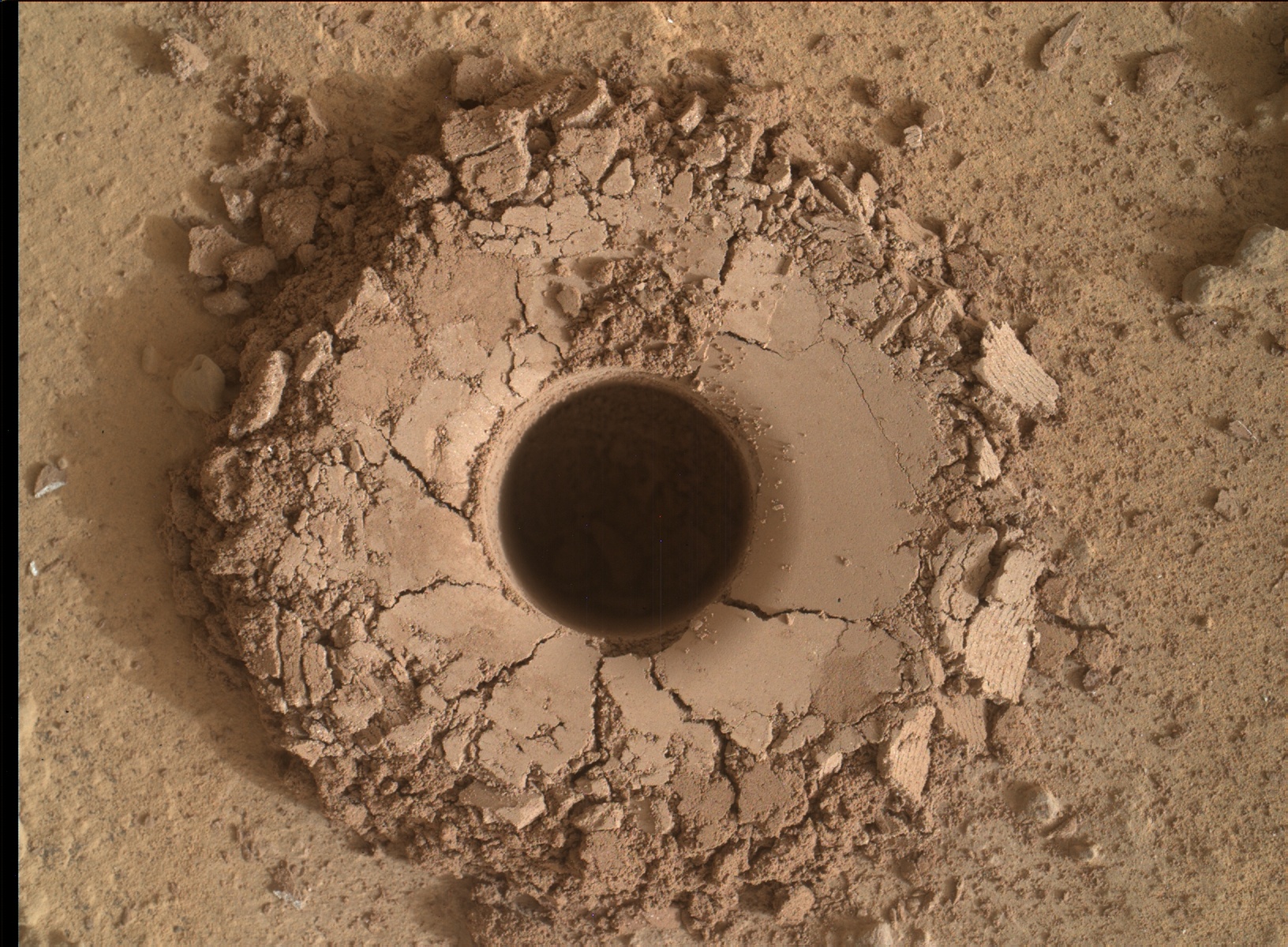
Quela drill hole bored by Curiosity rover on Sol 1464, Sept. 18, 2016 as seen in this collage of Mastcam and MAHLI raw color images taken on Sol 1465. Image Credit: NASA/JPL/MSSS. Collage: Marco Di Lorenzo/Ken Kremer
To give you the context of the Murray Buttes region and the drilling at Quela, the image processing team of Ken Kremer and Marco Di Lorenzo has begun stitching together wide angle mosaic landscape views and up close views of the drilling using raw images from the variety of cameras at Curiosity’s disposal.
The next steps after boring into Quela were to “sieve the new sample, dump the unsieved fraction, and drop some of the sieved sample into CheMin,” says Ken Herkenhoff, Research Geologist at the USGS Astrogeology Science Center and an MSL science team member, in a mission update.
“But first, ChemCam will acquire passive spectra of the Quela drill tailings and use its laser to measure the chemistry of the wall of the new drill hole and of bedrock targets “Camaxilo” and “Okakarara.” Right Mastcam images of these targets are also planned.”
“After sunset, MAHLI will use its LEDs to take images of the drill hole from various angles and of the CheMin inlet to confirm that the sample was successfully delivered. Finally, the APXS will be placed over the drill tailings for an overnight integration.”
The rover had approached the butte from the south side several sols earlier to get in place, plan for the drilling, take imagery to document stratigraphy and make compositional observations with the ChemCam laser instrument.
Curiosity drills into Quela rock target in the Murray Buttes region on Sol 1464, Sept. 18, 2016, in this navcam camera mosaic, stitched from raw images and colorized. Credit: NASA/JPL/Ken Kremer/kenkremer.com/Marco Di Lorenzo
“These are the landforms that dominate the landscape at this point in the traverse – The Murray Buttes,” says Bridges.
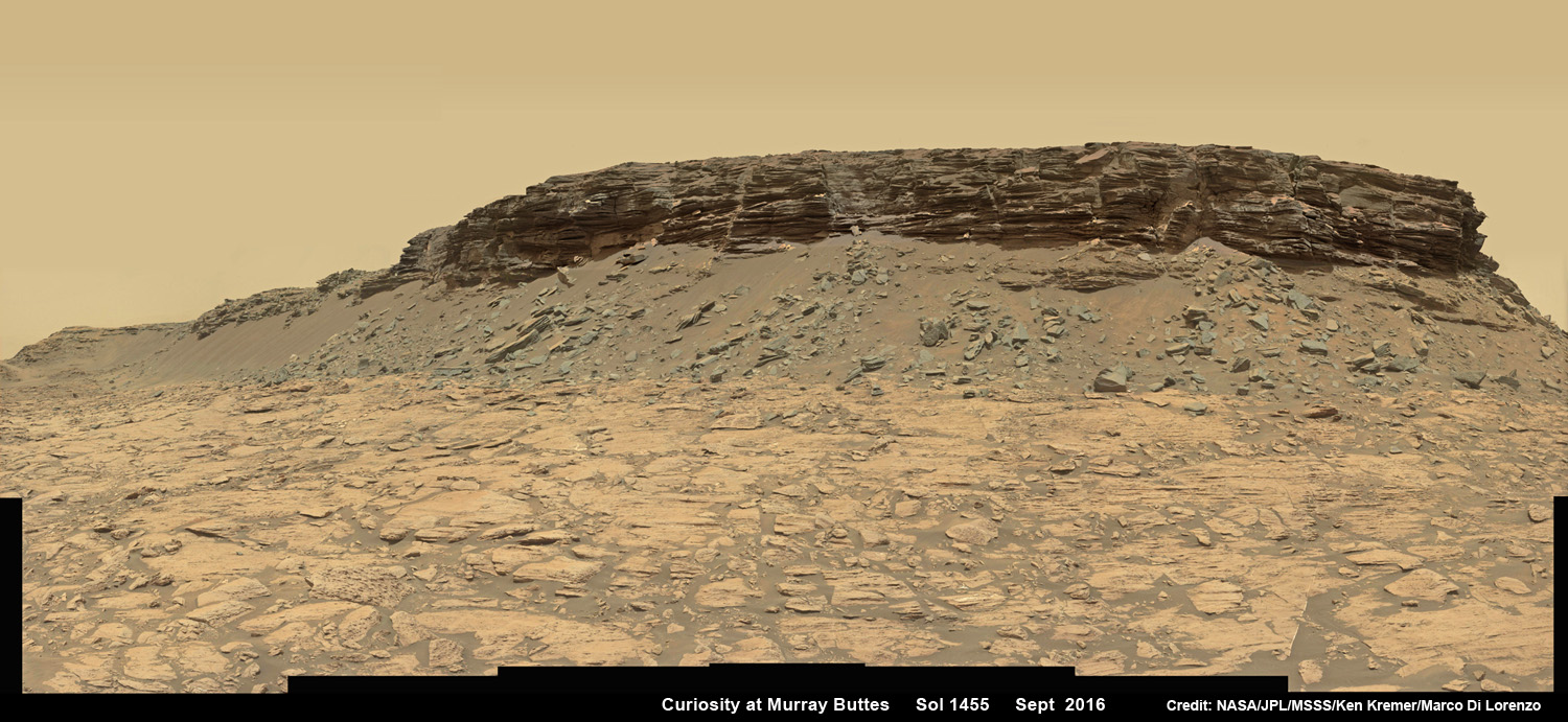
Wide angle mosaic view shows spectacular buttes and layered sandstone in the Murray Buttes region on lower Mount Sharp from the Mastcam cameras on NASA’s Curiosity Mars rover. This photo mosaic was assembled from Mastcam color camera raw images taken on Sol 1455, Sept. 9, 2016 and stitched by Marco Di Lorenzo and Ken Kremer, with added artificial sky. Credit: NASA/JPL/MSSS/Ken Kremer/kenkremer.com/Marco Di Lorenzo
What are the Murray Buttes?
“These are formed by a cap of hard aeolian rock that has been partially eroded back, overlying the Murray mudstone.”
The imagery of the Murray Buttes and mesas show them to be eroded remnants of ancient sandstone that originated when winds deposited sand after lower Mount Sharp had formed.
Scanning around the Murray Buttes mosaics one sees finely layered rocks, sloping hillsides, the distant rim of Gale Crater barely visible through the dusty haze, dramatic hillside outcrops with sandstone layers exhibiting cross-bedding.
The presence of “cross-bedding” indicates that the sandstone was deposited by wind as migrating sand dunes, says the team.
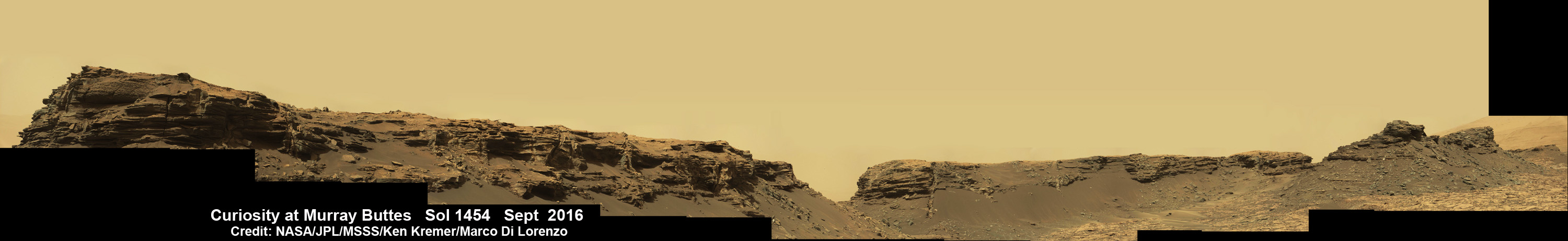
Spectacular wide angle mosaic view showing sloping buttes and layered outcrops within the Murray Buttes region on lower Mount Sharp from the Mast Camera (Mastcam) on NASA’s Curiosity Mars rover. This photo mosaic is stitched from Mastcam camera raw images taken on Sol 1454, Sept. 9, 2016 with added artificial sky. Credit: NASA/JPL/MSSS/Ken Kremer/kenkremer.com/Marco Di Lorenzo
Curiosity spent some six weeks or so traversing and exploring the Murray Buttes.
So after collecting all that great drilling data at Quela, the team is ready for even more spectacular new adventures!
“While the Murray Buttes were spectacular and interesting, it’s good to be back on the road again, as there is much more of Mt. Sharp to explore!” concludes Herkenhoff.
And the team is already commanding Curiosity to drive ahead in hot pursuit of the next drill target!
Dramatic hillside view showing sloping buttes and layered outcrops within of the Murray Buttes region on lower Mount Sharp from the Mast Camera (Mastcam) on NASA’s Curiosity Mars rover. This photo mosaic is stitched and cropped from Mastcam camera raw images taken on Sol 1454, Sept. 8, 2016, with added artificial sky. Credit: NASA/JPL/MSSS/Ken Kremer/kenkremer.com/Marco Di Lorenzo
Ascending and diligently exploring the sedimentary lower layers of Mount Sharp, which towers 3.4 miles (5.5 kilometers) into the Martian sky, is the primary destination and goal of the rovers long term scientific expedition on the Red Planet.
Curiosity rover panorama of Mount Sharp captured on June 6, 2014 (Sol 651) during traverse inside Gale Crater. Note rover wheel tracks at left. She will eventually ascend the mountain at the ‘Murray Buttes’ at right later this year. Assembled from Mastcam color camera raw images and stitched by Marco Di Lorenzo and Ken Kremer. Credit: NASA/JPL/MSSS/Marco Di Lorenzo/Ken Kremer-kenkremer.com
Three years ago, the team informally named the Murray Buttes site to honor Caltech planetary scientist Bruce Murray (1931-2013), a former director of NASA’s Jet Propulsion Laboratory, Pasadena, California. JPL manages the Curiosity mission for NASA.
As of today, Sol 1470, September 24, 2016, Curiosity has driven over 7.9 miles (12.7 kilometers) since its August 2012 landing inside Gale Crater, and taken over 355,000 amazing images.
Stay tuned here for Ken’s continuing Earth and planetary science and human spaceflight news.
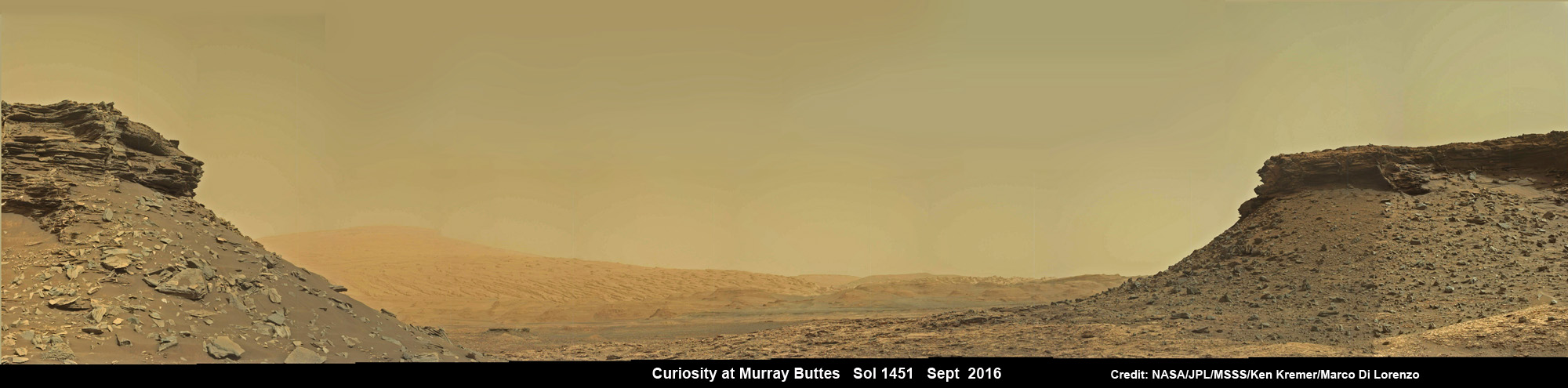
Wide angle mosaic shows lower region of Mount Sharp at center in between spectacular sloping hillsides and layered rock outcrops of the Murray Buttes region in Gale Crater as imaged by the Mast Camera (Mastcam) on NASA’s Curiosity Mars rover. This photo mosaic is stitched from Mastcam camera raw images taken on Sol 1451, Sept. 5, 2016 with added artificial sky. Credit: NASA/JPL/MSSS/Ken Kremer/kenkremer.com/Marco Di LorenzoQuela drill hole bored by Curiosity rover on Sol 1464, Sept. 18, 2016 as seen in this MAHLI arm camera raw color image taken the same Sol. Credit: NASA/JPL/MSSSCuriosity drills into Quela rock target on Sol 1464, Sept. 18, 2016 in this navcam camera mosaic. Credit: NASA/JPL/Ken Kremer/kenkremer.com/Marco Di Lorenzo
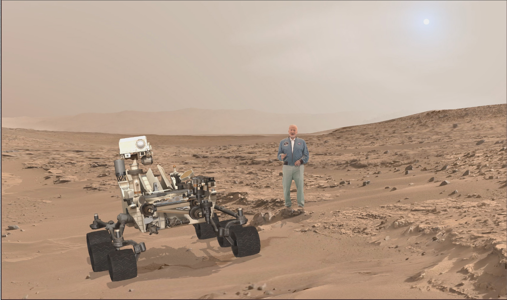
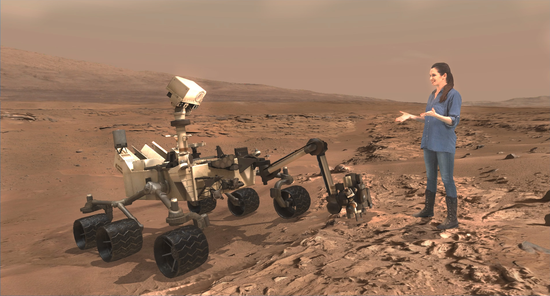
A scene from ‘Destination Mars’ of Buzz Aldrin and NASA’s Curiosity Mars rover with the Gale crater rim in the distance. The new, limited time interactive exhibit is now showing at the Kennedy Space Center visitor complex in Florida through Jan 1, 2017. Credit: NASA/JPL/Microsoft
A scene from ‘Destination Mars’ of Buzz Aldrin and NASA’s Curiosity Mars rover with the Gale crater rim in the distance. The new, limited time interactive exhibit is now showing at the Kennedy Space Center visitor complex in Florida through Jan 1, 2017. Credit: NASA/JPL/Microsoft
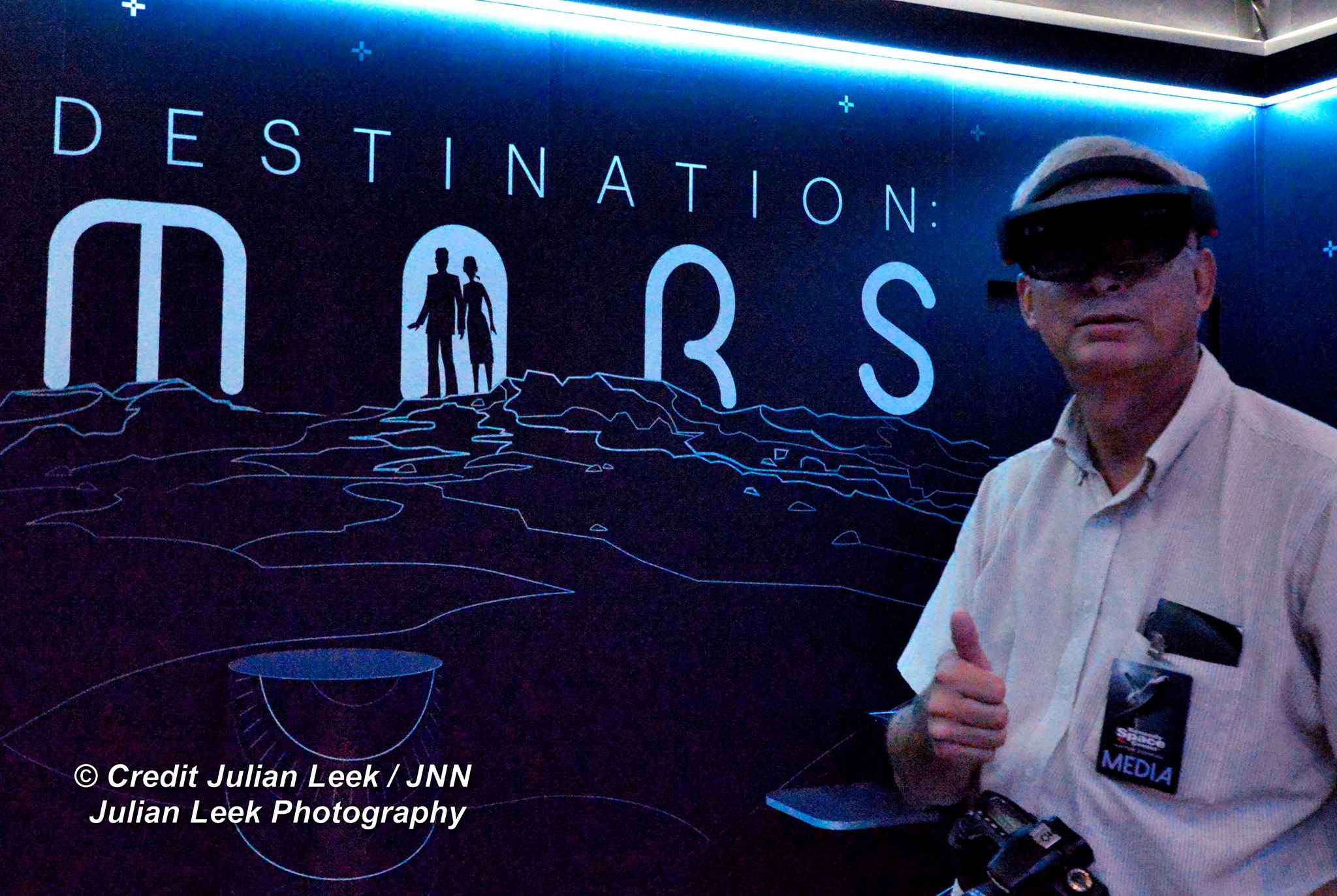
KENNEDY SPACE CENTER VISITOR COMPLEX, FL- Think a Holodeck adventure on Star Trek guided by real life Apollo 11 moonwalker Buzz Aldrin and you’ll get a really good idea of what’s in store for you as you explore the surface of Mars like never before in the immersive new ‘Destination Mars’ interactive holographic exhibit opening to the public today, Monday, Sept.19, at the Kennedy Space Center visitor complex in Florida.
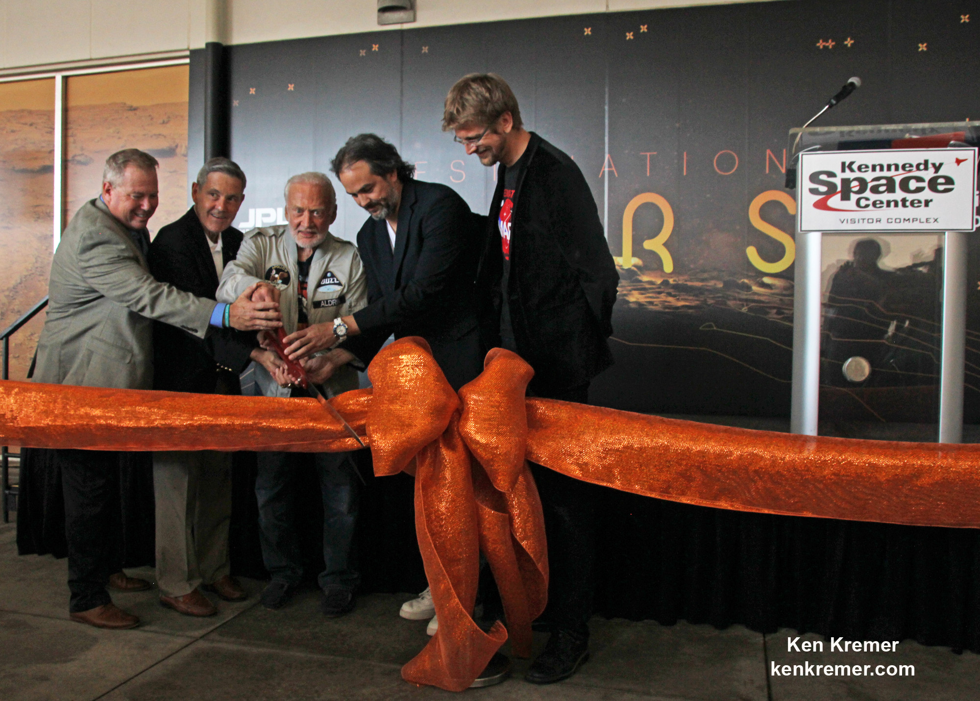
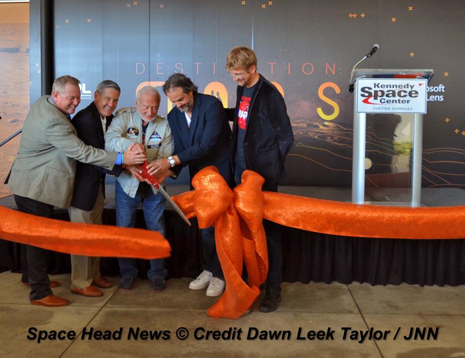
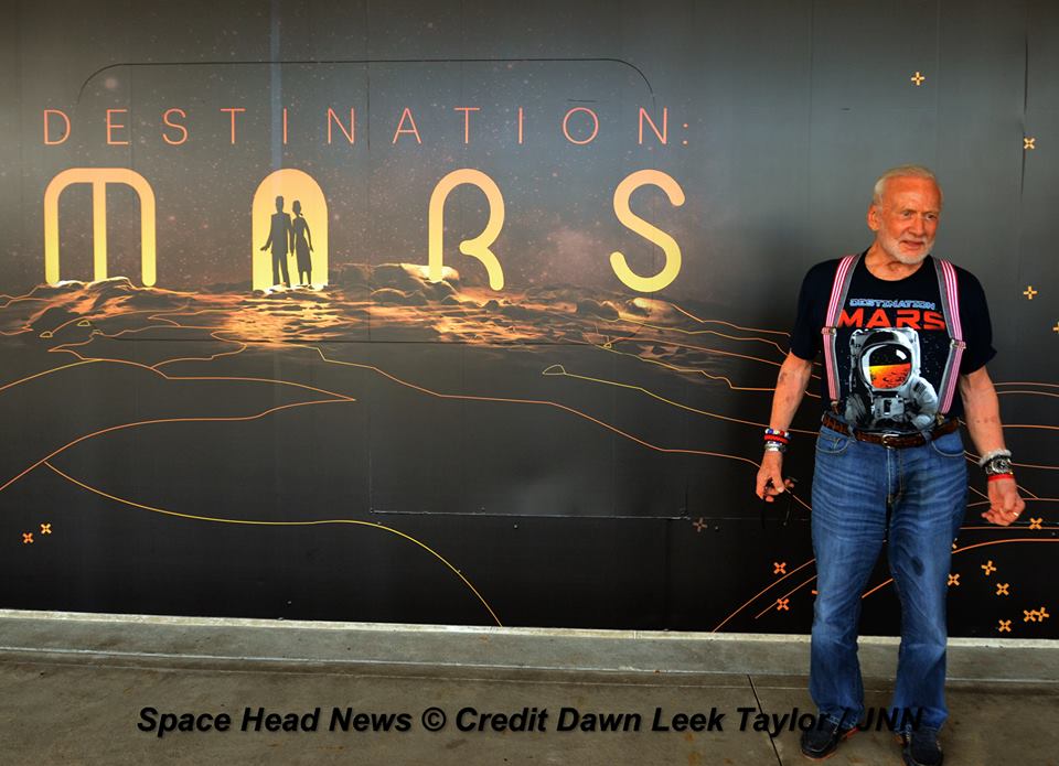
The new Red Planet exhibit was formally opened for business during a very special ribbon cutting ceremony featuring Buzz Aldrin as the star attraction – deftly maneuvering the huge ceremonial scissors during an in depth media preview and briefing on Sunday, Sept. 18, 2016, including Universe Today.
The fabulous new ‘Destination Mars’ limited engagement exhibit magically transports you to the surface of the Red Planet via Microsoft HoloLens technology.
It literally allows you to ‘Walk on Mars’ using real imagery taken by NASA’s Mars Curiosity rover and explore the alien terrain, just like real life scientists on a geology research expedition.
A ceremonial ribbon is cut for the opening of new “Destination: Mars” experience at the Kennedy Space Center visitor complex in Florida during media preview on Sept. 18, 2016. From the left are Therrin Protze, chief operating officer of the visitor complex; center director Bob Cabana; Apollo 11 astronaut Buzz Aldrin; Kudo Tsunoda of Microsoft; and Jeff Norris of NASA’s Jet Propulsion Laboratory in Pasadena, California. Credit: Ken Kremer/kenkremer.com
“Technology like HoloLens leads us once again toward exploration,” Aldrin said during the Sept. 18 media preview. “It’s my hope that experiences like “Destination: Mars” will continue to inspire us to explore.”
Destination Mars was jointly developed by NASA’s Jet Propulsion Laboratory – which manages the Curiosity rover mission for NASA – and Microsoft HoloLens.
A ceremonial ribbon is cut for the opening of new “Destination: Mars” experience at the Kennedy Space Center visitor complex in Florida during media preview on Sept. 18, 2016. From the left are Therrin Protze, chief operating officer of the visitor complex; center director Bob Cabana; Apollo 11 astronaut Buzz Aldrin; Kudo Tsunoda of Microsoft; and Jeff Norris of NASA’s Jet Propulsion Laboratory in Pasadena, California. Credit: Dawn Taylor Leek
Buzz was ably assisted at the grand ribbon cutting ceremony by Bob Cabana, former shuttle commander and current Kennedy Space Center Director, Therrin Protze, chief operating officer of the visitor complex, Kudo Tsunoda of Microsoft, and Jeff Norris of NASA’s Jet Propulsion Laboratory in Pasadena, California.
The experience is housed in a pop-up theater that only runs for the next three and a half months, until New Years Day, January 1, 2017.
Before entering the theater, you will be fitted with specially adjusted HoloLens headsets individually tailored to your eyes.
The entire ‘Destination Mars’ experience only lasts barely 8 minutes.
So, if you are lucky enough to get a ticket inside you’ll need to take advantage of every precious second to scan around from left and right and back, and top to bottom. Be sure to check out Mount Sharp and the rim of Gale Crater.
You’ll even be able to find a real drill hole that Curiosity bored into the Red Planet at Yellowknife Bay about six months after the nailbiting landing in August 2012.
During your experience you will be guided by Buzz and Curiosity rover driver Erisa Hines of JPL. They will lead you to areas of Mars where the science team has made many breakthrough discoveries such as that liquid water once flowed on the floor of Curiosity’s Gale Crater landing site.
Curiosity rover driver Erisa Hines and Jeff Norris of NASA’s Jet Propulsion Laboratory at the grand opening for Destination Mars at the Kennedy Space Center visitor complex in Florida on Sept. 18, 2016. Credit Julian Leek
The scenes come to life based on imagery combining the Mastcam color cameras and the black and white navcam cameras, Jeff Norris of NASA’s Jet Propulsion Laboratory in Pasadena, California, told Universe Today in an interview.
Among the surface features visited is Yellowknife Bay where Curiosity conducted the first interplanetary drilling and sampling on another planet in our Solar System. The sample were subsequently fed to and analyzed by the pair of miniaturized chemistry labs – SAM and CheMin – inside the rovers belly.
They also guide viewers to “a tantalizing glimpse of a future Martian colony.”
“The technology that accomplishes this is called “mixed reality,” where virtual elements are merged with the user’s actual environment, creating a world in which real and virtual objects can interact, “ according to a NASA description.
“The public experience developed out of a JPL-designed tool called OnSight. Using the HoloLens headset, scientists across the world can explore geographic features on Mars and even plan future routes for the Curiosity rover.”
Curiosity is currently exploring the spectacular looking buttes in the Murray Buttes region in lower Mount Sharp. Read my recent update here.
A scene from ‘Destination Mars’ of Erisa Hines and NASA’s Curiosity Mars rover with Mount Sharp Gale crater rim in the distance. The new, limited time interactive exhibit is now showing at the Kennedy Space Center visitor complex in Florida through Jan 1, 2017. Credit: NASA/JPL/Microsoft
Be sure to pay attention or your discovery walk on Mars will be over before you know it. Personally, as a Mars lover and Mars mosaic maker I was thrilled by the 3 D reality and I was ready for more.
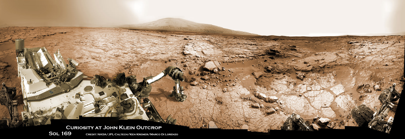
Curiosity accomplished Historic 1st drilling into Martian rock at John Klein outcrop on Feb 8, 2013 (Sol 182) and discovered a habitable zone, shown in this context mosaic view of the Yellowknife Bay basin taken on Jan. 26 (Sol 169). The robotic arm is pressing down on the surface at John Klein outcrop of veined hydrated minerals – dramatically back dropped with her ultimate destination; Mount Sharp. Credit: NASA/JPL-Caltech/Ken Kremer-kenkremer.com/Marco Di Lorenzo
This limited availability, timed experience is available on a first-come, first-served basis. Reservations must be made the day of your visite at the Destination: Mars reservation counter, says the KSC Visitor Complex (KSCVC).
You can get more information or book a visit to Kennedy Space Center Visitor Complex, by clicking on the website link:
Be sure to visit this spectacular holographic exhibit before it closes on New Year’s Day 2017 because it is only showing at KSCVC.
There are no plans to book it at other venues, Norris told me.
Apollo 11 moonwalker Buzz Aldrin describes newly opened ‘Destination Mars’ holographic experience during media preview at the Kennedy Space Center visitor complex in Florida on Sept. 18, 2016. Credit: Ken Kremer/kenkremer.com
As of today, Sol 1465, September 19, 2016, Curiosity has driven over 7.9 miles (12.7 kilometers) since its August 2012 landing inside Gale Crater, and taken over 354,000 amazing images.
Apollo 11 moonwalker Buzz Aldrin during media preview of newly opened ‘Destination Mars’ holographic experience at the Kennedy Space Center visitor complex in Florida on Sept. 18, 2016. Credit Julian Leek
Stay tuned here for Ken’s continuing Earth and planetary science and human spaceflight news.
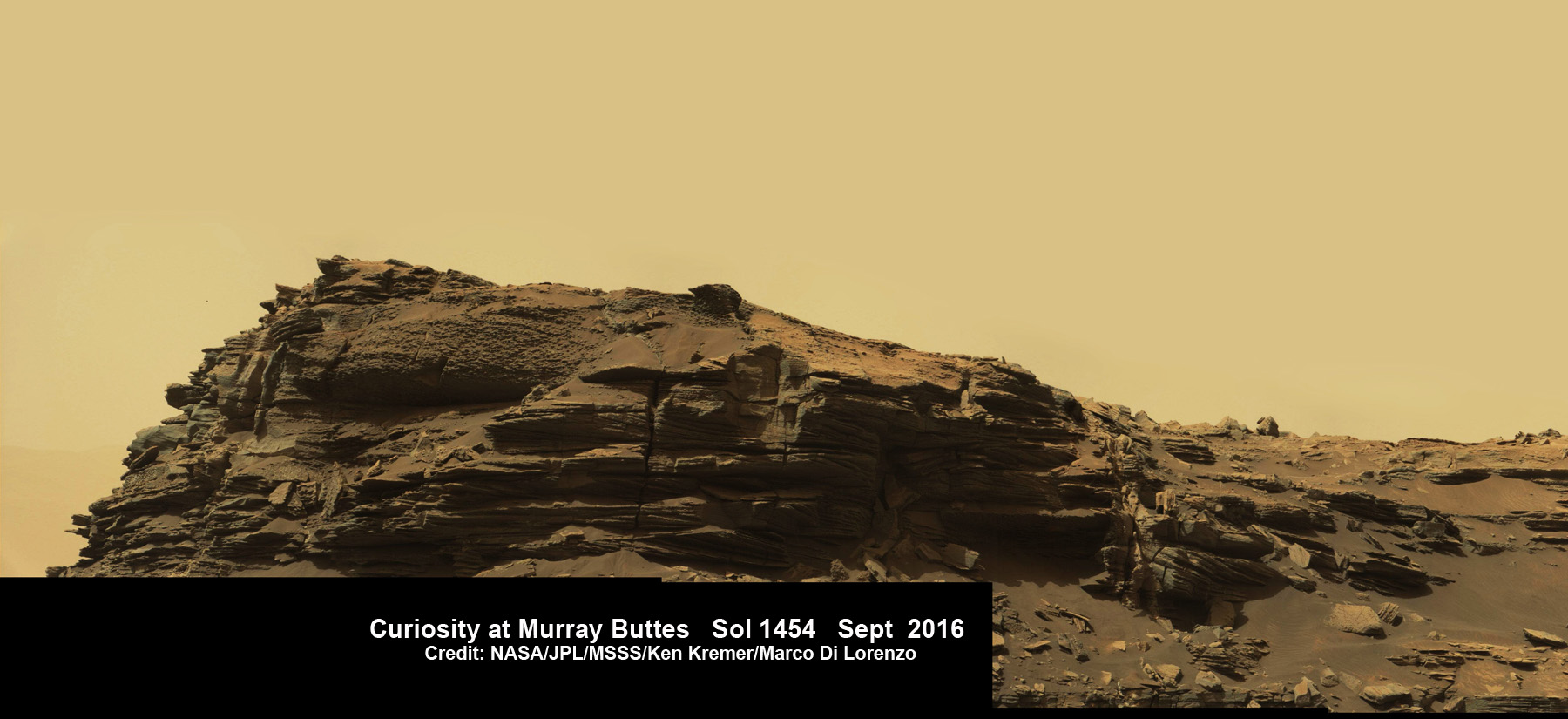
Dramatic hillside view showing sloping buttes and layered outcrops within of the Murray Buttes region on lower Mount Sharp from the Mast Camera (Mastcam) on NASA's Curiosity Mars rover. This photo mosaic is stitched and cropped from Mastcam camera raw images taken on Sol 1454, Sept. 8, 2016, with added artificial sky. Credit: NASA/JPL/MSSS/Ken Kremer/kenkremer.com/Marco Di Lorenzo
Spectacular wide angle mosaic view showing sloping buttes and layered outcrops within the Murray Buttes region on lower Mount Sharp from the Mast Camera (Mastcam) on NASA’s Curiosity Mars rover. This photo mosaic is stitched from Mastcam camera raw images taken on Sol 1454, Sept. 8, 2016 with added artificial sky. Credit: NASA/JPL/MSSS/Ken Kremer/kenkremer.com/Marco Di Lorenzo
The most stunning panoramic vistas likely ever snapped by NASA’s Curiosity rover reveal spectacularly layered Martian rock formations in such exquisite detail that they look and feel just like America’s desert Southwest landscapes. They were just captured a week ago and look like a scene straight out of the hugely popular science fiction movie ‘The Martian’ – only they are real !!
Indeed several magnificent panoramas were taken by Curiosity in just the past week and you can see our newly stitched mosaic versions of several – above and below.
The rock formations lie in the “Murray Buttes” region of lower Mount Sharp where Curiosity has been exploring for roughly the past month. She just finished a campaign of detailed science observations and is set to bore a new sampling hole into the Red Planet, as you read this.
While scouting around the “Murray Buttes,” the SUV sized rover captured thousands of color and black and white raw images to document the geology of this thus far most unrivaled spot on the Red Planet ever visited by an emissary from Earth.
So the image processing team of Ken Kremer and Marco Di Lorenzo has begun stitching together wide angle mosaic views starting with images gathered by the high resolution mast mounted Mastcam right color camera, or M-100, on Sept, 8, 2016, or Sol 1454 of the robots operations on Mars.
Dramatic closeup mosaic view of Martian butte with sandstone layers showing cross-bedding in the Murray Buttes region on lower Mount Sharp from the Mast Camera (Mastcam) on NASA’s Curiosity Mars rover. This photo mosaic is stitched from Mastcam camera raw images taken on Sol 1454, Sept. 8, 2016, with added artificial sky. Credit: NASA/JPL/MSSS/Ken Kremer/kenkremer.com/Marco Di Lorenzo
The mosaics give context and show us exactly what the incredible alien surroundings look like where the six wheeled rover is exploring today.
The imagery of the Murray Buttes and mesas show them to be eroded remnants of ancient sandstone that originated when winds deposited sand after lower Mount Sharp had formed.
Wide angle mosaic shows lower region of Mount Sharp at center in between spectacular sloping hillsides and layered rock outcrops of the Murray Buttes region in Gale Crater as imaged by the Mast Camera (Mastcam) on NASA’s Curiosity Mars rover. This photo mosaic is stitched from Mastcam camera raw images taken on Sol 1451, Sept. 5, 2016 with added artificial sky. Credit: NASA/JPL/MSSS/Ken Kremer/kenkremer.com/Marco Di Lorenzo
Scanning around the Murray Buttes mosaics one sees finely layered rocks, sloping hillsides, the distant rim of Gale Crater barely visible through the dusty haze, dramatic hillside outcrops with sandstone layers exhibiting cross-bedding. The presence of “cross-bedding” indicates that the sandstone was deposited by wind as migrating sand dunes, says the team.
Wide angle mosaic view shows spectacular buttes and layered sandstone in the Murray Buttes region on lower Mount Sharp from the Mastcam cameras on NASA’s Curiosity Mars rover. This photo mosaic was assembled from Mastcam color camera raw images taken on Sol 1455, Sept. 9, 2016 and stitched by Marco Di Lorenzo and Ken Kremer, with added artificial sky. Credit: NASA/JPL/MSSS/Ken Kremer/kenkremer.com/Marco Di Lorenzo
But there is no time to rest as she was commanded to head further south to the last of these Murray Buttes. And right now the team is implementing a plan for Curiosity to drill a new hole in Mars today – at a target named “Quela” at the base of the last of the buttes. The rover approached the butte from the south side a few days ago to get in place and plan for the drilling, take imagery to document stratigraphy and make compositional observations with the ChemCam laser instrument.
“It’s always an exciting day on Mars when you prepare to drill another sample – an engineering feat that we’ve become so accustomed to that I sometimes forget how impressive this really is!” wrote Lauren Edgar, in a mission update today. Edgar is a Research Geologist at the USGS Astrogeology Science Center and a member of the MSL science team.
Curiosity will then continue further south to begin exploring higher and higher sedimentary layers up Mount Sharp. The “Murray Buttes” are the entry way along Curiosity’s planned route up lower Mount Sharp.
Dramatic closeup view of hillside outcrop with sandstone layers showing cross-bedding in the Murray Buttes region on lower Mount Sharp from the Mast Camera (Mastcam) on NASA’s Curiosity Mars rover. This photo mosaic is stitched and cropped from Mastcam camera raw images taken on Sol 1454, Sept. 8, 2016, with added artificial sky. Credit: NASA/JPL/MSSS/Ken Kremer/kenkremer.com/Marco Di Lorenzo
Meanwhile Curiosity is still conducting science observations of the last drill sample gathered from the “Marimba” target in August focusing on MAHLI and APXS examination of the dump pile leftovers from the sieved sample. She just completed chemical analysis of the sieved sample using the miniaturized SAM and CheMin internal chemistry laboratories.
It’s interesting to note that although the buttes are striking, their height also presents communications issues by blocking radio signals with NASA’s orbiting relay satellites. NASA’s Opportunity rover faced the same issues earlier this year while exploring inside the high walled Marathon Valley along Ecdeavour Crater.
“While the buttes are beautiful, they pose a challenge to communications, because they are partially occluding communications between the rover and the satellites we use to relay data (MRO and ODY), so sometimes the data volume that we can relay is pretty low” wrote Edgar.
“But it’s a small price to pay for the great stratigraphic exposures and gorgeous view!”
Dramatic hillside view showing sloping buttes and layered outcrops within of the Murray Buttes region on lower Mount Sharp from the Mast Camera (Mastcam) on NASA’s Curiosity Mars rover. This photo mosaic is stitched and cropped from Mastcam camera raw images taken on Sol 1454, Sept. 8, 2016, with added artificial sky. Credit: NASA/JPL/MSSS/Ken Kremer/kenkremer.com/Marco Di Lorenzo
Ascending and diligently exploring the sedimentary lower layers of Mount Sharp, which towers 3.4 miles (5.5 kilometers) into the Martian sky, is the primary destination and goal of the rovers long term scientific expedition on the Red Planet.
Three years ago, the team informally named the Murray Buttes site to honor Caltech planetary scientist Bruce Murray (1931-2013), a former director of NASA’s Jet Propulsion Laboratory, Pasadena, California. JPL manages the Curiosity mission for NASA.
As of today, Sol 1461, September 15, 2016, Curiosity has driven over 7.9 miles (12.7 kilometers) since its August 2012 landing inside Gale Crater, and taken over 353,000 amazing images.
Stay tuned here for Ken’s continuing Earth and planetary science and human spaceflight news.
Curiosity rover panorama of Mount Sharp captured on June 6, 2014 (Sol 651) during traverse inside Gale Crater. Note rover wheel tracks at left. She will eventually ascend the mountain at the ‘Murray Buttes’ at right later this year. Assembled from Mastcam color camera raw images and stitched by Marco Di Lorenzo and Ken Kremer. Credit: NASA/JPL/MSSS/Marco Di Lorenzo/Ken Kremer-kenkremer.com
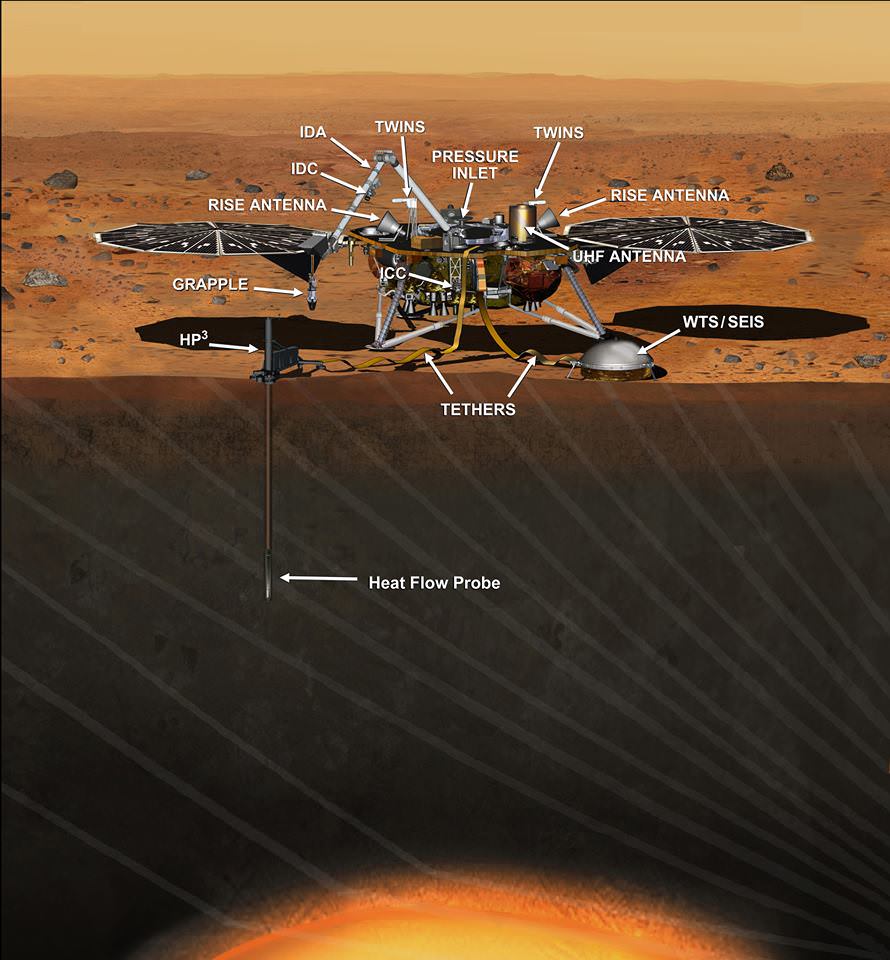
This artist's concept depicts the InSight lander on Mars after the lander's robotic arm has deployed a seismometer and a heat probe directly onto the ground. InSight is the first mission dedicated to investigating the deep interior of Mars. The findings will advance understanding of how all rocky planets, including Earth, formed and evolved. NASA approved a new launch date in May 2018. Credits: NASA/JPL-Caltech
This artist’s concept depicts the InSight lander on Mars after the lander’s robotic arm has deployed a seismometer and a heat probe directly onto the ground. InSight is the first mission dedicated to investigating the deep interior of Mars. The findings will advance understanding of how all rocky planets, including Earth, formed and evolved. NASA approved a new launch date in May 2018. Credits: NASA/JPL-Caltech
Top NASA managers have formally approved the launch of the agency’s InSight Lander to the Red Planet in the spring of 2018 following a postponement from this spring due to the discovery of a vacuum leak in a prime science instrument supplied by France.
The InSight missions goal is to accomplish an unprecedented study of the deep interior of the most Earth-like planet in our solar system.
NASA is now targeting a new launch window that begins May 5, 2018, for the Interior Exploration using Seismic Investigations, Geodesy and Heat Transport (InSight). mission aimed at studying the deep interior of Mars. The Mars landing is now scheduled for Nov. 26, 2018.
InSight had originally been slated for blastoff on March 4, 2016 atop a United Launch Alliance (ULA) Atlas V rocket from Vandenberg Air Force Base, California.
But the finding of a vacuum leak in its prime science instrument, the French-built Seismic Experiment for Interior Structure (SEIS), in December 2015 forced an unavoidable two year launch postponement. Because of the immutable laws of orbital mechanics, launch opportunities to the Red Planet only occur approximately every 26 months.
InSight’s purpose is to help us understand how rocky planets – including Earth – formed and evolved. The science goal is totally unique – to “listen to the heart of Mars to find the beat of rocky planet formation.”
The revised launch date was approved by the agency’s Science Mission Directorate.
“Our robotic scientific explorers such as InSight are paving the way toward an ambitious journey to send humans to the Red Planet,” said Geoff Yoder, acting associate administrator for NASA’s Science Mission Directorate, in Washington, in a statement.
“It’s gratifying that we are moving forward with this important mission to help us better understand the origins of Mars and all the rocky planets, including Earth.”
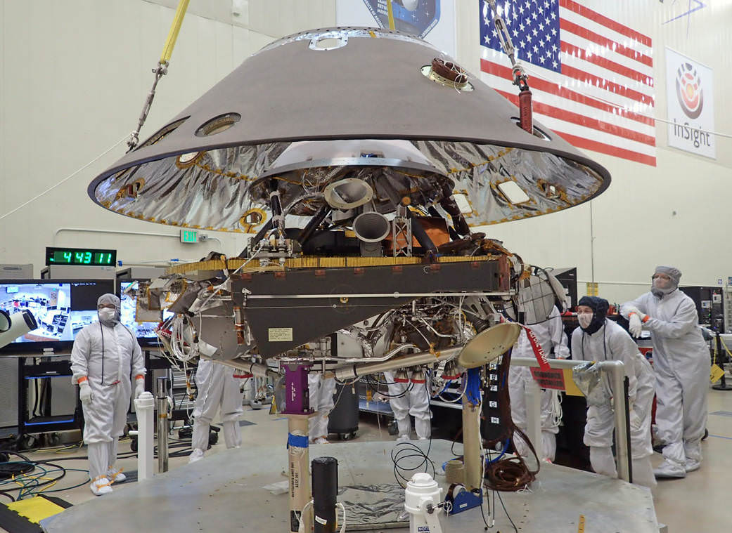
NASA’s InSight Mars lander spacecraft in a Lockheed Martin clean room near Denver. As part of a series of deployment tests, the spacecraft was commanded to deploy its solar arrays in the clean room to test and verify the exact process that it will use on the surface of Mars.
Since InSight would not have been able to carry out and fulfill its intended research objectives because of the vacuum leak in its defective SEIS seismometer instrument, NASA managers had no choice but to scrub this year’s launch. For a time its outlook for a future revival seemed potentially uncertain in light of today’s constrained budget environment.
The leak, if left uncorrected, would have rendered the flawed probe useless to carry out the unprecedented scientific research foreseen to measure the planets seismic activity and sense for “Marsquakes” to determine the nature of the Red Planet’s deep interior.
“The SEIS instrument — designed to measure ground movements as small as half the radius of a hydrogen atom — requires a perfect vacuum seal around its three main sensors in order to withstand harsh conditions on the Red Planet,” according to NASA.
The SEIS seismometer instrument was provided by the Centre National d’Études Spatiales (CNES) – the French national space agency equivalent to NASA. SEIS is one of the two primary science instruments aboard InSight. The other instrument measuring heat flow from the Martian interior is provided by the German Aerospace Center (DLR) and is named Heat Flow and Physical Properties Package (HP3). The HP3 instrument checked out perfectly.
NASA Jet Propulsion Laboratory (JPL) was assigned lead responsibility for the “replanned” mission and insuring that the SEIS instrument operates properly with no leaks.
JPL is “redesigning, developing and qualifying the instrument’s evacuated container and the electrical feedthroughs that failed previously. France’s space agency, the Centre National d’Études Spatiales (CNES), will focus on developing and delivering the key sensors for SEIS, integration of the sensors into the container, and the final integration of the instrument onto the spacecraft.”
“We’ve concluded that a replanned InSight mission for launch in 2018 is the best approach to fulfill these long-sought, high-priority science objectives,” said Jim Green, director of NASA’s Planetary Science Division.
The cost of the two-year delay and instrument redesign amounts to $153.8 million, on top of the original budget for InSight of $675 million.
NASA says this cost will not force a delay or cancellation to any current missions. However, “there may be fewer opportunities for new missions in future years, from fiscal years 2017-2020.”
Back shell of NASA’s InSight spacecraft is being lowered onto the mission’s lander, which is folded into its stowed configuration. The back shell and a heat shield form the aeroshell, which will protect the lander as the spacecraft plunges into the upper atmosphere of Mars. Launch now rescheduled to May 2018 to fix French-built seismometer. Credit: NASA/JPL-Caltech/Lockheed Martin
Lockheed Martin is the prime contractor for InSight and placed the spacecraft in storage while SEIS is fixed.
InSight is funded by NASA’s Discovery Program of low cost, focused science missions along with the science instrument funding contributions from France and Germany.
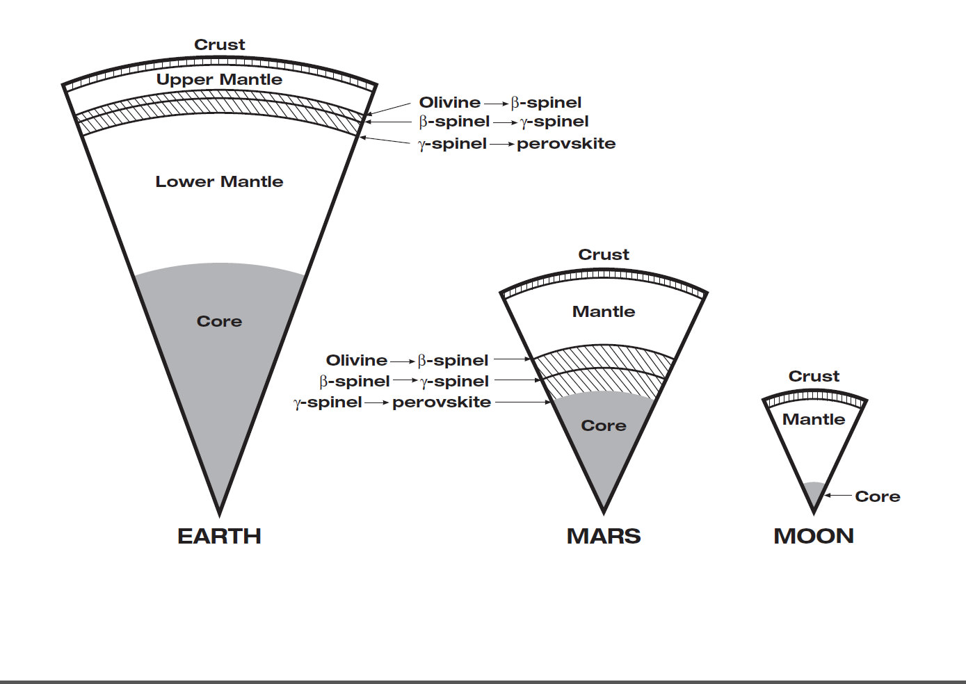
Mars has the same basic internal structure as the Earth and other terrestrial (rocky) planets. It is large enough to have pressures equivalent to those throughout the Earth’s upper mantle, and it has a core with a similar fraction of it’s mass. In contrast, the pressure even near the center of the Moon barely reach that just below the Earth’s crust and it has a tiny, almost negligible core. The size of Mars indicates that it must have undergone many of the same separation and crystallization processes that formed the Earth’s crust and core during early planetary formation. Credit: JPL/NASA
Learn more about OSIRIS-REx, InSight Mars lander, SpaceX missions, Juno at Jupiter, SpaceX CRS-9 rocket launch, ISS, ULA Atlas and Delta rockets, Orbital ATK Cygnus, Boeing, Space Taxis, Mars rovers, Orion, SLS, Antares, NASA missions and more at Ken’s upcoming outreach events:
Sep 6-8: “OSIRIS-REx lainch, SpaceX missions/launches to ISS on CRS-9, Juno at Jupiter, ULA Delta 4 Heavy spy satellite, SLS, Orion, Commercial crew, Curiosity explores Mars, Pluto and more,” Kennedy Space Center Quality Inn, Titusville, FL, evenings
This 360-degree panorama was acquired by the Mast Camera (Mastcam) on NASA's Curiosity Mars rover as the rover neared features called "Murray Buttes" on lower Mount Sharp. Credit: NASA/JPL-Caltech/MSSS
This 360-degree panorama was acquired by the Mast Camera (Mastcam) on NASA’s Curiosity Mars rover as the rover neared features called “Murray Buttes” on lower Mount Sharp. Credit: NASA/JPL-Caltech/MSSS
This is a key milestone for the Curiosity mission because the “Murray Buttes” are the entry way along Curiosity’s planned route up lower Mount Sharp.
Ascending and diligently exploring the sedimentary lower layers of Mount Sharp, which towers 3.4 miles (5.5 kilometers) into the Martian sky, is the primary destination and goal of the rovers long term scientific expedition on the Red Planet.
The area features eroded mesas and buttes that are reminiscent of the U.S. Southwest.
So the team directed the rover to capture a 360-degree color panorama using the robots mast mounted Mastcam camera earlier this month on Aug. 5.
The full panorama shown above combines more than 130 images taken by Curiosity on Aug. 5, 2016, during the afternoon of Sol 1421 by the Mastcam’s left-eye camera.
In particular note the dark, flat-topped mesa seen to the left of the rover’s arm. It stands about 50 feet (about 15 meters) high and, near the top, about 200 feet (about 60 meters) wide.
Coincidentally, Aug. 5 also marks the fourth anniversary of the six wheeled rovers landing on the Red Planet via the unprecedented Sky Crane maneuver.
You can explore this spectacular Mars panorama in great detail via this specially produced 360-degree panorama from JPL. Simply move the magnificent view back and forth and up and down and all around with your mouse or mobile device.
Video Caption: This 360-degree panorama was acquired on Aug. 5, 2016, by the Mastcam on NASA’s Curiosity Mars rover as the rover neared features called “Murray Buttes” on lower Mount Sharp. The dark, flat-topped mesa seen to the left of the rover’s arm is about 50 feet (about 15 meters) high and, near the top, about 200 feet (about 60 meters) wide.
“The buttes and mesas are capped with rock that is relatively resistant to wind erosion. This helps preserve these monumental remnants of a layer that formerly more fully covered the underlying layer that the rover is now driving on,” say rover scientists.
“The relatively flat foreground is part of a geological layer called the Murray formation, which formed from lakebed mud deposits. The buttes and mesas rising above this surface are eroded remnants of ancient sandstone that originated when winds deposited sand after lower Mount Sharp had formed. Curiosity closely examined that layer — the Stimson formation — during the first half of 2016 while crossing a feature called “Naukluft Plateau” between two exposures of the Murray formation.”
Three years ago, the team informally named the site to honor Caltech planetary scientist Bruce Murray (1931-2013), a former director of NASA’s Jet Propulsion Laboratory, Pasadena, California. JPL manages the Curiosity mission for NASA.
As of today, Sol 1447, August 31, 2016, Curiosity has driven over 7.9 miles (12.7 kilometers) since its August 2012 landing, and taken over 348,500 amazing images.
Curiosity explores Red Planet paradise at Namib Dune during Christmas 2015 – backdropped by Mount Sharp. Curiosity took first ever self-portrait with Mastcam color camera after arriving at the lee face of Namib Dune. This photo mosaic shows a portion of the full self portrait and is stitched from Mastcam color camera raw images taken on Sol 1197, Dec. 19, 2015. Credit: NASA/JPL/MSSS/Ken Kremer/kenkremer.com/Marco Di Lorenzo
Stay tuned here for Ken’s continuing Earth and planetary science and human spaceflight news.
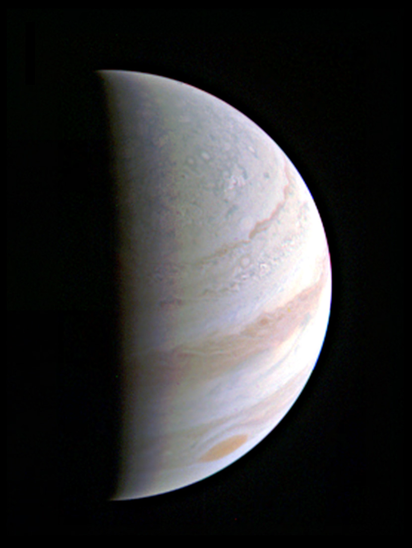
Jupiter's north polar region is coming into view as NASA's Juno spacecraft approaches the giant planet. This view of Jupiter was taken on August 27, when Juno was 437,000 miles (703,000 kilometers) away. Credits: NASA/JPL-Caltech/SwRI/MSSS
Jupiter’s north polar region is coming into view as NASA’s Juno spacecraft approaches the giant planet. This view of Jupiter was taken on August 27, when Juno was 437,000 miles (703,000 kilometers) away. Credits: NASA/JPL-Caltech/SwRI/MSSS
Saturdays’ close encounter with Jupiter soaring over its north pole was the first of 36 planned orbital flyby’s by Juno during the scheduled 20 month long prime mission.
“Soarin’ over #Jupiter. My 1st up-close look of the gas-giant world was a success!” the probe tweeted today post-flyby.
NASA released Juno’s first up-close image taken by the JunoCam visible light camera just hours later – as seen above.
Juno was speeding at some 130,000 mph (208,000 kilometers per hour) during the time of Saturday’s closest approach at 9:44 a.m. EDT (6:44 a.m. PDT 13:44 UTC) over the north polar region.
It passed merely 2,600 miles (4,200 kilometers) above the turbulent clouds of the biggest planet in our solar system during its initial 53.5 day polar elliptical capture orbit.
And apparently everything proceeded as the science and engineering team leading the mission to the gas giant had planned.
“Early post-flyby telemetry indicates that everything worked as planned and Juno is firing on all cylinders,” said Rick Nybakken, Juno project manager at NASA’s Jet Propulsion Laboratory in Pasadena, California, in a statement.
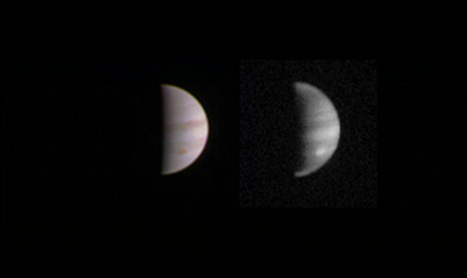
This dual view of Jupiter was taken on August 23, when NASA’s Juno spacecraft was 2.8 million miles (4.4 million kilometers) from the gas giant planet on the inbound leg of its initial 53.5-day capture orbit. Credit: NASA/JPL-Caltech/SwRI/MSSS
Indeed Saturday’s encounter will count as the closest of the entire prime mission. It also marks the first time that the entire suite of nine state-of-the-art science instruments had been turned on to gather the totally unique observations of Jupiter’s interior and exterior environment.
“We are getting some intriguing early data returns as we speak,” said Scott Bolton, principal investigator of Juno from the Southwest Research Institute in San Antonio, in a statement.
“This is our first opportunity to really take a close-up look at the king of our solar system and begin to figure out how he works.”
Additional up-close high resolution imagery of the Jovian atmosphere, swirling cloud tops and north and south poles snapped by JunoCam will be released in the coming weeks, perhaps as soon as next week.
“We are in an orbit nobody has ever been in before, and these images give us a whole new perspective on this gas-giant world,” said Bolton.
“It will take days for all the science data collected during the flyby to be downlinked and even more to begin to comprehend what Juno and Jupiter are trying to tell us.”
The prime mission is scheduled to end in February of 2018 with a suicide plunge into the Jovian atmosphere to prevent any possible contamination with Jupiter’s potentially habitable moons such as Europa and Ganymede.
“No other spacecraft has ever orbited Jupiter this closely, or over the poles in this fashion,” said Steve Levin, Juno project scientist from NASA’s Jet Propulsion Laboratory in Pasadena, California. “This is our first opportunity and there are bound to be surprises. We need to take our time to make sure our conclusions are correct.”
The team did release an approach image taken by JunoCam on Aug. 23 when the spacecraft was 2.8 million miles (4.4 million kilometers) from the gas giant planet on the inbound leg of its initial 53.5-day capture orbit.
One additional long period orbit is planned. The main engine will fire again in October to reduce the orbit to the 14 day science orbit.
Animation of Juno 14-day orbits starting in late 2016. Credits: NASA/JPL-Caltech
The solar powered probe will collect unparalleled new data that will unveil the hidden inner secrets of Jupiter’s origin and evolution as it peers “beneath the obscuring cloud cover of Jupiter and study its auroras to learn more about the planet’s origins, structure, atmosphere and magnetosphere.”
The Juno spacecraft was built by prime contractor Lockheed Martin in Denver.
Illustration of NASA’s Juno spacecraft firing its main engine to slow down and go into orbit around Jupiter. Lockheed Martin built the Juno spacecraft for NASA’s Jet Propulsion Laboratory. Credit: NASA/Lockheed Martin
The last NASA spacecraft to orbit Jupiter was Galileo in 1995. It explored the Jovian system until 2003.
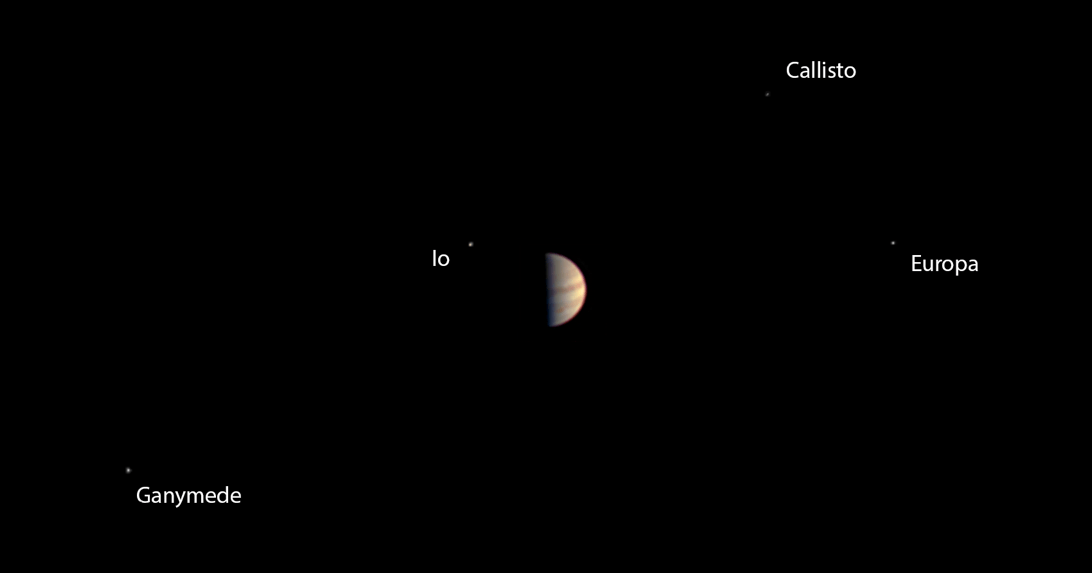
In the final weeks of the approach before Jupiter Orbit Insertion (JOI), JunoCam captured dramatic views of Jupiter and all four of the Galilean Moons moons — Io, Europa, Ganymede and Callisto.
At the post JOI briefing at JPL on July 5, these were combined into a spectacular JunoCam time-lapse movie released by Bolton and NASA.
Watch and be mesmerized -“for humanity, our first real glimpse of celestial harmonic motion” says Bolton.
Video caption: NASA’s Juno spacecraft captured a unique time-lapse movie of the Galilean satellites in motion about Jupiter. The movie begins on June 12th with Juno 10 million miles from Jupiter, and ends on June 29th, 3 million miles distant. The innermost moon is volcanic Io; next in line is the ice-crusted ocean world Europa, followed by massive Ganymede, and finally, heavily cratered Callisto. Galileo observed these moons to change position with respect to Jupiter over the course of a few nights. From this observation he realized that the moons were orbiting mighty Jupiter, a truth that forever changed humanity’s understanding of our place in the cosmos. Earth was not the center of the Universe. For the first time in history, we look upon these moons as they orbit Jupiter and share in Galileo’s revelation. This is the motion of nature’s harmony. Credits: NASA/JPL-Caltech/MSSS
Stay tuned here for Ken’s continuing Earth and Planetary science and human spaceflight news.
United Launch Alliance Atlas V liftoff with NASA’s Juno to Jupiter orbiter on Aug. 5, 2011 from Cape Canaveral Air Force Station, Florida. Credit: Ken Kremer/kenkremer.com
This color view from NASA's Juno spacecraft is made from some of the first images taken by JunoCam after the spacecraft entered orbit around Jupiter on July 4, 2016. Credits: NASA/JPL-Caltech/SwRI/MSSS
This color view from NASA’s Juno spacecraft is made from some of the first images taken by JunoCam after the spacecraft entered orbit around Jupiter on July 4, 2016. Credits: NASA/JPL-Caltech/SwRI/MSSS
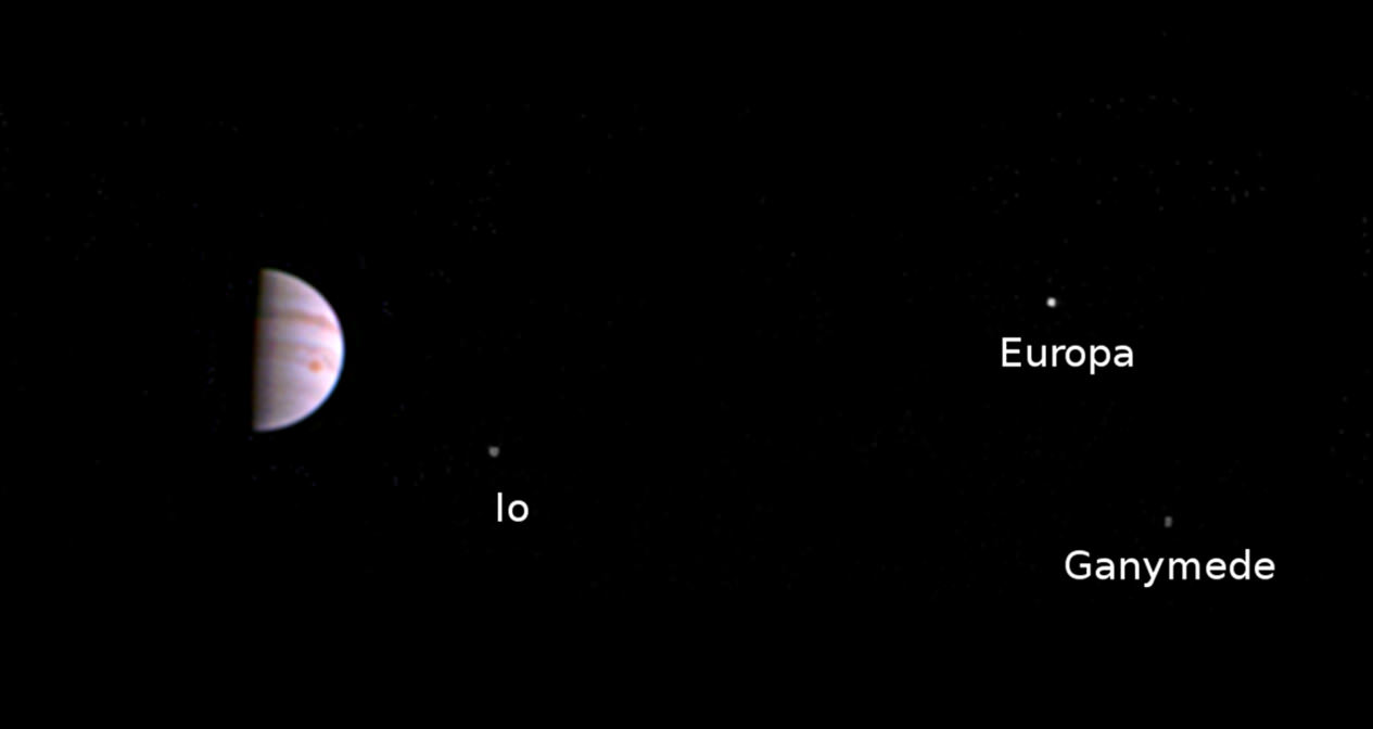
NASA’s newly arrived Jovian orbiter Juno has transmitted its first imagery since reaching orbit last week on July 4 after swooping over Jupiter’s cloud tops and powering back up its package of state-of-the-art science instruments for unprecedented research into determining the origin of our solar systems biggest planet.
The ‘Galilean’ moons are annotated from left to right in the lead image.
Juno’s visible-light camera named JunoCam was turned on six days after Juno fired its main engine to slow down and be captured into orbit around Jupiter – the ‘King of the Planets’ following a nearly five year long interplanetary voyage from Earth.
The image was taken when Juno was 2.7 million miles (4.3 million kilometers) distant from Jupiter on July 10, at 10:30 a.m. PDT (1:30 p.m. EDT, 5:30 UTC), and traveling on the outbound leg of its initial 53.5-day capture orbit.
Juno came within only about 3000 miles of the cloud tops and passed through Jupiter’s extremely intense and hazardous radiation belts during orbital arrival over the north pole.
Illustration of NASA’s Juno spacecraft firing its main engine to slow down and go into orbit around Jupiter. Lockheed Martin built the Juno spacecraft for NASA’s Jet Propulsion Laboratory. Credit: NASA/Lockheed Martin
The newly released JunoCam image is visible proof that Juno survived the do-or-die orbital fireworks on America’s Independence Day that placed the baskeball-court sized probe into orbit around Jupiter – and is in excellent health to carry out its groundbreaking mission to elucidate Jupiter’s ‘Genesis.’
“This scene from JunoCam indicates it survived its first pass through Jupiter’s extreme radiation environment without any degradation and is ready to take on Jupiter,” said Scott Bolton, principal investigator from the Southwest Research Institute in San Antonio, in a statement.
“We can’t wait to see the first view of Jupiter’s poles.”
Within two days of the nerve wracking and fully automated 35-minute-long Jupiter Orbital Insertion (JOI) maneuver, the Juno engineering team begun powering up five of the probes science instruments on July 6.
Animation of Juno 14-day orbits starting in late 2016. Credits: NASA/JPL-Caltech
All nonessential instruments and systems had been powered down in the final days of Juno’s approach to Jupiter to ensure the maximum chances for success of the critical JOI engine firing.
“We had to turn all our beautiful instruments off to help ensure a successful Jupiter orbit insertion on July 4,” said Bolton.
“But next time around we will have our eyes and ears open. You can expect us to release some information about our findings around September 1.”
Juno resumed high data rate communications with Earth on July 5, the day after achieving orbit.
We can expect to see more JunoCam images taken during this first orbital path around the massive planet.
But the first high resolution images are still weeks away and will not be available until late August on the inbound leg when the spacecraft returns and swoops barely above the clouds.
“JunoCam will continue to take images as we go around in this first orbit,” said Candy Hansen, Juno co-investigator from the Planetary Science Institute, Tucson, Arizona, in a statement.
“The first high-resolution images of the planet will be taken on August 27 when Juno makes its next close pass to Jupiter.”
All of JunoCams images will be released to the public.
During a 20 month long science mission – entailing 37 orbits lasting 14 days each – the probe will plunge to within about 2,600 miles (4,100 kilometers) of the turbulent cloud tops.
It will collect unparalleled new data that will unveil the hidden inner secrets of Jupiter’s origin and evolution as it peers “beneath the obscuring cloud cover of Jupiter and study its auroras to learn more about the planet’s origins, structure, atmosphere and magnetosphere.”
The solar powered Juno spacecraft approached Jupiter over its north pole, affording an unprecedented perspective on the Jovian system – “which looks like a mini solar system” – as it flew through the giant planets intense radiation belts in ‘autopilot’ mode.
Juno is the first solar powered probe to explore Jupiter or any outer planet.
In the final weeks of the approach JunoCam captured dramatic views of Jupiter and all four of the Galilean Moons moons — Io, Europa, Ganymede and Callisto.
At the post JOI briefing on July 5, these were combined into a spectacular JunoCam time-lapse movie released by Bolton and NASA.
Watch and be mesmerized -“for humanity, our first real glimpse of celestial harmonic motion” says Bolton.
Video caption: NASA’s Juno spacecraft captured a unique time-lapse movie of the Galilean satellites in motion about Jupiter. The movie begins on June 12th with Juno 10 million miles from Jupiter, and ends on June 29th, 3 million miles distant. The innermost moon is volcanic Io; next in line is the ice-crusted ocean world Europa, followed by massive Ganymede, and finally, heavily cratered Callisto. Galileo observed these moons to change position with respect to Jupiter over the course of a few nights. From this observation he realized that the moons were orbiting mighty Jupiter, a truth that forever changed humanity’s understanding of our place in the cosmos. Earth was not the center of the Universe. For the first time in history, we look upon these moons as they orbit Jupiter and share in Galileo’s revelation. This is the motion of nature’s harmony. Credits: NASA/JPL-Caltech/MSSS
The $1.1 Billion Juno was launched on Aug. 5, 2011 from Cape Canaveral, Florida atop the most powerful version of the Atlas V rocket augmented by 5 solid rocket boosters and built by United Launch Alliance (ULA). That same Atlas V 551 version just launched MUOS-5 for the US Navy on June 24.
The Juno spacecraft was built by prime contractor Lockheed Martin in Denver.
The mission will end in February 2018 with an intentional death dive into the atmosphere to prevent any possibility of a collision with Europa, one of Jupiter’s moons that is a potential abode for life.
The last NASA spacecraft to orbit Jupiter was Galileo in 1995. It explored the Jovian system until 2003.
From Earth’s perspective, Jupiter was in conjunction with Earth’s Moon shortly after JOI during the first week in July.
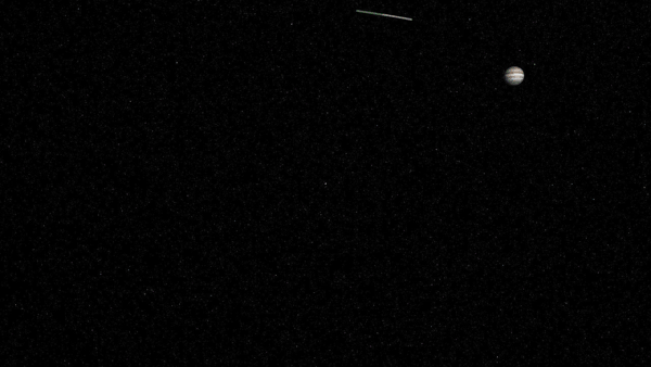
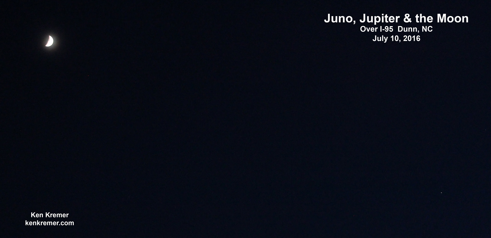
Personally its thrilling to realize that an emissary from Earth is once again orbiting Jupiter after a 13 year long hiatus as seen in the authors image below – coincidentally taken the same day as JunoCam’s first image from orbit.
Juno, Jupiter and the Moon as seen from I-95 over Dunn, NC on July 10, 2016. Credit: Ken Kremer/kenkremer.com
Stay tuned here for Ken’s continuing Earth and Planetary science and human spaceflight news.
Learn more about Juno at Jupiter, SpaceX CRS-9 rocket launch, ISS, ULA Atlas and Delta rockets, Orbital ATK Cygnus, Boeing, Space Taxis, Mars rovers, Orion, SLS, Antares, NASA missions and more at Ken’s upcoming outreach events:
July 15-18: “SpaceX launches to ISS on CRS-9, Juno at Jupiter, ULA Delta 4 Heavy spy satellite, SLS, Orion, Commercial crew, Curiosity explores Mars, Pluto and more,” Kennedy Space Center Quality Inn, Titusville, FL, evenings
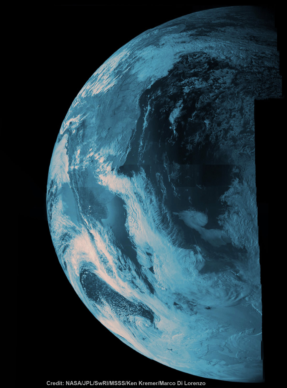
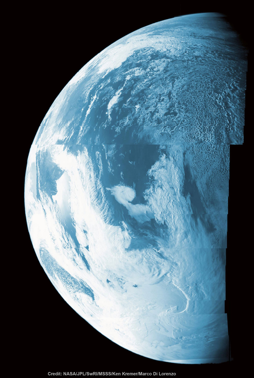
NASA’s Juno probe captured the image data for this composite picture during its Earth flyby on Oct. 9 over Argentina, South America and the southern Atlantic Ocean. Raw imagery was reconstructed and aligned by Ken Kremer and Marco Di Lorenzo, and false-color blue has been added to the view taken by a near-infrared filter that is typically used to detect methane. Credit: NASA/JPL/SwRI/MSSS/Ken Kremer/Marco Di Lorenzo
Illustration of NASA's Juno spacecraft firing its main engine to slow down and go into orbit around Jupiter. Lockheed Martin built the Juno spacecraft for NASA's Jet Propulsion Laboratory. Credit: NASA/Lockheed Martin
Illustration of NASA’s Juno spacecraft firing its main engine to slow down and go into orbit around Jupiter. Lockheed Martin built the Juno spacecraft for NASA’s Jet Propulsion Laboratory. Credit: NASA/Lockheed Martin
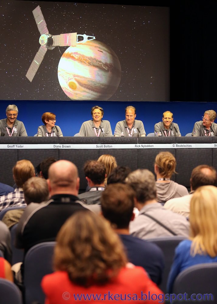
“NASA did it again!” pronounced an elated Scott Bolton, investigator of Juno from Southwest Research Institute in San Antonio, to loud cheers and applause from the overflow crowd of mission scientists and media gathered at the post orbit media briefing at NASA’s Jet Propulsion Laboratory (JPL) in Pasadena, Calif.
After a nearly five year journey covering 1.7-billion-miles (2.8-billion-kilometers) across our solar system, NASA’s basketball court-sized Juno orbiter achieved orbit around Jupiter, the ‘King of the Planets’ late Monday night, July 4, in a gift to all Americans on our 240th Independence Day and a gift to science to elucidate our origins.
“We are in orbit and now the fun begins, the science,” said Bolton at the briefing. “We just did the hardest thing NASA’s ever done! That’s my claim. I am so happy … and proud of this team.”
And the science is all about peering far beneath the well known banded cloud tops for the first time to investigate Jupiter’s deep interior with a suite of nine instruments, and discover the mysteries of its genesis and evolution and the implications for how we came to be.
“The deep interior of Jupiter is nearly unknown. That’s what we are trying to learn about. The origin of us.”
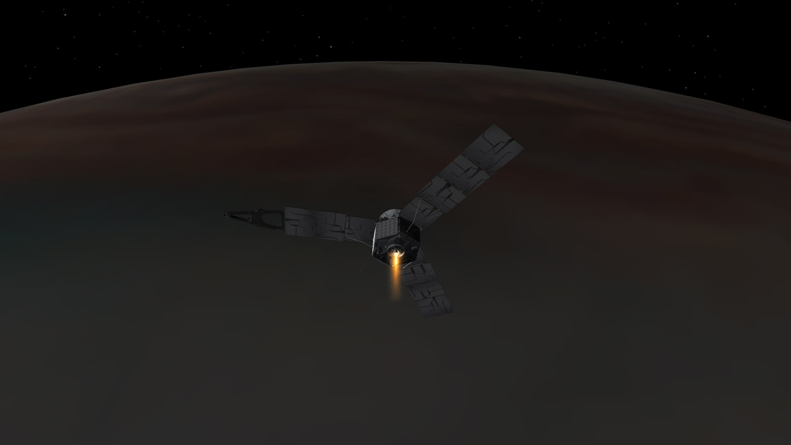
Solar powered Juno successfully entered a polar elliptical orbit around Jupiter after completing a must-do 35-minute-long firing of the main engine known as Jupiter Orbital Insertion or JOI.
The spacecraft approached Jupiter over its north pole, affording an unprecedented perspective on the Jovian system – “which looks like a mini solar system” – as it flew through the giant planets intense radiation belts in ‘autopilot’ mode.
“The mission team did great. The spacecraft did great. We are looking great. It’s a great day,” Bolton gushes.
Engineers tracking the telemetry received confirmation that the JOI burn was completed as planned at 8:53 p.m. PDT (11:53 p.m. EDT) Monday, July 4.
Juno is only the second probe from Earth to orbit Jupiter and the first solar powered probe to the outer planets. The gas giant is two and a half times more massive than all of the other planets combined.
“Independence Day always is something to celebrate, but today we can add to America’s birthday another reason to cheer — Juno is at Jupiter,” said NASA administrator Charlie Bolden in a statement.
“And what is more American than a NASA mission going boldly where no spacecraft has gone before? With Juno, we will investigate the unknowns of Jupiter’s massive radiation belts to delve deep into not only the planet’s interior, but into how Jupiter was born and how our entire solar system evolved.”
Artists concept NASA’s Juno spacecraft firing its main engine to slow down and go into orbit around Jupiter on July 4, 2016 nearly five years after launch. Credit: NASA
The do-or-die burn of Juno’s 645-Newton Leros-1b main engine started at 8:18 p.m. PDT (11:18 p.m. EDT), which had the effect of decreasing the spacecraft’s velocity by 1,212 miles per hour (542 meters per second) and allowing Juno to be captured in orbit around Jupiter. There were no second chances.
All of the science instruments were turned off on June 30 to keep the focus on the nail-biting insertion maneuver and preserve battery power, said Bolton.
“So tonight through tones Juno sang to us. And it was a song of perfection. After a 1.7 billion mile journey we hit tour burn targets within one second,” Rick Nybakken, Juno project manager from JPL, gleefully reported at the briefing.
“That’s how good our team is! And that’s how well our Juno spacecraft performed tonight.”
To accomplish the burn, the spacecraft first had to adjust it’s attitude to point the engine in the required direction to slow the spacecraft and then simultaneously also had the effect that the life giving solar panels were pointing away from the sun. It the only time during the entire mission at Jupiter that the solar panels were in darkness and not producing energy.
The spacecraft’s rotation rate was also spun up from 2 to 5 revolutions per minute (RPM) to help stabilize it during JOI. Juno is spin stabilized to maintain pointing.
After the burn was complete, Juno was spun down and adjusted to point to the sun before it ran out of battery power.
We have to get the blood flowing through Juno’s veins, Bolton emphasized.
It is equipped with 18,698 individual solar cells over 60 square meters of surface on the solar arrays to provide energy. Juno is spinning like a windmill through space with its 3 giant solar arrays. It is about 540 million miles (869 million kilometers) from Earth.
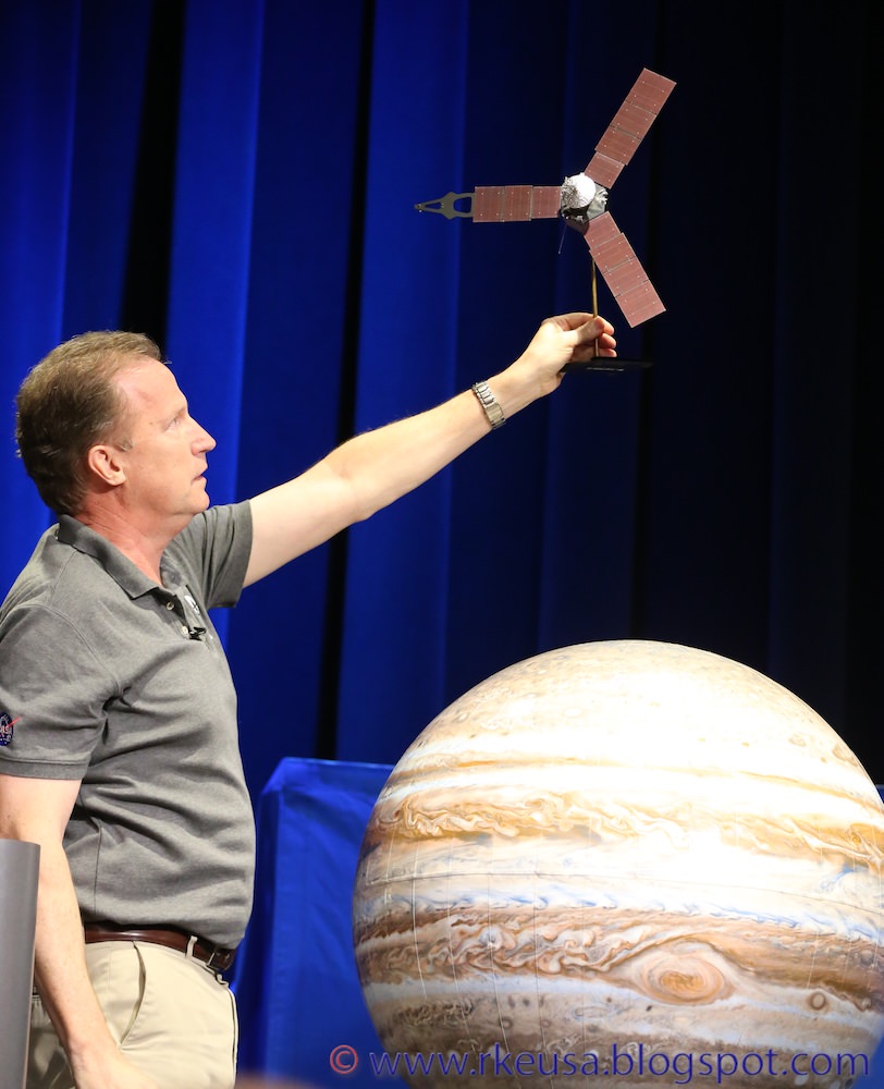
Juno mission briefing on July 5, 2016 at JPL after the successful JOI orbit insertion on July 4. Credit: Roland Keller/rkeusa.blogspot.com
Signals traveling at the speed of light take 48 minutes to reach Earth, said Nybakken.
So the main engine burn, which was fully automated, was already over for some 13 minutes before the first indications of the outcome reach Earth via a series of Doppler signals and tones.
“Tonight, 540 million miles away, Juno performed a precisely choreographed dance at blazing speeds with the largest, most intense planet in our solar system,” said Guy Beutelschies, director of Interplanetary Missions at Lockheed Martin Space Systems.
“Since launch, Juno has operated exceptionally well, and the flawless orbit insertion is a testament to everyone working on Juno and their focus on getting this amazing spacecraft to its destination. NASA now has a science laboratory orbiting Jupiter.”
“The spacecraft is now pointed back at the sun and the antenna back at Earth. The spacecraft performed well and did everything it needed to do,” he reported at the briefing.
“We are looking forward to getting all that science data to Scott and the team.”
“Juno is also the farthest mission to rely on solar power. And although they provide only 1/25th the power at Earth, they still provide over 500 watts of power at Jupiter,” said Nybakken.
Initially the spacecraft enters a long, looping polar orbit lasting about 53 days. That highly elliptical orbit will be trimmed to 14 days for the regular science orbits.
The orbits are designed to minimize contact with Jupiter’s extremely intense radiation belts. The nine science instruments are shielded inside a ½ thick vault built of Titanium to protect them from the utterly deadly radiation of some 20,000,000 rads.
During a 20 month long science mission – entailing 37 orbits lasting 14 days each – the probe will plunge to within about 3000 miles of the turbulent cloud tops and collect unprecedented new data that will unveil the hidden inner secrets of Jupiter’s origin and evolution.
But the length and number of the science orbits has changed since the mission was launched almost 5 years ago in 2011.
Originally Juno was planned to last about one year with an orbital profile involving 33 orbits of 11 days each.
I asked the team to explain the details of how and why the change from 11 to 14 days orbits and increasing the total number of orbits to 37 from 33, especially in light of the extremely harsh radiation hazards?
“The original plan of 33 orbits of 11 days was an example but there were other periods that would work,” Bolton told Universe Today.
“What we really cared about was dropping down over the poles and capturing each longitude, and laying a map or net around Jupiter.”
“Also, during the Earth flyby we went into safe mode. And as we looked at that it was a hiccup by the spacecraft but it actually behaved as it should have.”
“So we said well if that happened at Jupiter we would like to be able to recover and not lose an orbit. So we started to look at the timeline of how long it took to recover, and did we want to add a couple of days to the orbit for conservatism – to ensure the science mission.”
“So it made sense to add 3 days. It didn’t change the science and it made the probability of success even greater. So that was the basis of the change.”
“We also evaluated the radiation. And it wasn’t much different. Juno is designed to take data at a very low risk. The radiation slowly accumulates at the start. As you get to the later part of the mission, it gets a faster and faster accumulation.”
“So we still retained that conservatism as well and the overall radiation dose was pretty much the same,” Bolton explained.
“The radiation we accumulate is not just the more time you spend the more radiation,” Steve Levin, Juno Project Scientist at JPL, told Universe Today.
“Each time we come in close to the planet we get a dose of radiation. Then the spacecraft is out far from Jupiter and is relatively free from that radiation until we come in close again.”
“So just changing from 11 to 14 day orbits does not mean we get more radiation because you are there longer.”
“It’s really the number of times we come in close to Jupiter that determines how much radiation we are getting.”
Juno is the fastest spacecraft ever to arrive at Jupiter and was moving at over 165,000 mph relative to Earth and 130,000 mph relative to Jupiter at the moment of JOI.
Juno’s principal goal is to understand the origin and evolution of Jupiter.
“With its suite of nine science instruments, Juno will investigate the existence of a solid planetary core, map Jupiter’s intense magnetic field, measure the amount of water and ammonia in the deep atmosphere, and observe the planet’s auroras. The mission also will let us take a giant step forward in our understanding of how giant planets form and the role these titans played in putting together the rest of the solar system. As our primary example of a giant planet, Jupiter also can provide critical knowledge for understanding the planetary systems being discovered around other stars,” according to a NASA description.
The $1.1 Billion Juno was launched on Aug. 5, 2011 from Cape Canaveral, Florida atop the most powerful version of the Atlas V rocket augmented by 5 solid rocket boosters and built by United Launch Alliance (ULA). That same Atlas V 551 version just launched MUOS-5 for the US Navy on June 24.
The Juno spacecraft was built by prime contractor Lockheed Martin in Denver.
United Launch Alliance Atlas V liftoff with NASA’s Juno to Jupiter orbiter on Aug. 5, 2011 from Cape Canaveral Air Force Station, Florida. Credit: Ken Kremer/kenkremer.com
The last NASA spacecraft to orbit Jupiter was Galileo in 1995. It explored the Jovian system until 2003.
Bolton also released new views of Jupiter taken by JunoCam – the on board public outreach camera that snapped a final gorgeous view of the Jovian system showing Jupiter and its four largest moons, dancing around the largest planet in our solar system.
The newly released color image was taken on June 29, 2016, at a distance of 3.3 million miles (5.3 million kilometers) from Jupiter – just before the probe went into autopilot mode.
This is the final view taken by the JunoCam instrument on NASA’s Juno spacecraft before Juno’s instruments were powered down in preparation for orbit insertion. Juno obtained this color view on June 29, 2016, at a distance of 3.3 million miles (5.3 million kilometers) from Jupiter. See timelapse movie below. Credits: NASA/JPL-Caltech/MSSS
It shows a dramatic view of the clouds bands of Jupiter, dominating a spectacular scene that includes the giant planet’s four largest moons — Io, Europa, Ganymede and Callisto.
Scott Bolton and NASA also released this spectacular new time-lapse JunoCam movie at today’s briefing showing Juno’s approach to Jupiter and the Galilean Moons.
Watch and be mesmerized -“for humanity, our first real glimpse of celestial harmonic motion” says Bolton.
Video caption: NASA’s Juno spacecraft captured a unique time-lapse movie of the Galilean satellites in motion about Jupiter. The movie begins on June 12th with Juno 10 million miles from Jupiter, and ends on June 29th, 3 million miles distant. The innermost moon is volcanic Io; next in line is the ice-crusted ocean world Europa, followed by massive Ganymede, and finally, heavily cratered Callisto. Galileo observed these moons change position with respect to Jupiter over the course of a few nights. From this observation he realized that the moons were orbiting mighty Jupiter, a truth that forever changed humanity’s understanding of our place in the cosmos. Earth was not the center of the Universe. For the first time in history, we look upon these moons as they orbit Jupiter and share in Galileo’s revelation. This is the motion of nature’s harmony. Credits: NASA/JPL-Caltech/MSSS
Along the 5 year journey to Jupiter, Juno made a return trip to Earth on Oct. 9, 2013 for a flyby gravity assist speed boost that enabled the trek to the Jovian system.
During the Earth flyby (EFB), the science team observed Earth using most of Juno’s nine science instruments including, JunoCam, since the slingshot also served as an important dress rehearsal and key test of the spacecraft’s instruments, systems and flight operations teams.
The JunoCam images will be made publicly available to see and process.
During the Earth flyby, Junocam snapped some striking images of Earth as it sped over Argentina, South America and the South Atlantic Ocean and came within 347 miles (560 kilometers) of the surface.
For example a dazzling portrait of our Home Planet high over the South American coastline and the Atlantic Ocean gives a hint of what’s to come from Jupiter’s cloud tops. See our colorized Junocam mosaic of land, sea and swirling clouds, created by Ken Kremer and Marco Di Lorenzo
This colorized composite shows more than half of Earth’s disk over the coast of Argentina and the South Atlantic Ocean as the Juno probe slingshotted by on Oct. 9, 2013 for a gravity assisted acceleration to Jupiter. The mosaic was assembled from raw images taken by the Junocam imager. Credit: NASA/JPL/SwRI/MSSS/Ken Kremer/Marco Di Lorenzo
Stay tuned here for Ken’s continuing Earth and Planetary science and human spaceflight news.
Rick Nybakken, Juno project manager at JPL illustrates how Juno will enter orbit around Jupiter during Juno mission briefing on July 4, 2016 at JPL. Credit: Roland Keller/rkeusa.blogspot.com