40th Anniversary of the Great Gamble: Apollo 8

Apollo 8's famous Earthrise picture. Would you like to have this view? Credit: NASA

[/caption]

The Apollo 8 mission was a seminal moment not in only the history of spaceflight, but in human history as well. The mission came during a time when the US and the world were divided by war and racial issues. It’s been said that Apollo 8 “saved” 1968 from being an otherwise divisive and disheartening year, and because of the success of the mission – in terms of both technical and philosophical matters — the Apollo 8 crew of Frank Borman, Jim Lovell and Bill Anders were named “Men of the Year” by Time Magazine. Apollo 8 was the first human mission to orbit the moon, but it wasn’t supposed to be. And the mission was responsible for one of the most iconic images of our time.

Read more about Apollo 8 and watch an excellent video NASA put together to commemorate the mission on its 40th anniversary


Originally the mission was slated to test the lunar lander hardware in Earth orbit. But the lunar lander wasn’t ready and then other political issues came into play. NASA was told, incorrectly it turned out, by the CIA that the Soviet Union was preparing its own manned lunar mission and was ready to launch. As NASA wanted to be first to the moon and also fulfill President John Kennedy’s call for a US manned lunar landing by the end of the decade, they took a gamble and designated Apollo 8 to go and orbit the moon.

The decision was controversial. NASA’s giant Saturn V rocket, the only rocket capable of taking humans to the Moon, had been fraught with problems and instrument failures on its two test flights. Also, fresh in everyone’s minds was the fire in 1967 in which killed three astronauts – Gus Grissom, Ed White and Roger Chaffee – during a ground test of an Apollo capsule.

Apollo 8 launch.  Credit: NASA
Apollo 8 launch. Credit: NASA

Yes, it was a gamble, but it paid off. The crew launched on December 21, and it was the first manned launch of the Saturn V rocket. It went well, although Anders tells the story how he felt severe vibrations during the first moments of launch, and feeling almost like a bug on top of a car antenna, vibrating back and forth. But the giant rocket, 363 feet tall and weighing 6.25 million pounds performed well and following a rocket burn for trans-lunar injection, the astronauts were on their way to the moon.

Early on Christmas Eve, Apollo 8 reached its destination. The astronauts fired the propulsion system to slow the rocket, putting them into lunar orbit. For its first three obits, the astronauts kept its windows pointing down towards the Moon and frantically filmed the craters and mountains below. One of their main tasks was to do reconnaissance for the future Apollo landings.

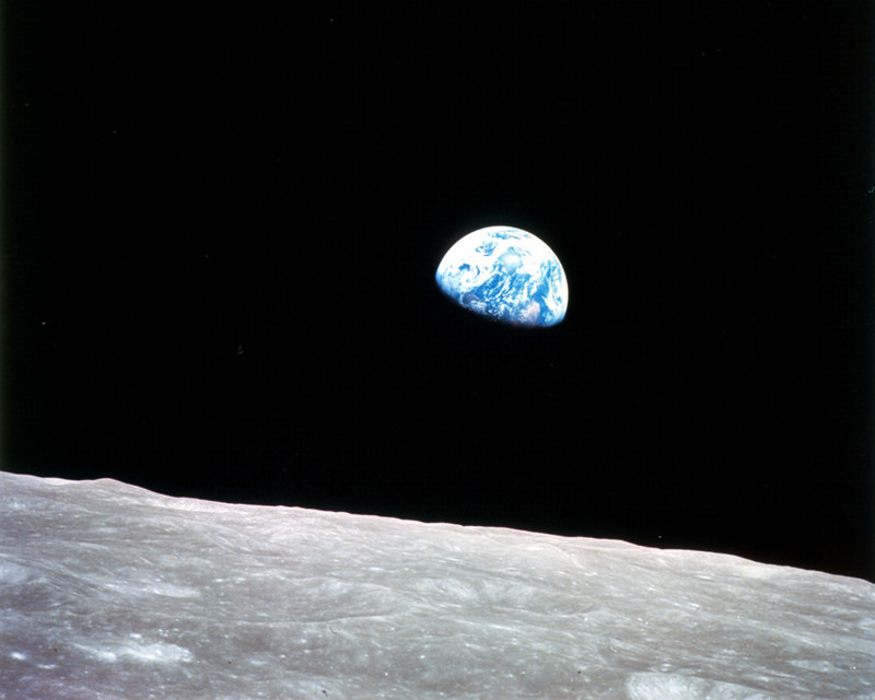
It was not until Apollo 8 was on its fourth orbit that Borman decided to roll the craft away from the Moon and to point its windows towards the horizon in order to get a navigational fix. A few minutes later, he spotted a blue-and-white object coming over the horizon. Transcripts of the Apollo 8 mission reveal the astronauts’ wonder and amazement at what they were seeing: Earth, from a quarter of million miles away, rising from behind the Moon. “Oh my God! Look at the picture over there. Here’s the Earth coming up,” Borman shouted. This was followed by a flurry of exclamations by Anders and Lovell and a scramble to find a camera. Anders found one first and the first image he took was black-and-white, showing Earth just peeping over the horizon. Then Anders found a roll of 70mm color film for the Hasselblad camera, and he took the photograph of Earthrise that became an icon of 20th-century, portraying technological advances and heightening ecological awareness.

Apollo 8 crew.  Credit: NASA
Apollo 8 crew. Credit: NASA

This was the way humans first recorded their home planet from another world. “It was the most beautiful, heart-catching sight of my life,” Borman said later, “one that sent a torrent of nostalgia, of sheer homesickness, surging through me. It was the only thing in space that had any color to it. Everything else was either black or white. But not the Earth.”

Jim Lovell said that Earth was “a grand oasis in the vast loneliness of space.”

The three astronauts agree the most important thing they brought back from the mission was the photography, not only of the moon, but of Earth.

To commemorate the 40th anniversary of Apollo 8, the crew of the International Space Station’s Expedition 18, Commander Mike Fincke and Flight Engineers Sandy Magnus and Yury Lonchakov will send a message to be aired on a message that will air on NASA Television as part of the daily Video File, beginning at 11 a.m. CST, Friday, Dec. 19. The video also will be broadcast in high definition on the NASA TV HD channel at 10
a.m., noon and 3 p.m. on Friday, Dec. 19, and Tuesday, Dec. 23.

Sources: NASA, The Guardian

Another Discovery Points to Past Water and Habitability on Mars

Carbonates appear in green in this area about 20 km (12 miles) wide on Mars. NASA/JPL/JHUAPL/MSSS/Brown University

[/caption]
Scientists from the Mars Reconnaissance Orbiter have made a major discovery about the history of water on Mars. The CRISM instrument, the Compact Reconnaissance Imaging Spectrometer for Mars, on board NASA’s Mars Reconnaissance Orbiter has found carbonates, a long-sought-after mineral, embedded in bedrock on the Martian surface. The Phoenix Mars Lander also discovered carbonates in soil samples, which was a surprise and MRO has observed carbonates in windblown dust from orbit. However, the dust and soil could be mixtures from many areas, so the carbonates’ origins have been unclear. The latest observations indicate carbonates may have formed over extended periods on early Mars. Additionally the new findings indicate that Mars had neutral to alkaline water when the minerals formed at these locations more than 3.6 billion years ago, and not the acidic soil that appears to dominate the planet today. This means that different types of watery environments have existed on Mars. The greater the variety of wet environments, the greater the chances one or more of them may have supported life.

“We’re excited to have finally found carbonate minerals because they provide more detail about conditions during specific periods of Mars’ history,” said Scott Murchie, principal investigator for the instrument at the Johns Hopkins University Applied Physics Laboratory in Laurel, Md.

Carbonate rocks are created when water and carbon dioxide interact with calcium, iron or magnesium in volcanic rocks. Carbon dioxide from the atmosphere becomes trapped within the rocks. If all of the carbon dioxide locked in Earth’s carbonates were released, our atmosphere would be thicker than that of Venus. Some researchers believe that a thick, carbon dioxide-rich atmosphere kept ancient Mars warm and kept water liquid on its surface long enough to have carved the valley systems observed today.

“The carbonates that CRISM has observed are regional rather than global in nature, and therefore, are too limited to account for enough carbon dioxide to form a thick atmosphere,” said Bethany Ehlmann, lead author of the article and a spectrometer team member from Brown University, Providence, R.I.

On Earth, carbonates include limestone and chalk, which dissolve quickly in acid.

“Although we have not found the types of carbonate deposits which might have trapped an ancient atmosphere,” Ehlmann said, “we have found evidence that not all of Mars experienced an intense, acidic weathering environment 3.5 billion years ago, as has been proposed. We’ve found at least one region that was potentially more hospitable to life.”

Possible carbonates in Nilli Fossae. Credit: NASA/JPL/University of Arizona

The researchers report clearly defined carbonate exposures in bedrock layers surrounding the 1,489-kilometer-diameter (925-mile) Isidis impact basin, which formed more than 3.6 billion years ago. The best-exposed rocks occur along a trough system called Nili Fossae, which is 666 kilometers (414 miles) long, at the edge of the basin. The region has rocks enriched in olivine, a mineral that can react with water to form carbonate.

“This discovery of carbonates in an intact rock layer, in contact with clays, is an example of how joint observations by CRISM and the telescopic cameras on the Mars Reconnaissance Orbiter are revealing details of distinct environments on Mars,” said Sue Smrekar, deputy project scientist for the orbiter at NASA’s Jet Propulsion Laboratory in Pasadena, Calif.

The findings will appear in the Dec. 19 issue of Science magazine and were announced Thursday at a briefing at the American Geophysical Union’s Fall Meeting in San Francisco.

Source: NASA

How to Drive the Mars Rovers, Part 1: Rover Updates

Rover Driver Scott Maxwell with a model of MER. Photo courtesy Scott Maxwell

[/caption]
In January of 2004, NASA’s twin robot geologists, the Mars Exploration Rovers Spirit and Opportunity, landed on the Red Planet. During those nearly five years, the rovers have returned hundreds of thousands of images and enough data to keep scientists busy for decades. But almost nine years ago, Scott Maxwell started working on developing software and techniques for driving the rovers around on Mars surface. Today he’s the Mars Rover Driver Team Lead for MER at JPL, and he says that every day of working on this mission has been incredible. “It’s been an amazing experience,” he said, “and I like to say it’s the best job on two planets.” To celebrate the upcoming fifth anniversary of the rovers on Mars, Universe Today caught up with Scott to get an update on the current status of the two rovers, to find out what the five-year MER mission has been like for a rover driver, and to ask the pressing question, just how do you drive a rover from 150 million kilometers away?

Both rovers have been inactive recently because of solar conjunction, where the sun is between Earth and Mars, which makes communications difficult because the amount of radio noise generated by the Sun. So, when I talked to Scott on Wednesday of this week he was just working on the commands that would be sent to Spirit for the first drive she has taken since several weeks ago. So how is Spirit doing these days?

“Spirit is struggling valiantly to climb up the north face of Home Plate,” Scott said. “As you know, we’ve just come out of solar conjunction, and so we’re picking up where we left off on Spirit’s climb up the face. Her solar array energy levels are not as good as they were before the mini-dust storm we had before the conjunction, so that’s obviously a cause for concern. It’s unfortunate because that means we have less energy for driving. But she’s still alive and that’s a lot better than what we thought she’d be five years into the mission.”

Home Plate is the raised plateau.  Spirit is the dark spot at the 1 o'clock position.  Image: NASA/JPL/University of Arizona
Home Plate is the raised plateau. Spirit is the dark spot at the 1 o'clock position. Image: NASA/JPL/University of Arizona

Home Plate is a low plateau about 80 meters (260 feet) in diameter. Spirit spent the Martian winter parked on the north side of the plateau with her solar panels slanted towards the low sun in order to stay alive. But Spirit’s solar arrays are severely dust-covered, decreasing the amount of power available for science activities and driving. But the scientists and engineers haven’t given up on Spirit, and still have big plans for her.

“Our longer term goal is to head south from Home Plate to a pair of features called ‘Goddard’ and ‘Von Braun’,” said Scott. “Von Braun is a hill and Goddard is a crater-like feature next to it, and that’s the next area we’d like to explore. As you know, the area around home plate appears to be a region of past hot-springs or volcanic fumarole activity, the kind of place where life might have formed on Earth, so it makes it a particularly exciting place to explore on Mars, as we try to find out more about what was going on here.”

But ‘Goddard’ and ‘Von Braun’ are on the south side of Home Plate and Spirit is on the north side. The easiest route would be to “climb back up on the top of Home Plate and kind of skate across it where the driving is good” Scott said, but if Spirit isn’t able to make the climb, they will drive down the north slope and go around Home Plate the long way. But that might take more time, and time might be getting limited for Spirit.

Bonestell panorama, taken by Spirit during her winter stay on the north side of Home Plate.  Credit:  NASA/JPL/Cornell
Bonestell panorama, taken by Spirit during her winter stay on the north side of Home Plate. Credit: NASA/JPL/Cornell

So, the shortest way is up and over Home Plate. But Spirit has a bum right front wheel, and is trying to climb up some difficult terrain. “Imagine you’re in the desert, climbing up a sand dune, but every step you take the sand crumbles out from beneath you,” said Scott. “That’s what Spirit is experiencing. So even though we’re commanding the wheels to go several meters, she might only make a few centimeters of progress in a sol (Martian Day).”

But the driving team will keep trying, as ‘Von Braun’ and ‘Goddard’ are of interest to the science team.

Opportunity, on the other hand, is in very different driving conditions. “Right now she’s basically on a parking lot, with only a couple of speed bumps every once in awhile,” Scott said. “Opportunity can drive 100 meters a sol, like the length of a football field every day, without breaking a sweat. We recently had a nearly record-setting drive, with Opportunity where we drove nearly 216 meters in one day,” Scott said proudly. “So that’s our silver medal drive, our second longest drive ever with either of the rovers.” (The longest drive was 220 meters in one day.)

One thing Opportunity does have to watch out for is sand dunes in the region. In 2005, Opportunity became stuck in one of those dunes, and it took the rover driving team over a month to figure out how to maneuver Opportunity out of the sand trap, called Purgatory Dune. In honor of the difficulties and lessons learned from getting stuck, all the potential sand traps in the region are called “Purgatoids.”
The "Purgatory" dunes around Opportunity.  Credit: NASA/JPL/Cornell
“Opportunity is in a region where Purgatiods are all around her.” Scott said. “But the good news is that we have better data now, than we did when we first encountered these features.” The MER team now has the benefit of the Mars Reconnaissance Orbiter’s HiRISE Camera in orbit around Mars, looking down at — if not watching over – the rovers and their activities. “So we have the data and images from HiRISE, and we think we have identified a way to pick out these Purgatoids from orbit.” Scott said. “So we take the images from MRO, and use them as part of our path planning for Opportunity every day, and also for our longer scale path planning. On top of that we have other measures we have adopted after that first Purgatory incident, where the rover stops every once in awhile and ‘checks’ itself, gauging whether it is actually moving or if it is stuck and the wheels are just spinning. So even if we get into a Purgatoid, we’ll be able to catch it before too long and have the chance to get ourselves out before we dig in too far.”

But so far, with the new technique of being able to identify Purgatoids from orbit, Opportunity hasn’t run into a single one.

Opportunity's traverse map through Sol 1716 As of sol 1707 (Nov. 11, 2008), Opportunity's total odometry was 13,493.85 meters (8.38 miles).

“It makes us happy to put the pedal to the metal and just drive,” Scott said, “It’s a lot of fun.”

Opportunity is “putting the hammer down” to reach a crater about 12 kilometers (7 miles) away called Endeavour. The huge crater is 22 kilometers (13.7 miles) across, and scientists expect to see a much deeper stack of rock layers than Opportunity saw while she was in Victoria Crater the past two years. The 12 km driving distance would match the total distance it has traveled from 2004 to mid-2008. Even at the 100-meter plus pace each sol, the journey could take two years.

But Scott Maxwell and the 13 other rover drivers working on the MER mission are up for the challenge.

Tomorrow: Part 2: Just how do you drive a rover on another planet?
How to Drive a Mars Rover, Part 3

Jupiter’s Moon Plays Hide-and-Seek with Hubble

Ganymede is about to hide behind Jupiter. Credit: NASA, ESA, and E. Karkoschka (University of Arizona)

[/caption]
NASA’s Hubble Space Telescope has caught Jupiter’s moon Ganymede playing a game of hide-and-seek. In this crisp Hubble image, Ganymede is shown just before it hides behind the giant planet. Images like this one are not only gorgeous and enjoyable to look at, but are also useful for studying Jupiter’s upper atmosphere. As Ganymede passes behind the giant planet, it reflects sunlight, which then passes through Jupiter’s atmosphere. Imprinted on that light is information about the gas giant’s atmosphere, which yields clues about the properties of Jupiter’s high-altitude haze above the cloud tops. And because Hubble’s view is so sharp, we can learn more about Ganymede as well. Visible are several features on the moon’s surface, most notably the white impact crater, Tros, and its system of rays, bright streaks of material blasted from the crater. Tros and its ray system are roughly the width of Arizona. Hubble has amazing eyesight!

And there’s a movie, too!

More about Ganymede and Jupiter…

Composed of rock and ice, Ganymede is the largest moon in our solar system. It is even larger than the planet Mercury. But Ganymede looks like a dirty snowball next to Jupiter, the largest planet in our solar system. Jupiter is so big that only part of its Southern Hemisphere can be seen in this image.
Ganymede completes an orbit around Jupiter every seven days. Because Ganymede’s orbit is tilted nearly edge-on to Earth, it routinely can be seen passing in front of and disappearing behind its giant host, only to reemerge later.

The image also shows Jupiter’s Great Red Spot, the large eye-shaped feature at upper left. A storm the size of two Earths, the Great Red Spot has been raging for more than 300 years. Hubble’s sharp view of the gas giant planet also reveals the texture of the clouds in the Jovian atmosphere as well as various other storms and vortices.

This color image was made from three images taken on April 9, 2007, with the Wide Field Planetary Camera 2 in red, green, and blue filters. The image shows Jupiter and Ganymede in close to natural colors.

Source: Hubblesite

Where In The Universe #34

Its time once again for another Where In The Universe Challenge. The goal of this challenge is to test your skills and knowledge of the cosmos. Guess where in the Universe this image is from, and give yourself extra points if you can guess which spacecraft is responsible for the image. Post your guess in the comment section (no links to hints please!) and check back tomorrow for the answer. Good luck, dress up for dinner, and have fun.

UPDATE (12/18): The answer has now been posted below. If you haven’t made your guess yet, no peeking before you do!!

Nice job this week, everyone (although I think my favorite answer was a wrong one by “Carl Sagan.”) This is Comet Shoemaker-Levy 9 (named after its co-discoverers), which is often referred to as the “string of pearls” comet. It is famous because it collided with the planet Jupiter: the comet’s original single nucleus was torn to pieces by Jupiter’s strong gravity. The pieces are seen in this composite of Hubble Space Telescope images to be “pearls” strung out along the comet’s orbital path. This image was taken in 1992, and in July of 1994 these pieces collided with Jupiter in a rare and spectacular series of events.

I’ll try to find a harder one next week, but …. I might be lenient since it will be close to the holidays!

Water ‘Way Out There

Detection of the earliest and most distant water. CREDIT: Milde Science Communication, STScI, CFHT, J.-C. Cuillandre, Coelum.

[/caption]
A long time ago in a galaxy far, far away there was water. Astronomers have found tell-tale signatures of water molecules in a galaxy more than 11 billion light years from Earth. Using the giant, 100-meter-diameter radio telescope in Effelsberg, Germany, along with the Very Large Array (VLA) in New Mexico, scientists detected the most distant water yet seen in the Universe. Previously, the most distant water had been seen in a galaxy less than 7 billion light-years from Earth. Since it is so far away, we’re actually seeing it as it was long ago; as when the Universe was one-sixth the age it is now. The astronomers were able to take advantage of two types of natural “amplification” to detect the water in this galaxy. The galaxy, dubbed MG J0414+0534 has a quasar — a supermassive black hole powering bright emission — at its core. In the region near the core, the water molecules are acting as masers, the radio equivalent of lasers, to amplify radio waves at a specific frequency. Additionally, another galaxy was used as a gravitational lens to magnify the radio signals used to detect the water molecules.

The astronomers say their discovery indicates that such giant water masers were more common in the early Universe than they are today. At the galaxy’s great distance, even the strengthening of the radio waves done by the masers would not by itself have made them strong enough to detect with the radio telescopes.

With the help of gravitational lensing from another galaxy, nearly 8 billion light-years away, located directly in the line of sight from MG J0414+0534 to Earth, the foreground galaxy’s gravity served as a lens to further brighten the more-distant galaxy and make the emission from the water molecules visible to the radio telescopes.

Effelsberg Telescope.

The astronomers first detected the water signal with the Effelsberg telescope. They then turned to the VLA’s sharper imaging capability to confirm that it was indeed coming from the distant galaxy. The gravitational lens produces not one, but four images of MG J0414+0534 as seen from Earth. Using the VLA, the scientists found the specific frequency attributable to the water masers in the two brightest of the four lensed images.

The radio frequency emitted by the water molecules was Doppler shifted by the expansion of the Universe from 22.2 GHz to 6.1 GHz.

“We were only able to discover this distant water with the help of the gravitational lens,” said Violette Impellizzeri, an astronomer with the Max-Planck Institute for Radioastronomy (MPIfR) in Bonn, Germany. “This cosmic telescope reduced the amount of time needed to detect the water by a factor of about 1,000,” she added.

Water masers have been found in numerous galaxies at closer distances. Typically, they are thought to arise in disks of molecules closely orbiting a supermassive black hole at the galaxy’s core. The amplified radio emission is more often observed when the orbiting disk is seen nearly edge-on. However, the astronomers said MG J0414+0534 is oriented with the disk almost face-on as seen from Earth.

“This may mean that the water molecules in the masers we’re seeing are not in the disk, but in the superfast jets of material being ejected by the gravitational power of the black hole,” explained John McKean, also of MPIfR.

The team’s paper will be published in the Dec. 18 edition of Nature.

Source: NRAO

Great Space Shuttle Pictures

Shuttle Endeavour catches a ride from a 747. Image Credit: NASA/Carla Thomas

[/caption]
Say what you want about the space shuttle program, but one thing is for certain: the shuttle is very photogenic. This very nifty image was taken by a chase plane looking down as a Boeing 747 airplane ferried Space Shuttle Endeavour from California to Florida on Dec. 10, 2008, and is today’s NASA picture of the day. The backdrop is the Mojave Desert in California. This image got me looking for other interesting pictures of the space shuttle, and so I’ve compiled a few here.
Interesting Update: Just after posting this, I came across a news release from NASA that they are soliciting ideas for displaying the space shuttles after they are retired!

Space shuttle on approach to ISS.  Credit: NASA
Space shuttle on approach to ISS. Credit: NASA

Here Space Shuttle Discovery is approaching the International Space Station in February 2003 during the pitch maneuver that allows the station crew to photograph the entire shuttle to look for any possible damage from launch debris. Breathtaking!

Space Shuttle's tail and Earth's limb.  Credit: NASA
Space Shuttle's tail and Earth's limb. Credit: NASA

This unique image is of the space shuttle’s tail with the limb of Earth’s atmosphere in the background.
Space Shuttle Challenger in 1983.  Credit:  NASA.
Space Shuttle Challenger in 1983. Credit: NASA.

Space Shuttle Challenger taken with a 70mm camera onboard a satellite that the shuttle brought up to space. It was taken in 1983, and so is from one of the early shuttle flights. NASA has since abandoned having their cameras put crosshairs on their images, which makes them less scienc-y and more just, wow.

Space Shuttle sonic boom.

I found this image in several places around the web, but I don’t know who actually took the image. Anyone have a clue who to credit for this image? Its the space shuttle just as its is going through the sound barrier.
Endeavour landing.  Credit: NASA
Endeavour landing. Credit: NASA

This is a beautiful night landing of Space Shuttle Endeavour, and its one of my favorite shuttle images. If anyone has any more favorite shuttle images, feel free to post the links!

Spaceport America Closer to Reality

Artist's concept of the New Mexico's Spaceport America. Courtesy NMSA

[/caption]
If you’re thinking about booking flight on Virgin Galactic’s SpaceShip Two, launching a payload with UP Aerospace or Armadillo Aerospace, or can’t wait to watch the Rocket Racing League, you’ll be happy to know New Mexico’s Spaceport America is two steps closer to becoming a reality and not just a dream. An environmental impact study on the facility was completed and approved, which set the stage for the FAA (Federal Aviation Administration) to be able to issue a launch license to the New Mexico Spaceport Authority (NMSA). The license is for both vertical and horizontal launches. “These two governmental approvals are the next steps along the road to a fully operational commercial spaceport,” said NMSA Executive Director Steven Landeene. Now, with license in hand, construction can begin on the futuristic-looking spaceport facility. Is the future and potential of commercial/personal spaceflight actually getting closer?

Several launches of smaller commercial rockets have already launched from the New Mexico site since April 2007, but now the spaceport can get ready for the “bigger” commercial rockets and commercial spacecraft that will launch the first paying customers in to suborbital space.

Landeene said bids will go out in January for the roads, runway and security buildings. The terminal and hangar are still in the design phase so those bids will go out sometime in the spring. “We could not pursue anything on site until this record of decision was received,” said Landeene. The NMSA currently projects vertical launch activity to increase in 2009 and construction to also begin in 2009 with the terminal and hangar facility for horizontal launches completed by late 2010.

Cross section of Spaceport America.  Courtesy of NMSA
Cross section of Spaceport America. Courtesy of NMSA

“We are on track to begin construction in the first quarter of 2009, and have our facility completed as quickly as possible,” he said. The NMSA is expected to sign a lease agreement with Virgin Galactic before the end of 2008.

“It’s an important day for New Mexico and the nation as Spaceport America now adds to the United States’ launch infrastructure,” said Daniela Glick, Chair of the NMSA Board. The NMSA says Spaceport America is now positioned to become the nation’s leading commercial spaceport facility. Spaceport America has been working closely with leading aerospace firms such as Virgin Galactic, Lockheed Martin, Rocket Racing Inc./Armadillo Aerospace, UP Aerospace, Microgravity Enterprises and Payload Specialties.

Sources: KFOX TV, NMSA

Today is Wright Brothers Day

Wright Flyer. Credit: Wikipedia

Almost all of us take for granted that we can get to virtually any destination in the world by flying in an airplane. We routinely board an aircraft, grumble at the slightest delay, and complain when we don’t get any peanuts during the flight. But really, we should be amazed in wonderment as each airplane takes off and lands.

It’s almost a miracle: we can sit in a somewhat comfortable chair, sleep, read a book or watch a movie, and three hours later, we’ve flown across the country. And it all began 105 years ago. On December 17, 1903 the Wright brothers, Orville and Wilbur, made the first successful controlled, powered and sustained flight of an aircraft.

Orville flew for 12 seconds, covering 120 feet (36.5m), at a speed of only 6.8 mph from level ground into a cold headwind gusting to 27 miles (43 km) an hour. The flight was recorded in the famous photograph, above. Then, to prove it wasn’t a fluke, they flew two more times: Wilbur flew approximately 175 feet (53 m), and then Orville took the controls again and flew 200 feet (60 m).

Their altitude was about 10 ft above the ground. Although not the first to build and fly experimental aircraft, the Wright brothers were the first to invent aircraft controls – a three-axis control – that made it possible for a pilot to control the aircraft and made fixed wing flight possible.

Every year since 1963 the US Congress proclaims Dec. 17 as Wright Brother’s Day, and the US President signs the proclamation (read below). Here is Orville Wright’s account of the final flight of the day:

“Wilbur started the fourth and last flight at just about 12 o’clock. The first few hundred feet were up and down, as before, but by the time three hundred feet had been covered, the machine was under much better control. The course for the next four or five hundred feet had but little undulation. However, when out about eight hundred feet the machine began pitching again, and, in one of its darts downward, struck the ground. The distance over the ground was measured to be 852 feet (260 m); the time of the flight was 59 seconds. The frame supporting the front rudder was badly broken, but the main part of the machine was not injured at all. We estimated that the machine could be put in condition for flight again in about a day or two.”

The proclamation of Wright Brothers Day :

“Our history is rich with pioneers and innovators who used their God-given talents to improve our Nation and the world. On Wright Brothers Day, we commemorate two brothers, Orville and Wilbur Wright, who took great risks and ushered in a new era of travel and discovery.

With intrepid spirits and a passion for innovation, Orville and Wilbur Wright became the first to experience the thrill of manned, powered flight. On December 17, 1903, Orville Wright flew for 12 seconds over the North Carolina sand dunes in the presence of only five people. In the span of one lifetime, our Nation has seen aviation progress from the first tentative takeoff at Kitty Hawk to an age of supersonic flight and space exploration.

On this Wright Brothers Day, we recognize all those who have taken great risks and contributed to our country’s legacy of exploration and discovery. This year, we also celebrate the centennial of the world’s first passenger flight. By remaining dedicated to extending the frontiers of knowledge, we can ensure that the United States will continue to lead the world in science, innovation, and technology, and build a better future for generations to come.

The Congress, by a joint resolution approved December 17, 1963, as amended (77 Stat. 402; 36 U.S.C. 143), has designated December 17 of each year as “Wright Brothers Day” and has authorized and requested the President to issue annually a proclamation inviting the people of the United States to observe that day with appropriate ceremonies and activities.

NOW, THEREFORE, I, GEORGE W. BUSH, President of the United States of America, do hereby proclaim December 17, 2008, as Wright Brothers Day.

IN WITNESS WHEREOF, I have hereunto set my hand this sixteenth day of December, in the year of our Lord two thousand eight, and of the Independence of the United States of America the two hundred and thirty-third.

GEORGE W. BUSH “

More Thoughts (and now math!) On What Came Before the Big Bang

CMB Timeline. Credit: NASA

[/caption]
Physicist Sean Carroll gave a wonderful talk at the June 2008 American Astronomical Society meeting about his “speculative research” on what possibly could have existed before The Big Bang. (Here’s an article about Carroll’s talk.) But now Carroll and some colleagues have done a bit more than just speculate about what might have come before the beginning of our Universe. Carroll, along with Caltech professor Marc Kamionkowski and graduate student Adrienne Erickcek have created a mathematical model to explain an anomaly in the early universe, and it also may shed light on what existed before the Big Bang. “It’s no longer completely crazy to ask what happened before the Big Bang,” said Kamionkowski.

Inflation theory, first proposed in 1980, states that space expanded exponentially in the instant following the Big Bang. “Inflation starts the universe with a blank slate,” Erickcek describes. The problem with inflation, however, is that it predicts the universe began uniformly.

But measurements from Wilkinson Microwave Anisotropy Probe (WMAP) show that the fluctuations in the Cosmic Microwave Background (CMB) –the electromagnetic radiation that permeated the universe 400,000 years after the Big Bang — are about 10% stronger on one side of the sky than on the other.

WMAP map of the CMB.  Credit:  WMAP team
WMAP map of the CMB. Credit: WMAP team

“It’s a certified anomaly,” Kamionkowski remarks. “But since inflation seems to do so well with everything else, it seems premature to discard the theory.” Instead, the team worked with the theory in their math addressing the asymmetry, since one explanation for this “heavy-on-one-side universe” would be if these fluctuations represented a structure left over from something that produced our universe.

They started by testing whether the value of a single energy field thought to have driven inflation, called the inflaton, was different on one side of the universe than the other. It didn’t work–they found that if they changed the mean value of the inflaton, then the mean temperature and amplitude of energy variations in space also changed. So they explored a second energy field, called the curvaton, which had been previously proposed to give rise to the fluctuations observed in the CMB. They introduced a perturbation to the curvaton field that turns out to affect only how temperature varies from point to point through space, while preserving its average value.

The new model predicts more cold than hot spots in the CMB, Kamionkowski says. Erickcek adds that this prediction will be tested by the Planck satellite, an international mission led by the European Space Agency with significant contributions from NASA, scheduled to launch in April 2009.

For Erickcek, the team’s findings hold the key to understanding more about inflation. “Inflation is a description of how the universe expanded,” she adds. “Its predictions have been verified, but what drove it and how long did it last? This is a way to look at what happened during inflation, which has a lot of blanks waiting to be filled in.”

But the perturbation that the researchers introduced may also offer the first glimpse at what came before the Big Bang, because it could be an imprint inherited from the time before inflation. “All of that stuff is hidden by a veil, observationally,” Kamionkowski says. “If our model holds up, we may have a chance to see beyond this veil.”

Source: Caltech