Dr. Ken Kremer is a speaker, research scientist, freelance science journalist (KSC area,FL) and photographer whose articles, space exploration images and Mars mosaics have appeared in magazines, books, websites and calendars including Astronomy Picture of the Day, NBC, FOX, BBC, SPACE.com, Spaceflight Now, Science and the covers of Aviation Week & Space Technology, Spaceflight and the Explorers Club magazines. Ken has presented at numerous educational institutions, civic & religious organizations, museums and astronomy clubs. Ken has reported first hand from the Kennedy Space Center, Cape Canaveral, NASA Wallops, NASA Michoud/Stennis/Langley and on over 80 launches including 8 shuttle launches. He lectures on both Human and Robotic spaceflight - www.kenkremer.com. Follow Ken on Facebook and Twitter
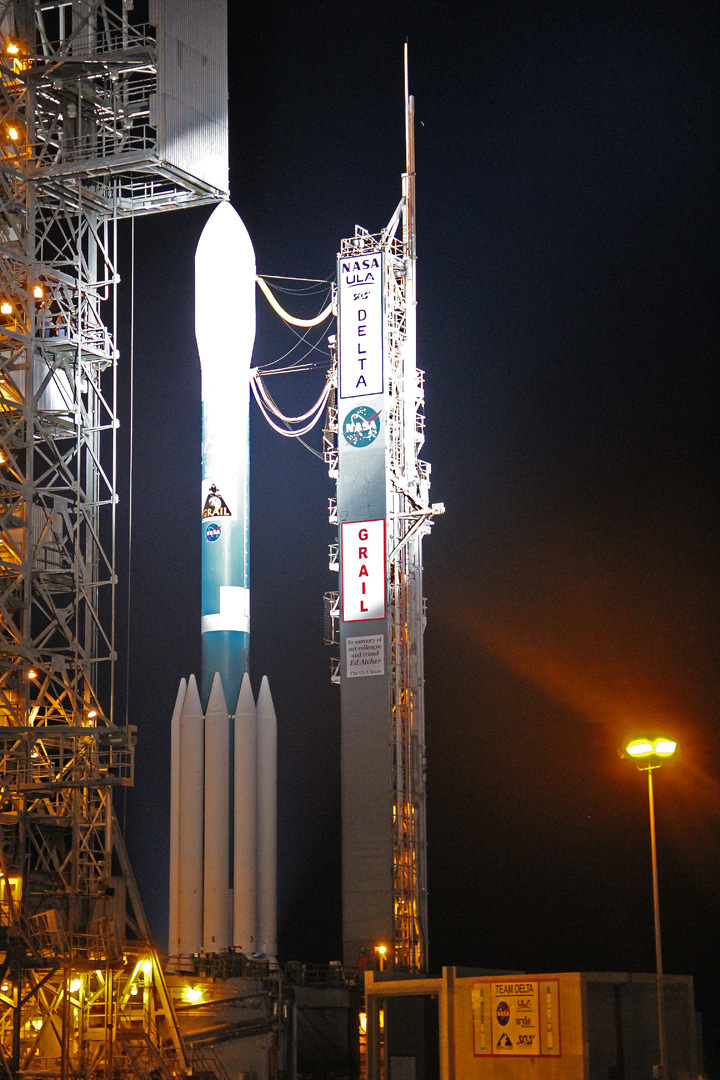
Blastoff of Delta II Heavy rocket and twin GRAIL Lunar Mappers on Sept 10 blast off unveiled at night at Launch Pad 17B. GRAIL liftoff was postponed to Sept. 10 at 8:29 a.m EDT after high levels winds scrubbed the Sept 8 launch attempt. Credit: Ken Kremer
[/caption]
NASA renewed its focus on ground breaking science today with the thunderous blastoff of a pair of lunar bound spacecraft that will map the moons interior with unparalled precision and which will fundamentally alter our understanding of how the moon and other rocky bodies in our solar system – including Earth – formed and evolved over 4.5 Billion years.
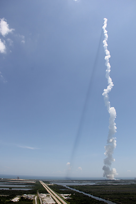
Today’s (Sept. 10) launch of the twin lunar Gravity Recovery and Interior Laboratory (GRAIL) spacecraft atop the mightiest Delta II rocket from Cape Canaveral Air Force Station in Florida at 9:08 a.m. EDT was a nail biter to the end, coming after a two day weather delay due to excessively high upper level winds that scrubbed the first launch attempt on Sept. 8, and nearly forced a repeat cancellation this morning.
Liftoff of the nearly identical GRAIL A and B lunar gravity mappers from Space Launch Complex 17B took place on the second of two possible launch attempts after the first attempt was again waived off because the winds again violated the launch constraints.
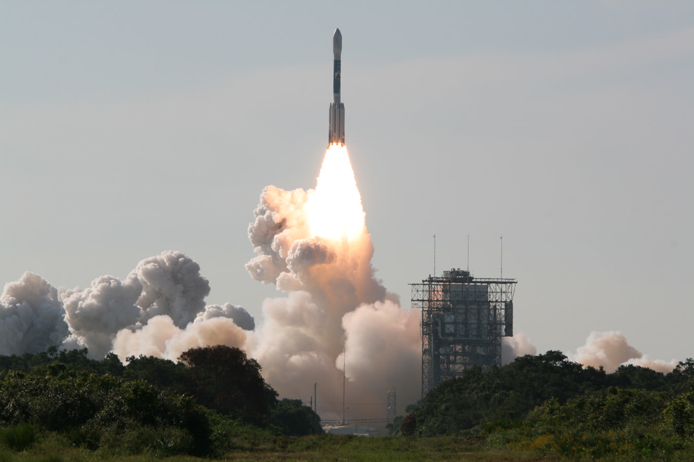
GRAIL A and B gravity mappers rocket to the moon atop a Delta II Heavy booster on Sept. 10 from Cape Canaveral, Florida. View to Space Launch Complex 17 gantry from Press Site 1.
Credit: Ken Kremer (kenkremer.com)
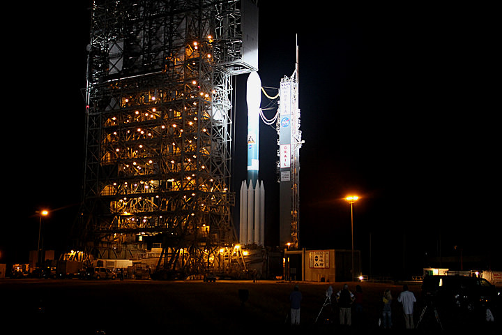
After the final “GO” was given, the Delta II Heavy booster suddenly roared to life and put on a spectacular show spewing smoke, flames and ash as it pushed off the pad and shot skywards atop a rapidly growing plume of exhaust and rumbling thunder into a nearly cloudless sky.
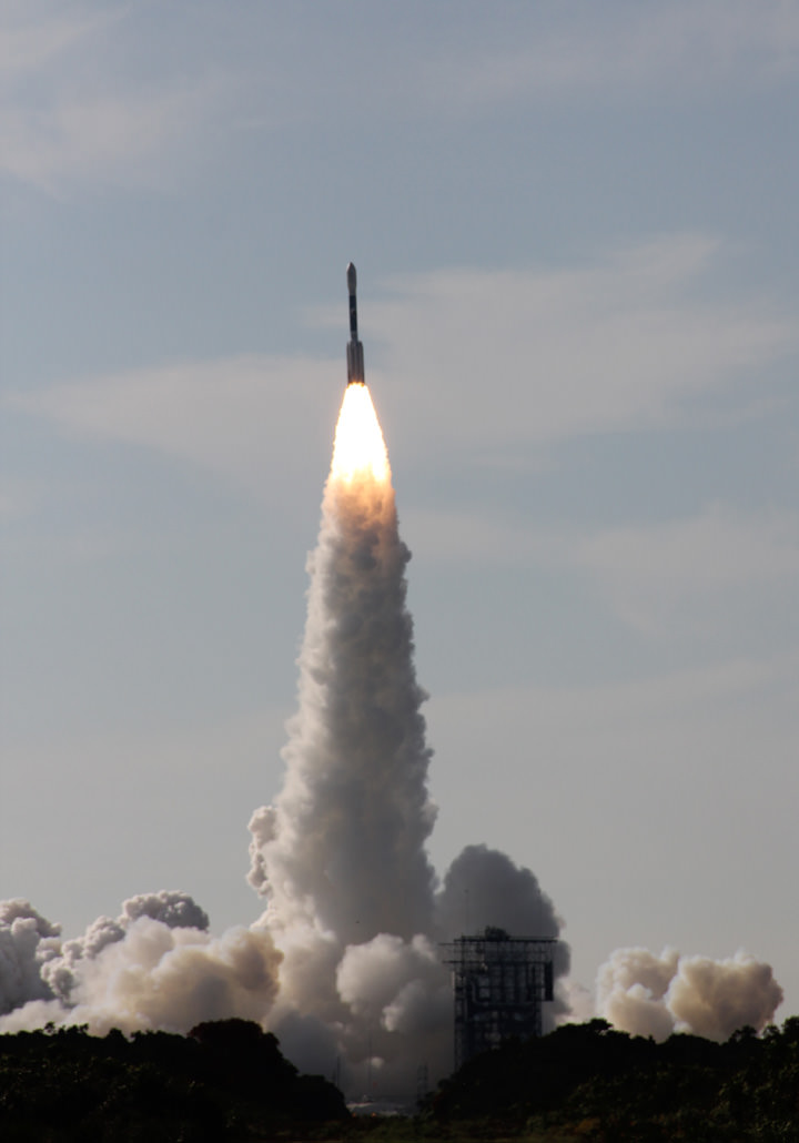
The solar powered dynamic duo were propelled to space by the last ever Delta II rocket slated to depart Earth from Cape Canaveral, Florida. After more than 50 years of highly reliable service starting in 1960, the venerable Delta II family will be retired after one final launch in October from Vandenberg Air Force Base in California.
GRAIL and Delta II rocket soar to space.
View to Space Launch Complex 17 Pad A & Pad B (right) from Press Site 1. Credit: Ken Kremer
On this special occasion the media were allowed to a witness the launch from Press Site 1 – a location just 1.5 miles away from the pad with a gorgeous and unobstructed view to the base of the pad which magnified the tremendous roar of the rocket engines.
“Since the earliest humans looked skyward, they have been fascinated by the moon,” said GRAIL principal investigator Maria Zuber from the Massachusetts Institute of Technology in Cambridge. “GRAIL will take lunar exploration to a new level, providing an unprecedented characterization of the moon’s interior that will advance understanding of how the moon formed and evolved.”
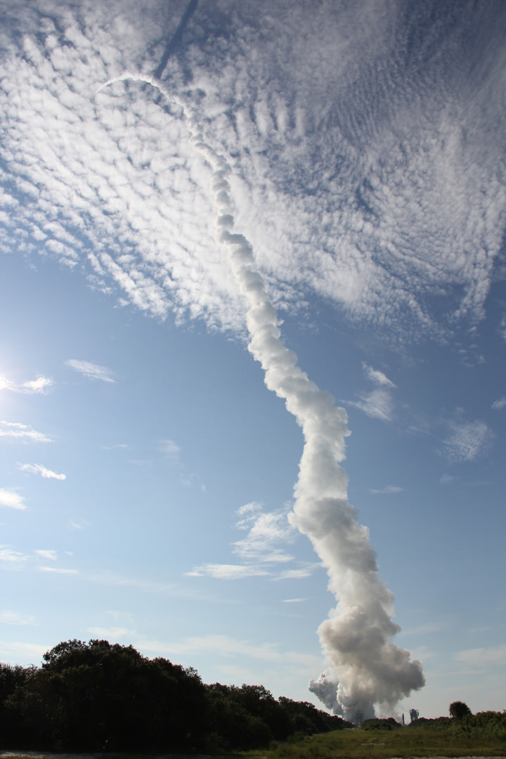
Delta II arcs over atop long exhaust plume casting shadow for long lunar journey. Credit: Ken Kremer
The spacecraft separation and deployment of the solar arrays worked exactly as planned, the mission team reported at a post launch briefing for reporters. Both probes are power positive and healthy.
GRAIL A and B are now speeding towards the moon on a low energy path that will take about 3.5 months compared to just three days for the Apollo astronauts. The slower and longer path covering more than 2.5 million miles (4 million kilometers) enables the spacecraft to use a smaller engine and carry less fuel for the braking maneuver required to place the probes into a polar elliptical orbit when they arrive at the moon about 25 hours apart on New Year’s Eve and New Year’s Day 2012.
“Our GRAIL twins have Earth in their rearview mirrors and the moon in their sights,” said David Lehman, GRAIL project manager at NASA’s Jet Propulsion Laboratory (JPL) in Pasadena, Calif. “The mission team is ready to test, analyze and fine-tune our spacecraft over the next three-and-a-half months on our journey to lunar orbit.”
During the 82 day science phase, the primary objective of is to study the moons interior from crust to core and map its gravity field by 100 to 1000 times better than ever before. GRAIL A and GRAIL B will fly in tandem formation in near circular polar orbit at an altitude of some 50 km above the lunar surface as the moon rotates beneath three times.
GRAIL lunar twins depart Earth for the Moon
All 3 Air-lit solids have ignited after all 6 ground lit solids have been jettisoned.Credit: Ken Kremer
The mission will provide unprecedented insight into the structure and composition of moon from crust to core, unlock the mysteries of the lunar interior and advance our understanding of the thermal evolution of the moon that can be applied to the other terrestrial planets in our solar system, including Mercury, Venus, Earth and Mars.
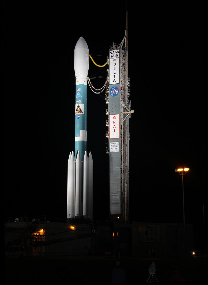
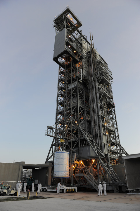
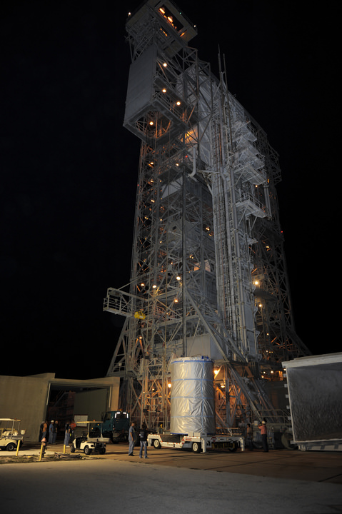
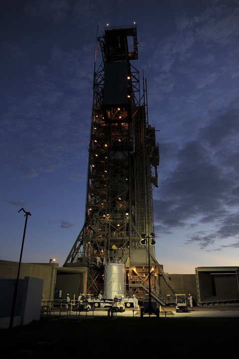
Delta II Heavy rocket and GRAIL Lunar mappers unveiled at night at Launch Pad 17B. GRAIL liftoff was postponed to Sept. 10 at 8:29 a.m EDT after high levels winds scrubbed the Sept 8 launch attempt. Credit: Ken Kremer
[/caption]
NASA’s Gravity Recovery and Interior Laboratory (GRAIL) moon mapping twins and the mighty Delta II rocket that will blast the high tech physics experiment to space on a lunar science trek were magnificently unveiled in the overnight darkness in anticipation of a liftoff that had originally been planned for the morning of Sept. 8.
Excessively high upper level winds ultimately thwarted Thursday’s launch attempt.
NASA late today has just announced a further postponement by another day to Saturday Sept. 10 to allow engineers additional time to review propulsion system data from Thursday’s detanking operation after the launch attempt was scrubbed to Friday. Additional time is needed by the launch team to review the pertinent data to ensure a safe blastoff of the $496 Million GRAIL mission.
There are two instantaneous launch opportunities at 8:29:45 a.m. and 9:08:52 a.m. EDT at Cape Canaveral, eight minutes earlier than was planned on Sept. 8. The weather forecast for Sept. 10 still shows a 60 percent chance of favorable conditions for a launch attempt.
GRAIL A and B enclosed in nose cone atop Delta II rocket at Cape Canaveral, Florida. Umbilical’s connect from Delta 2 to Fixed Umbilical Tower (FUT).
Credit: Ken Kremer (kenkremer.com)
Despite a rather poor weather prognosis, the heavy space coast cloud cover had almost completely cleared out in the final hours before launch, the surface winds were quite calm and we all expected to witness a thunderous liftoff. But measurements from weather balloons sent aloft indicated that the upper level winds were “red” and violated the launch criteria.
Mobile Service Tower is retracted from around Delta II rocket at Pad 17B. Credit: Ken Kremer
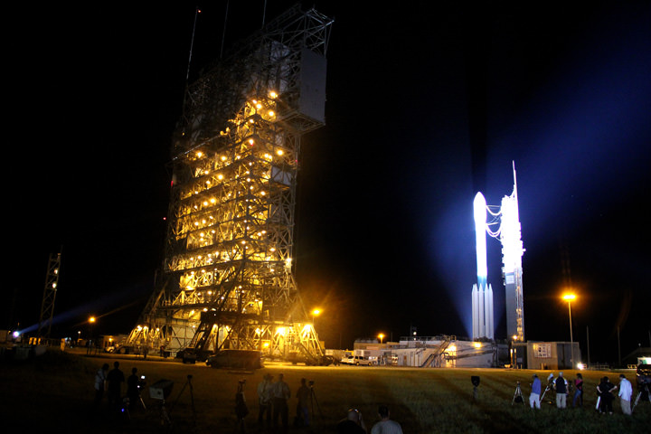
As the launch gantry was quickly retracted at Launch Complex 17B on Sept. 7, the Delta was bathed in xenon spotlights that provided a breathtaking light show as the service structure moved a few hundred feet along rails.
The cocoon like Mobile Service Tower (MST) provides platforms to access the rocket at multiple levels to prepare the vehicle and spacecraft for flight. The MST also protects the rocket from weather and impacts from foreign debris.
The Delta II rocket stands 128 feet tall and is 8 feet in diameter. The first stage liquid and solid rocket fueled engines will generate about 1.3 million pounds of thrust.
During the Terminal Countdown, the first stage is fueled with cryogenic liquid oxygen and highly refined kerosene (RP-1).
GRAIL is an extraordinary first ever journey to the center of the moon that will — with its instruments from orbit — peer into the moons interior from crust to core and map its gravity field by 100 to 1000 times better than ever before. The mission employs two satellites flying in tandem formation some 50 km in near circular polar orbit above the lunar surface.
GRAIL A and B will perform high precision range-rate measurements between them using a Ka-band instrument. The mission will provide unprecedented insight into the formation and thermal evolution of the moon that can be applied to the other rocky planets in our solar system: Mercury, Venus, Earth and Mars.
After a 3.5 month journey to the moon, the probes will arrive about a day apart on New Year’s Eve and New Year’s Day 2012 for an 82 day science mapping phase as the moon rotates three times beneath the GRAIL orbit.
Photojournalists watch as Mobile Service Tower is retracted from around Delta II rocket at Pad 17B.
Credit: Ken Kremer Xenon spotlights bathe Delta II rocket as Mobile Service Tower is retracted at Pad 17 and photojournalists watch from nearby at Pad 17B. Credit: Ken Kremer
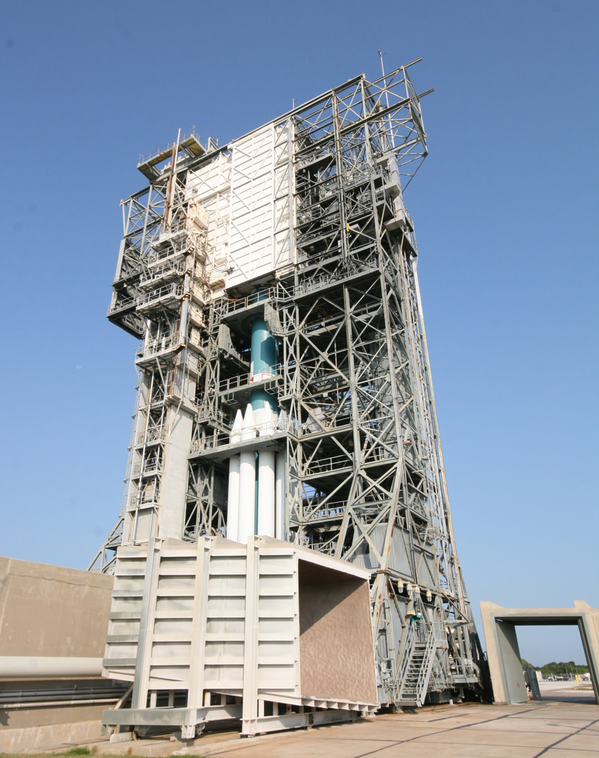
Delta II Heavy rocket will blast GRAIL missions to the moon from Launch Pad 17B. Delta II rocket and twin GRAIL satellites are enclosed inside the Mobile Service Tower at Cape Canaveral Air Force Station. Credit: Ken Kremer
[/caption]
Another American rocket Era is about to end. The venerable Delta II rocket, steeped in history, will fly what is almost certainly its final mission from Cape Canaveral. And it will do so quite fittingly by blasting twin satellites to the moon for NASA on a unique path for a truly challenging mission to do “extraordinary science”.
On Sept. 8, the most powerful version of the Delta II, dubbed the Delta II Heavy, is slated to launch NASA’s duo of GRAIL lunar mappers on an unprecedented science mission to unlock the mysteries of the moons deep interior. There are two instantaneous launch windows at 8:37:06 a.m. and 9:16:12 a.m. EDT lasting one second each.
“GRAIL simply put, is a journey to the center of the moon,” said Ed Weiler, NASA Associate Administrator of the Science Mission Directorate in Washington,DC at a pre-launch briefing for reporters on Sept. 6.
“It will probe the interior of the moon and map its gravity field by 100 to 1000 times better than ever before. We will learn more about the interior of the moon with GRAIL than all previous lunar missions combined.”
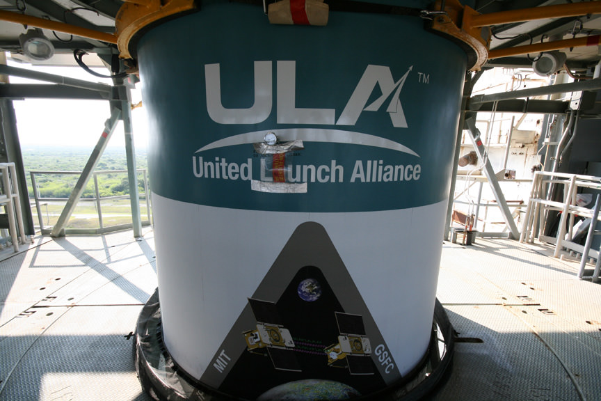
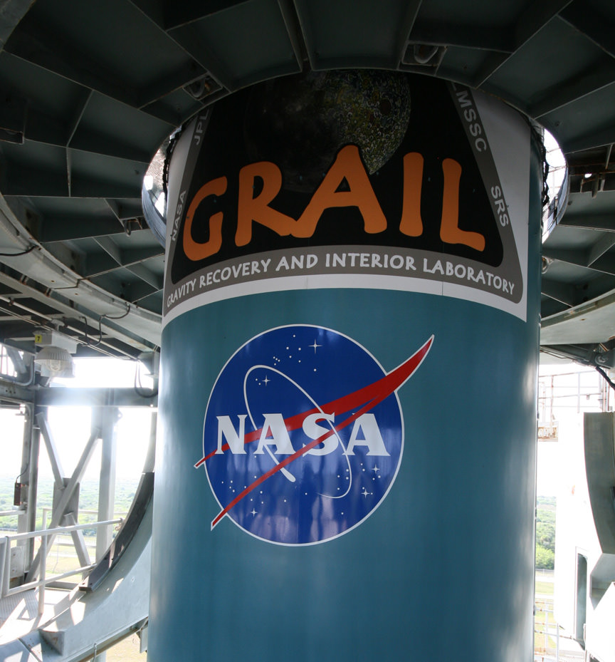
View of Delta II rocket looking out to Atlantic Ocean from upper level of Launch Complex 17. ULA and GRAIL logos painted on side of 8 ft diameter Delta rocket. Credit: Ken Kremer
GRAIL will depart Earth from Space Launch Complex 17B (SLC-17B) at Cape Canaveral Air Force Station, Florida, which is also the last scheduled use of Pad 17B.
GRAIL logo painted on the side of Delta II Rocket 1st Stage. Photo taken from inside upper level of launch gantry. GRAIL stands for Gravity Recovery and Interior Laboratory. Credit: Ken Kremer
“Trying to understand how the moon formed, and how it evolved over its history, is one of the things we’re trying to address with the GRAIL mission,” says Maria Zuber, principal investigator for GRAIL from the Massachusetts Institute of Technology. “But also, (we’re) trying to understand how the moon is an example of how terrestrial planets in general have formed.”
“GRAIL is a mission that will study the inside of the moon from crust to core,” Zuber says.
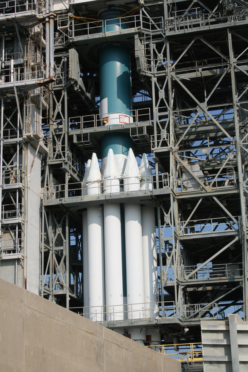
Delta II Heavy rocket is augmented by 9 wider diameter solid rocket motors providing more thrust. Credit: Ken Kremer
So far there have been 355 launches of the Delta II family, according to NASA’s Delta II Launch Manager Tim Dunn. The Delta II is built by United Launch Alliance.
“GRAIL is the last contracted Delta II mission to be launched from Complex 17. And it will be the 356th overall Delta to be launched. Complex 17 at the Cape has a proud heritage of hosting 258 of those 355 total Delta launches to date.
Hypergolic propellants have been loaded onto the 2nd stage after assessing all the preparations for the rocket, spacecraft, the range and facilities required for launch.
“The Launch Readiness Review was successfully completed and we can proceed with the countdown,” said Dunn.
The Delta II Heavy is augmented with nine larger diameter ATK solid rocket motors.
The Mobile Service Tower will be rolled back from the Delta II rocket tonight, starting at about 10:30 p.m. EDT depending on the weather.
The weather forecast for launch remains very iffy at a 60% percent chance of “NO GO” according to NASA and Air Force officials.
A launch decision will be made tomorrow morning Sept. 8 right after the weather briefing but before fueling begins at 6:30 a.m.
The weather forecast for rollback of the Mobile Service Tower tonight remains generally favorable. There is a 40% chance of a weather issue at 10:30 p.m. which drops to 30% after midnight. Tower rollback can be pushed back about 2 hours without impacting the countdown, says NASA.
Weather remains at 60% NO GO in case of a 24 hour delay but improves over the weekend. The team has about 42 days time in the launch window.
After entering lunar orbit, the two GRAIL spacecraft will fly in a tandem formation just 55 kilometers above the lunar surface with an average separation of 200 km during the three month science phase.
Stay tuned to Universe Today for updates overnight leading to liftoff at 8:37 a.m.
See my photo album from a recent tour of Launch Complex 17 and the Mobile Service Tower
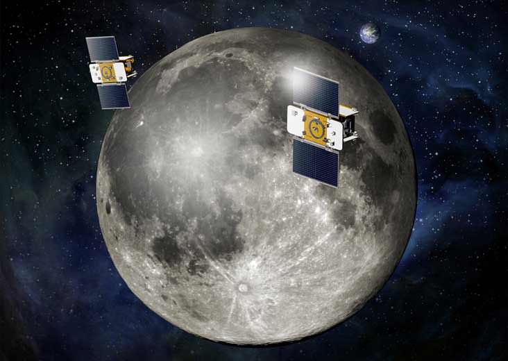
GRAIL Flying in Formation. Using a precision formation-flying technique, the twin GRAIL spacecraft will map the moon's gravity field. The mission also will answer longstanding questions about Earth's moon, including the size of a possible inner core, and it should provide scientists with a better understanding of how Earth and other rocky planets in the solar system formed. GRAIL is a part of NASA's Discovery Program.
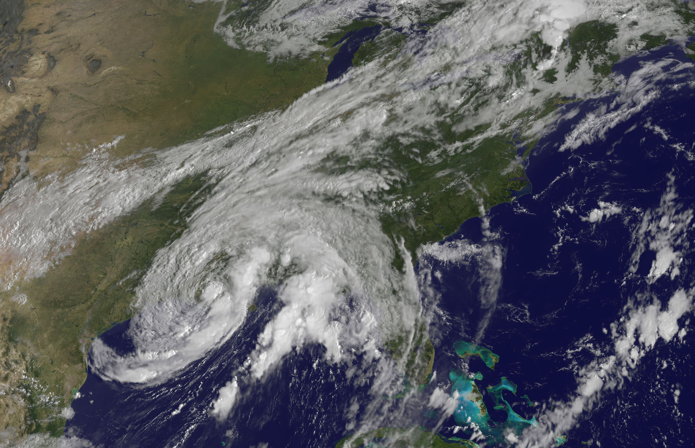
Tropical Storm Lee - Visible image from the GOES-13 satellite on Sunday, Sept. 4 at 9:32 a.m. EDT. It shows the extent of Lee's cloud cover over Louisiana, Mississippi, Alabama and the Florida Panhandle and spread into the Tennessee Valley. The thickest clouds and heaviest rainfall stretch from the northeast to southwest of the center. Credit: NASA/NOAA GOES Project
[/caption]
New imagery from NASA and NOAA satellites taken today (Sept 4) shows the extent of a hurricane season storm currently ravaging the US Gulf Coast and another potentially posing a new threat to US East Coast areas still suffering from the vast destruction caused by Hurricane Irene just days ago. Data from the NASA and NOAA satellites is critical in providing advance warning to government officials and local communities to save human lives and minimize property damage. .
Slow moving Tropical Storm Lee has unleashed strong thunderstorms and heavy rainfall in several Gulf Coast states. Rainfall amounts of up to 7 to 14 inches over the last 48 hours are currently drenching coastal and inland communities – especially in Louisiana, Mississippi and Alabama along a wide swath that extends from Texas to the Florida panhandle.
Isolated pockets of Gulf State areas may see up to 20 inches of rainfall. Severe flooding to homes and roads has occurred in some locations. Winds have diminished from 60 mph on Saturday (Sept. 3) to 45 mph on Sunday.
Imagery and measurements from the Aqua and GOES-13 satellites from NASA and NOAA revealed that TS Lee finally made landfall in Louisiana after two days of drenching rain along the Gulf Coast..
A tropical storm warning is in effect on Sept 4 for New Orleans, Lake Pontchartrain, and Lake Maurepas. Fortunately the rebuilt levees in New Orleans appear to holding in the first serious test since the vast destruction of Hurricane Katrina. Other areas are less lucky.
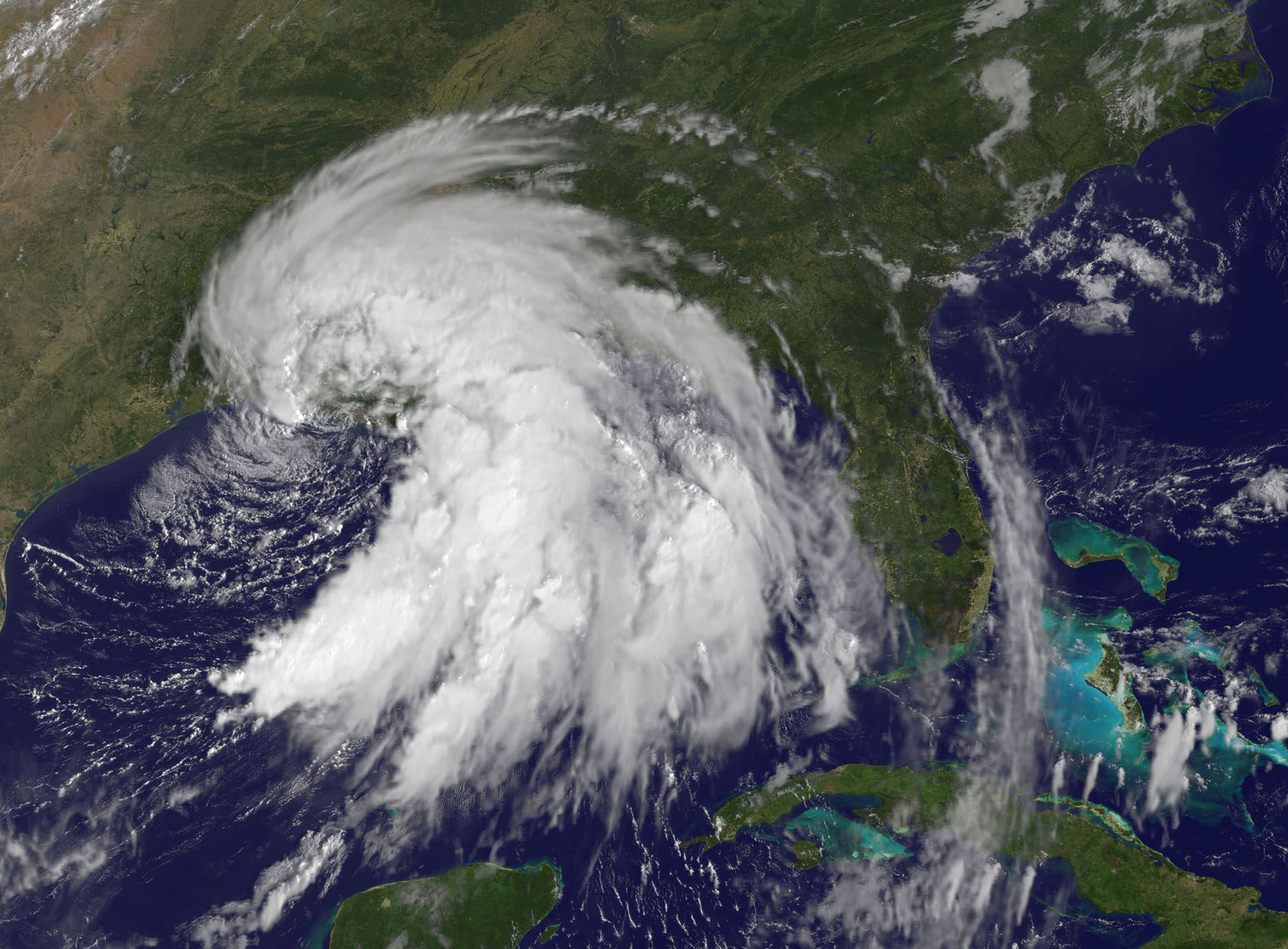
This infrared image of Tropical Storm Lee on Sept. 3 at 3:47 p.m. EDT when the center was still sitting south of the Louisiana coast. The strongest thunderstorms and coldest clouds (purple) stretched from Mobile Bay, south into the Gulf of Mexico and covered about 1/3rd of the Gulf of Mexico. Winds were 55 mph at the time of this image. The image was taken by the AIRS instrument on NASA's Aqua satellite. Credit: NASA JPL, Ed Olsen NASA
Lee’s tropical force winds now extend out 275 miles from the center. A large part of Lee is still over the Gulf of Mexico where the driving wind and rain affected operations on some oil rigs.
Lee has spawned more than a dozen tornadoes in the Gulf Coast states. The storm is spreading more heavy rain and winds on a northeast to east- northeast heading tracking towards Tennessee over the next 24 to 36 hours according to the latest weather forecasts.
Meanwhile Hurricane Katia is packing winds of 110 MPH and is on a path that could cause it to make landfall on the Outer Banks of North Carolina just a week after the state suffered from Hurricane Irene.
This GOES-13 satellite image shows Hurricane Katia (right), Tropical Depression 13 (left) and System 94L (top). Credit: NASA/NOAA GOES Project
Irene caused extensive flooding and devastation on the hundred year scale in several US states still reeling from flooding and destruction. More than 43 deaths have been reported so far, including emergency rescue workers. Initial damage estimates are over $6 Billion.
Thousands of East Coast homes and businesses are still without power as strong after effects from Irene continue to play out.
President Obama toured flood stricken areas of Paterson, New Jersey today (Sept. 4).
According to a statement by Rob Gutro, of NASA’s Goddard Space Flight Center, Greenbelt, Md; Tropical Storm Lee’s winds had dropped from 60 mph exactly 24 hours before to 45 mph at 8 a.m. EDT on Sept. 4.
Lee’s center was over Vermillion Bay, Louisiana near 29.7 North and 92.0 West. It was crawling to the northeast near 3 mph (6 kmh) and expected to continue in that direction today, turning to the east-northeast tonight. Because Lee’s center is over land, he is expected to continue weakening gradually in the next couple of days. Lee’s outer bands still extend far over the Gulf of Mexico, bringing in more moisture and keeping the system going.
Here's a 3-D look at Tropical Depression 13 from NASA's TRMM Satellite on Sept 1. Some of the highest thunderstorm towers in that area were shown by PR data to reach heights of over 15km (~9.3 miles) and there were areas of heavy rain - which is going to affect the shoreline.. waves of rainfall to move inland. Credit: NASA/GoddardThis visible image of Tropical Storm Lee was taken from the GOES-13 satellite on Saturday, Sept. 3 at 9:32 a.m. EDT. It shows the extent of Lee's cloud cover over Louisiana, Mississippi, Alabama and the Florida Panhandle. The clearing on the southeastern side is a result of drier air moving in and preventing development of thunderstorms. Credit: NASA/NOAA GOES Project
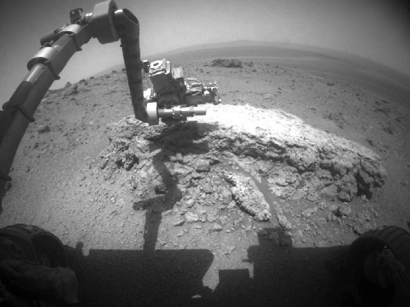
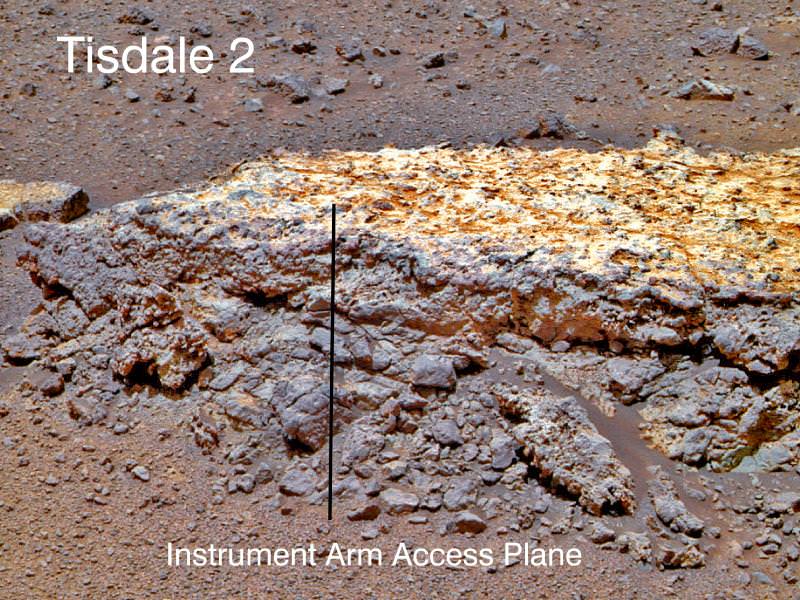
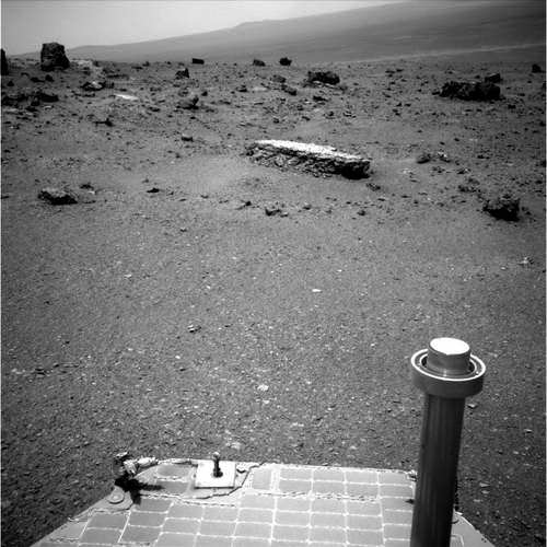
Opportunity investigates Tisdale 2 rock showing indications of ancient Martian water flow. NASA's Mars Exploration Rover Opportunity used its front hazard-avoidance camera to take this picture showing the rover's arm extended toward a light-toned rock, "Tisdale 2," during Sol 2695 of the rover's work on Mars (Aug. 23, 2011). The composition of Tisdale 2 is unlike any rock studied by Opportunity since landing 7.5 years ago. It is about 12 inches (30 centimeters) tall. Credit: NASA/JPL-Caltech
Scientists directing NASA’s Mars Opportunity rover gushed with excitement as they announced that the aging robot has discovered a rock with a composition unlike anything previously explored on the Red Planet’s surface – since she landed on the exotic Martian plains 7.5 years ago – and which offers indications that liquid water might have percolated or flowed at this spot billions of years ago.
Barely three weeks ago Opportunity arrived at the rim of the gigantic 14 mile ( 22 km) wide crater named Endeavour after an epic multi-year trek, and for the team it’s literally been like a 2nd landing on Mars – and the equivalent of the birth of a whole new mission of exploration at an entirely ‘new’ landing site.
“This is like having a brand new landing site for our veteran rover,” said Dave Lavery, program executive for NASA’s Mars Exploration Rovers at NASA Headquarters in Washington. “It is a remarkable bonus that comes from being able to rove on Mars with well-built hardware that lasts.”
Opportunity has traversed an incredible distance of 20.8 miles (33.5 km) across the Meridiani Planum region of Mars since landing on January 24, 2004 for a 3 month mission – now 30 times longer than the original warranty.
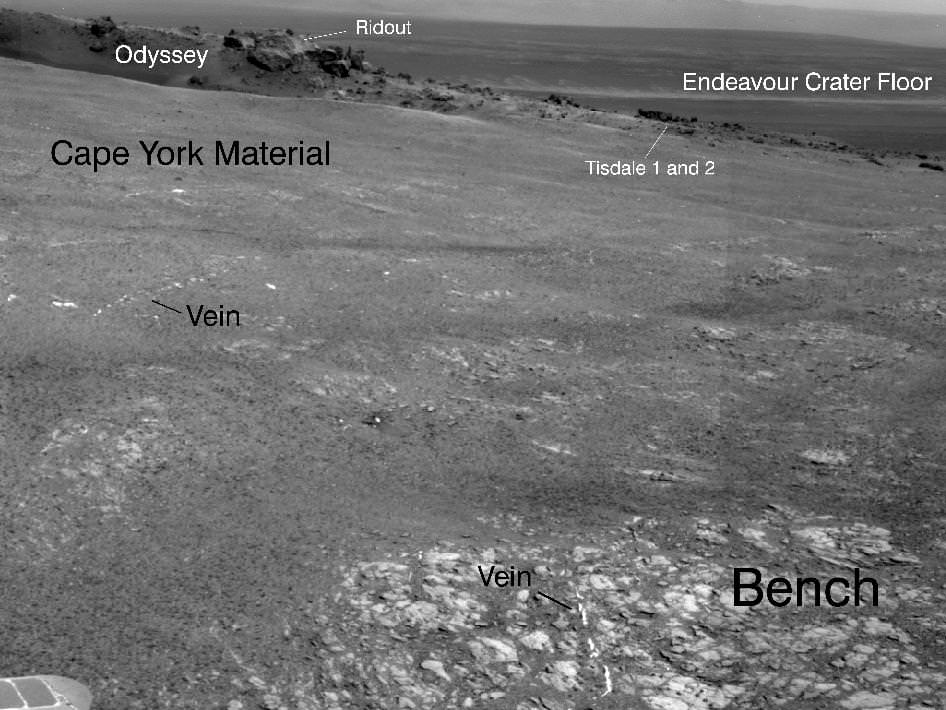
“Tisdale 2” is the name of the first rock that Opportunity drove to and investigated after reaching Endeavour crater and climbing up the rim at a low ridge dubbed ‘Cape York’.
This rock, informally named "Tisdale 2," was the first rock the NASA's Mars Rover Opportunity examined in detail on the rim of Endeavour crater. It has textures and composition unlike any rock the rover examined during its first 90 months on Mars. Its characteristics are consistent with the rock being a breccia -- a type of rock fusing together broken fragments of older rocks. Image credit: NASA/JPL-Caltech/Cornell/ASU
Endeavour’s rim is heavily eroded and discontinuous and divided into a series of segmented and beautiful mountainous ridges that offer a bonanza for science.
“This is not like anything we’ve ever seen before. So this is a new kind of rock.” said Steve Squyres, principal investigator for Opportunity at Cornell University in Ithaca, N.Y at a briefing for reporters on Sept. 1.
“It has a composition similar to some volcanic rocks, but there’s much more zinc and bromine than we’ve typically seen. We are getting confirmation that reaching Endeavour really has given us the equivalent of a second landing site for Opportunity.”
Tisdale 2 is a flat-topped rock about the size of a footstool that was blasted free by the impact that formed the tennis court sized “Odyssey” crater from which it was ejected.
“The other big take-away message, and this is to me the most interesting thing about Tisdale, is that this rock has a huge amount of zinc in it, way more zinc than we have ever seen in any Martian rock. And we are puzzling, we are thinking very hard over what that means,” Squyres speculated.
Bright veins cutting across outcrop in a section of Endeavour crater's rim called "Botany Bay" are visible in the foreground and middle distance of this view assembled from images taken by the navigation camera on Opportunity during Sol 2,681on Mars (Aug. 9, 2011). Credit: NASA/JPL-Caltech
Squyres said that high levels of zinc and bromine on Earth are often associated with rocks in contact with flowing water and thus experiencing hydrothermal activity and that the impact is the source of the water.
“When you find rocks on Earth that are rich in zinc, they typically form in a place where you had some kind of hydrothermal activity going on, in other words, you have water that gets heated up and it flows through the rocks and it can dissolve out and it can get redeposited in various places,” Squyres explained.
“So this is a clue, not definitive proof yet, but this is a clue that we may be dealing with a hydrothermal system here, we may be dealing with a situation where water has percolated or flowed or somehow moved through these rocks, maybe as vapor, maybe as liquid, don’t know yet.”
“But it has enhanced the zinc concentration in this rock to levels far in excess of anything we’ve ever seen on Mars before. So that’s the beginning of what we expect is going to be a long and very interesting story about these rocks.”
Endeavour crater was chosen three years ago as the long term destination for Opportunity because it may hold clues to a time billions and billions of years ago when Mars was warmer and wetter and harbored an environment that was far more conducive to the formation of life beyond Earth.
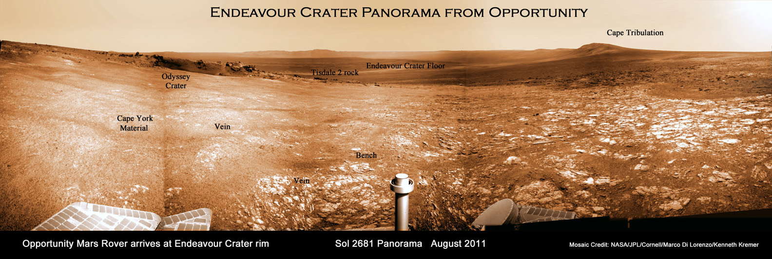
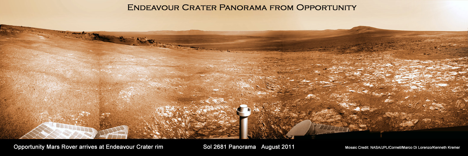
Endeavour Crater Panorama from Opportunity, Sol 2681, August 2011
Opportunity arrived at the rim of Endeavour on Sol 2681, August 9, 2011 and climbed up the ridge known as Cape York. Odyssey crater is visible at left. The rover has driven to Tisdale 2 rock at the outskirts of Odyssey to investigate the ejecta blocks which may hold clues to ancient water flow on Mars. Distant portions of Endeavour’s rim - as far as 13 miles away – visible in the background. The rover will likely drive eventually to the Cape Tribulation rim segment at right which holds a mother lode of clay minerals. This photo mosaic was stitched together from raw images taken by Opportunity on Sol 2681.
Mosaic Credit: NASA/JPL/Cornell/Marco Di Lorenzo/Kenneth Kremer
Signatures of clay minerals, or phyllosilicates, were detected at several spots at Endeavour’s western rim by observations from the Compact Reconnaissance Imaging Spectrometer for Mars (CRISM) aboard NASA’s Mars Reconnaissance Orbiter (MRO).
“The motherlode of clay minerals is on Cape Tribulation. The exposure extends all the way to the top, mainly on the inboard side,” said Ray Arvidson, the rover’s deputy principal investigator at Washington University in St. Louis.
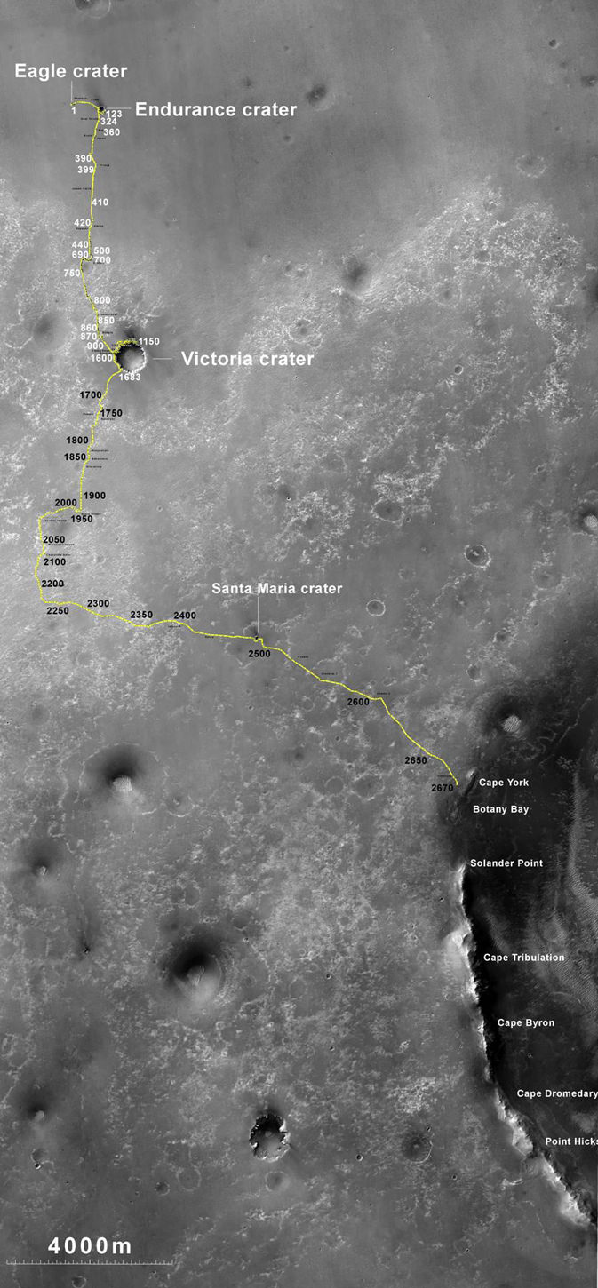
Opportunity Traverse Map: 2004 to 2011. The yellow line on this map shows where NASA's Mars Rover Opportunity has driven from the place where it landed in January 2004 -- inside Eagle crater, at the upper left end of the track -- to a point approaching the rim of Endeavour crater. The map traces the route through the 2,670th Martian day, or sol, of Opportunity's work on Mars (July 29, 2011). Image credit: NASA/JPL-Caltech/MSSS/NMMNHS.
Phyllosilicates are clay minerals that form in the presence of pH neutral water and which are far more hospitable to the possible genesis of life compared to the sulfate rich rocks studied in the more highly acidic aqueous environments examined by both the Opportunity and Spirit rovers thus far.
“We can get up the side of Cape Tribulation,” said Arvidson. It’s not unlike Husband Hill for Spirit. We need to finish up first at Cape York, get through the martian winter and then start working our way south along Solander Point.
The general plan is that Opportunity will probably spend the next several months exploring the Cape York region for before going elsewhere. “Just from Tisdale 2 we know that we have something really new and different here,” said Squyres.
“On the final traverses to Cape York, we saw ragged outcrops at Botany Bay unlike anything Opportunity has seen so far, and a bench around the edge of Cape York looks like sedimentary rock that’s been cut and filled with veins of material possibly delivered by water,” said Arvidson. “We made an explicit decision to examine ancient rocks of Cape York first.”
So far at least the terrain at Cape York looks safe for driving with good prospects for mobility.
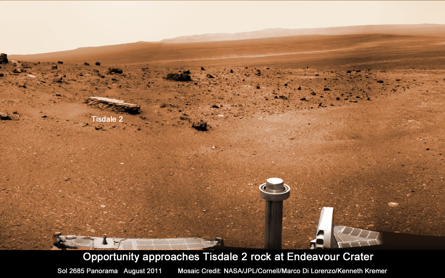
Opportunity approaches Tisdale 2 rock at Endeavour Crater rim
Opportunity Mars rover climbed up the ridge known as Cape York and drove to the flat topped Tisdale 2 rock at upper left to analyze it with the science instruments on the robotic arm. This photo mosaic was stitched together from raw images taken by Opportunity on Sol 2685, August 2011.
Mosaic Credit: NASA/JPL/Cornell/Marco Di Lorenzo/Kenneth Kremer
“The good news is that, as predicted, we have hard packed soils like the plains at Gusev that Spirit saw before getting to the Columbia Hills,” said Arvidson. “The wheel tracks at Cape York are very, very shallow. So if anything we will have some skid going downhill the slopes of 5 to 10 degrees on the inboard side which we can correct for.”
“We are always on the lookout for sand traps. We are particularly sensitized to that after the Spirit situation. So far it’s clear sailing ahead.”
Opportunity will then likely head southwards towards an area dubbed “Botany Bay” and eventually drive some 1.5 km further to the next ridge named Cape Tribulation and hopefully scale the slopes in an uphill search for that mother lode of phyllosilicates.
“My strong hope – if the rover lasts that long – is that we will have a vehicle that is capable of climbing Cape Tribulation just as we climbed Husband Hill with Spirit. So it’s obvious to try if the rover is capable, otherwise we would try something simpler. But even if we lose a wheel we still have a vehicle capable of a lot of science,” Squyres emphasized. “Then we would stick to lower ground and more gently sloping stuff.”
“The clear intention as we finish up at Cape York, and look at what to do next, is that we are going to work our way south. We will focus along the crater’s rim. We will work south along the rim of Endeavour unless some discovery unexpectedly causes us to do something else.”
“We will go where the science takes us !” Squyres stated.
Opportunity is in generally good health but the rover is showing signs of aging.
“All in all, we have a very senior rover that’s showing her age, she has some arthritis and some other issues but generally, she’s in good health, she’s sleeping well at night, her cholesterol levels are excellent and so we look forward to productive scientific exploration for the period ahead,” said John Callas, project manager for Opportunity at NASA’s Jet Propulsion Laboratory in Pasadena, Calif.
“This has the potential to be the most revealing destination ever explored by Opportunity,” said Lavery. “This region is substantially different than anything we’ve seen before. We’re looking at this next phase of Opportunity’s exploration as a whole new mission, entering an area that is significantly different in the geologic context than anything we’ve seen with the rovers.”
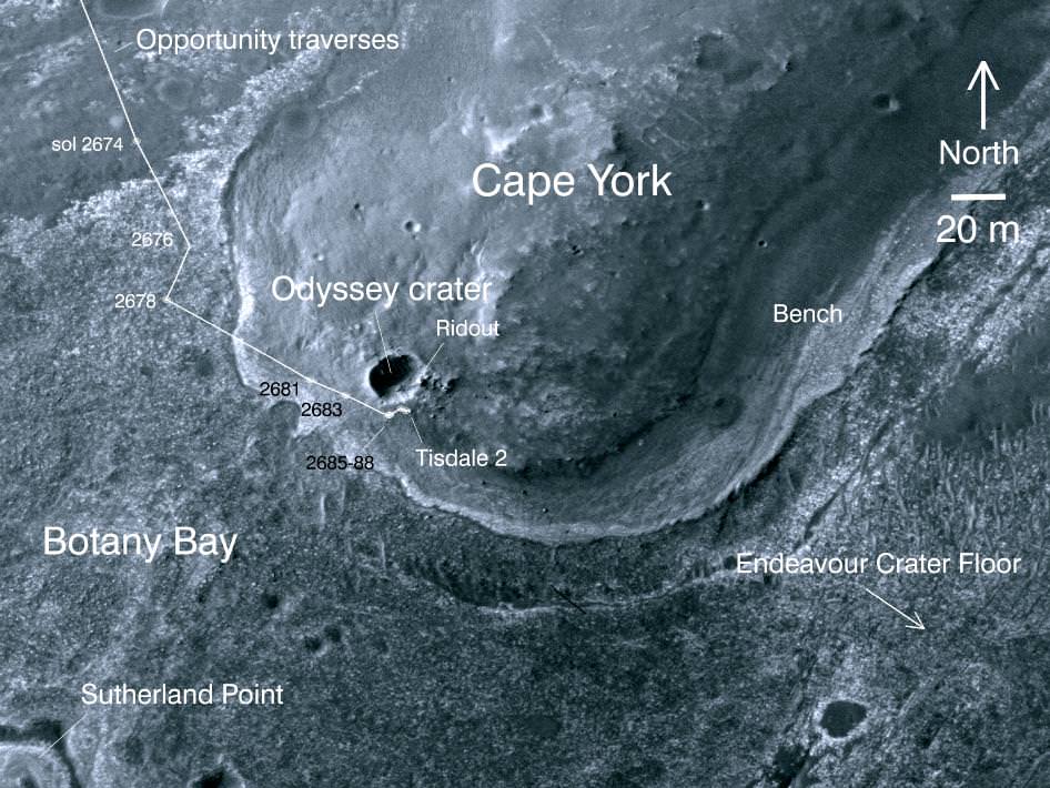
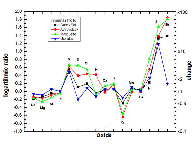
This image taken from orbit shows the path of the path driven by NASA's Mars Exploration Rover Opportunity in the weeks around the rover's arrival at the rim of Endeavour crater. The sol number (number of Martian days since the rover landed on Mars) are indicated along the route. Sol 2674 corresponds to Aug. 2, 2011; Sol 2688 corresponds to Aug. 16, 2011. Image credit: NASA/JPL-Caltech/University of ArizonaElevated Zinc and Bromine in Tisdale 2 Rock on Endeavour Rim. This graphic presents information gained by examining part of the Martian rock called "Tisdale 2" with the alpha particle X-ray spectrometer on Mars rover Opportunity and comparing the composition measured there with compositions of other targets examined by Opportunity and its rover twin, Spirit. The comparison targets are soil in Gusev crater, examined by Spirit; the relatively fresh basaltic rock Adirondack, examined by Spirit; the stony meteorite Marquette examined by Opportunity; and Gibraltar, an example of sulfate-rich bedrock examined by Opportunity. The target area on Tisdale 2, called "Timmins 1," contains elevated levels of bromine (Br), zinc (Zn), phosphorus (P), sulfur (S) and chlorine (Cl) relative to the non-sulfate-rich comparison rocks, and high levels of zinc and phosphorus relative to Gibraltar. Credit: NASA/JPL-Caltech/Cornell/Max Planck Institute/University of Guelph
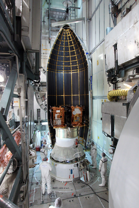
Twin GRAIL Lunar Mappers being enclosed with payload fairing atop Delta II rocket. Spacecraft technicians monitor the movement of a section of the clamshell-shaped Delta payload fairing as it encloses NASA's twin Gravity Recovery and Interior Laboratory spacecraft at Space Launch Complex 17B on Cape Canaveral Air Force Station in Florida. Liftoff is slated for Sept. 8 at 8:37 a.m. EDT. Credit: NASA/Jim Grossmann
[/caption]
NASA’s powerful lunar mapping duo of GRAIL spacecraft are now poised for liftoff in just one weeks time on Thursday, Sept. 8.
Mission managers held a Flight Readiness Review on Wednesday (Aug.31) and gave a tentative approval to begin fueling the Delta II rockets second stage on Sept. 2 and 3 after evaluating all issues related to the rocket, launch pad and payloads.
Launch preparations are proceeding on schedule towards an early morning lift off from the seaside Space Launch Complex 17B (SLC-17B) at Cape Canaveral Air Force Station, Florida. There are two instantaneous launch windows at 8:37:06 a.m. and 9:16:12 a.m. EDT lasting one second each.
“Launch vehicle and spacecraft closeouts will begin on Tuesday, and the Launch Readiness Review is also scheduled for Tuesday morning,” NASA KSC spokesman George Diller told Universe Today.
“This morning’s launch countdown dress rehearsal went fine.”
“Delta II 2nd stage fueling has been rescheduled for Friday and Saturday [Sept. 2 and 3]. Last evening a software error was found in the launch processing system data base. ULA (United Launch Alliance) decided they would like to look for any additional errors before the fueling begins. There is no impact to the launch date and currently no work is scheduled on Sunday or on Labor Day,” said Diller.
The launch period extends through Oct. 19, with liftoff occurring approximately four minutes earlier each day in case of a delay. The flight plan was designed to avoid a pair of lunar eclipses occurring on December 10th, 2011 and June 4th 2012 which would interfere with the missions operations and science.
The team is keeping a close watch on the weather as the season’s next Atlantic Ocean storm heads westwards. Katia has just been upgraded to Hurricane status and follows closely on the heels of the continuing vast destruction, misery and deaths caused by Hurricane Irene earlier this week.
“The preliminary weather forecast is favorable for launch day as long as the wind remains out of the west as is currently forecast for that time of the morning,” Diller told me.
Twin GRAIL Lunar Mappers are secured atop Delta II rocket and await enclose in the Delta payload fairing. The fairing will protect the spacecraft from the impact of aerodynamic pressure and heating during ascent and will be jettisoned once the spacecraft is outside the Earth's atmosphere. Credit: NASA/Jim Grossmann
The twin probes known as GRAIL-A and GRAIL-B (Gravity Recovery and Interior Laboratory) were encapsulated inside the clamshell like payload fairing on Aug. 23 The nearly identical spacecraft are mounted side by side and sit atop the Centaur upper stage.
The fairing shields the spacecraft from aerodynamic pressures, friction and extreme heating for the first few minutes of flight during ascent through the Earth atmosphere.
This Delta II Heavy booster rocket is the most powerful version of the Delta II family built by ULA. The booster’s first stage is augmented with larger diameter solid rocket motors.
GRAIL was processed for launch inside at the Astrotech payload processing facility in Titusville, Fla. See my GRAIL spacecraft photos from inside the Astrotech clean room facilities here.
“The GRAIL spacecraft inside the handling can departed Astrotech and arrived at the launch pad, SLC-17B on Aug. 18” said Tim Dunn, NASA’s Delta II Launch Director in an interview with Universe Today. “The spacecraft was then hoisted by crane onto the Delta II launch vehicle and the spacecraft mate operation was flawlessly executed by the combined ULA and NASA Delta II Team.”
An Integrated Systems Test (IST) of the mated booster and payload was completed on Aug. 22
Technicians prepare twin GRAIL spacecraft for enclosure in the Delta payload fairing. Credit: NASA/Jim Grossmann
The dynamic duo will orbit the moon in a tandam formation just 50 kilometers above the lunar surface with an average separation of 200 km. During the 90 day science phase the goal is to determine the structure of the lunar interior from crust to core and to advance understanding of the thermal evolution of the moon.
GRAIL-A & GRAIL-B will measure the lunar gravity field with unprecedented resolution up to 100 times improvement on the near side and 1000 times improvement for the far side.
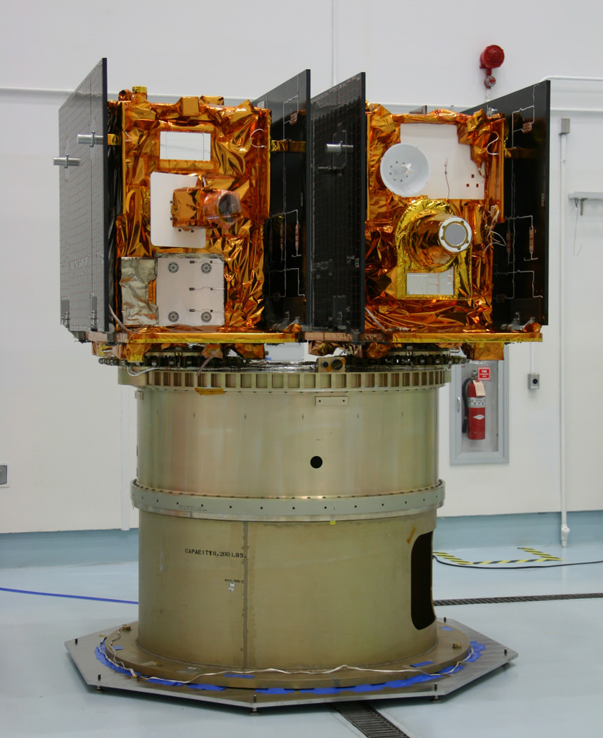
NASA’s twin GRAIL Science Probes ready for Lunar Expedition
GRAIL B (left) and GRAIL A (right) spacecraft are mounted side by side on top of a payload adapter inside the clean room at Astrotech Space Operations facility. The spacecraft await lunar launch on Sept. 8, 2011. Credit: Ken Kremer
Earth & Moon Portrait - First Photo transmitted from Jupiter Bound Juno. This image of Earth (on the left) and the moon (on the right) was taken by NASA's Juno spacecraft on Aug. 26, 2011, when the spacecraft was about 6 million miles (9.66 million kilometers) away. It was taken by the spacecraft's onboard camera, JunoCam. Credit: NASA/JPL-Caltech
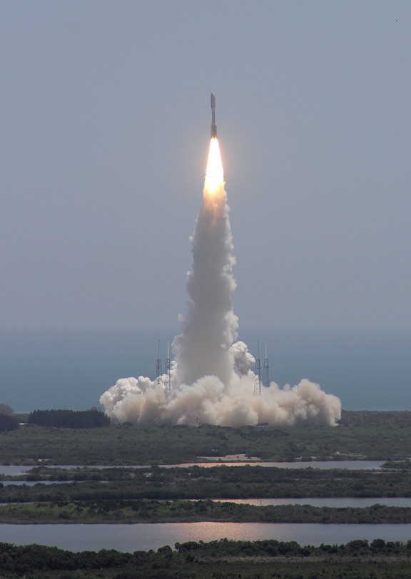
Juno lifted off 25 days ago at 12: 25 p.m. on August 5 from Space Launch Complex 41 at Cape Canaveral Air Force Station in Florida. The spacecraft snapped the portrait with the onboard JunoCam camera on August 26 after journeying some 6 million miles (9.66 million km) from Earth and while traveling at a velocity of 77,600 miles per hour (124,900 kilometers per hour) relative to the sun.
“The image of the Earth Moon system is a rather unique perspective that we can get only by stepping outside of our home planet,” said Scott Bolton, Juno principal investigator, in an exclusive interview with Universe Today. Bolton is from the Southwest Research Institute in San Antonio.
“On our way to Jupiter, we’ve looked back at home and managed to take this amazing image.”
“Earth looking much like any other planet or star from a distance is glorious as this somewhat average looking “star” is home to all of humanity. Our companion, the moon, so beautiful and important to us, stands out even less.”
“We appear almost average and inconspicuous, yet all of our history originates here. It makes one wonder just how many other planets or solar systems might contain life like ours,” Bolton told me.
Juno casts a shadow back toward Earth and Space Shuttle Launch Pad 39A and the shuttle crawler way (at left) seconds after liftoff from adjacent Launch Pad 41 at Cape Canaveral, Florida. View from the VAB Roof. Credit: Ken Kremer
The Juno team commanded the probe to take the image as part of the checkout phase of the vehicles instruments and subsystems.
“The JunoCam instrument turn on and check out were planned activities. The instrument is working great and in fact, all the instruments that we’ve turned on thus far have been working great,” Bolton added.
So far the spacecraft is in excellent health and the team has completed the checkout of the Waves instrument and its two Flux Gate Magnetometer sensors and deployment of its V-shaped electric dipole antenna.
“We have a couple more instruments still to do,” Bolton noted.
The team reports that Juno also performed its first precession, or reorientation maneuver, using its thrusters and that the first trajectory control maneuver (TCM-1) was cancelled as unnecessary because of the extremely accurate targeting provided by the Atlas V rocket.
The portrait shot is actually not Juno’s last photo of her home.
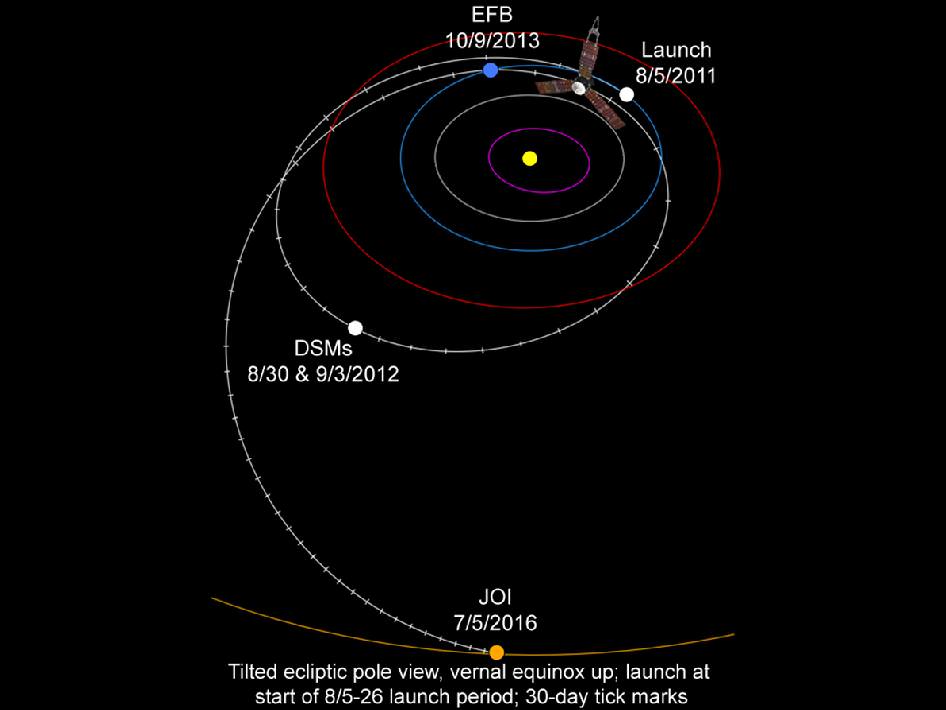
The 8000 pound (3,600 kilogram) probe will fly by Earth once more on October 9, 2013 for a gravity assisted speed boost of 16,330 MPH (7.3 km/sec) to accelerate Juno past the asteroid belt on its long journey to the Jovian system.
Juno soars skyward to Jupiter on Aug. 5 from launch pad 41 at Cape Canaveral Air Force Station at 12:25 p.m. EDT. View from the VAB roof. Credit: Ken Kremer
JunoCam will collect new photos and the other science instruments will make measurements as Juno cartwheels past Earth during the slingshot to Jupiter.
Juno is on a 5 year and 1.7 Billion mile (2.8 Billion km) trek to the largest planet in our solar system. When she arrives at Jupiter on July 4, 2016, Juno will become the first polar orbiting spacecraft at the gas giant.
During a one year science mission – entailing 33 orbits lasting 11 days each – the probe will plunge to within about 3000 miles (5000 km) of the turbulent cloud tops and collect unprecedented new data that will unveil the hidden inner secrets of Jupiter’s genesis and evolution.
The goal is to find out more about the planets origins, interior structure and atmosphere, observe the aurora, map the intense magnetic field and investigate the existence of a solid planetary core.
“This is a remarkable sight people get to see all too rarely,” said Bolton in a NASA statement about the Earth-Moon photo. “This view of our planet shows how Earth looks from the outside, illustrating a special perspective of our role and place in the universe. We see a humbling yet beautiful view of ourselves.”
NASA’s Jet Propulsion Laboratory manages the Juno mission. The spacecraft was designed and built by Lockheed Martin Space Systems, Denver.
Juno and Booster Streak Across the Stars
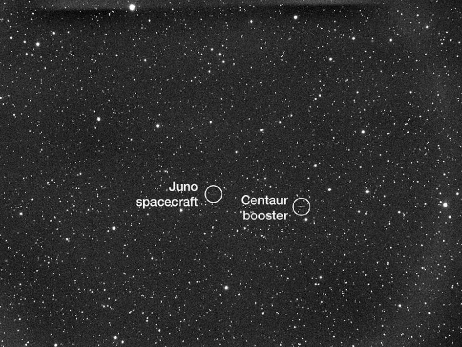
NASA's Juno spacecraft and its spent Centaur upper rocket stage are captured in this telescope view as they move across the field of stars. The five-minute, timed exposure was acquired on Aug. 5 11:18pm Eastern time (Aug. 6 at 3:18 UTC) when Juno was at a distance of about 195,000 miles (314,000 kilometers) from Earth. The images were taken remotely by amateur astronomer Scott Ferguson using Global Rent-a-Scope's GRAS-016 Takahashi Widefield Refractor, which is located in Nerpio, Spain. Credit: Scott FergusonJuno Spacecraft Cruise Trajectory to Jupiter
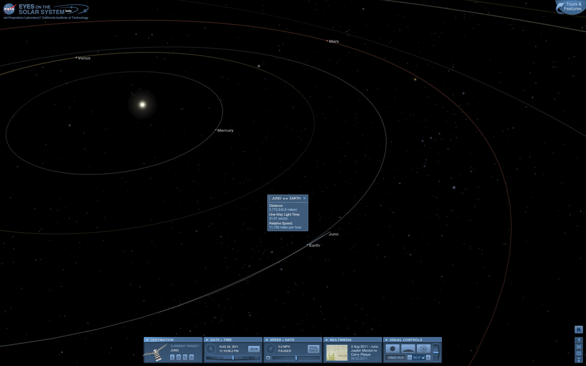
This graphic shows Juno's trajectory, or flight path, from Earth to Jupiter. The spacecraft travels around the Sun, to a point beyond the orbit of Mars where it fires its main engine a couple of times. These deep space maneuvers set up the Earth flyby maneuver that occurs approximately two years after launch. The Earth flyby gives Juno the boost in velocity it needs to coast all the way to Jupiter. Juno arrives at Jupiter in July 2016. Credit: NASA/JPL-CaltechView of Juno’s position on Aug. 24, 2011 nearly 6 million miles distant from Earth visualized by NASA’s Eyes on the Solar System website.
Irene Makes Landfall Over New York. This GOES-13 satellite image is of Hurricane Irene just 28 minutes before the storm made landfall in New York City. The image shows Irene's huge cloud cover blanketing New England, New York and over Toronto, Canada. Shadows in Irene's clouds indicate the bands of thunderstorms that surrounded the storm. Credit: NASA/NOAA GOES Project
NASA Video Caption: The Life of Hurricane Irene from the Caribbean to Canada from August 21 through August 29 seen by NASA/NOAA satellites. Credit: NASA/NOAA/GOES/MODIS
The new NASA animation above shows the birth and subsequent destructive and deadly path followed by Hurricane Irene from August 21 through August 29, 2011 starting in the Caribbean, and then tracking along the US East Cost and up into Canada. The observations combine images taken by NASA and NOAA Earth orbiting satellites.
The cloud images were captured by the NASA/NOAA GOES-13 satellite and overlaid on a true-color NASA MODIS map. Irene followed a lengthy course over Puerto Rico, Hispaniola, the Bahamas, and then along the entire US East with landfalls over North Carolina, New Jersey and New York.
NASA ISS astronaut Ron Garan and cameras flying overhead aboard the International Space Station (ISS) also photographed vivid images showing the magnitude of Irene slamming into the US East coast.
Irene caused widespread property damage. Massive and raging flooding in several US states destroyed houses, crushed businesses and washed away bridges and roads and more. The worst flooding is yet to come to some inland portions of Vermont, New Jersey, New York, Pennsylvania and elsewhere as uncontrollable waters continue to rise at numerous rivers, lakes and even ponds, threatening even more misery in their wake.
[/caption]
So far 41 fatalities in 12 states have been attributed to Irene and more may be expected as searches continue. Some communities have been entirely cut off due to washed out access. Airlifts of food and water have begun. More people are being evacuated from New Jersey towns today, Aug 30.
Brave emergency rescue workers have put their own lives at peril and saved the lives of countless others of all ages from babies to the elderly. Some 8 million customers, including my area, lost power due to extensive flooding, downed trees and electrical wires, and devastated infrastructure.
Hurricane Irene twitpic from the International Space Station on 8/27/11 by NASA Astronaut Ron Garan
Irene From Space and the ISS as it crossed the coast on August 27, 2011 at 3:32pm EST. Hope everyone is OK wrote NASA Astronaut Ron Garan with his twitpic from the ISS. Credit: NASA/Ron Garan aboard the ISS
Emergency crews are hard at work to restore power as quickly as possible, but many thousands of homes and businesses could be without power for up to a week or more. About 3.3 million customers are still without power today.
NASA’s GOES-13 satellite captured a dramatic view of Hurricane Irene just 28 minutes prior to making landfall over New York City. Today’s NASA Image of the day shows the humongous cloud cover spanning the US East coast from the Mid-Atlantic States up to New Jersey, New York, Pennsylvania, and New England and into Toronto, Canada.
This GOES-13 image from Monday, August 29 at 7:45 a.m. EDT shows an active Atlantic Ocean with the remnants of Hurricane Irene moving into Quebec and Newfoundland (left), Tropical Storm Jose (center) and newly formed Tropical Depression 12 (right). Credit: NASA/NOAA GOES ProjectIrene slams into North Carolina. The GOES-13 satellite saw Hurricane Irene on August 27, 2011 at 10:10 a.m. EDT after it made landfall at 8 a.m. in Cape Lookout, North Carolina. Irene's outer bands had already extended into New England. Credit: NASA/NOAA GOES Project
Many transit systems and airports in Irene’s path were shutdown ahead of the storm.
Send me your photos of Irene’s destruction to post at Universe Today.
Endeavour Crater Panorama from Opportunity, Sol 2681, August 2011. NASA’s Opportunity Mars rover arrived at the rim of huge Endeavour crater on Sol 2681, August 9, 2011 and climbed up the ridge known as Cape York. A small crater dubbed ‘Odyssey’ is visible in the foreground at left. The rover has now driven to the outskirts of Odyssey to investigate the ejecta blocks which may stem from an ancient and wetter Martian Epoch. Opportunity snapped this soaring panorama showing distant portions of Endeavour’s rim - as far as 13 miles away - in the background. This photo mosaic was stitched together from raw images taken by Opportunity on Sol 2681. Mosaic Credit: NASA/JPL/Cornell/Marco Di Lorenzo/Kenneth Kremer
[/caption]NASA’s Mars Opportunity rover has finally arrived at the huge Martian crater named Endeavour that simultaneously offers a mother lode of superb scenery and potentially the “Mother of all Martian Science”. The epic journey took nearly three years.
The intrepid robogirl is now climbing uphill on a Scientific quest that may well produce bountiful results towards the most important findings ever related to the search for life on Mars. Opportunity arrived at the western rim of the 13 mile (21 km) wide Endeavour crater on the 2681st Sol , or Martian day, of a mission only warrantied to last 90 Sols.
See our new Opportunity panoramic mosaics (Marco Di Lorenzo & Ken Kremer) illustrating the magnificent scenery and science targets now at hand on the surface of the Red Planet, thanks to the diligent work of the science and engineering teams who created the twin Mars Exploration Rover (MER) vehicles – Spirit & Opportunity.
Opportunity made landfall at Endeavour at a ridge of the discontinuous crater rim named Cape York and at a spot dubbed “Spirit Point” – in honor or her twin sister Spirit which stopped communicating with Earth about a year ago following more than six years of active science duty. See traverse map mosaic.
The martian robot quickly started driving northwards up the gnetle slopes of Cape York and has reached a small crater named “Odyssey” – the first science target, Dr. Matt Golembek told Universe Today. Golembek is a Senior Research Scientist with the Mars Exploration Program at the Jet Propulsion Laboratory (JPL) in Pasadena, Calif.
“Large ejecta blocks are clearly visible on the rim of Odyssey crater,” said Golembek. The crater is about 66 feet (20 m) in diameter.
Odyssey is a small impact crater of interest to the team because it features exposed material from Mars ancient Noachian era that was ejected when the crater was excavated long ago. Opportunity carefully drove over several days to one of those ejecta blocks – a flat topped rock nicknamed Tisdale 2.
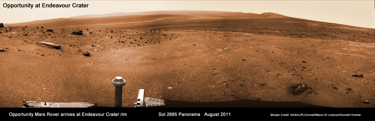
Endeavour Crater Panorama from Opportunity, Sol 2685, August 2011
NASA’s Opportunity Mars rover arrived at the rim of huge Endeavour crater on Sol 2681, August 9, 2011 and is climbed up the ridge known as Cape York. She drove to the flat topped Tisdale 2 rock at upper left to analyze it with the science instruments on the robotic arm. Opportunity snapped this soaring panorama showing distant portions of Endeavour’s rim - as far as 13 miles away - in the background. This photo mosaic was stitched together from raw images taken by Opportunity on Sol 2685.
Mosaic Credit: NASA/JPL/Cornell/Marco Di Lorenzo/Kenneth Kremer
“Opportunity is at a block of Odyssey crater ejecta called Tisdale 2 and the rock appears different from anything else we have seen,” Golembek explained.
Starting on Sol 2688 (Aug. 16) the rover began a science campaign time to investigate the rock with the instruments at the terminus of its robotic arm or IDD (Instrument Deployment Device) that will continue for some period of time.
“We are about to start an IDD campaign,” Golembek stated.
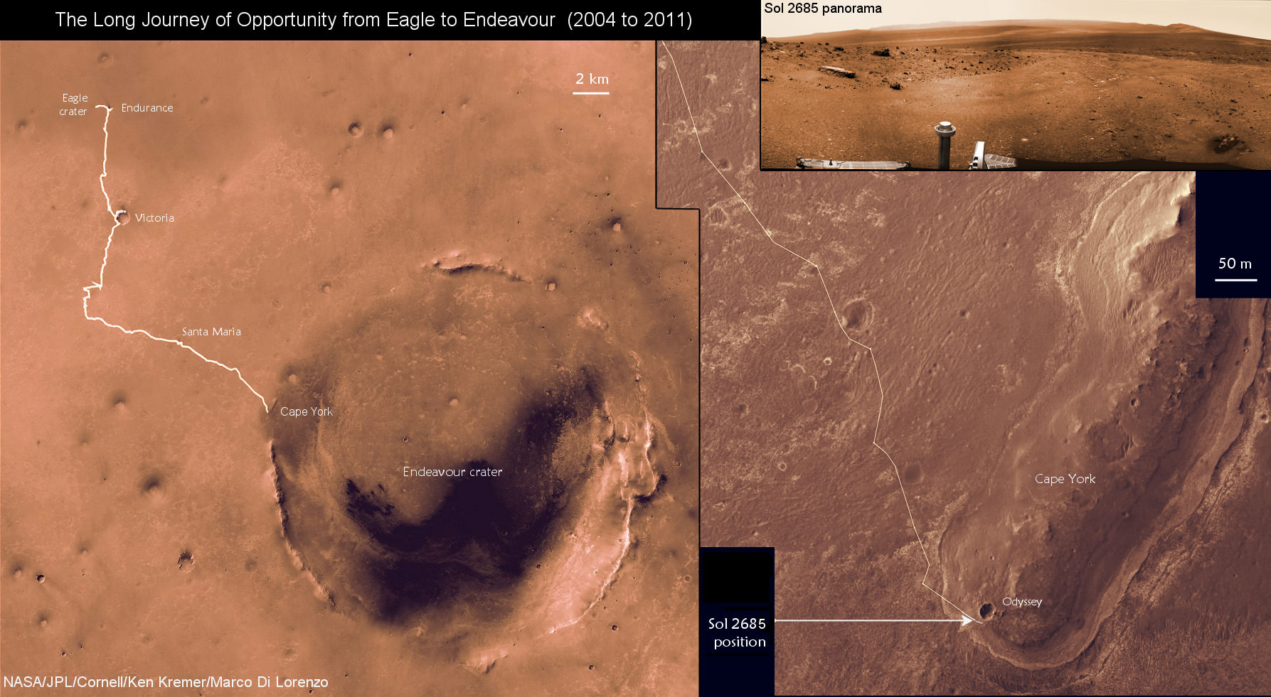
The Long Journey of Opportunity form Eagle to Endeavour Crater (2004 to 2011).
This map mosaic shows Opportunity’s epic trek of nearly eight years from landing at Eagle crater on January 24, 2004 to arrival at the giant 13 mile (21 km) diameter Endeavour crater in August 2011. Opportunity arrived the Endeavour’s rim and then drove up a ridge named Cape York. The photomosaic at top right show the outlook from Cape York on Sol 2685 (August 2011).
Mosaic Credit: NASA/JPL/Cornell/Kenneth Kremer/Marco Di Lorenzo
The team reports that the soil at Cape York is also of a different texture than any that Opportunity has seen so far on her incredible 20 mile (33 km) trek across the Meridiani Planum region of Mars. So far they haven’t seen of the iron-rich concretions, nicknamed “blueberries,” which have been plentiful on the surface along the way at numerous locations Opportunity has stopped at and investigated over the past 90 months. Initially the prime mission was projected to last 3 months – the remainder has been a huge bonus.
The science team is directing Opportunity to hunt for clay minerals, also known as phyllosilicates, that could unlock the secrets of an ancient Epoch on Mars stretching back billions and billions of years ago that was far wetter and very likely more habitable and welcoming to life’s genesis.
Phyllosilicate minerals form in neutral water that would be vastly more friendly to any potential Martian life forms – if they ever existed in the past or present. Signatures for phyllosilicates were detected by the CRISM instrument aboard NASA’s powerful Mars Reconnaissance Orbiter (MRO) spacecraft circling Mars
Flat-topped Tisdale 2 rock. Credit: NASA/JPL-Caltech'Ridout' Rock on Rim of Odyssey Crater. Opportunity looked across small Odyssey crater on the rim of much larger Endeavour crater to capture this raw image from its panoramic camera during the rover's 2,685th Martian day, or sol, of work on Mars (Aug. 13, 2011). From a position south of Odyssey, this view is dominated by a rock informally named "Ridout" on the northeastern rim of Odyssey. The rock is roughly the same size as the rover, which is 4.9 feet (1.5 meters) long. Credit: NASA/JPL-Caltech/Cornell/ASU
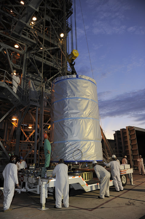
GRAIL Lunar Twins hoisted to top of Launch Pad 17B at Cape Canaveral. NASA's twin Gravity Recovery and Interior Laboratory (GRAIL) spacecraft are lifted to the top of their launch pad at Space Launch Complex 17B at Cape Canaveral Air Force Station in Florida and were mated to their Delta II Heavy Booster Rocket. They are wrapped in plastic to prevent contamination outside the clean room. Launch is scheduled for Sept. 8. Credit: NASA/Kim Shiflett
[/caption]
With blastoff just 2 ½ weeks away, NASA’s GRAIL lunar twins completed a major milestone towards launch today (Aug. 18) when they were mated to the top of the Delta II Heavy rocket that will boost them to the moon. Launch is slated for Sept. 8 at 8:37 a.m. EDT.
This morning the tightly wrapped $496 Million duo took their last trip on Earth before beginning their nearly four month journey to the Moon. GRAIL A & GRAIL B were carefully transported 15 miles (25 km) from the clean room processing facility at the Astrotech Space Operation’s payload processing facility in Titusville, Fla to Space Launch Complex 17B (SLC-17B) at Cape Canaveral Air Force Station in Florida.
“The GRAIL spacecraft transportation convoy to SLC-17B departed Astrotech at 11:55 p.m. EDT on Wednesday, Aug. 17, “ said Tim Dunn, NASA’s Delta II Launch Director in an interview with Universe Today. “The spacecraft, inside the handling can, arrived at the launch pad, SLC-17B, at 4:00 a.m. this morning.”
“The spacecraft was then hoisted by the Mobile Service Tower crane onto the Delta II launch vehicle and the spacecraft mate was complete at 9:30 a.m.”
Crane lifts GRAIL A & B to the top of the Mobile Service Tower on Aug. 18. The probes are wrapped in protective plastic sheeting inside the handling can. Credit: NASA/Kim Shiflett
Technicians joined the nearly identical and side by side mounted spacecraft onto the top of the guidance section adapter of the Delta’s second stage. The Delta II was built by United Launch Alliance (ULA).
“Tomorrow, the GRAIL spacecraft team will perform functional testing on both the GRAIL A and GRAIL B spacecraft,” Dunn told me.
“The next major milestone will be performance of the Integrated Systems Test (IST) on Monday, (8/22/11).
“Today’s spacecraft mate operation was flawlessly executed by the combined ULA and NASA Delta II Team,” said Dunn.
These tests will confirm that the spacecraft is healthy after the fueling and transport operations. After further reviews of the rocket and spacecraft systems the GRAIL team will install the payload fairing around the lunar probes.
NASA’s twin GRAIL Science Probes ready for Lunar Expedition
GRAIL B (left) and GRAIL A (right) spacecraft are mounted side by side on top of a payload adapter inside the clean room at Astrotech Space Operations facility. The spacecraft await lunar launch on Sept. 8, 2011. Credit: Ken Kremer
NASA’s dynamic duo will orbit the moon to determine the structure of the lunar interior from crust to core and to advance understanding of the thermal evolution of the moon.
“We are about to finish one chapter in the GRAIL story and open another,” said Maria Zuber, GRAIL’s principal investigator, based at the Massachusetts Institute of Technology in Cambridge in a statement. “Let me assure you this one is a real page-turner. GRAIL will rewrite the book on the formation of the moon and the beginning of us.”
The GRAIL launch will be the last for a Delta II in Florida.
GRAIL A & B lunar twins arrive at Pad 17B. Credit: NASA/Kim Shiflett
Technicians hoist GRAIL A & B lunar twins inside the handling can at Pad 17B. Credit: NASA/Kim Shiflett