
An Ariane 5 rocket carrying the European Space Agency’s Envisat satellite, Europe’s largest and most expensive satellite was rolled out to the launch pad yesterday. If all goes well, the rocket will launch Friday morning at 0107 GMT (8:07 EST Thursday night) from Kourou, the European spaceport in French Guiana and carry the 8,000 kg satellite into orbit. Envisat will spend the next 5 years monitoring the health of the Earth’s oceans, ice caps, land and environment.
Brightest Full Moon this Year
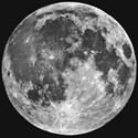
Image credit: NASA
The full moon on February 27 is going to be the brightest one of 2002. The moon’s orbit isn’t a perfect circle; over the course of its 28-day trip around the Earth, its distance varies from 406,700 km to 356,400. And today’s full moon happens to coincide with the closest point of that orbit, making it 20% brighter than an average full moon.
A pale ray of light shines through the bedroom window. In the distance, something howls. Eyes open. The clock ticks, it’s 2 a.m.. You’re wide awake — roused by a bright full Moon.
Don’t be surprised if this soon happens to you. The Moon will become full on Feb. 27th. It happens every 29.5 days, yet this full Moon is special: It’s the biggest and brightest of the year.
“Not all full Moons are alike,” says astronomy professor George Lebo. “Sometimes pollution or volcanic ash shades them with interesting colors. Sometimes haloes form around them — a result of ice crystals in the air.”
“This full Moon is unique in another way,” he says. “It will be closer to Earth than usual.”
Right: The apparent size of the Moon at perigee (top) and apogee (bottom).
“The moon’s orbit around our planet is not a perfect circle,” Lebo explains. “It’s an ellipse.” At one end of the ellipse (called apogee) the Moon lies 406,700 km from Earth. At the other end (called perigee) the Moon is only 356,400 km away — a difference of 50 thousand km!
When the Moon is full on Feb. 27th it will be near perigee — close to Earth. As a result the Moon will appear 9% wider than normal and shine 20% brighter.
The extra moonlight is caused, in part, by the Moon’s nearness to Earth. But that’s not all. The Sun is closer to Earth, too. Lebo explains: “Every year during northern winter, Earth is about 1.6% closer to the Sun than normal. (Like the Moon’s orbit around Earth, Earth’s orbit around the Sun is elliptical. Our closest approach to the Sun is called perihelion.) The Moon reflects sunlight, so the Moon is brighter during that time.”
This effect should not to be confused with the famous “Moon Illusion” — a trick of the eye that makes Moons rising near the horizon appear swollen. The nearby full Moon this week really will be bigger and brighter.
Below: The brightness of full Moons in 2002 relative to that of an average full Moon. In Feb., for example, the Moon will be 20% brighter than average; in Aug. it will be 12% dimmer. These values take into account the varying distances of the Moon from Earth and of the Earth from the Sun.
The first three full Moons of 2002 are all brighter-than-average. All three happen when the Moon is near perigee, and when Earth is relatively close to the Sun. Full Moons later this year will be smaller and dimmer by comparison. For example, August’s full Moon — an “apogee Moon” — will be about one-third dimmer than February’s.
But will anyone notice the difference?
“The human eye can easily discern a 20 or 30% difference in the brightness of two similar light sources,” says eye doctor Stuart Hiroyasu. By that reckoning, a sky watcher could tell the difference between a bright perigee Moon and a dimmer apogee Moon. But the two Moons would have to be side by side to effect the comparison — not likely except in a science fiction movie!
Below: Our Moon’s appearance changes nightly. This time-lapse sequence (Credit: Ant?nio Cidad?o) shows what our Moon looks like during a lunation, a complete lunar cycle. [more]
Even the dimmest full Moons are very bright, notes Lebo. They outshine Sirius, the brightest star in the sky, by twenty-five thousand times. They cast shadows, and provide enough light to read by. “There’s really no such thing as a faint full Moon. It’s all relative.”
Nevertheless, some sky watchers will sense that this Moon has something “extra” — particularly northerners. Many northern landscapes in February remain covered with snow. Snow reflects about two-thirds of the light that hits it, while bare ground reflects only about 15%. A snowy moonlit landscape always seems remarkably bright.
Perigee, perihelion, snowy terrain — they all add up to a big dose of Moonlight. Can you tell the difference? There’s only one way to find out: Go outside and look!
Original Source: NASA Science Story
Cold Weather Delays Shuttle Launch
Unusually cold weather in Florida has forced NASA to push back Thursday’s launch of the space shuttle Columbia for its service mission to the Hubble Space Telescope. Officials are predicting temperatures only a few degrees above freezing, but significantly warmer on Friday (cold weather was a contributing factor to the Challenger disaster). During the 11-day flight, astronauts will add $172 million in upgrades to Hubble. (AP article)
Quikscat Satellite Goes Operational
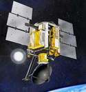
Weather forecasters have added wind speed and direction data from NASA’s Quick Scatterometer spacecraft (Quikscat) to help them predict violent storms as much as 6-12 hours before they happen. Launched almost three years ago, the Quikscat takes approximately 400,000 measurements every day, comprising 93% of the Earth’s surface. The spacecraft has proven its ability to improve forecasts of hurricanes, so several International weather agencies have decided to assimilate its data into their predictions.
In a move to improve global weather forecasts and ultimately save lives and property, the United States and Europe have incorporated wind speed and direction data from NASA’s Quick Scatterometer spacecraft-also known as Quikscat-into their operational global weather analysis and forecast systems.
Armed with data from Quikscat, forecasters can now predict hazardous weather events over the oceans as much as six to 12 hours earlier. Launched June 19, 1999, the Quikscat spacecraft operates in a Sun-synchronous, 800-kilometer (497-mile) near-polar orbit, circling Earth every 100 minutes, taking approximately 400,000 measurements over 93 percent of Earth’s surface every day.
In recent years, data from the Quikscat scatterometer, developed by NASA’s Jet Propulsion Laboratory, Pasadena, Calif., have proven useful in improving forecasts of extreme wind events, such as hurricanes, and in monitoring longer-term climatic effects such as El Nino. Quikscat’s SeaWinds scatterometer instrument is a specialized microwave radar that continuously measures both the speed and direction of winds near the ocean surface in all weather conditions.
Participants in the Quikscat program include the National Centers for Environmental Prediction, a branch of the National Weather Service, Washington, D.C., and the European Centre for Medium-Range Weather Forecasts, Reading, England. These organizations’ decision to assimilate and turn Quikscat data into operational information culminates an intense inter-agency and international cooperative effort among NASA, the National Oceanic and Atmospheric Administration (NOAA) and European countries to demonstrate and validate Quikscat’s potential impact on weather forecasting.
“Our implementation of Quikscat data has provided another useful data source for improved surface wind forecasts,” said Stephen Lord, director of the National Centers for Environmental Prediction’s Environmental Modeling Center, which developed the Quikscat data processing in collaboration with NASA and NOAA Satellite Service.
“The use of Quikscat data to improve weather forecasts underscores the value of the mission beyond the scientific research community,” said Dr. Michael Freilich, Quikscat principal investigator and a professor at Oregon State University, Corvallis. “Realizing the full potential of Quikscat data is possible only because of a series of unique collaborations. NASA researchers and engineers worked together to develop and calibrate the instrument and algorithms. NOAA personnel, in partnership with NASA, enable rapid delivery of near-real-time spacecraft data to forecast centers. There also are the teams of meteorologists who are developing and refining computer programs that incorporate the data into models and display measurements for forecasters.”
Helen Wood, director of NOAA’s Office of Satellite Data Processing and Distribution, said Quikscat data would positively impact NOAA’s weather forecasting and storm warnings. “Quikscat data will help our forecasters more accurately determine the paths and intensities of severe winter storms, tropical storms and hurricanes, which saves lives and property,” she said. “The data are also used by climate change researchers and commercial shipping interests.”
The incorporation of Quikscat data was one of several recent upgrades made to the European Centre for Medium-Range Weather Forecasts’ operational system. Cumulatively, the upgrades have resulted in a robust improvement in forecasts of atmospheric conditions over the Southern Hemisphere and in the upper atmosphere. Their ability to forecast tropical cyclone tracks has also been enhanced.
JPL manages Quikscat for NASA’s Office of Earth Science, Washington, D.C. JPL also built the scatterometer instrument and provides ground science processing systems. NASA’s Goddard Space Flight Center, Greenbelt, Md., managed development of the satellite, designed and built by Ball Aerospace & Technologies Corp., Boulder, Colo.
Original Source: NASA News Release
Ariane Rocket Places Intelsat Bird into Orbit
An Ariane 44L rocket lifted off from Kourou, French Guiana on Saturday at 0659 GMT (1:59am EST), carrying an Intelsat 904 communications satellite into orbit. The Intelsat satellite will provide video and data services for Asia, Africa and Europe. This was the second launch for Arianespace this year; an Ariane 5 is scheduled to launch on February 28.
Columbia Countdown Begins
NASA began the countdown on Monday for the upcoming launch the space shuttle Columbia on a mission to upgrade the Hubble Space Telescope. If all goes well, Columbia will lift off from the Kennedy Space Center on February 28 at 1148 GMT (6:48am EST). Over the course of the 11-day mission, astronauts will carry out five scheduled spacewalks to install new hardware, including a new camera, solar wings, a power-control unit, and steering mechanism. Forecasters are expecting a 70% chance that the weather will be good enough for launch.
Bow Shock in a Merging Galactic Cluster
A new image taken by the Chandra X-Ray observatory reveals a bow-shaped shock wave towards one side of an extremely hot galactic cluster. Astronomers believe that the shock wave is caused by 70 million degree Celsius gas is ploughed through the cluster at a speed of 10 million kph. This cluster is of great interest to astronomers because it’s one of the hottest clusters ever found – astronomers think that the galaxy might have gotten so hot because it absorbed many smaller clusters in the past.
Atlas III Lofts EchoStar Satellite
The second flight of the Atlas 3B rocket lifted off from Florida today, carrying an EchoStar 7 direct broadcasting satellite into orbit. This is an important launch for Lockheed Martin, as many of the parts of the upcoming Atlas 5, due for liftoff in May, were tested on this flight, including the upper stage booster. The flight was delayed twice, for a total of 30 minutes due to minor technical problems, but the rest of the launch seems to have gone flawless.
Martian Floods Could be Recent
Scientists from the University of Arizona believe that water may have erupted onto the surface of Mars as recently as 10 million years ago. As much as 600 cubic kilometres of water (four times the water in Lake Erie) may have poured out of fissures in the Cerberus Plains just north of the Martian equator. The scientists formed their theory after studying images taken of the region by the Mars Global Surveyor spacecraft.
Odyssey Mapping Mission Begins
After months of orbital manoeuvres, the Mars Odyssey spacecraft is ready to get to work searching for water on the surface of Mars. NASA flight controllers instructed the spacecraft to turn its scientific equipment towards the Red Planet on Monday. Operators expect it will take a few days to fully calibrate the equipment, and hope to release the first images to the public on March 1.