
An anaglyph of the moving topography of Nili Patera on Mars. Credit: NASA/JPL/University of Arizona
Get your 3-D glasses (the red-and-green kind) ready, we’re going on a trip to Mars.
Let your gaze drift across this anaglyph of the dunes of Nili Patera taken from NASA’s HiRISE camera aboard Mars Reconnaissance Orbiter. HiRISE images many targets twice, within seconds of each other, so scientists can see a location from different angles. The images are used to make more accurate maps. Only problem is, dunes move, making the job of a Mars mapper a little difficult.
Besides making a beautiful, but sometimes eye-bending, picture, the images are also used to make digital elevation models or DEMs. These DEMs can be precise within centimeters. If the pair of images are taken in an area that doesn’t change much, scientists can get a good elevation model. Scientists also get lucky when images are taken in quick succession as in the case of Nili Patera, a huge caldera near the Martian equator within the dark Syrtis Major Planum.
The dunes in this field of sand are active. By comparing the height of the moving dunes using the DEM, scientists find that these dunes are similar to Antarctic dunes which are driven by strong, sustained winds. One of the most surprising finds, according to the HiRISE website, is the notion that the dunes remain stable. Their entire volumes are made up of mobile sand. Similar to Earth, winds on Mars are capable of moving large amounts of sand meaning not only does wind drive dune migration but also landscaping such as sand blasting.
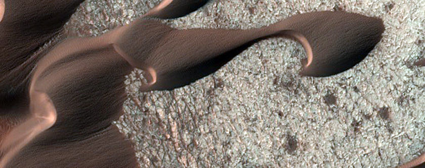
A close-up color version of one of the dunes in Nili Patera. Credit: NASA/JPL/University of Arizona
Source: HiRISE
Wow! Absolutely incredible to feel as though one is walking amongst the dunes! I like! Something that may not be known by many is that although the Martian air pressure and density is far lower than on Earth.. the CO2 which is the predominant gas.. is MUCH heavier! Consequently, the winds on Mars can be quite zignificant!
Just spent 2 hrs looking at this awesome incredible 3D photo.Scanning zooming in and out.The dunes windblown edges appear like giant cliffs .Some craters look very deep! Is this realistic or stretched by the 3d affect more than one would see if you were orbiting and looking down at the same perspective height as the photo?
3D views are often incredible to look at but images such as this give a chance to do some serious work on Martian topography. Thanks for the link Fraser, I will be spending a lot of time with this image!
Funny, I don’t see sand around these supposed dunes. It’s more likely bio-life engineered as shelters