
[/caption]
The boundary where Earth’s crust gives way to the unexplored mantle was first detected in 1909, because of a change in the travel of seismic waves. Named the Moho boundary for Andrija Mohorovicic, who listened to those seismic waves, the crust-mantle boundary is a frontier that remains elusive and compelling — harboring tantalizing clues as to the story of Earth’s formation — even as our technologies push into the outer reaches of the solar system and beyond.
The first serious attempts to probe the Moho boundary ran aground in the late 1950s. Now, technology already in use on a Japanese ship, combined with a United States digging program already under way, could finally yield success. Damon Teagle and Benoît Ildefonse have written about the ongoing efforts for an article in the journal Nature, released today.
Teagle is at the University of Southampton’s National Oceanography Centre in the UK, and Ildefonse is at Université Montpellier in France. They are co-chief scientists on an expedition called the IODP Expedition 335, “to obtain for the first time a section of the lower oceanic crust — the material lying just above the mantle,” they write.
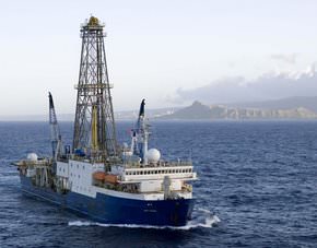
The IODP is using the U.S. ship JOIDES Resolution, pictured above, which will drill from April to June this year off the coast of Costa Rica.
“This site is in ocean crust that formed superfast — at more than 20 centimetres a year, much faster than any present day crust formation,” the co-authors write. “That makes the upper crust there much thinner than elsewhere, so it is possible to reach the lower portions without having to drill very deep. Three previous expeditions to Hole 1256D have drilled down to more than 1.5 kilometres below the sea floor, into the transition zone between dikes and gabbros.”
This spring they hope to push it another 400 meters, and recover gabbros from the lower crust, “which will be the deepest types of rock ever extracted from beneath the sea floor,” even though the deepest hole reached 2,111 meters under the eastern Pacific off of Colombia, they write.
Teagle and Ildefonse note that some pieces of the mantle have been thrust up to Earth’s surface during tectonic mountain building, and ejected from volcanoes and sea floor dikes. Those samples have provided clues to the mantle’s composition, but they don’t reveal the variability of the mantle — and all of the samples have been altered by the processes that revealed them.
They say the IODP mission should help to settle many debates, including how crust is formed at mid-ocean ridges, how magma from the mantle is intruded into the lower crust, the geometry and vigor of how sea water can pull heat from the lower oceanic crust and the contribution of the lower crust to marine magnetic anomalies. The project will also provide “further impetus for, and confidence in, deep ocean crust drilling,” write Teagle and Ildefonse — but it will reach a depth far less than what will be needed to actually get at the Moho boundary. It occurs at least 30 kilometers (18 miles) under the continents but just 6 kilometers (3.7 miles) under the seas.
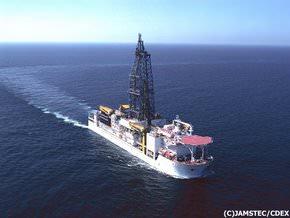
That’s where Chikyu comes in. Launched in 2002, “Chikyu is a giant ship, capable of carrying 10 kilometres of drilling pipes, and is equipped for riser drilling in 2.5 kilometres of water,” the authors write. Although Chikyu wouldn’t yet be able to go the full distance, its design is advanced enough to be the launching pad for such efforts:
“The vessel has a riser system: an outer pipe surrounds the drill string — the steel pipe through which cores are recovered,” the co-authors write. “The drilling mud and cuttings are returned up to the vessel in the space between the two pipes. This helps to recycle the drilling mud, control its physical properties and the pressure within the drill hole and helps to stabilize the borehole walls.”
Teagle and Ildefonse say the ideal drilling program to reach the mantle boundary will happen in one of three places — off the coasts of Hawaii, Baja California and Costa Rica — where the water is the most shallow, over the coldest possible crust. Wherever and however it happens, they write, it will be worth doing:
“Drilling to the mantle is the most challenging endeavour in the history of Earth science. It will provide a legacy of fundamental scientific knowledge, and inspiration and training for the next generation of geoscientists, engineers and technologists.”
Source: Nature. See also the websites for Chikyu and JOIDES.
The mohorovicic boundary was one of the first things i ever learned of in the field of geology, it’s great to see this development in exploration!
And oil would be a nice bonus. 😀
I thought undifferentiated primary magma melt was mantle material. If so what would this drilling sample tell us that the primary magma melt doesn’t?
From my meager knowledge magma is a local melt, often of the crust (though I gather there are seismically observed magma reservoirs in the mantle as well).