[/caption]
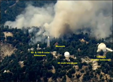
The wildfires near Los Angeles have spread to over 100,000 acres. The Los Angeles Times reported that the fire had burned 74 structures and remained out of control, spreading both west and north. As of 6:30 p.m. Pacific Daylight Time on August 31, some 12,000 homes were threatened. Fire fighters struggled to save the Mt. Wilson Observatory from the encroaching fire. Today, fire fighters set controlled backfires in effort to remove the closest vegetation to the various telescope structures. See below for a labeled image of the structures on Mt. Wilson amid smoke from the fires, courtesy of Emily Lakdawalla of the Planetary Society, along with more satellite, ground and helicopter images from the fires.

Imagery from Mt. Wilson’s tower camera, recently went offline, likely due to loss of power. They have a back up site, available here, and staff from the observatory are still posting updates. While it was alarming to see the observatory structures surround and sometimes not visible because of smoke, the Mt. Wilson staff assured that they structures were still safe, and the fires were planned:
The [fire fighter’s] plan, which they would have implemented earlier had they not been withdrawn, was to start these groundlevel fire and literally walk along with them to keep them controlled. This is why we see no flames. The fires will consume the accumulation of needles from the many pine and fir trees as well as other scrub growth that could flame up and ignite lower limbs that would them permit the blossoming of the entire tree into flames. All the smoke we see is entirely consistent with this procedure. Larry and Dave are both delighted to see what’s going on, but I’ve got to say that seeing smoke next to those domes is very unsettling to me. Still, I know what the fire fighters are now doing is necessary to save the Observatory.
The latest news is that 4 acres of water is going to be dropped on the north side of Mt.W towers on Tuesday afternoon in an effort to save the observatory and communications towers.
A live view from a helicopter from station KTLA is available here. UPDATE: That feed is cutting out frequently due to demand. Try this one instead. (It is from a Fox station from anyone who thinks I have something against Fox….)
View this link to see a map of where the fire has spread. It is a Google map that is updated frequently.
The Los Angeles times blog reports that the “Station” fire, as it is called, in Angeles National Forest has been creeping east, toward the center of the San Gabriel Mountains. But its growth has been slower in the last 24 hours than it was over the weekend, thanks to higher humidity.
The fire’s maximum borders are roughly 25 miles from west to east and 18 miles north to south, covering the entire length of Angeles National Forest.
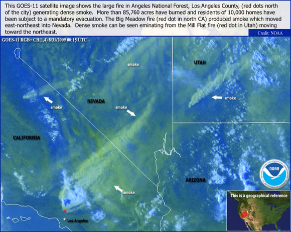
This image from NASA’s GOES-O satellite shows how far the smoke from the fires has spread.


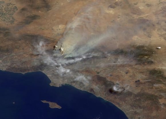
This image was acquired mid-morning on Aug. 30 by the backward (northward)-viewing camera of the Multi-angle Imaging SpectroRadiometer (MISR) instrument on NASA’s Terra satellite. The image is shown in an approximate perspective view at an angle of 46 degrees off of vertical. The area covered by the image is 245 kilometers (152 miles) wide. Several pyrocumulus clouds, created by the Station Fire, are visible above the smoke plumes rising from the San Gabriel Mountains north of Los Angeles in the left-center of the image. Smoke from the Station fire is seen covering the interior valleys along the south side of the San Gabriel Mountains, along with parts of the City of Los Angeles and Orange County, and can be seen drifting for hundreds of kilometers to the east over the Mojave Desert.
This striking time-lapse video of the fires at sunset, taken on August 29 from Mulhulland Drive in Los Angeles, show the fires spreading.
Sources: Mt. Wilson observatory website fire update, Los Angeles Times, New York Times, NASA Earth Observatory


47 years I visited this holy place and I never will forget it. Horray for all the hard working people working to save it. It is looking better but the fire does yet rage.
Did you know you rent the 60in for a night? Only $1600 and it includes two guides for party up to 25! I will saving my boxtops for that boys and girls!