
Want to discover an impact crater, and even get it named after you? All you’ve got to do is spend a few (hundred) hours poring over images in Google Earth or Google Maps. That’s exactly what Geologist Arthur Hickman did, turning up a previously unknown impact crater when he was searching for iron ore in the mountains of West Australia.
While he was browsing through images on Google Earth, Hickman’s geology training helped him recognize the circular shape and raised rim of an impact crater. He sent a screenshot and coordinates to colleagues at Australian National University, and they confirmed that it’s a well-preserved meteor crater between 10,000 and 100,000 years old. And until now, totally unknown.
You can take a look at the crater for yourself on Google Maps.
This isn’t the first time a crater has been discovered using Google Earth. One was found in the Saharan Desert two years ago. That crater is 31 km (19 miles) across – much bigger than Meteor Crater in Arizona.
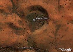
The newly named “Hickman Crater” measures 270 metres (885 feet) across, and is about 35 km north of Newman, Australia. The region was mapped by the Geological Survey of Western Australia about 20 years ago, but the crater went unnoticed until now.
Since large meteorites hit the Earth every few thousand years, and when you consider that the landscape is millions of years old, there are many regions hiding meteorite impacts.
They’re just waiting for you to find them.
Original Source: ScienceAlert
> i wish i had my own crater
Careful! It’s only a crater if it has been checked on the ground – as in this case – and fulfils several hard criteria. Most ‘Google Earth impact craters’ turn out to be duds; there was another such case just days ago …
I find it just amazing that you can look for iron ore on publicly available resources. Whats next? Oil?
Well, perhaps if there are massive puddles of oil leaking from the ground going unnoticed, you might be able to. 🙂
Seams of iron ore are often exposed to the surface, and I guess that a trained geologist would be able to spot telltale signs from good quality satellite maps. No doubt he knew where to look from previous geological surveys done in the area.
that’s awsome. i wish i had my own crater 🙂
Nevertheless, for frustrated Amateur planetary scientists, searching Google maps (and their equivalents) for impact craters would seem an admirable past-time.
What interesting is how and whom do I report if I believe that I’ve found a crater.
Whenever I get discouraged by all the low life stuff on the internet, something like this comes along an renews my faith in the human race. The internet, with all the pitfalls of horrific content, is without precident in human history, that of a creating a global society. I know this seems like a heavy comment on something that could really be considered a footnote, but for some reason it triggered a great appreciation of the oportunities that the internet is offing.
Agree with Dave. First the industrial revolution, then the computer revolution. Since for all practical purposes, we may soon be able to know what everybody is doing all the time, we may have the behavioral revolution . . . but I hope not.
Try google earthing the south east Libya desert. There are 2 craters very close to each other (Kebira and Oasis) and the soil hasnt been disturbed by sand dunes and rain for a very very long time. I was sure I had seen more when I looked a year or so ago.
“What interesting is how and whom do I report if I believe that I’ve found a crater.”
Try contacting the relevant government geological survey and university geology departments.
In either case make you sure are familar with criteria for impact craters and give as much infomation as you can.
Good luck!
Jon
Zoom out one or two steps on the Google image.
Now, is it just me, or is that crater, in reality, the mouth of a giant petrified horned demon??
Or perhaps it was built by an ancient Martian civilization, after they completed the Face on Mars, and then were forced to abandon Mars due to the drying up of the canals, and migrate to Earth. Upon which they built this monument to, umm, maintain a connection to their ancient home, and immortalize their angst at its loss.
Then again, it does look a bit like Elvis…
Well I found a crator a bout 5 years ago on sat images. I am sure it is a crator. I have have since wondered how to get the site reported. As for getting it named after me, well heck that would be like a life acheavement.
Oh… Part of the crator is public land. The crator is about 400 meters or so wide and maybe 2 meters deep. The crator is a perfect circle except for a slite liptical shape like what made it was coming at an angle.
Gary
has anybody ever researched st magnus bay in shetland?i’m sure the whole bay is an impact crater,with the outer rim of debris streaching miles inland over the mainland north south and east.even the sea charts of the area show a very crater like bottom to the sea of the bay.
If that is the case i claim the crater at 21° 21′ 34.53″N 17° 01′ 33.59″W or 21.359592, -17.025997? as AUGOLDMINER’S meteor crater
and have marked it on http://www.wikimapia.org/
does anyone know if this is one?
http://maps.google.com/maps?f=q&hl=en&geocode=&q=-23,119.6&ie=UTF8&t=h&ll=-21.78672,115.947196&spn=0.002635,0.002977&z=18
It is amusing to see so much hoopla about another puny impact crater among millions visible on the surface of our planet. Since satellite imagery has been around for nearly 50 years, its interesting that so few impact craters have been defined…at last count less than 200 impact craters are listed in the standard databases.