
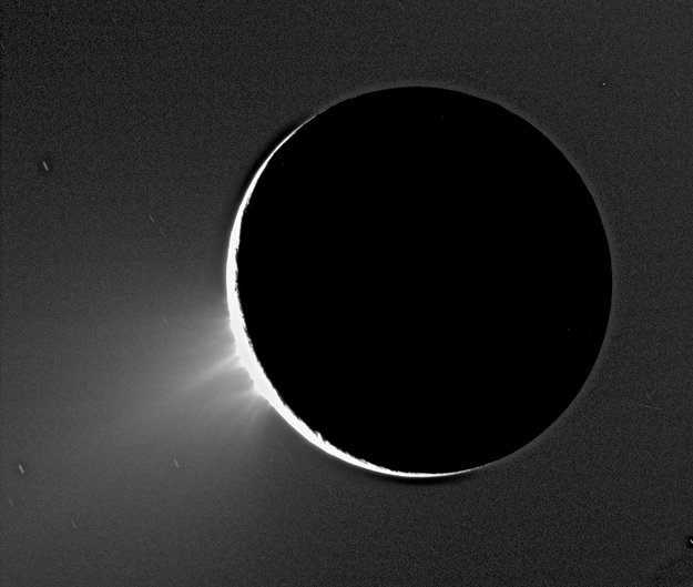
Ever since the Cassini spacecraft first spied water vapor and ice spewing from fractures in Enceladus’ frozen surface in 2005, scientists have hypothesized that a large reservoir of water lies beneath that icy surface, possibly fueling the plumes. Now, gravity measurements gathered by Cassini have confirmed that this enticing moon of Saturn does in fact harbor a large subsurface ocean near its south pole.
“For the first time, we have used a geophysical method to determine the internal structure of Enceladus, and the data suggest that indeed there is a large, possibly regional ocean about 50 kilometers below the surface of the south pole,” says David Stevenson from Caltech, a coauthor on a paper on the finding, published in the current issue of the journal Science. “This then provides one possible story to explain why water is gushing out of these fractures we see at the south pole.”
On three separate flybys in 2010 and 2012, the spacecraft passed within 100 km of Enceladus, twice over the southern hemisphere and once over the northern hemisphere.
During the flybys, the gravitational tug altered a spacecraft’s flight path ever so slightly, changing its velocity by just 0.2–0.3 millimeters per second.
As small as these deviations were, they were detectable in the spacecraft’s radio signals as they were beamed back to Earth, providing a measurement of how the gravity of Enceladus varied along the spacecraft’s orbit. These measurements could then be used to infer the distribution of mass inside the moon.
For example, a higher-than-average gravity ‘anomaly’ might suggest the presence of a mountain, while a lower-than-average reading implies a mass deficit.
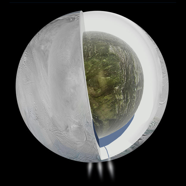
On Enceladus, the scientists measured a negative mass anomaly at the surface of the south pole, accompanied by a positive one some 30-40 km below.
“By analyzing the spacecraft’s motion in this way, and taking into account the topography of the moon we see with Cassini’s cameras, we are given a window into the internal structure of Enceladus,” said lead author Luciano Iess.
“This is really the only way to learn about internal structure from remote sensing,” Stevenson added.
The only way to get more precise measurements would be to put seismometers on Enceladus’s surface. And that’s not going to happen anytime soon.
Stevenson said the key feature in the gravity data was the negative mass anomaly at Enceladus’s south pole. This happens when there is less mass in a particular location than would be expected in the case of a uniform spherical body. Since there is a known depression in the surface of Enceladus’s south pole, the scientists expected to find a negative mass anomaly. However, the anomaly was quite a bit smaller than would be predicted by the depression alone.
“The perturbations in the spacecraft’s motion can be most simply explained by the moon having an asymmetric internal structure, such that an ice shell overlies liquid water at a depth of around 30–40 km in the southern hemisphere,” Iess said.
While the gravity data cannot rule out a global ocean, a regional sea extending from the south pole to 50 degrees S latitude is most consistent with the moon’s topography and high local temperatures observed around the fractures – called ‘tiger stripes’ at Enceladus south pole.
Many have said Enceladus is one of the best places in the Solar System to look for life. Noted scientist Carolyn Porco and Chris McKay have a recent paper out titled, “Follow the Plume: The Habitability of Enceladus,” where they say that since analysis of the plume by the Cassini mission indicates that the “steady plume derives from a subsurface liquid water reservoir that contains organic carbon, biologically available nitrogen, redox energy sources, and inorganic salts” that samples from the plume jetting out into space are accessible with a low-cost flyby mission. “No other world has such well-studied indications of habitable conditions.”
These latest findings by Cassini make a mission to Enceladus even more enticing.
Paper in Science (paywall) “The Gravity Field and Interior Structure of Enceladus.”
Sources: ESA, Caltech
Confirmed? Based on what? A few flybys and some fuzzy math? Stories like this make my blood boil! There is no evidence and nothing is confirmed, it’s speculation.
I’ll wager the maths that were used are a bit beyond your capabilities, eh? How would YOU explain the images Cassini has taken of the icy geysers?
I like how thomasguide dismisses the evidence. A “few” flybys, as if we can’t learn anything from just one flyby.
I’m willing to bet he doesn’t even know what fuzzy math is. A question for you thomas: how does fuzzy math apply to this discovery? I don’t see any relevance to Lotfi Zadeh’s work on fuzzy sets or any of the subsequent developments in that particular branch of mathematics.
“…The perturbations in the spacecraft’s motion can be most simply explained by the moon having an asymmetric internal structure, such that an ice shell overlies liquid water at a depth of around 30–40 km in the southern hemisphere…” I assume you read this in the article you’re critiquing? The words DO mean something, BTW…. And what does “fuzzy math” mean when you use the term…? “I don’t understand it”?
Fly by mission would be very interesting! Is the ice shell mostly water also?
A future mission to detect life won’t have to land; won’t have to drill down to the subsurface ocean. It will just have to fly through the plume because there should be signs of life spewing out of those water volcanoes. Bad for the unfortunate critters thrown out of the ocean, but great for our understanding of life in the universe.
A future low altitude flyby mission would need good windshield (spaceshield?) wipers to clean off all the shattered, frozen debris from the fish-analogue type creatures with shocked looks on their faces that have been frozen in time after they were jetted into space! Also, a strong windshield! 🙂
Congratulations. The water seems further down than anticipated. I heard 2 to 10 kilometres, maybe 20, but not 50. That would make drilling down to the water very difficult. Let alone sending down a camera. And how does the water get to the surface through 50K of ice without freezing? After that it blasts a hundred kilometres or more into space – clearly it is under very high pressure which may be the answer. But the fissures would have to be at least the size of a wide creek for it to get to the surface with such quantity. Too little and too slow, it freezes. Over millions of years, wouldn’t the “underground sea” be drained? This system is not well understood. Most importantly, how does one explain the huge amount of liquid water so far out in the solar system? The “Cinderella Zone” must have been much larger in the distant past for oceans to form on moons around Saturn.
The ice keeps melting to make more water…, and what is your degree in that allows you to so easily calculate off the cuff how large these fissures need to be and how easily the water that they channel would freeze on the way out…? Oh, in “nothing, but wild speculation yourself”? Ah, I understand now…..
Thanks Jeffrey. One doesn’t need a science degree to observe water and its freezing in various situations. Has anyone said that water, frozen or liquid, operates much differently elsewhere than it does here on earth? Niagara Falls between the US and Canada froze over this winter despite a significant amount of water coming down the very wide and fast moving Niagara River from Lake Erie. The reason? Months long, sub zero, temperatures. Rivers freeze from the sides out, from ice already formed because those are the coldest and usually slower moving areas. Smaller streams with less quantity and velocity freeze faster. Water also freezes from the top down, but eventually the whole thing is frozen. First cold air freezes the surface, then the ice below freezes water further down. An upwelling 50K in length would freeze solid unless there was enough width and pressure to make it to the surface. It would be a surprise if a lot of water was seeping out – it couldn’t make it up that far or blast into space; ice at the top would act as a plug. These points are readily apparent skating on frozen ponds and being around water and ice in winter. You might have something very interesting about the temperature of the water down below. If other factors were continually warming it, that might prevent it from totally freezing and help keep some fissures to the surface open too. Just wild speculation.